From Surf Wiki (app.surf) — the open knowledge base
1833 Sumatra earthquake
Seismic event
Seismic event
| Field | Value | |
|---|---|---|
| title | 1833 Sumatra earthquake | |
| pre-1900 | yes | |
| local-date | ||
| local-time | 22:00 | |
| map2 | {{Location map | Indonesia Sumatra |
| lat | -2.5 | |
| long | 100.5 | |
| mark | Bullseye1.png | |
| marksize | 40 | |
| position | top | |
| width | 250 | |
| float | right | |
| caption | }} | |
| magnitude | 8.8–9.2 Mw | |
| intensity | VIII (*Heavily damaging*) | |
| location | ||
| countries affected | Sumatra, Dutch East Indies | |
| fault | Sunda megathrust | |
| tsunami | Yes | |
| casualties | Unknown |
|pre-1900 = yes |local-date= |local-time = 22:00
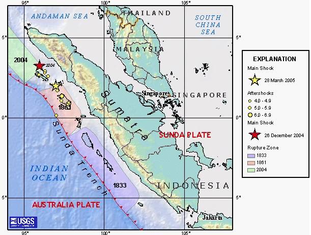
The 1833 Sumatra earthquake occurred on November 25 at about 22:00 local time, with an estimated magnitude in the range of 8.8–9.2 . It caused a large tsunami that flooded the southwestern coast of the island. There are no reliable records of the loss of life, with the casualties being described only as 'numerous'. The magnitude of this event has been estimated using records of uplift taken from coral microatolls.
Background
The island of Sumatra lies on the convergent plate boundary between the Indo-Australian plate and the Eurasian plate. The convergence between these plates is highly oblique near Sumatra, with the displacement being accommodated by near pure dip-slip faulting along the subduction zone, known as the Sunda megathrust, and near pure strike-slip faulting along the Great Sumatran fault. The major slip events on the subduction zone interface are typically of megathrust type. Historically, great or giant megathrust earthquakes have been recorded in 1797, 1833, 1861, 2004, 2005 and 2007, most of them being associated with devastating tsunamis. Smaller (but still large) megathrust events have also occurred in the small gaps between the areas that slip during the larger events, in 1935, 1984, 2000 and 2002.
Damage
There is only sparse information available regarding the extent of damage associated with either the earthquake or the subsequent tsunami. However, the tsunami was clearly devastating along the southwest coast of Sumatra from Pariaman to Bengkulu. There is also a lone report of significant damage in the Seychelles. The tsunami also caused severe damage in the Maldives and Sri Lanka. Waves have also been reported to reach northern Australia, the Bay of Bengal and Thailand, although in small intensity.
Characteristics
Earthquake
The earthquake shaking lasted 5 minutes in Bengkulu and 3 minutes in Padang, combined with the severity this suggests a very large source rupture. The rupture extent and the magnitude of this earthquake has been determined using the effect of relative sea level changes on coral microatolls from a group of small islands along the outer arc ridge that runs parallel the coast of Sumatra, the Mentawai islands. These microatolls, named for their resemblance to island atolls, can be used to provide a record of sea level change. Microatolls form because the coral head cannot grow up beyond low tide level (known as highest level of survival or HLS) as exposure leads to death. The morphology of the microatolls directly reflects changes in HLS. The presence of annual growth banding combined with the Uranium-thorium dating method allows morphological changes to be dated, with an uncertainty of only a few years to a few decades.
Tsunami
Modelling of the tsunami suggests that most of the energy would have been radiated out into the Indian Ocean, sparing most coastal population centres outside Sumatra itself. Detailed modelling around Sumatra matches well with limited observations available.
References
References
- Natawidjaja, D. H.. (2006). "Source parameters of the great Sumatran megathrust earthquakes of 1797 and 1833 inferred from coral microatolls". Journal of Geophysical Research.
- Okal, E.A.. (2008). "Far-field tsunami hazard from mega-thrust earthquakes". [[Geophysical Journal International]].
- (25 November 2014). "25-11-1833: Alam Hening...Lalu Gempa Dahsyat Guncang Sumatera".
- Cummins, Phil. (March 2005). "The Boxing Day 2004 tsunami—a repeat of the 1833 tsunami?". Geoscience Australia.
- Borrero, J.C.. (December 26, 2006). "Tsunami inundation modeling for western Sumatra". Proceedings of the National Academy of Sciences.
- (2022). "Gempa Nusantara: A Database of 7380 Macroseismic Observations for 1200 Historical Earthquakes in Indonesia from 1546 to 1950". Bulletin of the Seismological Society of America.
This article was imported from Wikipedia and is available under the Creative Commons Attribution-ShareAlike 4.0 License. Content has been adapted to SurfDoc format. Original contributors can be found on the article history page.
Ask Mako anything about 1833 Sumatra earthquake — get instant answers, deeper analysis, and related topics.
Research with MakoFree with your Surf account
Create a free account to save articles, ask Mako questions, and organize your research.
Sign up freeThis content may have been generated or modified by AI. CloudSurf Software LLC is not responsible for the accuracy, completeness, or reliability of AI-generated content. Always verify important information from primary sources.
Report