From Surf Wiki (app.surf) — the open knowledge base
2007 Bengkulu earthquakes
Earthquakes affecting Indonesia
Earthquakes affecting Indonesia
| Field | Value | |
|---|---|---|
| title | 2007 Bengkulu earthquakes | |
| timestamp-A | 2007-09-12 11:10:26 | |
| timestamp-B | 2007-09-12 23:49:03 | |
| anss-url-A | official20070912111026830_34 | |
| anss-url-B | usp000fn2b | |
| isc-event-A | 13203322 | |
| isc-event-B | 13203366 | |
| local-time-A | 18:10 | |
| local-time-B | 06:49 | |
| local-date | ||
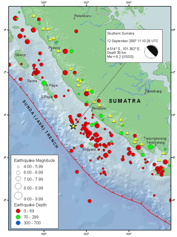
| map | Sumatra 2007 earthquakes map.gif | |
| image name | Map showing the 3 large quakes and 22 pre and aftershocks in a span of 24 hours. | |
| map2 | {{Location map | Indonesia Sumatra#Indonesia |
| relief | yes | |
| mark | Bullseye1.png | |
| marksize | 40 | |
| position | top | |
| width | 250 | |
| float | right | |
| caption | }} | |
| magnitude-A | 8.4 | |
| magnitude-B | 7.9 | |
| depth | 34.0 km | |
| location | ||
| type | Megathrust | |
| tsunami | Yes | |
| countries affected | Indonesia | |
| Singapore | ||
| Malaysia | ||
| Thailand | ||
| casualties | 25 dead, 161 injured | |
| tags | y | |
| intensity |
| timestamp-A = 2007-09-12 11:10:26 | timestamp-B = 2007-09-12 23:49:03 | anss-url-A = official20070912111026830_34 | anss-url-B = usp000fn2b | isc-event-A = 13203322 | isc-event-B = 13203366 | local-time-A = 18:10 | local-time-B = 06:49 | local-date =
| magnitude-A = 8.4 | magnitude-B = 7.9
Singapore Malaysia Thailand
The 2007 Bengkulu earthquakes were a series of megathrust earthquakes that struck the Sunda Trench off the coast of Sumatra, Indonesia, with three of magnitude 7 or greater. A series of tsunami bulletins was issued for the area. The most powerful of the series had a magnitude of 8.4, which makes it in the top 20 of the largest earthquakes ever recorded on a seismograph.
Timeline
The first earthquake occurred at 11:10:26 UTC (18:10 local time) on 12 September 2007, and was an 8.4 earthquake on the moment magnitude scale. It had a focal depth of 34 km, at , about 130 km southwest of Bengkulu on the southwest coast of Sumatra, Indonesia, and some 600 km west-northwest of Indonesia's capital city, Jakarta. It was followed by several earthquakes of magnitude 5 through 6 along the same fault, west of Sumatra.
The second largest earthquake, 7.9 Mw, occurred later the same day at 23:49:04 UTC (06:49:04 local time the following day). It was centred about 35 km underground, at , some 185 km south-southeast of Padang, Indonesia and about 205 km northwest of Bengkulu (about 225 km northwest of the magnitude 8.4 earthquake).
After further aftershocks above magnitude 5, a third large earthquake, 7.0 Mw, occurred at 03:35:28 UTC (10:35:28 local time) on 13 September.
Aftershocks continued into 13 September and 14 September, with more earthquakes ranging up to magnitude 6.4. Most of the aftershocks have been northwest of the original magnitude 8.4 earthquake. A 6.7 struck Southern Sumatra on Sept 20, 2007.
Tidal buoys positioned in the Indian Ocean and other seismic tools have led scientists to issue a series of tsunami bulletins.
Effects
The tremors of the 8.4 earthquake lasted for several minutes. It caused buildings to sway in Jakarta, and some buildings were reported to have collapsed in the city of Bengkulu, Bengkulu Province, about 100 km (62 mi) from the epicenter. Tremors felt in Jakarta were described as being "violent". It was reported that several high-rise buildings were evacuated. The earthquake also led to a power outage in Bengkulu, which crippled communications. The death toll of the earthquakes is 25 with 161 people injured.
Tremors were felt in neighbouring countries as far away as Southern Thailand. In Singapore, which is about 670 km (416.3 mi) from the epicenter, the tremor was felt at around 11:10 UTC (19:10 local time). Most of the Central and Eastern part of Singapore had felt the tremor. In Peninsular Malaysia, tremors were reported after 19:15 local time, including Kuala Lumpur, Putrajaya, Johor Bahru, Malacca and Penang. Like Singapore, the tremors were most severe on high-rises, resulting in minor panic and evacuations. No casualties were reported in the country, as of 13 September.
Tsunami
Sea level readings indicated that a tsunami was generated. A total of 4 tsunami alerts were issued in 24 hours. After the first, and largest, earthquake, the Pacific Tsunami Warning Centre issued a tsunami alert for much of the Indian Ocean basin. A tsunami approximately 1 metre high was reported at Padang, Indonesia. A 1.5 metre tsunami was observed in Sikakap beach on South Pagai Island. A small tsunami, some 15 cm high, was reported at the Cocos Islands. Sumatra was taken off tsunami alert after two hours. A weak tsunami caused some damage in Serangai, located north of Bengkulu. The tsunami had a flow depth of 3.5 m and maximum run-up of 5 m, measured on a cliff top.
Tsunami warnings were also issued in India and other countries around the Indian Ocean soon after the earthquake. The Government of India asked the states of Tamil Nadu, Kerala, Andhra Pradesh and the union territories of Andaman and Nicobar Islands and Puducherry to be on high alert. By late 12 September, the tsunami warning was recalled. Similarly, a tsunami alert was issued in Peninsular Malaysia at 20:50 (local time) for the coastal areas of Perlis, Kedah, Perak and Penang; the alert was lifted two hours later. However, Malaysian authorities had detected a 1–3 m high tsunami heading away from the epicenter of the earthquake.
Tectonic summary
According to the US Geological Survey, the earthquake was caused by thrust faulting on the boundary between the Australian Plate and the Sunda Plate which ruptured a 250 × 170 km section of the subduction interface. At the location of the earthquake, offshore of the west coast of Sumatra, the Australia plate moves northeast with respect to the Sunda Plate at a velocity of about 69 mm/year, oblique to the orientation of the plate boundary. The component of plate motion perpendicular to the boundary produces thrust faulting on the offshore plate-boundary.
The magnitude 7.9 earthquake was also a result of thrust faulting on the same plate boundary. It occurred about 225 km northwest of the magnitude 8.4 earthquake, at the northern end of the aftershock zone. This event ruptured 2 different patches of the interface, each separated by a distance of 120 km and around 50 × 40 km in size or less.
The magnitude 8.4 earthquake was the most powerful earthquake of 2007 to date, more powerful than the two March 2007 Sumatra earthquakes nearby and the 2007 Peru earthquake. It was the second most powerful earthquake since the magnitude 9.3 2004 Indian Ocean earthquake, exceeded only by the magnitude 8.6 2005 Nias–Simeulue earthquake. The two largest earthquakes were the fourth and fifth earthquakes with magnitude 7.9 or greater to have occurred on or near the plate boundaries offshore of western Sumatra in 7 years, the others being the magnitude 7.9 earthquake of 4 June 2000; the magnitude 9.3 2004 Indian Ocean earthquake on 26 December 2004; and the magnitude 8.6 Nias–Simeulue earthquake on 28 March 2005.
According to data from the Japanese PALSAR microwave sensor aboard the Daichi(ALOS) satellite, South Pagai Island was uplifted, creating 6 new islands, and exposing previously submerged coral reefs as well as enlarging existing islands.
References
References
- Stefano Lorito, Fabrizio Romano, Alessio Piatanesi, Enzo Boschi. (2008). "Source process of the September 12, 2007, MW 8.4 southern Sumatra earthquake from tsunami tide gauge record inversion". Geophysical Research Letters.
- ISC. (2022). "ISC-GEM Global Instrumental Earthquake Catalogue (1904–2018)". [[International Seismological Centre]].
- {{Cite anss. Sumatra. 2007. usp000fn2b. M 7.9 – 87 km SW of Sungai Penuh, Indonesia
- It was centred about 10 km underground, at {{coord. 2.130. S. 99.627. E. Sumatra. 2007. usp000fn3d. M 7.0 – 153 km SSW of Padang, Indonesia
- [https://earthquake.usgs.gov/eqcenter/recenteqsww/Quakes/quakes_big.php Latest Quakes +5.0M] {{webarchive. link. (October 7, 2009 [[USGS]])
- [http://www.ndbc.noaa.gov/station_page.php?station=23401 DART Buoy Station 23401 – 600 NM West-Northwest of Phuket, Thailand]
- [http://www.prh.noaa.gov/ptwc/?region=3&id=indian.2007.09.13.002807 Message Indian.2007.09.13.002807 Pacific Tsunami Warning Center, NWS], [[NWS PTWC]]
- [https://news.bbc.co.uk/2/hi/asia-pacific/6991294.stm Eyewitnesses: Sumatra earthquake], [[BBC News]]
- [https://news.bbc.co.uk/2/hi/asia-pacific/6991134.stm Powerful quake shakes Indonesia], [[BBC News]]
- "Tsunami alert issued after Indonesia quake: US centre".
- [https://pasadena.wr.usgs.gov/shake/ous/STORE/X2007hear/ciim_display.html Event 2007hear: View Map] {{webarchive. link. (September 15, 2007)
- "Singapore buildings sway after strong quake hits Indonesia".
- [http://www.channelnewsasia.com/tremor/map.htm Map] {{webarchive. link. (October 4, 2007)
- (2007-09-13). "8.2 magnitude quake sparks tsunami warnings". [[The Sun (Malaysia).
- (2007-09-13). "Quake felt in Malaysia". [[The Star (Malaysia).
- [https://web.archive.org/web/20070929104710/http://www.thejakartapost.com/detailgeneral.asp?fileid=20070912203110&irec=2 Powerful earthquake triggers tsunami in western Indonesia], ''[[The Jakarta Post]]''
- [https://web.archive.org/web/20070915165810/http://www.abs-cbnnews.com/storypage.aspx?StoryId=92279 Six dead, dozens injured in Indonesian quakes], [[Agence France-Presse]] via [[ABS-CBN Corporation]]. Retrieved August 24, 2022.
- [https://web.archive.org/web/20070917113118/http://www.news.com.au/heraldsun/story/0,21985,22410200-5005961,00.html Tsunami recorded at Cocos Island], [[Herald Sun]]
- National Geophysical Data Center / World Data Service (NGDC/WDS). "Global Historical Tsunami Database". [[National Oceanic and Atmospheric Administration.
- [https://web.archive.org/web/20110522124219/http://ibnlive.in.com/news/india-on-tsunami-alert-after-quake-near-indonesia/48531-2.html India on tsunami alert after quake near Indonesia], ''[[CNN-IBN]]''
- [https://web.archive.org/web/20071001061426/http://www.hindu.com/2007/09/13/stories/2007091357940100.htm Tsunami alert withdrawn]. ''[[The Hindu]]''
- {{Cite anss. Sumatra. 2007. official20070912111026830_34. M 8.4 – 122 km SW of Bengkulu, Indonesia
- {{in lang. ja [http://cais.gsi.go.jp/Research/topics/topic071001/rgb_e.html Southern Sumatra Earthquake in 2007, coastal change, GSI] {{Webarchive. link. (2007-11-15)
This article was imported from Wikipedia and is available under the Creative Commons Attribution-ShareAlike 4.0 License. Content has been adapted to SurfDoc format. Original contributors can be found on the article history page.
Ask Mako anything about 2007 Bengkulu earthquakes — get instant answers, deeper analysis, and related topics.
Research with MakoFree with your Surf account
Create a free account to save articles, ask Mako questions, and organize your research.
Sign up freeThis content may have been generated or modified by AI. CloudSurf Software LLC is not responsible for the accuracy, completeness, or reliability of AI-generated content. Always verify important information from primary sources.
Report