From Surf Wiki (app.surf) — the open knowledge base
Extremes on Earth
none
none
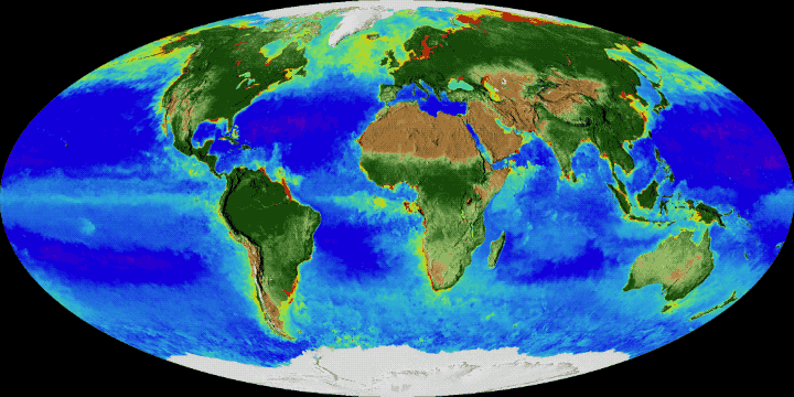
This article lists extreme locations on Earth that hold geographical records or are otherwise known for their geophysical or meteorological superlatives. All of these locations are Earth-wide extremes; extremes of individual continents or countries are not listed.
Latitude and longitude
Northernmost
- The northernmost point of land is the northern tip of Kaffeklubben Island, north of Greenland (), which lies slightly north of Cape Morris Jesup, Greenland (). Various shifting gravel bars lie farther north, the most famous being Oodaaq. There have been other islands more northern such as 83-42 and ATOW1996 but they have not been confirmed as permanent.
Southernmost
- The southernmost continental point of land outside Antarctica is in South America at Cape Froward, Magallanes Region, Chile ().
- The southernmost point of (liquid) water is a bay on the Filchner–Ronne Ice Shelf along the coast of Antarctica (), about 100 km south of Berkner Island.
- The southernmost point of ocean is located on the Gould Coast ().
- The southernmost point of open ocean is in the Bay of Whales, also part of the Ross Sea, at 78°30'S, at the edge of the Ross Ice Shelf.
- The southernmost island is considered to be Deverall Island, near the Shackleton Coast, surrounded by the Ross Ice Shelf although there is an island in Lake Vostok but it is currently under ice.
Easternmost and westernmost
- The easternmost and westernmost points on Earth, based on the east–west standard for describing longitude, can be found anywhere along the 180th meridian, which passes through the Arctic, Pacific, and Southern Oceans, as well as parts of Siberia (including Wrangel Island), Antarctica, and three islands of Fiji (Vanua Levu's eastern peninsula, the middle of Taveuni, and the western part of Rabi Island).
- Using instead the path of the International Date Line (which is not a straight line), i.e. define "easternmost" as "the first to see a new day" and define "westernmost" as "the last to see a new day", the westernmost point on land is Attu Island, Alaska, and the easternmost point on land is Caroline Island, Kiribati.
Longest grid lines
Along constant latitude
- The longest continuous east–west distance on land is 10726 km along the latitude 48°24'53"N, from the west coast of France (Pointe de Corsen, ) through Central Europe, Ukraine, Russia, Kazakhstan, Mongolia and China, to a point on the east coast of Russia ().
- The longest continuous east–west distance at sea is 22471 km along the latitude 55°59'S, south of Cape Horn, South America.
- The longest continuous east–west distance at sea between two continents is 15409 km along the latitude 18°39'12"N, from the coast of Hainan, China () across the Pacific Ocean to the coast of Michoacán, Mexico ().
Along constant longitude
- The longest continuous north–south distance on land is 7590 km along the meridian 99°1'30"E, from the northern tip of Siberia in the Russian Federation (), through Mongolia, China, and Myanmar, to a point on the south coast of Thailand ().
- The longest in Africa is 7417 km along the meridian 20°12'E, from the north coast of Libya (), through Chad, Central African Republic, Democratic Republic of the Congo, Angola, Namibia, and Botswana, to the south coast of South Africa ().
- The longest in South America is the length 7098 km along the meridian 70°2'W, from the north coast of Venezuela (), through Colombia, Ecuador, Peru, and Chile, to the southern tip of Argentina ().
- The longest in North America is 5813 km along the meridian 97°52'30"W, from northern Canada (), through the United States, to southern Mexico ().
- The longest continuous north–south distance at sea is 15986 km along the meridian 34°45'45"W, from the coast of Eastern Greenland () across the Atlantic Ocean to the Filchner-Ronne Ice Shelf, on the coast of Antarctica (). The longest in the Pacific Ocean is 15883 km along the meridian 172°8'30"W, from the coast of Siberia () to the Ross Ice Shelf in Antarctica ().
- The meridian that crosses the greatest total distance on land (disregarding intervening bodies of water) is still to be determined. It is likely located in the vicinity of 22°E, which is the longest integer meridian that fits that criterion, crossing a total of 13035 km of land through Europe (3370 km), Africa (7458 km), and Antarctica (2207 km). More than 65% of this meridian's length is located on land. The next six longest integer meridians by total distance over land are, in order:
- 23°E: 12953 km through Europe (3325 km), Africa (7415 km), and Antarctica (2214 km)
- 27°E: 12943 km through Europe (3254 km), Asia (246 km), Africa (7223 km), and Antarctica (2221 km)
- 25°E: 12875 km through Europe (3344 km), Africa (7327 km), and Antarctica (2204 km)
- 26°E: 12858 km through Europe (3404 km), Africa (7258 km), and Antarctica (2196 km)
- 24°E: 12794 km through Europe (3263 km), Africa (7346 km), and Antarctica (2185 km)
- 28°E: 12778 km through Europe (3039 km), Asia (388 km), and Africa (7117 km)
Along any geodesic
These are the longest straight lines that can be drawn between any two points on the surface of the Earth and remain exclusively over land or water; the points need not lie on the same line of latitude or longitude.
- The longest continuous straight-line (great circle) path over land is 13588 km long and spans between the West African coast near Greenville, Liberia () and a peninsula about 100 km northeast of Wenzhou, China (), passing over the Suez Canal.
- The longest continuous straight-line land distance solely within continental Africa is 8,402 km, along a line that begins just east of Tangier, Morocco, and ends 100 km east of Port Elizabeth, South Africa. This line passes through Morocco, Algeria, Mali, Niger, Nigeria, Cameroon, Equatorial Guinea, Gabon, Republic of the Congo, Democratic Republic of the Congo, Angola, Namibia, Botswana, and South Africa.
- The longest continuous straight-line land distance solely within continental Asia is 10,152 km, along a line that begins on the Indian coast near Kanyakumari and ends at the Bering Sea coast of the Chukchi Peninsula in Russia. This line passes through India, Nepal, China, Mongolia, and Russia.
- The longest continuous straight-line land distance solely within continental Europe (defining the Ural Mountains as the border between Europe and Asia) is 5,325 km, along a line that begins at Cape St. Vincent, Portugal, and ends at the Urals, near the town of Perm, Russia. This line passes through Portugal, Spain, France, Germany, Poland, Lithuania, Belarus, and Russia.
- The longest continuous straight-line land distance solely within continental North America is 7,602 km, along a line that begins at Point Hope, Alaska, United States, and ends 34 km southwest of the town of Salina Cruz, Mexico. This line passes through Alaska, Canada, the contiguous United States, and Mexico.
- The longest continuous straight-line land distance solely within continental South America is 7,248 km, along a line that begins 10 km northeast of Puerto Cumarebo, Venezuela, and ends 80 km south of the town of Punta Arenas, Chile. This line passes through Venezuela, Colombia, Brazil, Peru, Chile, and Argentina.
- The longest continuous straight-line land distance solely within continental Australia is 4,026 km, along a line that begins at the southern end of Cape Range National Park in Western Australia and ends at the town of Byron Bay in New South Wales.
- There are several possible candidates for the longest continuous straight-line distance in any direction at sea, as there are many possible ways to travel along a great circle for more than the antipodic length of 19840 km. Some examples of such routes would be:
- From the south coast of Balochistan province somewhere near Port of Karachi, Pakistan () across the Arabian Sea, southwest through the Indian Ocean, near Comoros, passing Namaete Canyon, near the South African coast, across the South Atlantic Ocean, then west across Cape Horn, then northwest across the Pacific Ocean, near Easter Island, passing the antipodal point near Emlilia island, through the South Bering Sea and ending somewhere on the northeast coast of Kamchatka, near Ossora (). This route is 32040 km long. This route was confirmed to be the longest (at about 32090 km) given map data at a 1.8 km level of resolution.
- From the south coast of Hormozgan province, Iran () across the Gulf of Oman, southeast across the Arabian Sea, passing south of Australia and New Zealand, near the Antarctic coast, then northeast across the South Pacific Ocean, passing the antipodal point and ending on the southwest coast of Mexico somewhere near Ciudad Lázaro Cárdenas (). This route is 25267 km long.
- From Invercargill, New Zealand () across Cape Horn, then off the coast of Brazil close to Recife, passing north of Cape Verde, passing the antipodal point and ending somewhere on the southwest coast of Ireland (). This route is 20701 km long.
Along any diameter (straight line passing through the centre of the Earth)
As distinct from geodesic lines, which appear straight only when projected onto the spheroidal surface of the Earth (i.e. arcs of great circles), straight lines passing through the Earth's centre can be constructed through the interior of the Earth between almost any two points on the surface of the Earth (some extreme topographical situations such as overhanging cliffs being the rare exceptions). A line projected from the summit of Cayambe in Ecuador (see highest points) through the axial centre of the Earth to its antipode on the island of Sumatra results in the longest diameter that can be produced anywhere through the Earth. As the variable circumference of the Earth approaches 25000 mi, such a maximum "diameter" or "antipodal" line would be on the order of 8000 mi long.
Elevation
Highest points
- The highest point on Earth's surface measured from sea level is the summit of Mount Everest, on the border of Nepal and China. While measurements of its height vary slightly, the elevation of its peak was most recently established in 2020 by the Nepali and Chinese authorities as 8848.86 m above sea level. The summit was first reached probably by Sir Edmund Hillary of New Zealand and Tenzing Norgay Sherpa of Nepal in 1953.
- The point farthest from Earth's centre is the summit of Chimborazo in Ecuador, at 6384.4 km from Earth's centre; the peak's elevation relative to sea level is 6263.47 m. Because Earth is an oblate spheroid rather than a perfect sphere, it is wider at the equator and narrower toward each pole. Therefore, the summit of Chimborazo, which is near the Equator, is farther away from Earth's centre than the summit of Mount Everest is; the latter is 2168 m closer, at 6382.3 km from Earth's centre. Peru's Huascarán (at 6768 m) contends closely with Chimborazo, though the former is a mere 10 m closer to the Earth's centre.
- The fastest point on Earth or, in other words, the point farthest from Earth's rotational axis is the summit of Cayambe in Ecuador, which rotates around Earth's axis at a speed of 1675.89 km/h and is 6383.95 km from the axis. Like Chimborazo, which is the fourth-fastest peak at 1675.47 km/h, Cayambe is close to the Equator and takes advantage of the oblate spheroid figure of Earth. More important, however, Cayambe's proximity to the Equator means that the majority of its distance from the Earth's centre contributes to Cayambe's distance from the Earth's axis.
Highest geographical features
- The highest volcano is Ojos del Salado on the Argentina–Chile border. It has the highest summit, 6893 m, of any volcano on Earth.
- The highest natural lake is an unnamed crater lake on Ojos del Salado at 6390 m, on the Argentina side. Another candidate was Lhagba Pool on the northeast slopes of Mount Everest, Tibet, at an elevation of 6368 m, which has since dried up.
- The highest navigable lake is Lake Titicaca, on the border of Bolivia and Peru in the Andes, at 3812 m.
- The highest glacier is the Khumbu Glacier on the southwest slopes of Mount Everest in Nepal, beginning on the west side of Lhotse at an elevation of 7600 to.
- The highest river is disputed; one candidate from many possibilities is the Ating Ho, which flows into the Aong Tso (Hagung Tso), a large lake in Tibet, and has an elevation of about 6100 m at its source at . Another very large and high river is the Yarlung Tsangpo or upper Brahmaputra River in Tibet, whose main stem, the Maquan River, has its source at about 6020 m above sea level at . Above these elevations, there are no constantly flowing rivers since the temperature is almost always below freezing.
- The highest island is one of a number of islands in the Orba Co lake in Tibet, at an elevation of 5209 m.
Highest points attainable by transportation
- The highest point accessible
- by land vehicle is an elevation of 6688 m on Ojos del Salado in Chile, which was reached by the Chilean duo of Gonzalo and Eduardo Canales Moya on 21 April 2007 with a modified Suzuki Samurai, setting the high-altitude record for a four-wheeled vehicle.
- by road (dead end) is on a mining road to the summit of Aucanquilcha in Chile, which reaches an elevation of 6176 m. It was once usable by 20-tonne mining trucks. The road is no longer usable.
- by road (mountain pass) is disputed; there are a number of competing claims for this title due to the definition of "motorable pass" (i.e. a surfaced road or one simply passable by a vehicle):
- The highest asphalted road is the single-lane road to Umling La, located 17 km west of Demchok in Ladakh, India, which reaches 5800 m ("19,300 feet" according to a Border Roads Organisation sign there that recognizes it as the "World's Highest Motorable Pass"). Before the asphalting of the road over Umling La, the highest asphalted road was Tibet's Semo La pass at 5565 m. It is used by trucks and buses regularly. The Ticlio pass, on the Central Road of Peru, is the highest surfaced road in the Americas, at an elevation of 4818 m.
- The highest unsurfaced road has several different claimants. All are unsurfaced or gravel roads including Mana Pass, between India and Tibet, which is crossed by a gravel road reaching 5610 m. The heavily trafficked Khardung La in Ladakh lies at 5359 m. A possibly motorable gravel road crosses Marsimik La in Ladakh at 5582 m.
- by train is Tanggula Pass, located on the Qinghai–Tibet (Qingzang) Railway in the Tanggula Mountains of Qinghai/Tibet, China, at 5072 m. The Tanggula railway station is the world's highest railway station at 5068 m. Before the Qingzang Railway was built, the highest railway ran between Lima and Huancayo in Peru, reaching 4829 m at Ticlio.
- by oceangoing vessel is a segment of the Rhine–Main–Danube Canal between the Hilpoltstein and Bachhausen locks in Bavaria, Germany. The locks artificially raise the surface level of the water in the canal to 406 m above mean sea level, higher than any other lock system in the world, making it the highest point currently accessible by oceangoing commercial watercraft.
- The highest commercial airport is Daocheng Yading Airport, Sichuan, China, at 4411 m. The proposed Nagqu Dagring Airport in Tibet, if built, will be 25 m higher at 4436 m.
- The highest helipad is Sonam, Siachen Glacier, India, at a height of 6400 m above sea level.
- The highest permanent human settlement is La Rinconada, Peru, 5100 m, in the Peruvian Andes.
- The farthest road from the Earth's centre is the Road to Carrel Hut in the Ecuadorian Andes, at an elevation of 4850 m above sea level and a distance of 6382.9 km from the centre of the Earth.
Lowest points
Lowest natural points
- The deepest point below the ocean's atmospheric surface is Challenger Deep, at the bottom of the Mariana Trench, 11034 m below sea level. Jacques Piccard and U.S. Navy Lieutenant Don Walsh first reached Challenger Deep in 1960 aboard the bathyscaphe Trieste, followed by filmmaker James Cameron in 2012 aboard Deepsea Challenger. Between 2020 and 2022, DSV Limiting Factor made 19 dives to Challenger Deep, carrying with it 19 further visitors.
- The deepest known cave is in the Krubera Cave in Abkhazia, with its deepest known point 2,199 ± 20 metres (7,215 ± 66 ft) below its entrance. The record was set in 2006, and it remains one of only two known caves deeper than 2,000 meters.
- The lowest point on land not covered by liquid water is the canyon under Denman Glacier in Antarctica, with the bedrock being 3,500 m below sea level.
- The lowest point on dry land is the shore of the Dead Sea, shared by Israel, Palestine and Jordan, 432.65 m below sea level. As the Dead Sea waters are receding, the water surface level drops more than 1 m per year.
- The point on the atmospheric surface closest to the Earth's centre (interpreted as a natural surface of the land or sea that is accessible by a person) is the surface of the Arctic Ocean at the Geographic North Pole (6356.77 km).
- The point on the surface of Earth's crust closest to the Earth's centre (interpreted as a land surface or sea floor) is the bottom of Litke Deep, in the Arctic Ocean, at 6,351.7043 km from Earth's centre; the deep's depth relative to sea level is 5,449 m. Because Earth is an oblate spheroid rather than a perfect sphere, it is wider at the equator and narrower toward each pole. Therefore, the bottom of Litke Deep, which is near the North Pole, is closer to Earth's centre than the bottom of Challenger Deep is; the latter is 14.7268 km further, at 6,366.4311 km from Earth's centre. Molloy Deep, also in Arctic Ocean (at 6,357.5178 km) from Earth's centre contends closely with Litke Deep, the difference from Earth's centre being just 389 m.
- The point on the ocean surface farthest below sea level is located in the Indian Ocean, about 1200 km southwest of India, the Indian Ocean Geoid Low, about 106 m below the global mean sea level.
Lowest artificial points
- The lowest point underground ever reached was 12262 m deep (SG-3 at the Kola Superdeep Borehole, which has since been enclosed).
- The lowest human-sized point underground is 3900 m below ground at the TauTona Mine, Carletonville, South Africa.
- The lowest (from sea level) artificially made point with open sky may be the Hambach surface mine, Germany, which reaches a depth of 293 m below sea level.
- The lowest (from surface) artificially made point with open sky may be the Bingham Canyon Open Pit Copper Mine, Utah, United States, at a depth of 1200 m below surface level.
- The lowest point underwater is the 10685 m-deep (as measured from the subsea wellhead) oil and gas well drilled on the Tiber Oil Field in the Gulf of Mexico. The wellhead of this well is an additional 1259 m underwater, for a total distance of 11944 m as measured from sea level.
Lowest points attainable by transportation
- The lowest point accessible:
- by road, excluding roads in mines, is any of the roads alongside the Dead Sea in Israel, Palestine and Jordan, which are the lowest on Earth at 418 m below sea level.
- The lowest undersea highway tunnel is the Ryfast tunnel in Norway, at 292 m below sea level.
- by train, excluding tracks in mines, is located in the Seikan Tunnel in Japan, at 240 m below sea level. For comparison, the undersea Channel Tunnel between the UK and France reaches a depth of 115 m below sea level.
- by ship, is located in the Indian Ocean, about 1200 km southwest of India, the Indian Ocean Geoid Low, about 106 m below the global mean sea level.
- Some mines have roads accessible from outside or rail tracks, located more than two thousand metres below sea level, for example in some South African gold mines.
- by road, excluding roads in mines, is any of the roads alongside the Dead Sea in Israel, Palestine and Jordan, which are the lowest on Earth at 418 m below sea level.
- The lowest railroad station was formerly the Japanese Yoshioka-Kaitei Station, at 150 m below sea level, but it closed in 2014. The lowest railroad station not inside a tunnel is 120 m below sea level, at Beit She'an railway station in Israel.
- The lowest airfield is the Bar Yehuda Airfield, near Masada, Israel, at 378 m below sea level.
- The lowest international airport is Atyrau Airport, near Atyrau, Kazakhstan, at 22 m below sea level, in the basin of the Caspian Sea.
- The lowest major city is Baku, Azerbaijan, located 28 m below sea level, which makes it the lowest-lying national capital in the world and also the largest city in the world located below sea level.
Table of extreme elevations and air temperatures by continent
Humans and biogeography
In contrast to places with the highest density of life, like terrestrial tropical regions, and beside local extreme conditions, which might only be overcome by extremophiles, there are areas of extreme low amounts of life.
Next to terrestrial lifeless areas like the Antarctic desert's McMurdo Dry Valleys and its Don Juan Pond, the most lifeless area in the ocean studied (other than the more general dead zones) is the South Pacific Gyre, corresponding to the oceanic pole of inaccessibility.
The oceanic pole of inaccessibility is also the antipodal area of the human center of population which lies today around southern Central Asia. Similarly the world's economic center of gravity has been drifting since antiquity from Central Asia to Northern Europe and contemporarily back to Central Asia. The related centre of gravity of the worlds carbon emission has shifted from Britain during the Industrial Revolution to the Atlantic, back again and contemporarily into Central Asia.
Remoteness
Poles of inaccessibility
Main article: Pole of inaccessibility
Each continent has its own continental pole of inaccessibility, defined as the place on the continent that is farthest from any ocean. Similarly, each ocean has its own oceanic pole of inaccessibility, defined as the place in the ocean that is farthest from any land.
Continental
- The most distant point from an ocean is the Eurasian Pole of Inaccessibility (or "EPIA") , in China's Xinjiang region near the border with Kazakhstan. Calculations have shown that this point, located in the Dzoosotoyn Elisen Desert, is 2645 km from the nearest coastline. The nearest settlement to the EPIA is Suluk at , about 11 km to the east. A 2007 study suggests that the historical calculation of the EPIA failed to recognize the point where the Gulf of Ob joins the Arctic Ocean, and proposes instead that varying definitions of coastline could result in other locations for the EPIA:
- EPIA1, somewhere between and , is about 2510 +/- from the nearest ocean.
- EPIA2, somewhere between and , is about 2514 +/- from the nearest ocean. :If adopted, this would place the final EPIA roughly 130 km closer to the ocean than the point that is currently agreed upon. Coincidentally, EPIA1, or EPIA2, and the most remote of the Oceanic Pole of Inaccessibility (specifically, the point in the South Pacific Ocean that is farthest from land) are similarly remote; EPIA1 is less than 200 km closer to the ocean than the Oceanic Pole of Inaccessibility is to land.
- The continental poles of inaccessibility for the other continents are as follows:
- Africa: , close to the tripoint of the Central African Republic, South Sudan, and the Democratic Republic of the Congo
- Australia: either , or , near Papunya, Northern Territory
- North America: , between Kyle, South Dakota and Allen, South Dakota, United States.
- South America: , near Arenápolis, Mato Grosso, Brazil
Oceanic
- The most distant point from land is the Pacific pole of inaccessibility (also called "Point Nemo", in a region known as the spacecraft cemetery), which lies in the South Pacific Ocean at , about 2688 km from the nearest land (equidistant from Ducie Island in the Pitcairn Islands to the north, Motu Nui off Rapa Nui to the northeast, and Maher Island off Siple Island near Marie Byrd Land, Antarctica, to the south). The centre of the Pacific Ocean and the Water Hemisphere lie west to it, closer to Oceania, off the coast of Kiribati at and New Zealand at respectively.
Other places considered the most remote
- The most remote island is Bouvet Island, a small, uninhabited island in the South Atlantic Ocean that is a dependency of Norway. It lies at coordinates . The nearest land is the uninhabited Queen Maud Land, Antarctica (also claimed by Norway), over 1600 km to the south. The nearest inhabited lands are Gough Island, 1845 km away, Tristan da Cunha, 2260 km away, and the coast of South Africa, 2580 km away.
- The title for most remote inhabited island or archipelago (the farthest away from any other permanently inhabited place) depends on how the question is interpreted. If the south Atlantic island Tristan da Cunha (population about 300) and its dependency Gough Island (with a small staffed research post), which are 399 km from each other, are considered part of the same archipelago, or if Gough Island is not counted because it has no permanent residents, then Tristan da Cunha is the world's most remote inhabited island/archipelago: the main island, also called Tristan da Cunha, is 2434 km from the island Saint Helena, 2816 km from South Africa, and 3360 km from South America. It is 2260 km away from uninhabited Bouvet Island. However, if Gough and Tristan da Cunha are considered separately, they disqualify each other, and the most remote inhabited island is Easter Island in the South Pacific Ocean, which lies 2075 km from Pitcairn Island (about 50 residents in 2013), 2606 km from Rikitea on the island of Mangareva (the nearest town with a population over 500), and 3512 km from the coast of Chile (the nearest continental point and the country of which Easter Island is part). The Kerguelen Islands in the southern Indian Ocean are another contender, lying 1340 km from the small Alfred Faure scientific station in Île de la Possession, but otherwise more than 3300 km from the coast of Madagascar (the nearest permanently inhabited place), 450 km northwest of the uninhabited Heard Island and McDonald Islands (both a part of Australia), and 1440 km from the non-permanent scientific station located in Île Amsterdam.
- Remote cities
- The most remote city with a population in excess of one million from the nearest city with a population in excess of one million is Auckland, New Zealand. The nearest city of comparable size or greater is Sydney, Australia, 2168.9 km away.
- The most remote city with a population in excess of one million from the nearest city with a population above 100,000 is Perth, Australia, located 2138 km away from Adelaide, Australia.
- The most remote city with a population in excess of 100,000 from the nearest city with a population in excess of 100,000 is Honolulu, Hawaii, United States. The nearest city of comparable size or greater is San Francisco, 3850 km away.
- The most remote national capitals are Wellington, New Zealand, and Canberra, Australia, which are 2326 km apart from each other and neither is closer to another capital.
- The most remote airport in the world from another airport is Mataveri International Airport (IPC) on Easter Island, which has a single runway for military and public use. It is located 2603 km from Totegegie Airport (GMR; very few flights) in the Gambier Islands, French Polynesia and 3759 km from Santiago, Chile (SCL; a fairly large airport). In comparison, the airport at the Amundsen–Scott South Pole Station (NZSP) is far less remote, being located only 1355 km from Williams Field (NZWD) near Ross Island.
Centre
Main article: Geographical center of Earth
Since the Earth is a spheroid, its centre (the core) is thousands of kilometres beneath its crust. Still, there have been attempts to define various "centrepoints" on the Earth's surface.
- The centre of the standard geographic model as viewed on a traditional world map is the point 0°, 0° (the coordinates of zero degrees latitude by zero degrees longitude), which is located in the Atlantic Ocean about 614 km south of Accra, Ghana, in the Gulf of Guinea. It lies at the intersection of the Equator and the Prime Meridian, is marked with a buoy, and is sometimes called Null Island. However, the selection of the Prime Meridian as the 0° longitude meridian depended on cultural and historical factors and is therefore geographically arbitrary (any of the Earth's meridians could, in principle, be defined as 0° longitude); consequently, the position of the "Null Island" centrepoint is also arbitrary.
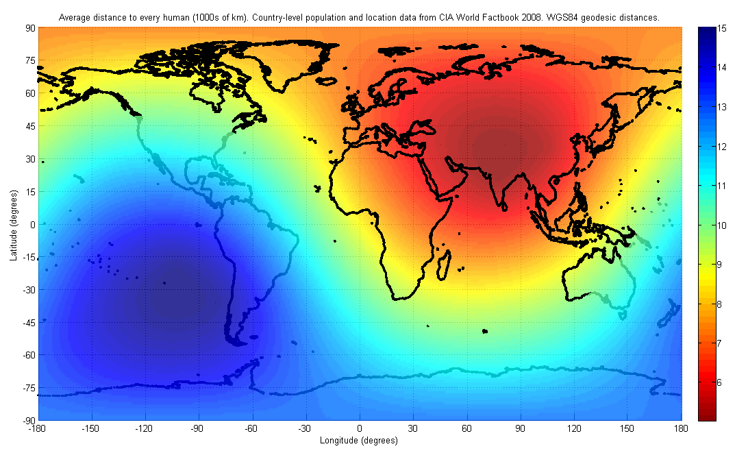
- The centre of population, the place to which there is the shortest average route for every individual human being in the world, could also be considered a "centre of the world". This point is located in the north of the Indian subcontinent, although the precise location has never been calculated and is constantly shifting due to changes in the distribution of the human population across the planet.
Geophysical extremes
Tallest mountain
- Mount Everest, the highest point above Earth's sea level, measuring 8,848.86 m (29,031.7 ft).
- Mauna Kea, tallest mountain from base-to-peak, with a dry prominence of 9330 m and a wet prominence above sea level of 4,207.3 m.
- Mount Denali, tallest mountain from base-to-peak on land, measuring 5500 meter.
Greatest vertical drop
| Greatest ocean cliff | Kermadec Trench, with cliffs around 8000 m tall | [[File:Kermadec Arc.jpg | right | 100px]] |
|---|
Longest
- Great Escarpment, South Africa is the longest surface escarpment at 5,000 km long
Subterranean
| Highest surveyed cave | 4930 m |
|---|---|
Five longest surveyed
| Sistema Ox Bel Ha, Mexico | last = Owen | first = James | title = World's Biggest Cave Found in Vietnam | work = National Geographic News | publisher = National Geographic Society | date = 2009-07-04 | url = http://news.nationalgeographic.com/news/2009/07/090724-biggest-cave-vietnam.html | archive-url = https://web.archive.org/web/20090727132344/http://news.nationalgeographic.com/news/2009/07/090724-biggest-cave-vietnam.html | url-status = dead | archive-date = July 27, 2009 | access-date =2009-07-29}} |
|---|
Five longest surveyed caves
- Mammoth Cave, Kentucky, US
- Sistema Ox Bel Ha, Mexico
- Sistema Sac Actun/Sistema Dos Ojos, Mexico
- Jewel Cave, South Dakota, US
- Shuanghedong Cave Network, China
| Deepest borehole by depth below sea level | 11944 m (10,685 m well at 1,259 m deep seabed) |
|---|---|
| The Tiber well, Gulf of Mexico, United States |
Greatest oceanic depths
| Southern Ocean | 7433.6 m |
|---|---|
| South Sandwich Trench (southernmost portion, at ) |
Deepest ice
Ice sheets on land, but having the base below sea level. Places under ice are not considered to be on land.
| Trough beneath Jakobshavn Isbræ | -1512 m | Greenland, Denmark |
|---|
Meteorological extremes
Coldest and hottest inhabited places on Earth
| The South Pole and some other places in Antarctica are colder and are populated year-round, but almost everyone stays less than a year and could be considered visitors, not inhabitants. |
|---|
Ground temperatures
Temperatures measured directly on the ground may exceed air temperatures by 30 to 50 °C. A ground temperature of 84 °C (183.2 °F) has been recorded in Port Sudan, Sudan. A ground temperature of 93.9 °C (201 °F) was recorded in Furnace Creek, Death Valley, California, United States on 15 July 1972; this may be the highest natural ground surface temperature ever recorded. The theoretical maximum possible ground surface temperature has been estimated to be between 90 and 100 °C for dry, darkish soils of low thermal conductivity.
Satellite measurements of ground temperature taken between 2003 and 2009, taken with the MODIS infrared spectroradiometer on the Aqua satellite, found a maximum temperature of 70.7 °C (159.3 °F), which was recorded in 2005 in the Lut Desert, Iran. The Lut Desert was also found to have the highest maximum temperature in 5 of the 7 years measured (2004, 2005, 2006, 2007 and 2009). These measurements reflect averages over a large region and so are lower than the maximum point surface temperature.
Satellite measurements of the surface temperature of Antarctica, taken between 1982 and 2013, found a coldest temperature of −93.2 °C (−136 °F) on 10 August 2010, at . Although this is not comparable to an air temperature, it is believed that the air temperature at this location would have been lower than the official record lowest air temperature of −89.2 °C.
Extreme points by region
Afro-Eurasia
- Extreme points of Afro-Eurasia
- Africa
- ::{{hlist|Algeria | Angola | Benin | Botswana | Burkina Faso | Burundi | Cameroon | Cape Verde | Central African Republic | Chad | Comoros | Democratic Republic of the Congo | Republic of Congo | Côte d'Ivoire | Djibouti | Egypt | Equatorial Guinea | Eritrea | Ethiopia | Gabon | Gambia | Ghana | Guinea | Guinea-Bissau | Kenya | Lesotho | Liberia | Libya | Madagascar | Malawi | Mali | Mauritania | Mauritius | Morocco | Mozambique | Namibia | Niger | Nigeria | Rwanda | São Tomé and Príncipe | Senegal | Seychelles | Sierra Leone | Somalia | South Africa | Sudan | South Sudan | Swaziland | Tanzania | Togo | Tunisia | Uganda | Western Sahara | Zambia | Zimbabwe}}
- Eurasia
- Asia
- :{{hlist| Afghanistan | Armenia | Azerbaijan | Bangladesh | Bhutan | Cambodia | China | Georgia | India | Indonesia | Iran | Israel | Japan | Jordan | Kazakhstan | Kyrgyzstan | Laos | Malaysia | Maldives | Mongolia | Myanmar | Nepal | North Korea | Pakistan | Philippines | Russia | Singapore | South Korea | Sri Lanka | Taiwan | Tajikistan | Thailand | Turkmenistan | Uzbekistan | Vietnam }}
- Europe
- : {{hlist| European Union | Albania | Andorra | Austria | Belarus | Belgium | Bosnia and Herzegovina | Bulgaria | Croatia | Czech Republic | Denmark | Estonia | Finland | France | Germany | Greece | Hungary | Iceland | Ireland | Italy | Kosovo | Latvia | Liechtenstein | Lithuania | Luxembourg | Malta | Moldova | Monaco | Montenegro | Netherlands | North Macedonia | Norway | Poland | Portugal | Romania | Russia | San Marino | Serbia | Slovakia | Slovenia | Spain | Sweden | Switzerland | Turkey | Ukraine | United Kingdom | Vatican City }}
The Americas
- Extreme points of the Americas
- North America
- ::{{hlist| Canada
--(provinces,
--communities)
| Greenland
| Mexico
| United States
--(states,
--New England) }}
- Central America
- : {{hlist| Belize | Costa Rica | El Salvador | Guatemala | Honduras | Nicaragua | Panama }}
- The Caribbean
- : {{hlist |Cuba | Dominican Republic | Jamaica }}
- South America
- :: {{hlist| Argentina | Bolivia | Brazil | Chile | Colombia | Ecuador | French Guiana | Guyana | Paraguay | Peru | Suriname | Uruguay | Venezuela }}
Oceania
- Extreme points of Oceania
- ::: {{hlist| Australia | Fiji | Guam | Indonesia | Kiribati | Marshall Islands | Micronesia | Nauru | New Zealand | Niue | the Northern Mariana Islands | Palau | Papua New Guinea | Tuvalu }}
Antarctica
- Extreme points of Antarctica
Arctic
- Extreme points of the Arctic
Notes
References
References
- [https://geonames.usgs.gov/apex/f?p=gnispq:5:0::NO::P5_ANTAR_ID:5881 Gould Coast] US Geographic Survey.
- "Bay of Whales - former bay, Antarctica". [[Encyclopædia Britannica]].
- Whitehouse, D. (25 May 2005). "Russia to resume Vostok drilling". BBC News.
- [http://www.gcmap.com/mapui?P=5%B02%26%238242%3B51.59%26%238243%3BN+9%B07%26%238242%3B23.26%26%238243%3BW+-+28%B017%26%238242%3B7.68%26%238243%3BN+121%B038%26%238242%3B17.31%26%238243%3BE%0D%0A&MS=bm&DU=mi (Map from gcmap)]
- [https://geodesyapps.ga.gov.au/distance (Geoscience Australia)]
- [http://www.gcmap.com/mapui?P=25%B025%27N+66%B025%27E+-+59%B038%27S+16%B036%27W+-+25%B025%27S+113%B035%27W+-+59%B038%27N+163%B024%27E%0D%0A (Map from gcmap)]
- (9 April 2018). "Longest Straight Line Paths on Water or Land on the Earth".
- David Shultz. (30 April 2018). "This ocean path will take you on the longest straight-line journey on Earth". Science Magazine.
- [http://www.gcmap.com/mapui?P=25%B035%27N+58%B022%27E+-+17%B057%27S+78%B003%27E+-+25%B035%27S+121%B038%27W+-+17%B057%27N+101%B057%27W (Map from gcmap)]
- [http://www.gcmap.com/mapui?P=46%B037%27S+168%B059%27E+-+52%B009%27S+173%B026%27E+-+46%B037%27N+11%B001%27W+-+52%B009%27N+6%B034%27W%0D%0A (Map from gcmap)]
- (9 February 2021). "Mount Everest is more than two feet taller, China and Nepal announce". nationalgeographib.com.
- "Highest Mountain in the World". geology.com.
- (7 April 2016). "Chimborazo, el volcán de Ecuador más alto que el Everest (si se mide desde el centro de la Tierra)". [[BBC Mundo]].
- "Distance to the Center of the Earth".
- "Andes Website – Information about Ojos del Salado volcano, a high mountain in South America and the world's highest volcano".
- "The Highest Lake in the World".
- "ASTER measurement of supraglacial lakes in the Mount Everest region of the Himalaya: ''The main Khumbu Glacier is about 17 km long with elevations ranging from 4900m at the terminus to 7600m at the source''....The 7600m to 8000m elevations are also depicted on numerous detailed topographic maps".
- "The Mystery of World's highest river and largest Canyon".
- "Island Superlatives".
- McIntyre, Loren. (April 1987). "The High Andes". National Geographic Society.
- (17 October 2017). "Battle for the Highest Motorable Road". Motoroids.
- "China Border {{!}} Umling La Pass [ World's Highest Motorable Road ] {{!}} Ep-26 {{!}} Tripura to Ladakh Ride".
- Assumpció Térmens. (20 March 2006). "ICC – Semo Khardung". Institut Cartogràfic de Catalunya.
- Bennett, Suzy. (October 2003). ["Destination Guides – World's highest railway, Peru – Wanderlust Travel Magazine"](http://www.wanderlust.co.uk/magazine/articles/destinations/a-train-journey-through-the-peruvian-andes). Wanderlust Magazine.
- Ben Blanchard. (16 September 2013). "China opens world's highest civilian airport". Reuters.
- (20 May 2002). "Siachen: The world's highest cold war". CNN.
- "Carrel refuge.". summitpost.org.
- "Challenger Deep – the Mariana Trench".
- "Deepest Submarine Dive in History, Five Deeps Expedition Conquers Challenger Deep". fivedeeps.com.
- Weinman, Steve. (2022-07-15). "Deep-sea mapper can't get much deeper! - Divernet".
- Dubliansky VN, Klimchuk AB, Kiselev VE, Vakhrushev BA, Kovalev YN, Melnikov VP, Ryzhkov AF, Tintilozov ZK, Chuykov VD, Churubrova ML. "Описания пещер массива Арабика - 63.Пещерная система Арабикская" [Descriptions of caves of the Arabika massif - 63.Arabikskaja cave system] (in Russian). Retrieved 2020-01-12.
- Jonathan Amos. (12 December 2019). "Denman Glacier: Deepest point on land found in Antarctica". [[BBC News.
- (12 December 2019). "Deep glacial troughs and stabilizing ridges unveiled beneath the margins of the Antarctic ice sheet". [[Nature Geoscience]].
- Connolly, Kevin. (17 June 2016). "Dead Sea drying: A new low-point for Earth". BBC.
- "''Revisiting "Ocean Depth closest to the Center of the Earth"''". Arjun Tan, Department of Physics, Alabama A & M University.
- (1 January 2009). "TauTona, Anglo Gold – Mining Technology". SPG Media Group PLC.
- "Transocean's Ultra-Deepwater Semisubmersible Rig Deepwater Horizon Drills World's Deepest Oil and Gas Well". Transocean.
- (January 2013). "High-resolution residual geoid and gravity anomaly data of the northern Indian Ocean – An input to geological understanding". Journal of Asian Earth Sciences.
- [http://wmo.asu.edu/ Global Weather & Climate Extremes] World Meteorological Organization
- The Kilimanjaro 2008 Precise Height Measurement Expedition. ''[http://www.fig.net/pub/fig2009/papers/ts08c/ts08c_fernandes_teamkili2008_3438.pdf Precise Determination of the Orthometric Height of Mt. Kilimanjaro]''
- Harter, Pascale. (4 December 2010). "A life of constant thirst beside Djibouti's Lake Assal". BBC News.
- {{cite gnis
- link. (5 July 2009 , Australian Antarctic Data Centre. Retrieved 15 January 2010.)
- (7 April 2007). "The 'Highest' Spot on Earth?".
- "Lowest Elevation: Dead Sea". Extremescience.com.
- Weather Underground - Christopher C. Burt - The Coldest Places on Earth https://www.wunderground.com/blog/weatherhistorian/the-coldest-places-on-earth
- (30 June 2017). "Temperatures in Iranian city of Ahvaz hit 129.2F (54C), near hottest on Earth in modern measurements". independent.com.
- (28 October 2010). "Life Is a Chilling Challenge in Subzero Siberia from the National Geographic". News.nationalgeographic.com.
- [http://peakbagger.com/peak.aspx?pid=10381 Mount Elbrus] at peakbagger.com
- (2009). "The Handy Geography Answer Book". Visible Ink Press.
- (2 September 2015). "New Elevation for Nation's Highest Peak". USGS.
- (21 September 2015). "USGS National Elevation Dataset (NED) 1 meter Downloadable Data Collection from The National Map 3D Elevation Program (3DEP) - National Geospatial Data Asset (NGDA) National Elevation Data Set (NED)". [[United States Geological Survey]].
- (10 July 2021). "Temperature reaches 130 °F (54.4 °C) at California's Death Valley".
- [http://www.peakbagger.com/peak.aspx?pid=11360 Carstensz Pyramid, Indonesia] at peakbagger.com
- "Oceaina". Worldatlas.com.
- (13 January 2022). "Australia equals hottest day on record at 50.7C". BBC News.
- [http://www.peakbagger.com/peak.aspx?pid=8594 Aconcagua, Argentina] at peakbagger.com
- (20 June 2013). "Lowest Points on Land". Geography.about.com.
- PWMU. "Ninety-year-old World temperature record in El Azizia (Libya) is invalid Improved data strengthens Climate knowledge". Wmo.int.
- [http://wmo.asu.edu/europe-highest-temperature Europe: Highest Temperature] {{webarchive. link. (29 June 2009 WMO)
- (9 January 1954). "Western Hemisphere: Lowest Temperature". Wmo.asu.edu.
- "WMO Region IV (North America): Lowest Temperature". Wmo.asu.edu.
- (24 December 2003). "Queensland to bake on Christmas Day". Australian Broadcasting Corporation.
- Trewin, Blair. (December 1997). "Another look at Australia's record high temperature". Australian Meteorological Magazine.
- (21 May 2018). "The biomass distribution on Earth". Proceedings of the National Academy of Sciences.
- D'Hondt, Steven. (July 2009). "Subseafloor Sediment In South Pacific Gyre One Of Least Inhabited Places On Earth". Proceedings of the National Academy of Sciences of the United States of America.
- (2014). "Model of Decision Support for Alternative Choice in the Large Scale Transportation Transit System". Unpublished.
- Kommenda, Niko. (13 October 2021). "UK, US, China: how the world's carbon 'centre of gravity' moved over 200 years".
- (September 2007). "Poles of inaccessibility: A calculation algorithm for the remotest places on earth".
- (2007). "Poles of Inaccessibility: A Calculation Algorithm for the Remotest Places on Earth". Informa UK.
- [http://www.ga.gov.au/education/facts/dimensions/centre.htm Centre of Australia, States and Territories] {{webarchive. link. (22 August 2008 , Geoscience Australia)
- [http://www.daftlogic.com/projects-google-maps-distance-calculator.htm Draft Logic – Google Maps Distance Calculator], accessed 4 September 2011
- "Flight Distance from Perth, Australia to Adelaide, Australia". travelmath.com.
- "The Most Isolated Cities of the World". cityextremes.com.
- "Great Circle Mapper". gcmap.com.
- Adam Helman. (2005). "The Finest Peaks: Prominence and Other Mountain Measures". Trafford Publishing.
- (9 March 2010). "Mount Thor -The Greatest Vertical Drop on Earth!". Dailygalaxy.com.
- {{cite bivouac
- "The Great Escarpment of Southern Africa: A New Frontier for Biodiversity Exploration".
- (2022-08-21). "World's Longest Caves List from The National Speleological Society".
- National Park Service. (September 8, 2022). "Mammoth Cave Just Got A Little More "Mammoth" - Mammoth Cave National Park (U.S. National Park Service)".
- (January 26, 2023). "CINDAQ 2022 Annual report". El Centro Investigador del Sistema Acuífero de Quintana Roo A.C.(CINDAQ).
- "Reports Archives".
- "World's Deepest Caves List from The National Speleological Society".
- "Iranian cavers discover one of the world's deepest shafts".
- (August 2022). "Hranice Abyss is believed to be 1200 m. deep (in Czech)".
- Vergano, Dan. (September 28, 2014). "China's "Supercave" Takes Title as World's Most Enormous Cavern". [[National Geographic Society]].
- Pumacocha 2004 Expedition Report
- National Park Service. (September 8, 2022). "Mammoth Cave Just Got A Little More "Mammoth" - Mammoth Cave National Park (U.S. National Park Service)".
- "Reports Archives".
- "Iranian cavers discover one of the world's deepest shafts".
- (August 2022). "Hranice Abyss is believed to be 1200 m. deep (in Czech)".
- Pumacocha 2004 Expedition Report
- (30 October 2008). "Climbers explore one of world's deepest underground shafts". Telegraph Media Group Limited.
- "Kola Superdeep Borehole".
- "BP Deepeater Well".
- "Atlantic Ocean".
- "Five Deeps Expedition is complete after historic dive to the bottom of the Arctic Ocean".
- "Deep sea pioneermakes history again as first human to dive to the deepest point in the Indian Ocean, the Java Trench".
- "Deepest Submarine Dive in History, Five Deeps Expedition Conquers Challenger Deep".
- (4 June 2009). "Daily Reports for R/V KILO MOANA June and July 2009". University of Hawaii Marine Center.
- "Explorer makes history as first human to successfully dive to the deepest point in the Southern Ocean, in the South Sandwich Trench".
- Plummer, Joel. [https://www.cresis.ku.edu/~plummer/jakob.html#Bed_1 Jakobshavn Bed Elevation] {{webarchive. link. (27 June 2010 , Center for the Remote Sensing of the Ice Sheets, Dept of Geography, University of Kansas.)
- p. 9, ''Weather Experiments'', Muriel Mandell and Dave Garbot, Sterling Publishing Company, Inc., 2006, {{ISBN. 1-4027-2157-9.
- Average of table on p. 26, ''Extreme Weather: A Guide & Record Book'', Christopher C. Burt and Mark Stroud, New York: W. W. Norton & Company, 2007, {{ISBN. 0-393-33015-X.
- (4 February 2013). "Canadian Climate Normals 1971-2000". Climate.weatheroffice.gc.ca.
- (2011). "Satellite Finds Highest Land Skin Temperatures on Earth". Bulletin of the American Meteorological Society.
- Table 9.2, p. 158, ''Dryland Climatology'', Sharon E. Nicholson, Cambridge University Press, 2011, {{ISBN. 1139500244.
- A possible world record maximum natural ground surface temperature, Paul Kubecka, ''Weather'', '''56''', #7 (July 2001), ''Weather'', pp. 218-221, {{doi. 10.1002/j.1477-8696.2001.tb06577.x.
- [http://journals.ametsoc.org/doi/abs/10.1175/1520-0450%281992%29031%3C1096%3AEMLST%3E2.0.CO%3B2 Extreme Maximum Land Surface Temperatures], J. R. Garratt, Journal of Applied Meteorology, '''31''', #9 (September 1992), pp. 1096–1105, {{doi. 10.1175/1520-0450(1992)031<1096:EMLST>2.0.CO;2.
- [https://www.bbc.com/news/science-environment-25287806 Coldest spot on Earth identified by satellite], Jonathan Amos, BBC News, 9 December 2013.
- [http://fallmeeting.agu.org/2013/files/2013/12/ColdestPlaceOnEarth.pdf The Coldest Place on Earth: -90°C and below from Landsat 8 and other satellite thermal sensors], Ted Scambos, Allen Pope, Garrett Campbell, and Terry Haran, [[American Geophysical Union]] fall meeting, 9 December 2013.
This article was imported from Wikipedia and is available under the Creative Commons Attribution-ShareAlike 4.0 License. Content has been adapted to SurfDoc format. Original contributors can be found on the article history page.
Ask Mako anything about Extremes on Earth — get instant answers, deeper analysis, and related topics.
Research with MakoFree with your Surf account
Create a free account to save articles, ask Mako questions, and organize your research.
Sign up freeThis content may have been generated or modified by AI. CloudSurf Software LLC is not responsible for the accuracy, completeness, or reliability of AI-generated content. Always verify important information from primary sources.
Report