From Surf Wiki (app.surf) — the open knowledge base
1982 Florida subtropical storm
Atlantic subtropical storm in 1982
Atlantic subtropical storm in 1982
| Field | Value |
|---|---|
| name | Subtropical Storm One |
| image | SS One 1982-06-18 1800Z.jpg |
| caption | Subtropical Storm One traveling up the Eastern Seaboard on June 18 |
| formed | June 18, 1982 |
| extratropical | June 20, 1982 |
| dissipated | June 22, 1982 |
The 1982 Florida subtropical storm, officially known as Subtropical Storm One, was the only subtropical cyclone of the exceptionally inactive 1982 Atlantic hurricane season. The storm originated from two different systems around the Gulf of Mexico and Caribbean on June 16. The systems merged into trough while a circulation began to form off the coast of Florida on June 18. The depression made landfall in Florida and strengthened into a storm over land. The storm entered the Atlantic Ocean and headed to the northeast, becoming extratropical on June 20 near Newfoundland. The storm was the only system of 1982 to affect the eastern half of the United States, and it caused three fatalities and caused $10 million in damage (1982 USD, $21 million 2007 USD).
Meteorological history
The subtropical storm had an unusual origin by forming from an interaction of two different systems near the Yucatán Peninsula. This occurrence is unusual, but not unique, as Subtropical Storm One in the 1974 season formed in similar pattern.{{ cite web | access-date=2007-03-28 cite web | access-date=2007-04-05
A circulation began to form on June 18 in the eastern Gulf of Mexico, prompting gale warnings.{{ cite web | access-date=2007-04-05 cite web | access-date=2007-12-08 cite web |author-link=Canadian Hurricane Centre |access-date=2007-03-28 |url-status=dead |archive-url=https://web.archive.org/web/20060513212951/http://www.atl.ec.gc.ca/weather/hurricane/storm82.html |archive-date=2006-05-13 cite web | access-date=2007-12-16
Preparations
Several warnings were issued in association with the subtropical storm.{{ cite web | access-date=2007-04-05
The subtropical storm postponed the bi-annual Newport, Rhode Island to Bermuda sailboat race for two consecutive days due to the forecast one of the storm. Subsequent reports from sailboats said that with the track of the storm, if not for the delay, there would have been a marine disaster.
Impact
In its main inflow band over Cuba, rainfall amounts up to 28.66 in were recorded.
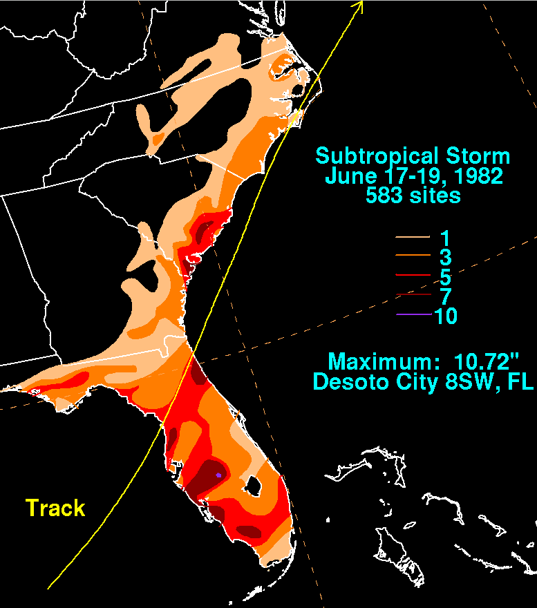
Most of the storm's effects were felt in Florida where it made landfall on the morning of June 18, causing gales, heavy rains, flooding, beach erosion and tornadoes. The highest winds were recorded at 41 mph and up to 48 mph during a thunderstorm at Macdill Air Force Base in Tampa on June 18. Rainfall peaked at 10.72 in in Desoto City, while much of the rest of the state reported between 1–5 inches (25–125 inches) of precipitation.{{ cite web | access-date=2007-03-28 cite web | access-date=2007-03-28 | author-link=David M. Roth
The subtropical storm spawned twelve tornadoes across Florida, including at least 2 tornadoes which reached a magnitude of F2 on the Fujita Scale. The first tornado formed in Hendry County on June 18 at 0115 UTC reaching F2 strength.{{ cite web | access-date=2007-03-28
The storm's effects north of Florida were minor. Rainfall reached up to 9 in in extreme eastern South Carolina and 4 in in eastern North Carolina. Winds reached 50 mph with gusts up to 66 mph at the Oak Island Coast Guard Station near Cape Fear, North Carolina and 54 mph with gusts of 77 mph at the offshore tower at Frying Pan Shoals about forty miles southeast of Cape Fear on June 18 with 70 mph winds (110 km/h) the next day. A 68-foot fishing trawler sunk off the coast of Cape Fear in North Carolina from the high waves; no one was killed as the sailors were rescued by the United States Coast Guard on June 19. Flooding was reported with tides of two to three feet in the Carolinas. Rainfall from the subtropical storm reached both states, reaching maximum peaks of up to 5 in on the Georgia coast and seven inches on the Georgia/South Carolina border. Rainfall totaled to about 1 in on the Virginian coast. A ship encountered winds of a minimum tropical storm with gusts as high as a maximum tropical storm. The ship also encountered a tidal surge of 15 to 20 feet.
References
References
- Instituto Nacional de Recursos Hidráulicos. (2003). "Lluvias intensas observadas y grandes inundaciones reportadas".
- Florida Department of Environmental Protection. (2003). "Strategic Beach Management Plan".
- Collier County, Florida. (2007). "Collier County Flood History". Collier County, Florida.
This article was imported from Wikipedia and is available under the Creative Commons Attribution-ShareAlike 4.0 License. Content has been adapted to SurfDoc format. Original contributors can be found on the article history page.
Ask Mako anything about 1982 Florida subtropical storm — get instant answers, deeper analysis, and related topics.
Research with MakoFree with your Surf account
Create a free account to save articles, ask Mako questions, and organize your research.
Sign up freeThis content may have been generated or modified by AI. CloudSurf Software LLC is not responsible for the accuracy, completeness, or reliability of AI-generated content. Always verify important information from primary sources.
Report