From Surf Wiki (app.surf) — the open knowledge base
West Indies
Island region in North Atlantic and Caribbean
Island region in North Atlantic and Caribbean
| Field | Value | |||||||||||||||||||
|---|---|---|---|---|---|---|---|---|---|---|---|---|---|---|---|---|---|---|---|---|
| title | West Indies | |||||||||||||||||||
| image | West Indies (orthographic projection).svg | |||||||||||||||||||
| area | 239,681 km2 | |||||||||||||||||||
| population | ||||||||||||||||||||
| density | 151.5 /km2 | |||||||||||||||||||
| ethnic_groups | Afro-Caribbean | |||||||||||||||||||
| Latin-Caribbean | ||||||||||||||||||||
| Indo-Caribbean | ||||||||||||||||||||
| White-Caribbean | ||||||||||||||||||||
| Mixed-Caribbean | ||||||||||||||||||||
| Asian-Caribbean | ||||||||||||||||||||
| Indigenous | ||||||||||||||||||||
| religions | {{ublist | item_style=white-space:nowrap; | ||||||||||||||||||
| 1.3% others<ref>{{cite journal | url | https://brill.com/view/journals/jrd/9/1-2/article-p91_2.xml | title=Religions by Continent | journal=Journal of Religion and Demography | last1=Johnson | first1=Todd M. | last2=Crossing | first2=Peter F. | volume=9 | date=14 October 2022 | issue=1–2 | pages=91–110 | doi=10.1163/2589742x-bja10013 | url-access=subscription}}}} | ||||||
| demonym | West Indian | |||||||||||||||||||
| Caribbean | ||||||||||||||||||||
| West Indy (colloquial) | ||||||||||||||||||||
| countries | {{Collapsible list | |||||||||||||||||||
| title | 13 | |||||||||||||||||||
| dependencies | {{Collapsible list | title = 18 | Anguilla (UK) | Aruba (Netherlands) | Bonaire (Netherlands) | British Virgin Islands (UK) | Cayman Islands (UK) | Curaçao (Netherlands) | Guadeloupe (France) | Martinique (France) | Montserrat (UK) | Haiti-Navassa Island (United States) and (Haiti) | Puerto Rico (United States) | Saba (Netherlands) | Saint Barthélemy (France) | Local flag of the Collectivity of Saint Martin.svg Saint Martin (France) | Sint Eustatius (Netherlands) | Sint Maarten (Netherlands) | Turks and Caicos Islands (UK) | US Virgin Islands (United States) |
| languages | {{Plainlist | |||||||||||||||||||
| time | UTC−05:00 to UTC−04:00 | |||||||||||||||||||
| internet | Multiple | |||||||||||||||||||
| calling_code | Multiple | |||||||||||||||||||
| cities | Santo Domingo | |||||||||||||||||||
| Havana | ||||||||||||||||||||
| Port-au-Prince | ||||||||||||||||||||
| San Juan | ||||||||||||||||||||
| Port of Spain | ||||||||||||||||||||
| Kingston | ||||||||||||||||||||
| Santiago de Cuba | ||||||||||||||||||||
| Santiago de los Caballeros | ||||||||||||||||||||
| Nassau | ||||||||||||||||||||
| Camagüey | ||||||||||||||||||||
| Cap-Haïtien | ||||||||||||||||||||
| m49 | `029` – Caribbean | |||||||||||||||||||
| `419` – Latin America | ||||||||||||||||||||
| `019` – Americas | ||||||||||||||||||||
| `001` – World |
the island region in the Caribbean and North Atlantic Ocean
Latin-Caribbean Indo-Caribbean White-Caribbean Mixed-Caribbean Asian-Caribbean Indigenous |
- 73.5% Christianity
- 52.3% Catholicism
- 20.2% Protestantism
- 1.0% other Christian |20.6% no religion |2.5% folk religions |2.1% Hinduism |1.3% others}} Caribbean West Indy (colloquial) | Antigua and Barbuda | The Bahamas | Barbados | Cuba | Dominica | Dominican Republic | Grenada | Haiti | Jamaica | Saint Kitts and Nevis | Saint Lucia | Saint Vincent and the Grenadines | Trinidad and Tobago
- English
- Spanish
- French
- Dutch
- French Creoles
- English Creoles
- Dutch Creoles
- Spanish Creoles
- Papiamento
- Caribbean Hindustani
- Indigenous languages}}
Havana
Port-au-Prince
San Juan
Port of Spain
Kingston
Santiago de Cuba
Santiago de los Caballeros
Nassau
Camagüey
Cap-Haïtien
419– Latin America019– Americas001– World
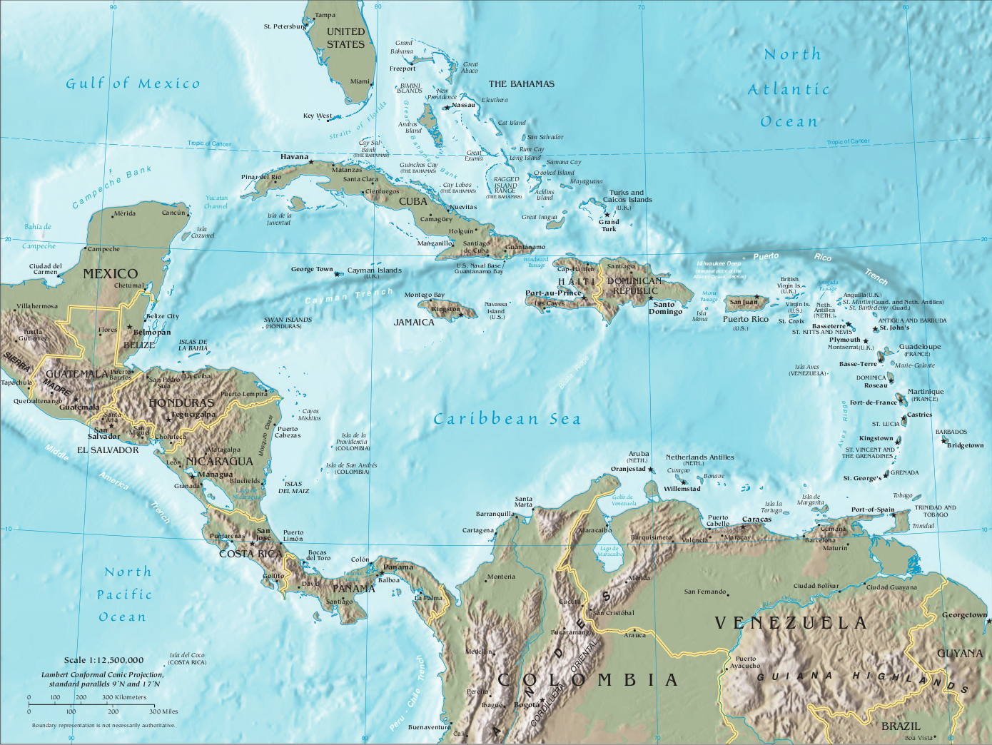
The West Indies are an island subregion of the Americas, surrounded by the North Atlantic Ocean and the Caribbean Sea, which comprises 13 independent island countries and 18 dependencies in three archipelagos: the Greater Antilles, the Lesser Antilles, and the Lucayan Archipelago.
The subregion includes all the islands in the Antilles, in addition to The Bahamas and the Turks and Caicos Islands, which are in the North Atlantic Ocean. The term is often interchangeable with "Caribbean", although the latter may also include coastal regions of Central and South American mainland nations.
Terminology
The English term Indie is derived from the Classical Latin India, a reference to the territories in South Asia adjacent and east to the Indus River. India is borrowed from Ancient Greek Ἰνδία, which is borrowed from Old Persian Hindush (an eastern province of the Achaemenid Empire), whose cognate is Sanskrit Sindhu, which means . The ancient Greeks referred to the Indians as Indoi (**), .
]]
In 1492, Christopher Columbus left Spain seeking a western sea passage to the Eastern world, hoping to profit from the lucrative spice trade emanating from Hindustan, Indochina, and Insulindia, the regions currently found within the Indian Subcontinent and Southeast Asia, which were first simply referred to by Spanish and Portuguese explorers as the Indias (Indies).
Thinking he had landed on the easternmost part of the Indies in the Eastern world when he came upon the New World, specifically in Champa in what is now southern Vietnam, Columbus used the term Indias to refer to the Americas, calling its native people Indios (Indians). To avoid confusion between the known Indies of the Eastern Hemisphere and the newly discovered Indies of the Western Hemisphere, the Spanish named the territories in the East Indias Orientales (East Indies) and the territories in the West Indias Occidentales (West Indies). Originally, the term West Indies applied to all of the Americas*.*
The Indies from both regions were further distinguished depending on the European world power to which they belonged. In the East Indies, there were the Spanish East Indies and the Dutch East Indies. In the West Indies, the Spanish West Indies, the Dutch West Indies, the French West Indies, the British West Indies, and the Danish West Indies.
The term was used to name the Spanish Council of the Indies, the British East India Company, the Dutch East India and West India companies, the French East India Company, and the Danish East India Company.
"West Indies" or "West India" was a part of the names of several companies of the 17th and 18th centuries, including the Danish West India Company, the Dutch West India Company, the French West India Company, and the Swedish West India Company. West Indian is the official term used by the U.S. government to refer to people of the West Indies. The term survives today mainly through the West Indies cricket team, representing all of the nations in the West Indian islands.
History
Main article: History of the Caribbean
Many cultures were indigenous to these islands, with evidence dating some of them back to the mid-6th millennium BCE. In the late 16th century, French, English and Dutch merchants and privateers began operations in the Caribbean Sea, attacking Spanish and Portuguese shipping and coastal areas. They often took refuge and refitted their ships in the areas the Spanish could not conquer, including the islands of the Lesser Antilles, the northern coast of South America, including the mouth of the Orinoco, and the Atlantic Coast of Central America. In the Lesser Antilles, they managed to establish a foothold following the colonisation of Saint Kitts in 1624 and Barbados in 1626, and when the Sugar Revolution took off in the mid-17th century, they brought in thousands of enslaved Africans to work the fields and mills as labourers. These enslaved Africans wrought a demographic revolution, replacing or joining with either the Indigenous Kalinago or the European settlers who were there as indentured servants.
The struggle between the northern Europeans and the Spanish spread southward in the mid- to late-17th century, as English, Dutch, French and Spanish colonists, and in many cases, enslaved Africans first entered and then occupied the coast of The Guianas (which fell to the French, English and Dutch) and the Orinoco valley, which fell to the Spanish. The Dutch, allied with the Kalinago of the Orinoco, would eventually carry the struggles deep into South America, first along the Orinoco and then along the northern reaches of the Amazon.

Since no European country had occupied much of Central America, gradually the English of Jamaica established alliances with the Miskito Kingdom of modern-day Nicaragua and Honduras and then began logging on the coast of modern-day Belize. These interconnected commercial and diplomatic relations comprised the Western Caribbean Zone in place in the early-18th century. In the Miskito Kingdom, the rise to power of the Miskito-Zambos—who originated in the survivors of a rebellion aboard a slave ship in the 1640s and the introduction of enslaved Africans by British settlers within the Miskito area and in Belize—transformed this area into one with a high percentage of persons of African descent as was found in most of the rest of the Caribbean.
In 1916, Denmark sold the Danish West Indies to the United States for US$25 million in gold, per the Treaty of the Danish West Indies, which became an insular area of the U.S., called the United States Virgin Islands.
Between 1958 and 1962, the United Kingdom re-organised all their West Indies island territories (except the British Virgin Islands and The Bahamas) into the West Indies Federation. They hoped that the federation would coalesce into a single, independent nation. The federation had limited powers, numerous practical problems, and a lack of popular support; consequently, it was dissolved in 1963, with nine provinces eventually becoming independent sovereign states and four becoming British Overseas Territories.
Geology
The West Indies are a geologically complex island system consisting of 7,000 islands and islets stretching over 3,000 km (2,000 miles) from the Florida peninsula south-southeast to the northern coast of Venezuela. These islands include active volcanoes, low-lying atolls, raised limestone islands, and large fragments of continental crust containing tall mountains and insular rivers. Each of the three archipelagos has a unique origin and geologic composition.
Greater Antilles
The Greater Antilles is geologically the oldest of the three archipelagos and includes both the largest islands (Cuba, Jamaica, Hispaniola, and Puerto Rico) and the tallest mountains (Pico Duarte, Blue Mountain Peak, Pic la Selle, Pico Turquino) in the Caribbean. The islands are composed of strata of different geological ages including Precambrian fragmented remains of the North American plate (older than 539 million years), Jurassic aged limestone (201.3-145 million years ago, Ma), as well as island arc deposits and oceanic crust from the Cretaceous (145–66 Ma).
The Greater Antilles originated near the isthmian region of present-day Central America in the Late Cretaceous (commonly referred to as the Proto-Antilles), then drifted eastward arriving in their current location when colliding with the Bahama Platform of the North American plate ca. 56 million years ago in the late Paleocene. This collision caused subduction and volcanism in the Proto-Antillean area and likely resulted in continental uplift of the Bahama Platform and changes in sea level. The Greater Antilles have continuously been exposed since the start of the Paleocene or at least since the Middle Eocene (66–40 Ma), but which areas were above sea level throughout the history of the islands remains unresolved.
The oldest rocks are located in Cuba. They consist of metamorphosed graywacke, argillite, tuff, mafic igneous extrusive flows, and carbonate rock. It is estimated that nearly 70% of Cuba consists of karst limestone. The Blue Mountains of Jamaica are a granite outcrop rising over 2,000 meters (6,000 feet), while the rest of the island to the west consists mainly of karst limestone. Much of Hispaniola, Puerto Rico, and the Virgin Islands were formed by the collision of the Caribbean plate with the North American plate and consist of 12 island arc terranes. These terranes consist of oceanic crust, volcanic and plutonic rock.
Lesser Antilles
The Lesser Antilles is a volcanic island arc rising along the leading edge of the Caribbean plate due to the subduction of the Atlantic seafloor of the North American and South American plates. Major islands likely emerged less than 20 Ma, during the Miocene. The volcanic activity that formed these islands began in the Paleogene, after a period of volcanism in the Greater Antilles ended, and continues today. The main arc runs north from the coast of Venezuela to the Anegada Passage, a strait separating them from the Greater Antilles, and includes 19 active volcanoes.
Lucayan Archipelago
The Lucayan Archipelago includes The Bahamas and the Turks and Caicos Islands, a chain of barrier reefs and low islands atop the Bahama Platform. The Bahama Platform is a carbonate block formed of marine sediments and fixed to the North American plate. The emergent islands of The Bahamas and Turks and Caicos likely formed from accumulated deposits of wind-blown sediments during Pleistocene glacial periods of lower sea level.
Countries and territories by subregion and archipelago
Caribbean (core area)
Main article: Caribbean
Antilles
Main article: Antilles
Greater Antilles
Main article: Greater Antilles
- Cayman Islands (United Kingdom)
- Cuba
- Jamaica
- Navassa Island (United States)
- Puerto Rico (United States)
- Hispaniola
- Dominican Republic
- Haiti
Lesser Antilles
Main article: Lesser Antilles
Leeward Antilles
Main article: Leeward Antilles
- Kingdom of the Netherlands ABC islands
- Aruba (Netherlands)
- Bonaire* (Netherlands)
- Curaçao (Netherlands)
- Federal Dependencies of Venezuela (Venezuela)
- Nueva Esparta (Venezuela)
Leeward Islands
Main article: Leeward Islands
- Anguilla (United Kingdom)
- Antigua and Barbuda
- Guadeloupe (France)
- La Désirade
- Les Saintes
- Marie-Galante
- Montserrat (United Kingdom)
- Saint Barthélemy (France)
- Saint Kitts and Nevis
- Saint Martin (France)
- Kingdom of the Netherlands SSS islands
- Saba* (Netherlands)
- Sint Eustatius* (Netherlands)
- Sint Maarten (Netherlands)
- Virgin Islands
- British Virgin Islands (United Kingdom)
- Puerto Rico Spanish Virgin Islands (United States)
- U.S. Virgin Islands (United States)
Windward Islands
Main article: Windward Islands
- Dominica
- Grenada
- Carriacou and Petite Martinique
- Martinique (France)
- Saint Lucia
- Saint Vincent and the Grenadines
Isolated islands in the Lesser Antilles
- Barbados†
- Trinidad and Tobago†
Lucayan Archipelago
Main article: Lucayan Archipelago
- The Bahamas
- Turks and Caicos Islands (United Kingdom)
Isolated island in the Caribbean
- Federal Dependencies of Venezuela Aves Island (Venezuela)
Central America
Main article: Central America
- Belize
- Costa Rica
- Guatemala
- Honduras
- Nicaragua
- Panama
- Quintana Roo (Mexico^)
- Archipelago of San Andrés, Providencia and Santa Catalina (Colombia)
- Bajo Nuevo Bank~
- Serranilla Bank~
- Yucatán (Mexico^)
Northern America
Main article: Northern America
- Bermuda (United Kingdom)
South America
Main article: South America
- Colombia
- French Guiana (France)
- Guyana
- Suriname
- Venezuela
N.B.: Territories in italics are parts of transregional sovereign states or non-sovereign dependencies.
- These three Dutch Caribbean territories form the BES islands.
† Physiographically, these are continental islands not part of the volcanic Windward Islands arc. Based on proximity, these islands are sometimes grouped with the Windward Islands culturally and politically.
~ Disputed territories administered by Colombia.
^ The United Nations geoscheme includes Mexico in Central America.
References
Sources
References
- (14 October 2022). "Religions by Continent". Journal of Religion and Demography.
- "West Indies".
- "West Indies (island group, Atlantic Ocean)".
- (2009). "India (noun)". [[Oxford English Dictionary]].
- "History of the Caribbean (West Indies)".
- "west+indies | Origin and meaning of phrase west+indies".
- "East Indies".
- (2014). "The Transportation Experience: Policy, Planning, and Deployment". OUP USA.
- "Info Please U.S. Social Statistics".
- "Two telegrams about the sale – The Danish West-Indies". The Danish West-Indies.
- "West Indies {{!}} History, Maps, Facts, & Geography".
- (27 July 2008). "The West Indies as a laboratory of biogeography and evolution". Philosophical Transactions of the Royal Society B: Biological Sciences.
- (2001). "Biogeography of the West Indies : patterns and perspectives". CRC Press.
- "Flora of the West Indies / Department of Botany, National Museum of Natural History, Smithsonian Institution".
- Graham, Alan. (2003). "Geohistory Models and Cenozoic Paleoenvironments of the Caribbean Region". Systematic Botany.
- (2004). "Historical biogeography of Caribbean plants: introduction to current knowledge and possibilities from a phylogenetic perspective". Taxon.
- Iturralde-Vinent, Manuel A.. (1 September 2006). "Meso-Cenozoic Caribbean Paleogeography: Implications for the Historical Biogeography of the Region". International Geology Review.
- (1971). "Paleogeography and Geological History of Greater Antilles". Geological Society of America.
- geolounge. (8 January 2012). "Caribbean Islands: the Greater Antilles".
- (1991). "An overview of the geologic and tectonic development of Hispaniola". Geological Society of America.
- (2004). "Historical Biogeography of Caribbean Plants: Introduction to Current Knowledge and Possibilities from a Phylogenetic Perspective". Taxon.
- "The University of the West Indies Seismic Research Centre".
- "UNSD Methodology – Standard country or area codes for statistical use (M49)".
This article was imported from Wikipedia and is available under the Creative Commons Attribution-ShareAlike 4.0 License. Content has been adapted to SurfDoc format. Original contributors can be found on the article history page.
Ask Mako anything about West Indies — get instant answers, deeper analysis, and related topics.
Research with MakoFree with your Surf account
Create a free account to save articles, ask Mako questions, and organize your research.
Sign up freeThis content may have been generated or modified by AI. CloudSurf Software LLC is not responsible for the accuracy, completeness, or reliability of AI-generated content. Always verify important information from primary sources.
Report