From Surf Wiki (app.surf) — the open knowledge base
Wanli District, New Taipei
District in New Taipei, Taiwan
District in New Taipei, Taiwan
| Field | Value |
|---|---|
| name | Wanli |
| other_name | Banri |
| native_name | 萬里區 |
| official_name | Wanli District |
| settlement_type | District |
| image_skyline | Wanli District Birdview.jpg |
| imagesize | 250px |
| image_map | Wanli.png |
| map_caption | Location of Wanli in New Taipei City |
| pushpin_label_position | bottom |
| pushpin_map_caption | Location of Wanli in Taiwan |
| pushpin_mapsize | 220 |
| subdivision_type | Country |
| subdivision_name | Republic of China (Taiwan) |
| subdivision_type1 | Region |
| subdivision_name1 | Northern Taiwan |
| subdivision_type2 | Special municipality |
| subdivision_name2 | New Taipei City |
| leader_title | District Chief |
| leader_title1 | |
| established_title | |
| established_title2 | |
| established_title3 | |
| unit_pref | |
| area_total_km2 | 63.38 |
| area_land_km2 | |
| population_as_of | March 2023 |
| population_total | 21012 |
| timezone | CST |
| utc_offset | +8 |
| coordinates | |
| elevation_footnotes | |
| postal_code_type | Postal code |
| postal_code | 207 |
| area_code | 02 |
| website |
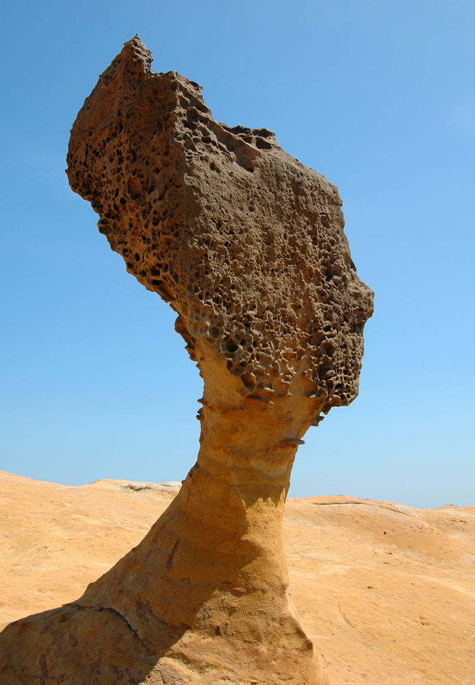
Wanli District (), known in Basay as Masu, is a rural district on the rocky seacoast in northeastern New Taipei City in northern Taiwan. Wanli is a popular tourist destination and the site of the Cape Yehliu Miocene Formation which features distinctive hoodoo outcrops. The "Queen's Head" outcrop is a Taiwanese icon and serves as an informal trademark for the township. Kataw in the adjacent Jinshan District features the Wanli Taiwanese hot springs area, which is connected with the Jinshan Hot Springs (金山溫泉).
History
The village of Masu (瑪鋉) was inhabited by Taiwanese aborigines before the era of European colonization. The area first came under the control of the Spanish, who were then ousted by the Dutch. The area began to develop when Hoklo people came to set up fishing operations.
The Ming dynasty loyalist Koxinga landed his troops at Wanli in 1661 to expel the Dutch from their northern strongholds while their principal fortress in Tainan was under siege.
In 1683, following the Qing dynasty conquest of Taiwan, the area was incorporated into Zhuluo County. In 1875, it was a member of Kimpauli (金包里堡), Kelung Sub-Subprefecture (基隆支廳).
In 1891, during Qing dynasty rule, the village was destroyed by military force as punishment for engaging in raids against Chinese camphor men and soldiers near Tokoham (modern-day Daxi).
When the Japanese took control of the island in 1895, Wanli (called Banri by the Japanese) became part of Kīrun Subprefecture, Taihoku Ken. In 1901, a reorganisation split Taihoku Ken up into smaller prefectures, with Banri becoming part of Kinpori (Kimpauli) Subprefecture, Kīrun Prefecture. In 1909, Kīrun Prefecture was amalgamated into the larger Taihoku Prefecture. This situation remained in place until the Republic of China took over administration of Taiwan at the end of World War II: Taihoku Prefecture became Taipei County, and Banri Village became Wanli Township.
Geography
Wanli is bordered to the northwest by Jinshan District, New Taipei, to the northeast by the Pacific Ocean, to the east by the Anle and Qidu Districts of Keelung. To the south is a short border with Xizhi District of New Taipei City, and to the southwest is Taipei City's Shilin District. The topography of the area is marked by the rocky Pacific coastline and the forested, mountainous interior.
Administration
Since 25 December 2010, Wanli has been administered as a district of New Taipei City. Prior to this date, Wanli was a township under Taipei County. Wanli is further subdivided into ten villages: Wanli (), Beiji (), Guihou (), Yehliu (), Dapeng (), Huangtan (), Shuangxing (), Xidi (), Kanjiao (), and Zhongfu (). Prior to the 2010 reorganization, Wanli elected its own mayor, but now as a district of New Taipei City the District Chief is appointed by the mayor of New Taipei City.
Economy
The crabbing industry is important, and in 2012 the government established the Wanli Crab brand name to boost sales.
Infrastructure
- Kuosheng Nuclear Power Plant
Tourist attractions
- Yehliu
- Yehliu Ocean World
- Feicui Bay (翡翠灣)
- Wanli UFO village, a large collection of prefabricated Futuro and Venturo homes
Notable natives
- Huang Yee-ling, singer
- Lai Ching-te, President of the Republic of China
References
References
- (3 February 2017). "Garbage Collection and Clearance Schedule in New Taipei City".
- "歷史沿革 (Historical development)". Wanli District Government.
- "里長通訊錄 (Village Leader Contact List)". Wanli District Government.
- link. (5 November 2018)
- "Wanli Crabs Make a Splash". Taiwan Panorama.
This article was imported from Wikipedia and is available under the Creative Commons Attribution-ShareAlike 4.0 License. Content has been adapted to SurfDoc format. Original contributors can be found on the article history page.
Ask Mako anything about Wanli District, New Taipei — get instant answers, deeper analysis, and related topics.
Research with MakoFree with your Surf account
Create a free account to save articles, ask Mako questions, and organize your research.
Sign up freeThis content may have been generated or modified by AI. CloudSurf Software LLC is not responsible for the accuracy, completeness, or reliability of AI-generated content. Always verify important information from primary sources.
Report