From Surf Wiki (app.surf) — the open knowledge base
Van Buren County, Arkansas
County in Arkansas, United States

County in Arkansas, United States
| Field | Value |
|---|---|
| county | Van Buren County |
| state | Arkansas |
| ex image | {{Photomontage |
| photo1a | Van Buren County Courthouse in Clinton, Arkansas.jpgVan Buren County Courthouse in downtown Clinton |
| photo2a | Gravesville Cut-Off Road near Bee Branch, Arkansas.jpg |
| photo2b | Middle Fork of the Little Red River Bridge.JPGMiddle Fork of the Little Red River Bridge |
| photo3a | Fairfield Bay, Arkansas 006.jpgLake at sunset |
| spacing | 1 |
| position | center |
| color_border | white |
| color | white |
| size | 266 |
| foot_montage | Clockwise from top: Van Buren County Courthouse in downtown Clinton, Middle Fork of the Little Red River Bridge, Greers Ferry Lake at Fairfield Bay, a hill near Bee Branch }} |
| founded year | 1833 |
| founded date | November 11 |
| seat wl | Clinton |
| largest city wl | Clinton |
| area_total_sq_mi | 724 |
| area_land_sq_mi | 708 |
| area_water_sq_mi | 16 |
| area percentage | 2.2% |
| population_as_of | 2020 |
| population_total | 15796 |
| pop_est_as_of | 2024 |
| population_est | 16152 |
| density_sq_mi | auto |
| district | 2nd |
| time zone | Central |
| named for | Martin Van Buren |
| web | http://www.vanburencountyark.com/ |
Van Buren County is a county located in the U.S. state of Arkansas. As of the 2020 census, the population was 15,796. The county seat is Clinton. The county was formed on November 11, 1833, and named for Martin Van Buren, President of the United States, who was Vice President at the time of the county's formation. Van Buren County was a dry county until November 3, 2020, as the county residents voted to make it a wet county. Van Buren County, not be confused with the city of Van Buren, which is located approximately 100 miles to the west in Crawford County just north of Fort Smith.
Geography
According to the U.S. Census Bureau, the county has a total area of 724 sqmi, of which 708 sqmi is land and 16 sqmi (2.2%) is water.
Major highways
- [[File:US 65.svg|20px]] U.S. Highway 65
- [[File:Arkansas 9.svg|20px]] Arkansas Highway 9
- [[File:Arkansas 16.svg|20px]] Arkansas Highway 16
- [[File:Arkansas 27.svg|20px]] Arkansas Highway 27
- [[File:Arkansas 92.svg|20px]] Arkansas Highway 92
- [[File:Arkansas 95.svg|20px]] Arkansas Highway 95
- [[File:Arkansas 110.svg|25px]] Arkansas Highway 110
- [[File:Arkansas 124.svg|25px]] Arkansas Highway 124
- [[File:Arkansas 254.svg|25px]] Arkansas Highway 254
- [[File:Arkansas 285.svg|25px]] Arkansas Highway 285
- [[File:Arkansas 330.svg|25px]] Arkansas Highway 330
- [[File:Arkansas 336.svg|25px]] Arkansas Highway 336
- [[File:Arkansas 337.svg|25px]] Arkansas Highway 337
- [[File:Arkansas 356.svg|25px]] Arkansas Highway 356
Transit
- Jefferson Lines
Adjacent counties
- Searcy County (north)
- Stone County (northeast)
- Cleburne County (east)
- Faulkner County (southeast)
- Conway County (southwest)
- Pope County (west)
National protected area
- Ozark National Forest (part)
Demographics
| align-fn = center 1790–1960 1900–1990 1990–2000 2010
2020 census
As of the 2020 census, the county had a population of 15,796. The median age was 50.2 years. 19.1% of residents were under the age of 18 and 27.2% of residents were 65 years of age or older. For every 100 females there were 98.0 males, and for every 100 females age 18 and over there were 96.5 males age 18 and over.
The racial makeup of the county was 91.7% White, 0.5% Black or African American, 0.8% American Indian and Alaska Native, 0.4% Asian,
There were 7,012 households in the county, of which 23.1% had children under the age of 18 living in them. Of all households, 49.2% were married-couple households, 19.9% were households with a male householder and no spouse or partner present, and 26.1% were households with a female householder and no spouse or partner present. About 32.3% of all households were made up of individuals and 18.1% had someone living alone who was 65 years of age or older.
There were 9,668 housing units, of which 27.5% were vacant. Among occupied housing units, 79.8% were owner-occupied and 20.2% were renter-occupied. The homeowner vacancy rate was 2.9% and the rental vacancy rate was 10.6%.
2000 census
As of the 2000 census, there were 16,192 people, 6,825 households, and 4,804 families residing in the county. The population density was 23 /mi2. There were 9,164 housing units at an average density of 13 /mi2. The racial makeup of the county was 96.79% White, 0.31% Black or African American, 0.75% Native American, 0.25% Asian, 0.04% Pacific Islander, 0.37% from other races, and 1.48% from two or more races. 1.33% of the population were Hispanic or Latino of any race, but the percentage could increased 3 or 4 times by seasonal migrant laborers in the county's shiitake mushroom harvest and hospitality jobs provided by the Fairfield Bay resort hotel.
There were 6,825 households, out of which 25.20% had children under the age of 18 living with them, 59.10% were married couples living together, 7.70% had a female householder with no husband present, and 29.60% were non-families. 26.40% of all households were made up of individuals, and 14.40% had someone living alone who was 65 years of age or older. The average household size was 2.33 and the average family size was 2.79.
In the county, the population was spread out, with 21.50% under the age of 18, 6.60% from 18 to 24, 23.00% from 25 to 44, 25.50% from 45 to 64, and 23.30% who were 65 years of age or older. The median age was 44 years. For every 100 females there were 96.70 males. For every 100 females age 18 and over, there were 93.00 males.
The median income for a household in the county was $27,004, and the median income for a family was $32,284. Males had a median income of $25,821 versus $18,862 for females. The per capita income for the county was $16,603. About 11.60% of families and 15.40% of the population were below the poverty line, including 21.90% of those under age 18 and 10.60% of those age 65 or over.
Government
The county government is a constitutional body granted specific powers by the Constitution of Arkansas and the Arkansas Code. The quorum court is the legislative branch of the county government and controls all spending and revenue collection. Representatives are called justices of the peace and are elected from county districts every even-numbered year. The number of districts in a county vary from nine to fifteen, and district boundaries are drawn by the county election commission. The Van Buren County Quorum Court has nine members. Presiding over quorum court meetings is the county judge, who serves as the chief operating officer of the county. The county judge is elected at-large and does not vote in quorum court business, although capable of vetoing quorum court decisions.
| Position | Officeholder | Party |
|---|---|---|
| County Judge | Dale James | Republican |
| County Clerk | Pam Bradford | Republican |
| Circuit Clerk | Debbie Gray | Republican |
| Sheriff | Eric Koonce | Republican |
| Treasurer | Mistie Wilson | Republican |
| Collector | Laura Shannon | Republican |
| Assessor | Emma R. Smiley | Republican |
| Coroner | Joe Tsosie | Republican |
The composition of the Quorum Court following the 2024 elections is 7 Republicans and 2 Independents. Justices of the Peace (members) of the Quorum Court following the elections are:
- District 1: David Holcomb (R)
- District 2: Nickie Brown (Independent)
- District 3: Sarah Brown (R)
- District 4: Mary Philips (R)
- District 5: Michael Bradford (R)
- District 6: Bailee Fowler Roberson (R)
- District 7: Becky Page (R)
- District 8: Virgil Lemings (R)
- District 9: Ester Bass (I)
Additionally, the townships of Van Buren County are entitled to elect their own respective constables, as set forth by the Constitution of Arkansas. Constables are largely of historical significance as they were used to keep the peace in rural areas when travel was more difficult. The township constables as of the 2024 elections are:
- Archey Valley: Steven R. Bannick (R)
- Bradley: William Fosse (R)
- Culpepper: Scott Bramlett (R)
- East Griggs: William Fosko (R)
- Holly Mountain: Rance Dean (R)
- Red River: Devon Laubenthal (I)
- Union: Allen Dale Roberson (R)
- Washington: Thomas Bryan Turcol (Libertarian)
Politics
Over the past few election cycles Van Buren County, like all of the traditionally secessionist and Democratic Upland South, has trended heavily towards the GOP. The last Democrat to carry this county was Bill Clinton in 1996.
Communities
Cities
- Clinton (county seat)
- Fairfield Bay (partly in Cleburne County)
Towns
- Damascus (partly in Faulkner County)
- Shirley
Census-designated place
- Bee Branch
- Dennard
Other unincorporated communities
- Alread
- Archey Valley
- Austin
- Botkinburg
- Chimes
- Choctaw
- Choctaw Pines
- Claude
- Copeland
- Crabtree
- Culpepper
- Dabney
- Eglantine
- Elba
- Fairbanks
- Formosa
- Gravesville
- Gravel Hill
- Green Tree
- Half Moon
- Morganton
- Old Botkinburg
- Palisades
- Pee Dee
- Plant
- Pleasant Grove
- Rabbit Ridge
- Rex
- Rocky Hill
- Rumley
- Rupert
- Scotland
- Southside
- Stumptoe
- Sulphur Springs
- Walnut Grove
- Whipple
- Woodlum
- Zion Hill
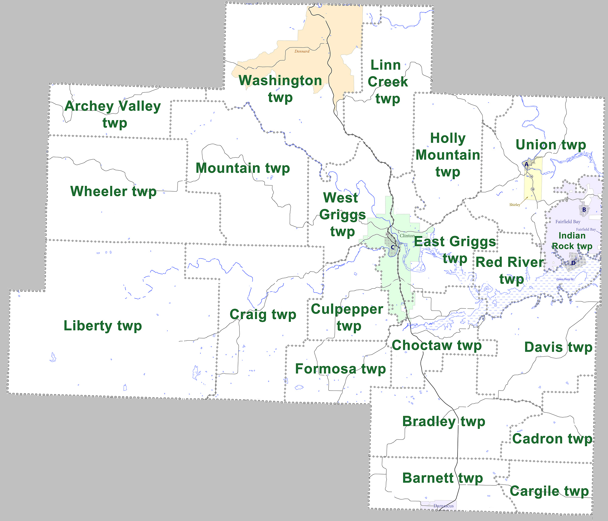
Townships
|access-date = July 26, 2011 |archive-url = https://web.archive.org/web/20121019123648/http://www2.census.gov/geo/pvs/bas/bas11/st05_ar/cou/c05141_van_buren/BAS11C20514100000_000.pdf |archive-date = October 19, 2012
| Township | FIPS code | ANSI code | |||||||||||||
|---|---|---|---|---|---|---|---|---|---|---|---|---|---|---|---|
| (GNIS ID) | Population | ||||||||||||||
| center(s) | Pop. | ||||||||||||||
| ([2010](2010-united-states-census)) | Pop. | ||||||||||||||
| density | |||||||||||||||
| (/mi2) | Pop. | ||||||||||||||
| density | |||||||||||||||
| (/km2) | Total area | ||||||||||||||
| (mi2) | Total area | ||||||||||||||
| (km2) | Land area | ||||||||||||||
| (mi2) | Land area | ||||||||||||||
| (km2) | Water area | ||||||||||||||
| (mi2) | Water area | ||||||||||||||
| (km2) | Geographic coordinates | ||||||||||||||
| Archey Valley | 144 | 6.40 | 2.47 | 22.532 sqmi | 22.492 sqmi | 0.040 sqmi | |||||||||
| Barnett | Damascus | 786 | 32.49 | 12.54 | 24.204 sqmi | 24.192 sqmi | 0.012 sqmi | ||||||||
| Bradley | 1,237 | 32.83 | 12.68 | 37.744 sqmi | 37.674 sqmi | 0.070 sqmi | |||||||||
| Cadron | 160 | 8.92 | 3.44 | 17.952 sqmi | 17.942 sqmi | 0.010 sqmi | |||||||||
| Cargile | 395 | 26.72 | 10.32 | 14.783 sqmi | 14.783 sqmi | 0 sqmi | |||||||||
| Choctaw | Clinton (small part) | 1,226 | 58.20 | 22.47 | 23.244 sqmi | 21.066 sqmi | 2.178 sqmi | ||||||||
| Craig | 739 | 15.19 | 5.87 | 48.926 sqmi | 48.655 sqmi | 0.271 sqmi | |||||||||
| Culpepper | 362 | 17.65 | 6.82 | 20.653 sqmi | 20.506 sqmi | 0.147 sqmi | |||||||||
| Davis | 892 | 24.70 | 9.54 | 36.497 sqmi | 36.113 sqmi | 0.384 sqmi | |||||||||
| East Griggs | Clinton | 1,544 | 66.04 | 25.50 | 25.579 sqmi | 23.381 sqmi | 2.198 sqmi | ||||||||
| Formosa | 675 | 33.13 | 12.79 | 20.576 sqmi | 20.377 sqmi | 0.199 sqmi | |||||||||
| Holly Mountain (fka Holley{{cite web | url=https://www.ancestry.com/interactive/7667/4211310_00364?backurl=https%3a%2f%2fsearch.ancestry.com%2fsearch%2fdb.aspx%3fdbid%3d7667%26path%3d&ssrc=&backlabel=ReturnBrowsing#?imageId=4211310_00364 | title=1860 U.S. Census for Van Buren County, Arkansas | publisher=Ancestry.com}}) | 523 | 18.21 | 9.91 | 28.764 sqmi | 28.721 sqmi | 0.043 sqmi | ||||||
| Indian Rock | Fairfield Bay | 2,227 | 160.85 | 62.10 | 13.914 sqmi | 13.845 sqmi | 0.069 sqmi | ||||||||
| Liberty | 240 | 2.47 | 0.95 | 97.551 sqmi | 97.076 sqmi | 0.475 sqmi | |||||||||
| Linn Creek | 655 | 19.35 | 7.47 | 33.982 sqmi | 33.847 sqmi | 0.135 sqmi | |||||||||
| Mountain | 390 | 8.30 | 3.20 | 47.047 sqmi | 46.979 sqmi | 0.068 sqmi | |||||||||
| Red River | 447 | 40.90 | 15.80 | 19.664 sqmi | 10.928 sqmi | 8.736 sqmi | |||||||||
| Union | Shirley | 1,497 | 33.68 | 13.01 | 45.153 sqmi | 44.448 sqmi | 0.705 sqmi | ||||||||
| Washington | Dennard | 850 | 13.82 | 5.34 | 61.634 sqmi | 61.484 sqmi | 0.150 sqmi | ||||||||
| West Griggs | Clinton | 1,970 | 67.78 | 26.17 | 29.271 sqmi | 29.069 sqmi | 0.202 sqmi | ||||||||
| Wheeler | 336 | 6.16 | 2.38 | 54.614 sqmi | 54.566 sqmi | 0.048 sqmi | |||||||||
| *Source: U.S. Census Bureau* |
Education
School districts include:
- Clinton School District
- Quitman School District
- Searcy County School District
- Shirley School District
- South Side-Bee Branch School District
- West Side School District
References
References
- "Census - Geography Profile: Van Buren County, Arkansas". [[United States Census Bureau]].
- "Find a County". National Association of Counties.
- (August 22, 2012). "2010 Census Gazetteer Files". United States Census Bureau.
- "Annual Estimates of the Resident Population for Counties: April 1, 2020 to July 1, 2023". United States Census Bureau.
- "U.S. Decennial Census". United States Census Bureau.
- "Historical Census Browser". University of Virginia Library.
- (March 27, 1995). "Population of Counties by Decennial Census: 1900 to 1990". United States Census Bureau.
- (April 2, 2001). "Census 2000 PHC-T-4. Ranking Tables for Counties: 1990 and 2000". United States Census Bureau.
- "State & County QuickFacts". United States Census Bureau.
- (2021). "2020 Decennial Census Demographic Profile (DP1)".
- (2021). "2020 Decennial Census Redistricting Data (Public Law 94-171)".
- (2023). "2020 Decennial Census Demographic and Housing Characteristics (DHC)".
- "U.S. Census website". [[United States Census Bureau]].
- "Van Buren County". Association of Arkansas Counties.
- Teske, Steven. (March 24, 2014). "Quorum Courts". [[Butler Center for Arkansas Studies]] at the [[Central Arkansas Library System]].
- Goss, Kay C.. (August 28, 2015). "Office of County Judge". Butler Center for Arkansas Studies at the Central Arkansas Library System.
- "Van Buren {{!}} Association of Arkansas Counties".
- "Election Night Reporting".
- "2022 General ElectionGeneral Election County, District OfficialsCounty, District Official".
- "Van Buren County, Arkansas, elections, 2024".
- "Election Night Reporting".
- "What is a Constable?".
- "Van Buren County, Arkansas, elections, 2024".
- "Election Night Reporting".
- "Dave Leip's Atlas of U.S. Presidential Elections".
- "Arkansas: 2010 Census Block Maps - County Subdivision". [[United States Census Bureau]].
- "County Subdivisions: Arkansas". United States Census Bureau.
- Geography Division. (December 17, 2020). "2020 CENSUS - SCHOOL DISTRICT REFERENCE MAP: Van Buren County, AR". [[U.S. Census Bureau]].
This article was imported from Wikipedia and is available under the Creative Commons Attribution-ShareAlike 4.0 License. Content has been adapted to SurfDoc format. Original contributors can be found on the article history page.
Ask Mako anything about Van Buren County, Arkansas — get instant answers, deeper analysis, and related topics.
Research with MakoFree with your Surf account
Create a free account to save articles, ask Mako questions, and organize your research.
Sign up freeThis content may have been generated or modified by AI. CloudSurf Software LLC is not responsible for the accuracy, completeness, or reliability of AI-generated content. Always verify important information from primary sources.
Report