From Surf Wiki (app.surf) — the open knowledge base
Uqturpan County
| Field | Value |
|---|---|
| name | Uqturpan County |
| native_name | |
| other_name | |
| settlement_type | County |
| image_map | Location_of_Uqturpan_within_Xinjiang_(China).png |
| map_caption | Location of Uqturpan County (red) within Aksu Prefecture (yellow) and Xinjiang |
| pushpin_map | Xinjiang#China |
| pushpin_relief | yes |
| pushpin_label | Uqturpan |
| pushpin_map_caption | Location of the seat in Xinjiang |
| parts | 3 towns, 6 townships |
| parts_type | Township-level divisions |
| subdivision_type | Country |
| subdivision_name | China |
| subdivision_type1 | Autonomous region |
| subdivision_name1 | Xinjiang |
| subdivision_type2 | Prefecture |
| subdivision_name2 | Aksu |
| seat_type | County seat |
| seat | Uqturpan Town (Wushi) |
| area_total_km2 | 9,051.54 |
| population_footnotes | |
| population_total | 205,571 |
| population_as_of | 2020 |
| population_density_km2 | auto |
| population_density_urban_km2 | auto |
| demographics_type2 | Ethnic groups |
| demographics2_title1 | Major ethnic groups |
| demographics2_info1 | Uyghur |
| coordinates | |
| elevation_footnotes | |
| elevation_m | 1200–2000 |
| elevation_ft | 3937–6561 |
| postal_code_type | Postal code |
| postal_code | 843400 |
| timezone | China Standard |
| utc_offset | +8 |
| website |
|ibox-order=ug, zh Uqturpan County or Uchturpan County (transliterated from ; ), also Wushi County (), is a county in the Xinjiang Uyghur Autonomous Region under the administration of Aksu Prefecture and shares an approximately 150 km long border with Kyrgyzstan's Issyk-Kul Region. The county is bordered to the northeast by Onsu County (Wensu), to the southeast by Aksu city, to the west by Akqi County in Kizilsu Kyrgyz Autonomous Prefecture and to the south by Kalpin County (Keping). It has an area of 9,012 km2 and a population of 180,000.
Name
Uqturpan is also spelled Uchturpan and Uch-Turfan.
History
Tang
During the Battle of Aksu (717), the Umayyad Caliphate and their Turgesh and Tibetan Empire allies hope to seize Uqturpan (then known as Dai-dʑiᴇk-dʑiᴇŋ) from Tang-Karluks-Exiled Western Turkic Khaganate allies but were repelled.
Qing
Ush Turfan was the site of a battle between Barhanuddin and Abdulla during the Revolt of the Altishahr Khojas. Six years after the Revolt of the Altishahr Khojas, ten years after the Qing's rescue of the Khoja Brothers from Dzungars, an anti-Qing uprising of the local Turkic (later "Uyghur") people took place in Uqturpan. Legend says that a local rebel leader was married to Iparhan, known as the "Fragrant Concubine" a descendant of Apaq Khoja. During the turmoil, many fled, and the thousands who remained were killed by Sino-Manchu forces. Later, the area was repopulated by migrants from what is now Southern Xinjiang.
The Ush rebellion in 1765 by Uyghurs against the Manchus occurred after Uyghur women were gang raped by the servants and son of Manchu official Su-cheng. It was said that Ush Muslims had long wanted to sleep on [Sucheng and son's] hides and eat their flesh. because of the rape of Uyghur Muslim women for months by the Manchu official Sucheng and his son. The Manchu Emperor ordered that the Uyghur rebel town be massacred, the Qing forces enslaved all the Uyghur children and women and slaughtered the Uyghur men. Manchu soldiers and Manchu officials regularly having sex with or raping Uyghur women caused massive hatred and anger by Uyghur Muslims to Manchu rule.
21st century
.jpg)
In 2012, Aqyar Township (Aheya) was made a town.

In a 2012 article from Radio Free Asia, it was reported that according to family sources and local authorities, Islam Urayim, then 32, a native of Uqturpan County who had been deported to China on December 19, 2009, despite seeking asylum in Cambodia, had been sentenced to life in prison. It was unclear when Urayim was sentenced or on what charges he was convicted.
On April 3, 2015, Imam Township (Yimamu) was made a town.
On October 27, 2019, at 1:29 PM, a 5.0-magnitude earthquake hit Uqturpan County. No casualties were reported.
According to a 2020 Radio Free Asia report, it was estimated by local officials that 20,000 Uyghurs were detained in the three re-education camps in the county.
Geography
The highest point in Uqturpan County is Zhatekelie Feng (扎特克列峰) at 5135 m above sea level.
59.9% of the territory of Uqturpan County is mountainous, 27.6% is Gobi-like desert areas and 12.5% is valley flatland.
Administrative divisions
Uqturpan County administered 3 towns, 5 townships and 1 ethnic townships:
| Name | Simplified Chinese | Hanyu Pinyin | Uyghur (UEY) | Uyghur Latin (ULY) | Administrative division code | Notes | |
|---|---|---|---|---|---|---|---|
| **Towns** | |||||||
| Uqturpan Town | |||||||
| (Wushi Town) | 乌什镇 | zh | ئۇچتۇرپان بازىرى | ug | 652927100 | ||
| Aqyar Town (Aheya, Akyar; | 阿合雅镇 | zh | ئاقيار بازىرى | ug | 652927101 | ||
| Imam Town | 依麻木镇 | zh | ئىمام بازىرى | ug | 652927102 | formerly Imam Township (依麻木乡) | |
| **Townships** | |||||||
| Aqtoqay Township | 阿克托海乡 | zh | ئاقتوقاي يېزىسى | ug | 652927200 | ||
| Yakowruk Township{{cite web | date=2014-08-11 | url=https://www.rfa.org/english/news/uyghur/murder-08112014195601.html | archive-url=https://web.archive.org/web/20200912210051/https://www.rfa.org/english/news/uyghur/murder-08112014195601.html | archive-date=12 September 2020 | title=Farmer's Murder Raises New Concerns Among Uyghurs in Xinjiang | author=Shohret Hoshur, Joshua Lipes | |
| Achatagh Township | 阿恰塔格乡 | zh | ئاچاتاغ يېزىسى | ug | 652927202 | ||
| 32FA882640A53774E0440003BA962ED3 | Yengiawat (Approved – N)}}, United States National Geospatial-Intelligence Agency | 英阿瓦提乡 | zh | يېڭىئاۋات يېزىسى | ug | 652927205 | |
| Otbeshi Township | 奥特贝希乡 | zh | ئوتبېشى يېزىسى | ug | 652927207 | ||
| **Ethnic township** | |||||||
| Yamansu Kyrgyz Ethnic Township | 亚曼苏柯尔克孜族乡 | zh | يامانسۇ قىرغىز يېزىسى | ug | 652927206 | (Kyrgyz) | |
| جامانسۇۇ قىرعىز ايىلى | |||||||
| Жаман-Суу Кыргыз айылы |
Climate
| Jan record high C = 14.8 | Jan record low C = -26.6 | Feb record high C = 14.5 | Feb record low C = -27.3 | Mar record high C = 27.1 | Mar record low C = -15.1 | Apr record high C = 31.5 | Apr record low C = -3.4 | May record high C = 32.7 | May record low C = 1.3 | Jun record high C = 35.7 | Jun record low C = 4.7 | Jul record high C = 36.9 | Jul record low C = 8.1 | Aug record high C = 35.4 | Aug record low C = 6.0 | Sep record high C = 34.2 | Sep record low C = -0.2 | Oct record high C = 28.2 | Oct record low C = -4.5 | Nov record high C = 20.1 | Nov record low C = -12.3 | Dec record high C = 16.9 | Dec record low C = -23.4 All-time Oct extremeAll-time January high
Demographics
|2000|177410 |2010|197990 |}}
As of 2015, 216,579 of the 235,336 residents of the county were Uyghur, 11,462 were Han Chinese, 5,613 were Kyrgyz and 1,682 were from other ethnic groups.
As of 1999, 90.01% of the population of Uqturpan (Wushi) County was Uyghur and 6.73% of the population was Han Chinese.
Economy
Uqturpan County's economy is primarily based on agriculture and animal husbandry, producing wheat, rice, corn, cotton, sesame ({{linktext|胡麻}}), rapeseed, and pelts. Industries include cooking oil processing, tractor repair, and construction among others.
, there was about 86,800 acres (572,793 mu) of cultivated land in Uqturpan.
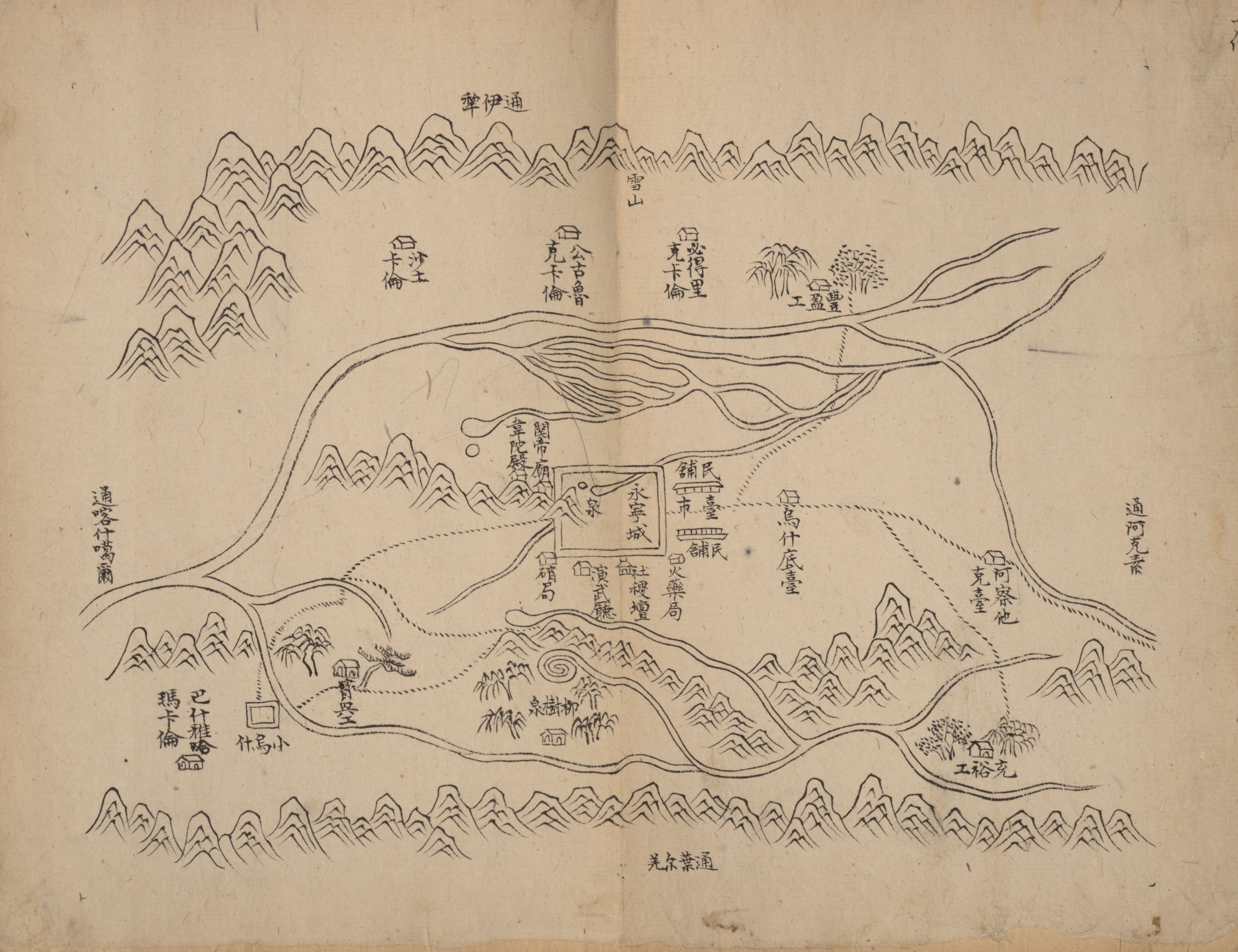
Historical maps
Historical English-language maps including Uqturpan: File:STANFORD(1917) p61 PLATE19. SINKIANG (14597194848).jpg|Map including Uqturpan (labeled as Uch Turfan) (1917) File:A-k`o-su NK-44 (1950) - panoramio.jpg|Map including Uqturpan (labeled as WU-SHIH (UCH TURFAN)) and surrounding region from the International Map of the World (AMS, 1950) File:NK-44-7 Wu-Shih China 1973.jpg|Map including Uqturpan (labeled as WU-SHIH (UCH TURFAN)) (DMA, 1973) File:Txu-pclmaps-oclc-22834566 f-6c.jpg|Map including Uqturpan (labeled as Wushi) (DMA, 1981) File:Operational Navigation Chart F-6, 6th edition.jpg|From the Operational Navigation Chart; map including Uqturpan (labeled as Wu-shih (Wushi)) (DMA, 1985)
Notes
References
References
- [http://www.citypopulation.de/en/china/xinjiang/admin/ Xinjiang: Prefectures, Cities, Districts and Counties]
- link. (10 November 2011). zh-hans. 其中维吾尔族占90.4%,
- (27 October 2019). "No casualties reported in Xinjiang earthquake".
- Alan Taylor. (8 May 2017). "Scenes From Xinjiang".
- {{GEOnet2. DB99C42FE7923C34E040D6A415F71A66. Uqturpan (Approved – N), [[National Geospatial-Intelligence Agency. United States National Geospatial-Intelligence Agency]]
- Rahman, Anwar. (2005). "Sinicization Beyond the Great Wall: China's Xinjiang Uighur Autonomous Region". Troubador Publishing Ltd.
- (4 July 2013). "Xinjiang cadres try to quell unrest ahead of July 5 anniversary".
- [[Shohret Hoshur]], Joshua Lipes. (8 September 2020). "Young Uyghur Brothers Handed Five-Year Prison Terms For 'Viewing Illegal Videos'".
- link. (24 January 2018). zh-hans. 北以天山山脉与吉尔吉斯斯坦共和国接壤。{...}境内国境边界线长155千米。
- (1902). "TURKESTAN".
- [[s:zh:資治通鑑/卷211. Section 221 (Section 27 of the Chapter ''Records of Tang'')]] of ''[[Zizhi Tongjian]]''
- Hamid Wahed Alikuzai. (October 2013). "A Concise History of Afghanistan in 25 Volumes". Trafford Publishing.
- (1878). "The Life of Yakoob Beg: Athalik Ghazi, and Bradaulet ̱of Kashgar; With Map and Appendix".
- Laura J. Newby, "'Us and Them' in Eighteenth and Nineteenth Century Xinjiang," in Ildikó Bellér-Hann, et al., eds., ''Situating the Uyghurs between China and Central Asia'' (2007), p. 26.
- (1998). "Beyond the Pass: Economy, Ethnicity, and Empire in Qing Central Asia, 1759–1864". Stanford University Press.
- (2007). "Eurasian Crossroads: A History of Xinjiang". Columbia University Press.
- (2007). "Eurasian Crossroads: A History of Xinjiang". Columbia University Press.
- (1998). "Beyond the Pass: Economy, Ethnicity, and Empire in Qing Central Asia, 1759–1864". Stanford University Press.
- "北京保利国际拍卖有限公司".
- [[Shohret Hoshur]], Parameswaran Ponnudurai. (16 January 2012). "Life in Prison for Asylum Seekers".
- (2015-05-26). "新疆维吾尔自治区人民政府关于同意乌什县依麻木乡撤乡设镇的批复(新政函〔2015〕86号)".
- [[Shohret Hoshur]], Joshua Lipes. (2 November 2020). "Six Camp Detainees From a Street in Xinjiang's Uchturpan Have Died or Are Seriously Ill".
- link. [[National Bureau of Statistics of the People's Republic of China]]. (2019). zh-hans. 统计用区划代码 名称 652927100000 乌什镇 652927101000 阿合雅镇 652927102000 依麻木镇 652927200000 阿克托海乡 652927201000 亚科瑞克乡 652927202000 阿恰塔格乡 652927205000 英阿瓦提乡 652927206000 亚曼苏柯尔克孜族乡 652927207000 奥特贝希乡
- link. (8 February 2018). zh-hans. 乌什县辖3个镇、6个乡:乌什镇、阿克托海乡、亚科瑞克乡、阿恰塔格乡、阿合雅镇、依麻木镇、英阿瓦提乡、亚曼苏乡、奥特贝希乡,共108个行政村527个村民小组、11个社区。县境内有:兵团一师四团。县人民政府驻乌什镇。
- link. XZQH.org. (27 May 2015). zh-hans. 2000年第五次人口普查,乌什县常住总人口177410人,{...}2003年,乌什县总面积9064.76平方千米,{...}2010年第六次人口普查,乌什县常住总人口197990人,其中:乌什镇27836人,阿克托海乡22870人,亚科瑞克乡17023人,阿恰塔格乡17661人,阿合雅乡34588人,依麻木乡22669人,英阿瓦提乡17614人,亚曼苏柯尔克孜族乡8554人,奥特贝希乡23283人,兵团四团5892人。 2012年,自治区政府(新政函[2012]363号)批复同意撤销阿合雅乡,设立阿合雅镇。调整后,全县辖2个镇、7个乡(其中1个民族乡):乌什镇、阿合雅镇、阿克托海依乡、亚科瑞克乡、阿恰塔格乡、依麻木乡、英阿瓦提乡、亚曼苏柯尔克孜族乡、奥特贝希乡。 2015年4月3日,自治区政府(新政函[2015]86号)批复同意撤销依麻木乡,设立依麻木镇。调整后,全县辖3个镇、6个乡(其中1个民族乡)。
- [[Shohret Hoshur]]. (18 March 2020). "Missing Uyghur Brothers Confirmed Detained in Xinjiang Internment Camp".
- (2003). Xie Yuzhong 解玉忠. [[:zh:新疆人民出版社. 新疆人民出版社]]
- (July 2008). [[:zh:国家图书馆出版社. 国家图书馆出版社]]. zh-hans. '''依麻木''' yī má mù Imam 乡名。新疆乌什县依麻木乡,在县城东北20公里。
- link. (5 June 2019). ug. ئاقتوقاي يېزىسى
- link. (14 April 2014). ug. ئۇچتۇرپان ناھىيەسى ياكۆۋرۈك يېزىسى
- link. (7 February 2020). ug. ئۇچتۇرپان ناھىيەسىنىڭ ئاچاتاغ يېزىسى
- {{GEOnet2. 32FA882640A53774E0440003BA962ED3. Yengiawat (Approved – N), [[National Geospatial-Intelligence Agency. United States National Geospatial-Intelligence Agency]]
- link. (6 January 2016). ug. ئۇچتۇرپان ناھىيەسى ئوتبېشى يېزىسى
- link. [[China Meteorological Administration]]
- "Sina Visitor System". weatherman_信欣 on [[Weibo]].
- "Sina Visitor System". weatherman_信欣 on [[Weibo]].
- link. Statistic Bureau of Xinjiang Uygur Autonomous Region. (15 March 2017). ""
- (2004). "Governing China's Multiethnic Frontiers". [[University of Washington Press]].
- (September 2009). 上海辞书出版社. [[Shanghai Lexicographical Publishing House]].
- Herold J. Wiens. (November 1966). "Cultivation Development and Expansion in China's Colonial Realm in Central Asia". [[The Journal of Asian Studies]].
This article was imported from Wikipedia and is available under the Creative Commons Attribution-ShareAlike 4.0 License. Content has been adapted to SurfDoc format. Original contributors can be found on the article history page.
Ask Mako anything about Uqturpan County — get instant answers, deeper analysis, and related topics.
Research with MakoFree with your Surf account
Create a free account to save articles, ask Mako questions, and organize your research.
Sign up freeThis content may have been generated or modified by AI. CloudSurf Software LLC is not responsible for the accuracy, completeness, or reliability of AI-generated content. Always verify important information from primary sources.
Report