From Surf Wiki (app.surf) — the open knowledge base
Umerkot District
| Field | Value |
|---|---|
| official_name | Umerkot District |
| native_name | |
| other_name | Amarkot District |
| settlement_type | District of Sindh |
| image_skyline | {{Photomontage |
| size | 250 |
| photo1a | Umarkot Fort view4.JPG |
| photo2a | Birth place monument of emperor Akbar.JPG |
| image_caption | Top: Umarkot Fort |
| Bottom: Birth place of Akbar | |
| image_map | Pakistan - Sindh - Umerkot.svg |
| map_caption | Map of Sindh with Umerkot District highlighted |
| coordinates | |
| subdivision_type | Country |
| subdivision_name | Pakistan |
| subdivision_type1 | Province |
| subdivision_name1 | Sindh |
| subdivision_type2 | Division |
| subdivision_name2 | Mirpur Khas |
| established_title | Established |
| established_date | |
| established_title1 | Abolished |
| established_date1 | |
| established_title2 | Restored |
| established_date2 | |
| seat_type | Headquarters |
| seat | Umerkot |
| parts_type | Administrative Subdivisions |
| parts_style | coll, para |
| parts | 04 |
| p1 | **Kunri Taluka** |
| **Pithoro Taluka** | |
| **Samaro Taluka** | |
| **Umerkot Taluka** | |
| government_type | District Administration |
| leader_title | Deputy Commissioner |
| leader_name | Naveed Ur Rehman Larak |
| leader_title1 | Constituensy |
| leader_name1 | NA-213 Umerkot |
| unit_pref | Metric |
| area_total_km2 | 5,608 |
| elevation_max_m | 90 |
| elevation_min_m | 3 |
| elevation_m | 21 |
| population_total | 1159831 |
| population_footnotes | |
| population_as_of | [2023](2023-pakistani-census) |
| population_density_km2 | 206.8 |
| population_urban | 258859 (22.32%) |
| population_rural | 900,972 |
| demographics1_title1 | Main language(s) |
| demographics_type2 | Literacy |
| demographics2_footnotes | |
| demographics2_title1 | Literacy rate |
| demographics2_info1 | {{ |
| timezone1 | PKT |
| utc_offset1 | +05:00 |
| timezone1_DST | DST *is not observed* |
| postal_code_type | ZIP Code |
| postal_code | 69100 |
| area_code_type | NWD (area) code |
| area_code | 238 |
| iso_code | PK-SD |
| website |
Bottom: Birth place of Akbar Pithoro Taluka Samaro Taluka Umerkot Taluka bulleted list| Total: 38.69% | Male: 51.17% | Female: 25.11%
Umerkot District (Dhatki: عمرکوٹ / عمرڪوٽ, , ), also known as Amarkot District, is a district in the southeastern part of Sindh province of Pakistan. The city of Umerkot is the capital of the district. Sindhi is the native language of approximately 95.1% of the residents according to the 2023 Pakistani census. According to latest census estimate, the population of district is 1,158,284 (1.15 million). Umerkot is the only non-Muslim majority district in Pakistan, with adherents of Hinduism representing 54.7% of the total population as per 2023 Pakistani census.
History
Main article: Sodhas of Amarkot
Akbar was born in Umerkot Fort when his father Humayun was fleeing from the Suris. After the 1843 invasion by Charles Napier, Sindh was divided into provinces, and Zamindars, also known as Wadaras, were assigned to collect taxes for the British.
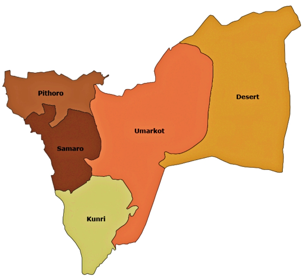
Administration
The district is administratively subdivided into the following Tehsils:
- Kunri
- Pithoro
- Samaro
- Umarkot
Demographics
|1998 |664797 |2017 |1073469 |2023 |1159831
As of the 2023 census, Umerkot district has 222,562 households and a population of 1,159,831. The district has a sex ratio of 109.73 males to 100 females and a literacy rate of 38.69%: 51.17% for males and 25.11% for females. 406,585 (35.1% of the surveyed population) are under 10 years of age. 258,859 (22.32%) live in urban areas.
Languages
At the time of the 2023 census, 95.13% of the population spoke Sindhi, 1.8% Punjabi and 1.4% Urdu as their first language.
Religion
| Religious | |||||||||||||||||
|---|---|---|---|---|---|---|---|---|---|---|---|---|---|---|---|---|---|
| group | 1941 | 2017 | 2023 | Pop. | % | Pop. | % | Pop. | % | Total Population | 119,026 | 100% | 1,073,469 | 100% | 1,158,284 | 100% | |
| Islam [[File:Star_and_Crescent.svg | 15x15px]] | 55,175 | 46.36% | 507,691 | 47.29% | 519,276 | 44.83% | ||||||||||
| Hinduism [[File:Om.svg | 16x16px]] | 54,055 | 45.41% | 559,824 | 52.15% | 633,114 | 54.66% | ||||||||||
| Tribal | 7,522 | 6.32% | |||||||||||||||
| Sikhism [[File:Khanda.svg | 19x19px]] | 1,943 | 1.63% | 36 | ~0% | ||||||||||||
| Christianity [[File:Christian_cross.svg | 21x21px]] | 280 | 0.24% | 2,326 | 0.22% | 2,702 | 0.23% | ||||||||||
| Ahmadi | 3,594 | 0.33% | 3,093 | 0.27% | |||||||||||||
| Others | 51 | 0.04% | 34 | 0.01% | 63 | 0.01% |
| Circle | Hindus | Muslims | Others |
|---|---|---|---|
| Kunri | 56.37% | 42.07% | 1.56% |
| Pithoro | 48.48% | 50.85% | 0.67% |
| Samaro | 53.98% | 45.87% | 0.15% |
| Umerkot | 55.52% | 44.3% | 0.18% |
Umerkot is the only Hindu majority district in Pakistan. Hindus form around 55% and Muslims form around 45% of Umerkot's population.
The Umarkot Shiv Mandir in Umerkot is one of the oldest and most sacred Hindu temples in the Sindh. The annual Maha Shivratri celebration of the temple is one of the biggest religious festivals in Pakistan and is attended by around 250,000 people.
List of Dehs
The following is list of Umerkot District's dehs, organised by taluka:
- Umarkot Taluka (90 dehs)
- Aahir East
- Ahori Chore
- Ashabo
- Banhyari
- Behrai Thar
- Belo Karna
- Bhodar
- Chelari
- Chore Thar
- Chundawah
- Debo
- Dhorosirin
- Dingralo
- Dinore
- Diyatbah
- Doodhar
- Dugoo
- Gamoori
- Gapno
- Gorsar
- Harh
- Hasisar
- Horingo
- Janhero Pat
- Janhero Thar
- Juneja
- Kacholi
- Kaith
- Kalri
- Kaplore
- Karna
- Khalrai Thar
- Kharoro Jagir
- Kharoro Pat
- Kharoro Thar
- Khejrari
- Khiral
- Khirohi
- Khunhar
- Kunar
- Kunjeli
- Lalabah
- Laplo
- Larh
- Lashari
- Makhyaro
- Mandhal
- Marwah
- Mehparo
- Mokhal Bah
- Muhammad Aalam Palli
- Nabisar Thar
- Narhadi
- Noonhyoon
- Okkaro
- Old Chore/Chore Purano
- Padrio
- Panjoi
- Parhyaro
- Rabario
- Rajar Thar
- Rajari Thar
- Sabhri Pat
- Sabrhi Thar
- Sabo
- Sadoori Pat
- Sadoori Thar
- Sahib Tar
- Sarangsar
- Sarreti
- Senhoi Thar
- Shakh Khejrari
- Shekhro
- Sidhore
- Sonhari
- Sonpur
- Soofi
- Soonhin
- Tal
- Tangore
- Tar Samoon
- Tebhri
- Thathrai
- Timo Mitho
- Umerkot Pat
- Umerkot Thar
- Veerasar
- Vehro Thar
- Walhate
- Walidad Palli
- Samaro Taluka (59 dehs)
- 207
- 207-A
- 325
- 326
- 327
- 327-A
- 12-Hiral
- 13-Hiral
- 13-A Hiral
- 14-Hiral
- 15-Hiral
- 16-Hiral
- 17-Hiral
- 18-Hiral
- 19-Hiral
- 20-Hiral
- 21-Hiral
- 22-Hiral
- 23-Hiral
- 24-Hiral
- 25-Hiral
- 26-Hiral
- 27-Hiral
- 28-Hiral
- 29-Hiral
- 30-Hiral
- Araro
- Araro Bhurgari
- Bhambhra
- Bhurgari
- Bikhori
- Chach
- Chachh Bhurgari
- Chan Qabol
- Dabho
- Dengan Bhurgari
- Gharo Bhiro
- Gora Band
- Hassan Baghban
- Jhaluri
- Kangani
- Khani
- Kharoro East
- Khosan Ji Wai
- Kinjhji
- Liyari
- Lolan
- Moraso
- Old Samaro
- Potho
- Ram Jago
- Sandharo
- Shah Hassan
- Shakh Samaro
- Soonthi
- Tibuhi
- Timo Kharo
- Tobhan Wari
- Waraso
- Pithoro Taluka (48 dehs)
- Akri Wadi
- Bandho
- Bareji
- Bhitaro
- Changul
- Chhachro
- Chhelyoon
- Dandhi
- Darero
- Dengan Palli
- Ghulam Nabi Shah
- Gorhadi
- Gularki
- Gurki
- Hiral-1
- Hiral-2
- Hiral-3
- Hiral-4
- Hiral-5
- Hiral-5/A
- Hiral-6
- Hiral-7
- Hiral-9
- Hiral-10
- Hiral-11
- Jago
- Jambho Kandi
- Jhirkyari
- Karu
- Khambhri
- Khuda Bux Mari
- Khun
- Korki
- Lanairo
- Langani
- Morhango
- Muhari
- Naar
- New Khipri
- Palli
- Pirore
- Pithoro
- Saaduri
- Shadi Palli
- Sinhedi
- Ubandh
- Vikhadi
- Kunri Taluka (38 dehs)
- Barani
- Bustan
- Chajro
- Char
- Dadhro
- Dambherlo
- Darelo
- Fateh Dandh
- Gharakaringa
- Goraho
- Haido
- Janjhi
- Kandiyari
- Karchelo
- Khamno
- Kharo Kun
- Khuda Bux Chandio
- Kunri
- Kuria
- Malansar
- Malook Shah
- Manjhakar
- Mayadars
- Mojan
- Moondawai
- Morjhango
- Nabisar
- Naseer Chandio
- Rahmore
- Rajari Pat
- Ranawai
- Rindki
- Sadki
- Sanwari
- Seerkhi
- Shahliwai
- Shakh Darelo
- Talhi
References
References
- "Literacy rate, enrolments, and out-of-school population by sex and rural/urban, CENSUS-2023, SINDH".
- "Pakistan Census 2023".
- "Religious Demographics of Pakistan 2023".
- [http://www.umerkot.gos.pk DISTRICT GOVERNMENT - Umerkot] {{Webarchive. link. (2012-02-24)
- "Population by administrative units 1951-1998". [[Pakistan Bureau of Statistics]].
- "7th Population and Housing Census - Detailed Results: Table 20".
- "7th Population and Housing Census - Detailed Results: Table 1".
- "7th Population and Housing Census - Detailed Results: Table 12".
- "7th Population and Housing Census - Detailed Results: Table 5".
- "7th Population and Housing Census - Detailed Results: Table 11".
- "CENSUS OF INDIA, 1941 VOLUME XII SINDH PROVINCE".
- "District Statistics (Census - 2017) - Umerkot District".
- "7th Population and Housing Census - Detailed Results: Table 9".
- "The thriving Shiva festival in Umarkot is a reminder of Sindh's Hindu heritage". Dawn.
- "List of Dehs in Sindh".
This article was imported from Wikipedia and is available under the Creative Commons Attribution-ShareAlike 4.0 License. Content has been adapted to SurfDoc format. Original contributors can be found on the article history page.
Ask Mako anything about Umerkot District — get instant answers, deeper analysis, and related topics.
Research with MakoFree with your Surf account
Create a free account to save articles, ask Mako questions, and organize your research.
Sign up freeThis content may have been generated or modified by AI. CloudSurf Software LLC is not responsible for the accuracy, completeness, or reliability of AI-generated content. Always verify important information from primary sources.
Report