From Surf Wiki (app.surf) — the open knowledge base
Typhoon Choi-wan (2009)
Pacific typhoon in 2009

Pacific typhoon in 2009
| Field | Value |
|---|---|
| name | Typhoon Choi-wan |
| image | Choi-wan 2009-09-16 0125Z.jpg |
| caption | Typhoon Choi-wan at peak intensity on September 16 |
| formed | September 11, 2009 |
| extratropical | September 20, 2009 |
| dissipated | September 21, 2009 |
Typhoon Choi-wan was a powerful typhoon that became the first Category 5-equivalent super typhoon to form during the 2009 Pacific typhoon season. Forming on September 11, 2009, about 1100 km to the east of Guam, the initial disturbance rapidly organized into a tropical depression. By September 12, the depression intensified into a tropical storm, at which time it was given the name Choi-wan. The following day, rapid intensification took place through September 14. Choi-wan attained its peak intensity on September 15, as it moved through the Northern Mariana Islands with the Japan Meteorological Agency reporting peak 10-minute sustained winds of 195 km/h. Additionally, the Joint Typhoon Warning Center reported the storm to have attained 1-minute sustained winds of 260 km/h. The typhoon remained very powerful until September 17 when the storm's outflow weakened. The typhoon underwent an eyewall replacement cycle, leading to intensity fluctuations. By September 19, Choi-wan rapidly weakened as strong wind shear caused convection to diminish. The following day, the system transitioned into an extratropical cyclone and dissipated several hours later over open waters.
Despite the intensity of Choi-wan when it passed through the Northern Mariana Islands, no casualties were reported. However, following the storm, the United States Navy deemed that the island of Alamagan was uninhabitable, with all but one of the structures completely destroyed and most of the islands' trees downed. In response to this, all residents on the island were evacuated to nearby Saipan.
Meteorological history
Early on September 11, the Joint Typhoon Warning Center (JTWC) began monitoring an area of convection roughly 1,100 km east of Guam. A broad, low-level circulation center had formed within the system and became increasingly organized, showing signs of developing convective banding. A Tropical Cyclone Formation Alert was released later that day as convection was rapidly consolidating around the low, which was embedded within the eastern end of the monsoonal trough. It was then declared as a tropical depression by the Japan Meteorological Agency (JMA) and the JTWC with the latter designating it as Tropical Depression 15W The tropical depression was tracking westward along the southern edge of the subtropical ridge situated east of the International Date Line.
During September 12, the depression continued to develop quickly with both the JMA and the JTWC reporting that the depression had intensified into a Tropical Storm later that day, with the JMA assigning the international name of Choi-wan and the international designation of 0915. During September 13, Choi-wan gradually developed whilst moving west with the JMA reporting that Choi-wan had become a severe tropical storm late that day, before reporting along with the JTWC early the next day that Choi-wan had intensified further and had become a weak Typhoon with multiple spiral bands that had wrapped into the fully consolidated center to form a banding eye. During September 14, Choi-wan intensified further whilst moving along the southwestern edge of a deep level subtropical ridge of the northeast, intensifying into a Category 4-equivalent typhoon on the Saffir–Simpson hurricane scale with 1-minute winds of 220 km/h.
Early on September 15, the JTWC reported that Typhoon Choi-wan had intensified further and had become a Category 4-equivalent Super Typhoon whilst passing over the island of Alamagan. Later that day the JMA reported that Typhoon Choi-wan had reached its 10-minute peak wind speeds of 195 km/h and a pressure of 915 hPa (mbar). Typhoon Choi-wan then intensified further and reached its peak 1-minute wind speeds of 260 km/h which made it the first Category 5-equivalent tropical cyclone on the Saffir–Simpson hurricane scale anywhere in the world in 2009.
With the help of excellent poleward outflow and high ocean heat content, Typhoon Choi-wan remained at its peak intensity until early on September 17 when deep convection started to erode in the northwestern quadrant as the tropical upper tropospheric trough (TUTT) cell to the northwest was no longer providing good outflow. Choi-wan was then downgraded to a typhoon by the JTWC as it started to undergo an eyewall replacement cycle, with the JTWC reporting a secondary peak intensity of 150 km/h, during the next day. During September 19, Choi-wan rapidly weakened, as it moved into an unfavorable environment with higher amounts of vertical wind shear, causing the storm's deep convection to erode. As a result of this and dry latitude air wrapping into the low level circulation center, the JTWC decided to downgrade Choi-wan to an extratropical system and released their final advisory, early the next day before the JMA followed suit later that day. The JMA then reported that the extratropical low had dissipated completely, early on September 21.
Preparations
Mariana Islands
Early on September 12, the National Weather Service Weather Forecast Office in Guam, using data from the JTWC, placed Tinian and Saipan under a Typhoon Watch whilst declaring a Tropical Storm Watch also declared for Guam and Rota. By September 15, the islands of Agrihan, Tinian and Saipan before being upgraded to tropical storm warnings and a typhoon watch. Additionally, the watches in place for Guam and Rota were discontinued. These warnings were kept in force until late on September 14, when the warnings for Tinian were canceled and the typhoon watch for Saipan was canceled, while the typhoon watch was upgraded to a Typhoon Warning as Choi-wan rapidly intensified. The Tropical Storm Warning in place for Saipan was canceled during September 15 as Choi-wan intensified into a high-end Category 4 equivalent super typhoon. All watches and warnings were discontinued during the afternoon of September 16 once Choi-wan was no longer a threat to the Mariana Islands.
By September 15, shelters were opened throughout Tinian and Saipan at local schools, most schools and all governmental buildings were closed and residents rushed to board up their homes. The American Red Cross had also mobilized on the islands by this time. Some private schools were open during the morning but let out early to allow students to return to their families before the typhoon's arrival. On Saipan, 179 residents sought refuge in shelters by the afternoon of September 15, by which time heavy rain had begun falling. Only one flight was delayed by the typhoon across all the islands. The youth basketball league in the Northern Mariana Islands canceled their games for the time Choi-wan passed through the islands. At the height of the storm, a total of 270 residents sought refuge in shelters on Saipan.
Japan
Early on September 16 the JMA started to issue Typhoon force wind warnings, for the Naha, Okinawa; however these were discontinued later that day. The JMA then placed the Yokohama, Moji and Naha under a Typhoon Warning early the next day. These warnings were kept in place until early on September 19, when the JMA added the Kushiro and Otaru to the warnings. However, the warnings were dropped for all areas except Yokohama and Kushiro as the typhoon turned away from Japan. These warnings stayed in effect until late the next day when they were cancelled as Choi-wan began to dissipate.
Impact and aftermath
On September 15, the eye of Choi-wan passed within 10 km of Alamagan and brought winds of up to 230 km/h to the island. The most recent storm of Choi-wan's intensity to strike the islands was Chaba in 2004. That storm caused severe damage and widespread flooding. Unlike Chaba, relatively little rainfall fell due to Choi-wan, and no flooding was reported. The main effects from the typhoon in Saipan were downed trees which littered streets across the islands. Power lines were downed and sewer pipes were broken; however, crews began repairing damage once Choi-wan passed. In Garapan, the major shelter on the island sustained minor damage and repair work on it would take roughly a week.
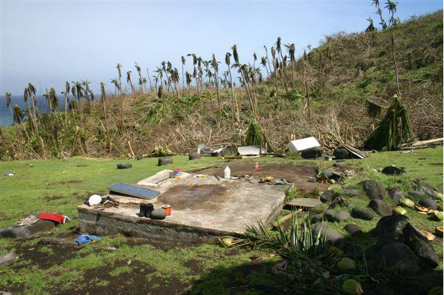
On Alamagan, residents attempted to contact officials on other islands on September 17. Despite the extreme intensity of the storm, all sixteen residents on the island, including the 4-day old infant were safe. During their attempted contact, the connection was poor and hard to understand. The following day, the United States Navy sent a ship and helicopter to the island to assess the situation. The Navy stated that the entire island of Alamagan was a total loss, with all but one of the structures, a facility for laboratory and research, completely destroyed and most of the islands' trees downed.
Once on the island, they determined that all residents needed to be evacuated "...whether they like or not". The first to be evacuated from the island were the infant and six people in the family; the infant was taken to a hospital on Saipan as a precaution. On nearby Agrihan, it was determined that the residents on the island also needed to be evacuated. Prior to their evacuations, they were given relief supplies, mainly food and water, to survive for five days. Roughly 260 gallons of fresh water, 50 lbs of rice and other health or comfort supplies were delivered by Helicopter Sea Combat Squadron 25 to both islands. On September 21, the Salvation Army announced that residents displaced by the storm would be received donated items, such as clothing, toys, pillows and baby formula.
References
References
- (2009-09-11). "Significant Tropical Weather Advisory for the Western and Southern Pacific Oceans 2009-09-11 14z".
- (2009-09-11). "Tropical Cyclone Formation Alert 2009-09-11 22z". [[Joint Typhoon Warning Center]].
- (2009-09-12). "JMA WWJP25 Advisory 2009-09-12 00z".
- (2009-09-12). "JTWC Prognostic Reasoning 2009-09-12 03z".
- (2009-09-12). "JTWC: Tropical Cyclone Advisory 2009-09-12 21z".
- (2009-09-12). "JMA Tropical Cyclone Advisory 2009-09-12 18z". [[Japan Meteorological Agency]].
- (2009-09-13). "JMA Tropical Cyclone Advisory 2009-09-13 18z". [[Japan Meteorological Agency]].
- (2009-09-14). "JMA Tropical Cyclone Advisory 2009-09-14 00z". [[Japan Meteorological Agency]].
- (2009-09-14). "JTWC Prognostic Reasoning 2009-09-14 03z".
- (2009-09-10). "Super Typhoon 15W Choi-wan Best Track Data". [[United States Naval Research Laboratory]].
- (2009-09-15). "JTWC: Tropical Cyclone Advisory 2009-09-15 09z".
- Patrick Chan. (2009-09-15). "Typhoon Choi-wan Intermediate Advisory Number 13A". [[National Weather Service.
- (2009-11-13). "RSMC Tropical Cyclone Best Track:Typhoon Choiwan (0914)". [[Japan Meteorological Agency]].
- Aaron Sheldrick. (2009-09-16). "Typhoon Choi-Wan Strengthens to Category 5 in Pacific (Update3)". [[Bloomberg Television]].
- (2009-09-15). "JTWC:Tropical Cyclone Advisory 2009-09-15 09z".
- (2009-09-17). "JTWC Prognostic Reasoning 2009-09-17 03z".
- (2009-09-18). "JTWC Tropical Cyclone Advisory 2009-09-18 09z".
- (2009-09-20). "JTWC:Tropical Cyclone Advisory 2009-09-20 03z".
- (2009-09-20). "JMA Advisory 2009-09-20 12z". [[Japan Meteorological Agency]].
- Dan Mundell. (September 12, 2009). "Tropical Depression 15W Advisory Number One". [[National Weather Service.
- Carol Baqui and Paul Stanko. (September 12, 2009). "Tropical Depression 15W Advisory Number Three". [[National Weather Service.
- Patrick Chan, Dan Mundell and Roger Edson. (September 13, 2009). "Tropical Storm Choi-wan (15W) Advisory Number Five". [[National Weather Service.
- Derek Williams. (September 15, 2009). "Typhoon Choi-wan (15) Advisory Number Eleven". [[National Weather Service.
- Clint Simpson and Michael Middlebrooke. (September 15, 2009). "Typhoon Choi-wan (15W) Advisory Number Twelve". [[National Weather Service.
- Derek Williams and Dan Mundell. (September 16, 2009). "Super Typhoon Choi-wan (15W) Advisory Number 15". [[National Weather Service.
- Clint Simpson. (September 16, 2009). "Super Typhoon Choi-wan (15W) Advisory Number Seventeen". [[National Weather Service.
- Haidee V. Eugenio. (September 14, 2009). "Red Cross mobilizes volunteers, provides typhoon shelter kits". Saipan Tribune.
- Ferdie de la Torre. (September 15, 2009). "179 people taken to shelters". Saipan Tribune.
- Moneth Deposa. (September 16, 2009). "Only Cape Air flight was delayed". Saipan Tribune.
- Nazario Rodriguez Jr. (September 15, 2009). "BANMI cancels games in Rotary, IT&E caging". Saipan Tribune.
- (September 16, 2009). "JMA WWJP25 Advisory 2009-09-16 06z".
- (September 15, 2009). "JMA WWJP25 Advisory 2009-09-16 18z".
- (September 17, 2009). "JMA WWJP25 Advisory 2009-09-17 00z".
- (September 17, 2009). "JMA WWJP25 Advisory 2009-09-17 06z".
- (September 19, 2009). "JMA WWJP25 Advisory 2009-09-19 06z".
- (September 19, 2009). "JMA WWJP25 Advisory 2009-09-19 18z".
- (September 21, 2009). "JMA WWJP25 Advisory 2009-09-21 00z".
- Haidee V. Eugenio. (2009-09-16). "Red Cross says no damaged homes; community cleans up debris". Saipan Tribune.
- Moneth Deposa. (2009-09-18). "Man'Amko Center in Garapan closed for a week". Saipan Tribune.
- Ferdie de la Torre. (2009-09-17). "Alamagan, Agrihan residents all safe". Saipan Tribune.
- Staff Writer. (2009-09-18). "Sablan: Navy helping CNMI in typhoon recovery". Pacific Daily News.
- Ferdie de la Torre. (2009-09-19). "All residents of Alamagan, Agrihan facing evacuation". Saipan Tribune.
- Staff Writer. (2009-09-21). "Salvation Army responds to typhoon victims". Saipan Tribune.
This article was imported from Wikipedia and is available under the Creative Commons Attribution-ShareAlike 4.0 License. Content has been adapted to SurfDoc format. Original contributors can be found on the article history page.
Ask Mako anything about Typhoon Choi-wan (2009) — get instant answers, deeper analysis, and related topics.
Research with MakoFree with your Surf account
Create a free account to save articles, ask Mako questions, and organize your research.
Sign up freeThis content may have been generated or modified by AI. CloudSurf Software LLC is not responsible for the accuracy, completeness, or reliability of AI-generated content. Always verify important information from primary sources.
Report