From Surf Wiki (app.surf) — the open knowledge base
Tucumcari, New Mexico
City in the United States
.jpg)
City in the United States
| Field | Value |
|---|---|
| name | Tucumcari, New Mexico |
| settlement_type | City |
| image_skyline | Quay County Courthouse.jpg |
| image_caption | Quay County Courthouse in 2008 |
| image_seal | Tucumcari logo.jpg |
| image_map | Quay_County_New_Mexico_Incorporated_and_Unincorporated_areas_Tucumcari_Highlighted.svg |
| mapsize | 250px |
| map_caption | Location of Tucumcari in New Mexico |
| pushpin_map | New Mexico#USA |
| pushpin_label | Tucumcari |
| pushpin_map_caption | Location in New Mexico##Location in the United States |
| pushpin_relief | yes |
| subdivision_type | Country |
| subdivision_type1 | State |
| subdivision_type2 | County |
| subdivision_name | United States |
| subdivision_name1 | New Mexico |
| subdivision_name2 | Quay |
| leader_title | Mayor |
| leader_name | Marcy Willis |
| established_title | Founded |
| established_date | 1901 |
| unit_pref | Imperial |
| area_footnotes | |
| area_total_sq_mi | 9.51 |
| area_total_km2 | 24.63 |
| area_land_sq_mi | 9.51 |
| area_land_km2 | 24.62 |
| area_water_sq_mi | 0.00 |
| area_water_km2 | 0.00 |
| population_as_of | [2020](2020-united-states-census) |
| population_footnotes | |
| population_total | 5278 |
| population_density_km2 | 214.34 |
| population_density_sq_mi | 555.17 |
| timezone | MST |
| utc_offset | −7 |
| timezone_DST | MDT |
| utc_offset_DST | −6 |
| coordinates | |
| elevation_footnotes | |
| elevation_ft | 4032 |
| postal_code_type | ZIP code |
| postal_code | 88401 |
| area_code | 575 |
| blank_name | FIPS code |
| blank_info | 35-79910 |
| blank1_name | GNIS feature ID |
| blank1_info | 2412105 |
| website |
Tucumcari (; ) is a city in and the county seat of Quay County, New Mexico, United States. The population was 5,278 at the 2020 census. Tucumcari was founded in 1901, two years before Quay County was established.
History
In 1901, the Chicago, Rock Island and Pacific Railroad built a construction camp in the western portion of modern-day Quay County. Originally called Ragtown, the camp became known as "Six Shooter Siding", due to numerous gunfights. Its first formal name, Douglas, was used only for a short time. After it grew into a permanent settlement, it was renamed Tucumcari in 1908. The name was taken from Tucumcari Mountain, which is situated near the community. The origin of the mountain's name is uncertain; it may have been derived from the Comanche word tʉkamʉkarʉ, which means "ambush". A 1777 burial record mentions a Comanche woman and her child captured in a battle at Cuchuncari, which is believed to be an early version of the name Tucumcari. A folk etymology for the town name claims that a Comanche saw a brakeman carrying a lantern and exclaimed "tukaʔ manoori!, carry the light!", which the brakeman heard as "tukama carry".
In December 1951, a water storage tank collapsed in the city. Four were killed and numerous buildings were destroyed.
In 2014, a series of suspicious fires destroyed abandoned buildings, including the Tucumcari Motel, Payless Motel, and a house in the 500 block of North Fourth Street. A former Tucumcari Police Department officer and several others were charged with arson.
The town formerly hosted an air show each year. The show held on October 4, 2006, was canceled after one hour when a single-engine plane crashed, resulting in the pilot's death.
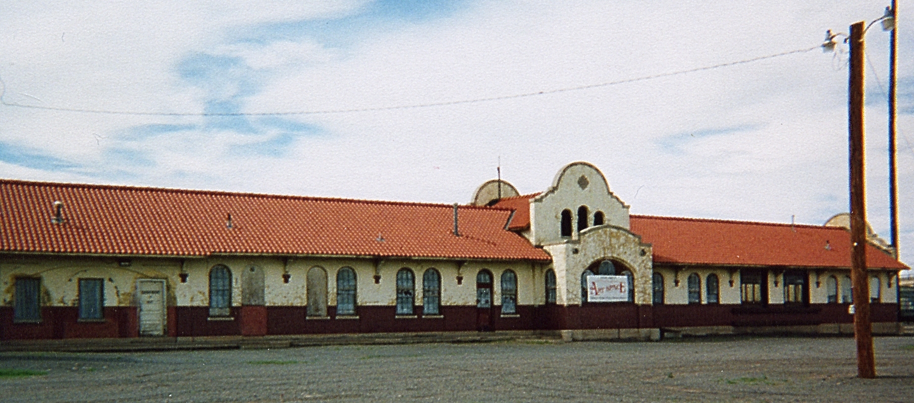
Former railroad transit point
Tucumcari until the mid-twentieth century was a junction for transcontinental train service. The Rock Island Railroad ran pool train operations with the Southern Pacific (originally the El Paso and Northeastern Railway), with transfers at the station (for the Tucumcari-Los Angeles leg of the trip). The Choctaw Rocket (Memphis-Little Rock-Tucumcari-El Paso-Los Angeles) made the switch there (for the coach cars). The Golden State (Chicago-Kansas City-Topeka-Tucumcari-El Paso-Los Angeles) ran continuously through the town.
Cattle ranches
- Bell Ranch - created from a land grant in 1824 and now one of the largest ranches in the United States
- T4 Cattle Company - founded in 1902 and continues to be a family run enterprise, one of the country's largest ranches
Geography
According to the United States Census Bureau, the city has a total area of 19.6 km2, of which 19.5 km2 is land and 0.13% is water.
Climate
Tucumcari has a cool semi-arid climate (Köppen BSk), characterized by cool winters and hot summers. Rainfall is relatively low except during the summer months, when thunderstorms associated with the North American monsoon can bring locally heavy downpours. Snowfall is generally light, with an average of 14.9 in. Due to the frequency of low humidity, wide daily temperature variations are normal.
The record high temperature at Tucumcari was 111 F on June 11, 2022, and the record low temperature -22 F on January 13, 1963. The hottest monthly mean maximum has been 100.5 F in July 2011 and the coldest mean minimum 12.4 F in January 1963, although the coldest month by mean maximum was January 1949, with a mean high of 38.6 F.
The wettest calendar year has been 1941, with 34.94 in and the driest, 1934, with 6.13 in. The most rainfall in one month was 11.19 in in July 1950. The most rainfall in 24 hours was 4.41 in on June 21, 1971. The most snowfall in one year was 51.2 in, from July 1911 to June 1912. The most snowfall in one month was 30.0 in, in February 1912.
|Jan record high F = 80 |Feb record high F = 87 |Mar record high F = 92 |Apr record high F = 97 |May record high F = 103 |Jun record high F = 111 |Jul record high F = 110 |Aug record high F = 108 |Sep record high F = 105 |Oct record high F = 97 |Nov record high F = 90 |Dec record high F = 82 |year record high F =
|Jan avg record high F = 72.1 |Feb avg record high F = 76.9 |Mar avg record high F = 84.4 |Apr avg record high F = 89.3 |May avg record high F = 95.8 |Jun avg record high F = 103.5 |Jul avg record high F = 103.8 |Aug avg record high F = 101.4 |Sep avg record high F = 98.0 |Oct avg record high F = 90.8 |Nov avg record high F = 81.1 |Dec avg record high F = 73.2 |year avg record high F = 105.7
|Jan avg record low F = 9.2 |Feb avg record low F = 12.0 |Mar avg record low F = 18.2 |Apr avg record low F = 27.6 |May avg record low F = 37.0 |Jun avg record low F = 50.4 |Jul avg record low F = 58.5 |Aug avg record low F = 56.8 |Sep avg record low F = 43.5 |Oct avg record low F = 28.1 |Nov avg record low F = 17.3 |Dec avg record low F = 8.7 |year avg record low F = 4.2
|Jan record low F = −22 |Feb record low F = −16 |Mar record low F = −3 |Apr record low F = 14 |May record low F = 25 |Jun record low F = 37 |Jul record low F = 52 |Aug record low F = 49 |Sep record low F = 30 |Oct record low F = 12 |Nov record low F = −2 |Dec record low F = −12 |year record low F =
|Jan snow depth inch = 3.7 |Feb snow depth inch = 1.9 |Mar snow depth inch = 1.8 |Apr snow depth inch = 0.8 |May snow depth inch = 0.0 |Jun snow depth inch = 0.0 |Jul snow depth inch = 0.0 |Aug snow depth inch = 0.0 |Sep snow depth inch = 0.0 |Oct snow depth inch = 0.4 |Nov snow depth inch = 1.9 |Dec snow depth inch = 3.6 |year snow depth inch = 5.8
|access-date = November 1, 2022 |access-date = November 1, 2022
Demographics

As of the census of 2000, there were 5,989 people, 2,489 households, and 1,607 families residing in the city. The population density was 793.8 PD/sqmi. There were 3,065 housing units at an average density of 406.2 /sqmi. The racial makeup of the city was 75.87% White, 1.29% African American, 1.39% Native American, 1.20% Asian, 0.22% Pacific Islander, 17.10% from other races, and 2.94% from two or more races. Hispanic or Latino of any race were 51.41% of the population.
There were 2,489 households, out of which 29.8% had children under the age of 18 living with them, 45.4% were married couples living together, 15.3% had a female householder with no husband present, and 35.4% were non-families. 31.7% of all households were made up of individuals, and 14.7% had someone living alone who was 65 years of age or older. The average household size was 2.35 and the average family size was 2.93.
In the city, the population was spread out, with 26.0% under the age of 18, 7.5% from 18 to 24, 24.2% from 25 to 44, 24.8% from 45 to 64, and 17.5% who were 65 years of age or older. The median age was 39 years. For every 100 females, there were 90.9 males. For every 100 females age 18 and over, there were 86.8 males.
The median income for a household in the city was $22,560, and the median income for a family was $27,468. Males had a median income of $25,342 versus $18,568 for females. The per capita income for the city was $14,786. About 19.1% of families and 24.8% of the population were below the poverty line, including 29.5% of those under age 18 and 16.7% of those age 65 or over.
Arts and culture
The buildings formerly at Metropolitan Park (locally known as "Five Mile Park" because it is located about five miles (8 km) outside of town) were designed by Trent Thomas, adapted from his design of La Fonda Hotel in Santa Fe. The park once featured New Mexico's largest outdoor swimming pool. Owing to deterioration, Metropolitan Park was named to the New Mexico Heritage Preservation Alliance's list of Most Endangered for 2003. In 2010, the park's main building caught fire and burnt to the ground. The city of Tucumcari razed the site weeks after the fire. Art City sculpture park can be found a few miles north of the city.
Tucumcari Tonite, Route 66, and tourism

For many years, Tucumcari has been a popular stop for cross-country travelers on Interstate 40 (formerly U.S. Route 66 in the area). It is the largest city on the highway between Amarillo, Texas and Albuquerque, New Mexico. Billboards reading "TUCUMCARI TONITE!" placed along I-40 for many miles to the east and west of the town invite motorists to stay the night in one of Tucumcari's "2000" (later changed to "1200") motel rooms. The "TUCUMCARI TONITE!" campaign was abandoned in favor of a campaign which declared Tucumcari, "Gateway to the West". However, on June 24, 2008, Tucumcari's Lodgers Tax Advisory Board, the group responsible for the billboards, voted to return to the previous slogan.
Old U.S. Route 66 runs through the heart of Tucumcari via Route 66 Boulevard, which was previously known as Tucumcari Boulevard from 1970 to 2003 and as Gaynell Avenue before that time. Numerous businesses, including gasoline service stations, restaurants, and motels, were constructed to accommodate tourists as they traveled through on the Mother Road. A large number of the vintage motels and restaurants built in the 1930s, 1940s, and 1950s are still in business despite intense competition from newer chain motels and restaurants in the vicinity of Interstate 40, which passes through the city's outskirts on the south.
Tucumcari is the home of over 50 murals. Most were painted by artists Doug and Sharon Quarles and serve as a tourist attraction.
Downtown
Most of Tucumcari's oldest buildings lie along or near Main Street in the Historic Downtown area. These include:
- Rock Island-Southern Pacific Train Station (built 1926, restored 2011)
- Odeon Theatre (built 1937, still operating)
- Crescent Creamery (vacant)
- Masonic Temple (still operating)
- Princess Theater (under renovation)
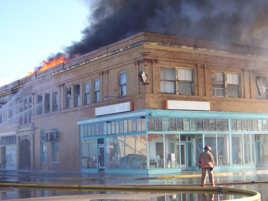
Also located in the downtown area are the concrete arches that once surrounded the Hotel Vorenburg, which was demolished in the 1970s after being damaged by fire. The Federal Building, commonly known as Sands-Dorsey Drug, was damaged by two fires before finally being demolished in 2015. The location is now a park.
Education
It is a part of the Tucumcari Public Schools school district. Schools in Tucumcari include:
- Tucumcari Early Head Start and Head Start (non-public daycare and preschool)
- Tucumcari Elementary School (public Pre-K through fifth grade)
- Tucumcari Middle School (public sixth grade through eighth grade)
- Tucumcari High School (public ninth grade through twelfth grade)
Tertiary schools:
- Mesalands Community College (community two-year institution of higher learning)
Notable people
- Paul Brinegar, an American character actor, was born in Tucumcari.
- Abel Cullum, former King of the Cage Flyweight Champion
- Stan David, a Tucumcari High School graduate, was a star safety for the Texas Tech Red Raiders and played 16 NFL games for the Buffalo Bills in 1984.
- Tom "Black Jack" Ketchum and his associates robbed a post office and store in Liberty, NM, in 1896.
- Runner Rex Maddaford, a Tucumcari Public Schools faculty member, competed for the New Zealand team in the 1968 Summer Olympics.
- Bob Scobey, a musician, was born in Tucumcari in 1916.
In popular culture
- Many of the scenes in the television show Rawhide (1959–1966) starring Clint Eastwood were shot in the Tucumcari area. Paul Brinegar, who played Wishbone, was from Tucumcari.
- In the movie, For a Few Dollars More by Sergio Leone featuring Clint Eastwood and Lee Van Cleef, the town of Tucumcari, is mentioned repeatedly. Filming actually occurred in Tabernas, Almería, Spain.
- In the novel series by David Stone featuring Micah Dalton, the lead character was raised in Tucumcari.
- Scenes for the film Hell or High Water were filmed in Tucumcari on June 1, 2015.
- Tucumcari was featured in the television series Better Call Saul.
References
References
- "Commissioners and Their Districts".
- "ArcGIS REST Services Directory". United States Census Bureau.
- {{GNIS. 2412105
- "Find a County". National Association of Counties.
- "QuickFacts Tucumcari city, New Mexico".
- "About Tucumcari".
- "Quay County {{!}} NM Counties".
- "Tucumcari". New Mexico Office of the State Historian.
- "Photo Guide:T". Southwest Collection Library.
- Lila Wistrand-Robinson & James Armagost. ''Comanche Dictionary and Grammar'', 2nd edition (2012, Summer Institute of Linguistics).
- "Cuchuncari", however, is from Old Comanche ''kuhtsunkarɨ'' 'buffalo sitting'.
- (January 2000). ""Comanche Land and Ever Has Been ": A Native Geography of the Nineteenth-Century Comancheria". Texas State Historical Association.
- (1952). "The Tucumcari Tank Failure: New Mexico Society of Professional Engineers [with Discussion]". Journal (American Water Works Association).
- "Payless Inn, abandoned house destroyed by fire".
- "Former Tucumcari police officer target of state police investigation".
- "Fires destroy 2 abandoned Tucumcari motels".
- link. (2007-09-28)
- "Census of Population and Housing". Census.gov.
- "Census Population API". United States Census Bureau.
- "U.S. Census website". [[United States Census Bureau]].
- link. (2007-02-12)
- "Officials to relocate playground equipment | playground, relocate, officials - News - Quay County Sun".
- "Visit Art City: Tucumcari, New Mexico's Sculpture Park and Glamping Resort".
- (June 25, 2008). "'Tucumcari Tonite' Returns to Billboards". Albuquerque Journal.
- (February 6, 2019). "New Mexico couple's murals helping bring tourists to their town". [[KRQE]].
- (2012-05-08). "Sands-Dorsey building collapses under fire". Quay County Sun.
- (2015-07-28). "City acquires the Sands Dorsey building for demolition". Quay County Sun.
- "2020 CENSUS - SCHOOL DISTRICT REFERENCE MAP: Quay County, NM". [[U.S. Census Bureau]].
- Wilson, Earl. (March 2022). "Small Towns Have Produced Many Big Stars". The Milwaukee Sentinel.
- "SI.com - SI 50th - New Mexico - The 50 Greatest New Mexico Sports Figures - Wednesday July 09, 2003 04:11 PM". CNN.
- "Quay County Sun".
- "Yahoo!".
- (October 2024). "Domain Inquiry". jcgi.pathfinder.com.
- [https://books.google.com/books?id=mp9CEiBSL1MC&q=tucumcari Google Books: ''The Echelon Vendetta'']
- "Hollywood comes to Tucumcari".
This article was imported from Wikipedia and is available under the Creative Commons Attribution-ShareAlike 4.0 License. Content has been adapted to SurfDoc format. Original contributors can be found on the article history page.
Ask Mako anything about Tucumcari, New Mexico — get instant answers, deeper analysis, and related topics.
Research with MakoFree with your Surf account
Create a free account to save articles, ask Mako questions, and organize your research.
Sign up freeThis content may have been generated or modified by AI. CloudSurf Software LLC is not responsible for the accuracy, completeness, or reliability of AI-generated content. Always verify important information from primary sources.
Report