From Surf Wiki (app.surf) — the open knowledge base
Tehran
Capital and largest city of Iran

Capital and largest city of Iran
| Field | Value |
|---|---|
| name | Tehran |
| native_name | تهران |
| settlement_type | Capital city |
| image_skyline | {{multiple image |
| border | infobox |
| perrow | 1/2/2/2 |
| total_width | 300 |
| align | center |
| image1 | North of Tehran Skyline view.jpg |
| caption1 | Tehran skyline and the Alborz |
| image2 | آتشفشان_دماوند.jpg |
| caption2 | Milad Tower and Mount Damavand |
| image3 | Azadi_Tower_(29358497718).jpg |
| caption3 | Azadi Tower |
| image4 | Palais du Golestan, Téhéran (5).jpg |
| caption4 | Golestan Palace |
| image5 | 0549-سردر باغ ملی.jpg |
| caption5 | National Garden |
| image6 | Bagh-e Ferdows Tajrish.jpg |
| caption6 | Ferdows Garden |
| image7 | 2011 Ahmad-Shahi Pavilion Tehran 6214852688 by Kamyar Adl.jpg |
| caption7 | Niavaran Complex |
| image8 | TitSh1.jpg |
| caption8 | City Theater |
| image9 | Národní_muzeum_Íránu.jpg |
| caption9 | National Museum |
| image_flag | Flag of Tehran.svg |
| image_seal | لوگو شهرداری تهران.svg |
| pushpin_map | Iran#Middle East#Asia |
| pushpin_relief | yes |
| pushpin_map_caption | Location in Iran and Asia |
| mapframe-caption | Map of Tehran |
| mapframe | yes |
| coordinates | |
| subdivision_type | Country |
| subdivision_name | Iran |
| subdivision_type1 | Province |
| subdivision_type2 | County |
| subdivision_type3 | District |
| subdivision_name1 | Tehran |
| subdivision_name2 | Tehran |
| Rey | |
| Shemiranat | |
| subdivision_name3 | Central |
| leader_title | Mayor |
| leader_name | Alireza Zakani |
| leader_title2 | City Council Chairman |
| leader_name2 | Mehdi Chamran |
| area_footnotes | |
| area_urban_km2 | 750 |
| area_metro_km2 | 2235 |
| elevation_footnotes | |
| elevation_m | 1040 to 2040 |
| elevation_ft | 3412 to 6692 |
| population_total | 8,693,706 |
| population_as_of | 2016 census |
| population_footnotes | |
| pop_est_as_of | 2021 |
| population_est | 9,039,000 |
| population_metro_footnotes | (2025) |
| population_metro | 14,557,000 (province) |
| population_blank1_title | Population rank in Iran |
| population_blank1 | 1st |
| population_demonym | Tehrani (en) |
| population_density_km2 | 12,052 |
| area_code | +98 21 |
| blank_name | Climate |
| blank_info | BSk |
| timezone | IRST |
| utc_offset | +03:30 |
| website | [tehran.ir](https://en.tehran.ir/) |
the Iranian capital city
| mapframe-caption = Map of Tehran Rey Shemiranat
Tehran is the capital and largest city of Iran. It is also the capital of Tehran province and the administrative center for Tehran County and its Central District. With a population of around 9 million in the city, and 16.8 million in the metropolitan area, Tehran is the most populous city in Iran and West Asia, the second-largest metropolitan area in the Middle East after Cairo, and the 24th-most-populous metropolitan area in the world. Greater Tehran includes several municipalities, including Karaj, Eslamshahr, Shahriar, Qods, Malard, Golestan, Pakdasht, Qarchak, Nasimshahr, Parand, Pardis, Andisheh and Fardis.
In classical antiquity, part of the territory of present-day Tehran was occupied by Rhages (now Ray), a prominent Median city that was destroyed in the medieval Arab, Turkic, and Mongol invasions. Modern Ray was absorbed into the metropolitan area of Greater Tehran. Tehran was first chosen as the capital of Iran in 1786 by Agha Mohammad Khan of the Qajar dynasty, because of its proximity to Iran's territories in the Caucasus—which were contested in the Russo-Iranian Wars—and to avoid the vying factions of prior ruling Iranian dynasties; the capital of Iran had been moved several times throughout its long history, with Tehran becoming the 32nd. Under Naser al-Din Shah (1848-1896), Tehran witnessed Iran's first institute of higher learning, bank, railway line, and museum. Large-scale construction works began in the 1920s, and Tehran became a destination for mass migrations from all over Iran especially in the 20th century.
Tehran is home to many historical sites, including the World Heritage Site Golestan Palace of the Qajar dynasty and the Masoudieh, Sa'dabad, Niavaran and Marmar palace complexes of both the Qajar and Pahlavi dynasties. Landmarks include the Azadi Tower, a memorial built in 1971 to mark the 2,500th anniversary of the Persian Empire; the Milad Tower, the world's sixth-tallest self-supporting tower, completed in 2007; and the Tabiat Bridge, completed in 2014.
Most residents of Tehran are Persian, of whom roughly 99% speak the Persian language; there are numerous other ethnolinguistic groups that are Persianised and assimilated. Tehran has been described as a cultural "melting pot", hosting more Azerbaijanis than any other city in the world. Tehran is served by Imam Khomeini International Airport, alongside the domestic Mehrabad Airport, a central railway station, Tehran Metro, the Tehran Bus Rapid Transit system, trolleybuses, and a large network of highways.
Because of air pollution and earthquakes, there have been plans to relocate the capital to another area, although none have been approved. A 2016 survey of 230 cities across the globe by Mercer ranked Tehran 203rd for quality of life. According to the Global Destinations Cities Index in 2016, Tehran was among the top ten fastest growing tourism destinations. In 2016, the Tehran City Council declared 6 October "Tehran Day", celebrating the date in 1907 when the city officially became the capital of Iran.
Etymology
Various theories on the origin of the name Tehran have been put forward. Iranian linguist Ahmad Kasravi, in an article "Shemiran-Tehran", suggests that Tehran, and Kehran mean "the warm place", and "Shemiran" means "the cool place". He lists cities with the same base and suffix and studied the components of the word in ancient Iranian languages, and came to the conclusion that Tehran and Kehran meant the same thing in different Iranian language families, as the constant "t" and "k" are close to each other in such languages. He also provided evidence that cities named "Shemiran" were colder than those named "Tehran" or "Kehran". He considered other theories not consider the ancient history of Iranian languages, such as "Tirgan" theory and "Tahran" theory folk etymology.
The official City of Tehran website says that "Tehran" comes from the Persian words "Tah" meaning "end", or "bottom", and "Ran" meaning "[mountain] slope"—, the bottom of the mountain (ته کوه), referring to Tehran's position at the foot of the Alborz mountains.
In English, it is also spelt "Teheran", with both variants being used in books since at least 1800, and "Teheran" being the dominant form from after WWII until shortly before the Islamic Revolution.
History
Archaeological remains from the ancient city of Ray suggest that settlement in Tehran dates back over 6,000 years.
Classical era
Tehran is in the historical Media region of ( peo) in northwestern Iran. By the time of the Median Empire, part of present-day Tehran was a suburb of the prominent Median city of Rhages ( peo). In the Avesta's Videvdat (i, 15), Rhages is mentioned as the 12th sacred place created by Ohrmazd. In Old Persian inscriptions, Rhages appears as a province (Bistun 2, 10–18). From Rhages, Darius I sent reinforcements to his father Hystaspes, who was putting down a rebellion in Parthia (Bistun 3, 1–10). Some Middle Persian texts give Rhages as the birthplace of Zoroaster, although modern historians generally place the birth of Zoroaster in Khorasan province.
Mount Damavand, the highest peak of Iran, which is located near Tehran, is an important location in Ferdowsi's Šāhnāme, an Iranian epic poem based on the ancient legends of Iran. It appears in the epics as the homeland of the protoplast Keyumars, the birthplace of King Manuchehr, the place where King Fereydun bound the dragon fiend Zahhak (Bivarasp), and the place where Arash shot his arrow.
Medieval period
In 641, during the reign of the Sasanian Empire, Yazdgerd III issued his last appeal to the nation from Rhages, before fleeing to Khorasan. Rhages was dominated by the Parthian House of Mihran, and Siyavakhsh—the son of Mehran, the son of Bahram Chobin—who resisted the seventh-century Muslim invasion of Iran. Because of this resistance, when the Arabs captured Rhages, they ordered the town destroyed and rebuilt anew by traitor aristocrat Farrukhzad.
In the ninth century, Tehran was a well-known village, but less so than Rhages, flourishing nearby. Rhages was described in detail by tenth-century Muslim geographers. Despite the interest that Arabian Baghdad displayed in Rhages, the number of Arabs in the city remained insignificant and the population mainly consisted of Iranians of all classes.
The Oghuz Turks invaded Rhages in 1035 and again in 1042, but the city was recovered under the Seljuks and the Khwarezmians. Medieval writer Najm od Din Razi declared the population of Rhages about 500,000 before the Mongol invasion. In the 13th century, the Mongols invaded Rhages, laid the city to ruins, and massacred many of its inhabitants. Others escaped to Tehran. In July 1404, Castilian ambassador Ruy González de Clavijo visited Tehran on a journey to Samarkand, the capital of Turco-Mongol conqueror Timur, the ruler of Iran at the time. He described it in his diary as an unwalled region.
Early modern era
Italian traveler Pietro della Valle passed through Tehran overnight in 1618, and in his memoirs called the city Taheran. English traveler Thomas Herbert entered Tehran in 1627, and mentioned it as Tyroan. Herbert states that the city had about 3,000 houses.
In the early 18th century, Karim Khan of the Zand dynasty ordered a palace and a government office built in Tehran, possibly to declare the city his capital; but he later moved his government to Shiraz. Eventually, Qajar king Agha Mohammad Khan chose Tehran as the capital of Iran in 1786. Khan's choice of his capital was based on a similar concern for the control of both northern and southern Iran. He was aware of the loyalties of the inhabitants of former capitals Isfahan and Shiraz to the Safavid and Zand dynasties respectively, and was wary of the power of the local notables in these cities. Thus, he probably viewed Tehran's lack of a substantial urban structure as a blessing, because it minimized the chances of resistance to his rule by the notables and by the general public. He had to remain within close reach of Azerbaijan and Iran's integral northern and southern Caucasian territories—at that time not yet irrevocably lost per the treaties of Golestan and Turkmenchay to the neighboring Russian Empire—which would follow in the course of the 19th century.
After 50 years of Qajar rule, the city still barely had more than 80,000 inhabitants. Up until the 1870s, Tehran consisted of a walled citadel, a roofed bazaar, and the three main neighborhoods of Udlajan, Chale-Meydan, and Sangelaj, where the majority resided.
During the long reign of Naser al-Din Shah (1848-1896), Tehran witnessed Iran's first institute of higher learning, bank, railway line and museum. The Golestan Palace was significantly rebuilt and expanded in 1865 by Haji Ab ol Hasan Mimar Navai, including the Brilliant Hall, the Mirror Hall and the Edifice of the Sun. The city expanded rapidly through multiple development plans. The first development plan in 1855 emphasized traditional spatial structure. The second, under the supervision of Dar ol Fonun in 1878, included new city walls, in the form of a perfect octagon with an area of 19 square kilometers, mimicking the Renaissance cities of Europe. Tehran was 19.79 square kilometers and had expanded more than fourfold.
Late modern era
Growing awareness of civil rights resulted in the Constitutional Revolution and the first constitution of Iran in 1906. On 2 June 1907, the parliament passed a law on local governance known as the Baladie (municipal law), providing a detailed outline of issues such as the role of councils within the city, the members' qualifications, the election process, and the requirements to be entitled to vote.
Mohammad Ali Shah abolished the constitution and bombarded the parliament with the help of the Russian-controlled Cossack Brigade on 23 June 1908. That was followed by the capture of the city by the revolutionary forces of Ali-Qoli Khan (Sardar Asad II) and Mohammad Vali Khan (Sepahsalar e Tonekaboni) on 13 July 1909. As a result, the monarch was exiled and replaced by his son Ahmad, and the parliament was re-established.
During the Persian campaign of World War I, Russian forces that were occupying the northwest of Iran marched around Qazvin and approached Tehran, causing a crisis and the dissolution of parliament. Ahmad Shah Qajar and his entourage decided to leave Tehran and move the capital to another place, sparking fears of rebellion in other cities. During the Battle of Robat Karim, Iranian forces led by Heydar Latifiyan prevented the Russians from taking Tehran, despite the latter winning the battle. This also allowed government functions to be moved to Qom and then to Isfahan, while the monarchy remained in Tehran.
Pahlavi rule

After World War I, the constituent assembly elected Reza Shah of the Pahlavi dynasty as the new monarch, who immediately suspended the Baladie law of 1907, replacing the decentralized and autonomous city councils with centralist approaches to governance and planning. From the 1920s to the 1930s, under the rule of Reza Shah, the city was rebuilt. Several old buildings, including parts of the Golestan Palace, Tekye Dowlat, and Tupkhane Square, were replaced with modern buildings influenced by classical Iranian architecture, particularly the buildings of the National Bank, the police headquarters, the telegraph office, and the military academy.
Changes to the urban fabric began with the street-widening act of 1933, which served as a framework for changes in all other cities. The Grand Bazaar was divided in half and many historic buildings were demolished and replaced by wide straight avenues, and the traditional texture of the city was replaced with intersecting cruciform streets that created large roundabouts in major public spaces such as the bazaar. As an attempt to create a network for easy transportation within the city, the old citadel and city walls were demolished in 1937, replaced by wide streets cutting through the urban fabric. By 1937, the city was heavily influenced by modernist planning patterns of zoning and gridiron networks.
During World War II, Soviet and British troops entered the city. In 1943, Tehran was the site of the Tehran Conference, attended by U.S. President Franklin D. Roosevelt, Soviet premier Joseph Stalin, and British Prime Minister Winston Churchill.
The establishment of the planning organization of Iran in 1948 resulted in the first socioeconomic development plan covering the period from 1949 to 1955. These plans not only failed to slow the unbalanced growth of Tehran but, with the 1962 land reforms that Reza Shah's son and successor, Mohammad Reza Shah named the White Revolution, Tehran's chaotic growth was further accentuated.
In the 1960s and 1970s, Tehran developed rapidly under Mohammad Reza Shah. Modern buildings altered the face of Tehran, and ambitious projects were planned for the following decades. To resolve the problem of social exclusion, the first comprehensive plan was approved in 1968. The consortium of Iranian architect Abd-ol-Aziz Farmanfarmaian and the American firm of Victor Gruen Associates identified the main problems blighting the city as high-density suburbs, air and water pollution, inefficient infrastructure, unemployment, and rural-urban migration. Eventually, the whole plan was marginalized by the 1979 Revolution and the subsequent Iran–Iraq War.
Tehran's most famous landmark, the Azadi Tower, was built by the order of the Shah in 1971. It was designed by Hossein Amanat, an architect whose design won a competition, combining elements of classical Sassanian architecture with post-classical Iranian architecture. Formerly known as the Shahyad Tower, it was built to commemorate the 2,500th anniversary of the Imperial State of Iran.
Islamic Republic

Following the 1979 Islamic Revolution, Tehran underwent profound transformations in its urban landscape, political structure, and social dynamics. The revolution led to the establishment of the Islamic Republic of Iran, which brought about a shift from a pro-Western monarchy to a theocratic system based on Islamic principles. This change was reflected in various aspects of Tehran's development. Politically, the revolution resulted in the consolidation of power by forces loyal to Ayatollah Ruhollah Khomeini, the leader of the revolution. This period saw the establishment of new governance structures aligned with Islamic ideologies.
During the Iran–Iraq War from 1980 to 1988, Tehran was repeatedly targeted by airstrikes and Scud missile attacks, and the war led to substantial infrastructural damage.
The 435-meter-high Milad Tower, one of the proposed development projects of pre-revolutionary Iran, was completed in 2007 and has become a famous landmark of Tehran. Tabiat Bridge, a 270-meter pedestrian overpass that was designed by award-winning architect Leila Araghian, was completed in 2014. The city municipality started planting a large number of imported palm trees, replacing endemic plane trees. In June 2025, Tehran was attacked by Israeli airstrikes. On June 2025 an unprecedented event in the history of Iran and Tehran took place as people of Tehran committed mass evacuation.
Demographics
.png)
Population
| 1554| 1,000 | 1626| 3,000 | 1797| 15,000 | 1807| 50,000 | 1812| 60,000 | 1834| 80,000 | 1867| 147,256 | 1930| 250,000 | 1940| 540,087 | 1956| 1,560,934 | 1966| 2,719,730 | 1976| 4,530,223 | 1986| 6,058,207 | 1991| 6,497,238 | 1996| 6,758,845 | 2006| 7,711,230 | 2011| 8,244,759 | 2016| 8,737,510
Tehran had a population of 7,711,230 people, in 2,286,787 households at the time of the 2006 National Census. The 2011 census counted 8,154,051 people, in 2,624,511 households. The 2016 census recorded 8,693,706 people, in 2,911,065 households.
Language and ethnicity
With its cosmopolitan atmosphere, Tehran is home to diverse ethnic and linguistic groups from all over the country. The present-day dominant language is the Tehrani variety of the Persian language, and the majority of people identify themselves as Persians. Historically the native language of the Tehran–Ray region was not Persian, which is linguistically Southwest Iranian and originates in Fars, but an extinct Persian dialect and Northwestern Iranian language.
Iranian Azeris are the second-largest ethnic group, comprising about 10-15% of the population. Ethnic Mazanderanis are the third-largest, comprising about 5% of the population. Tehran's other ethnic communities include Kurds, Armenians, Georgians, Bakhtyaris, Talysh, Baloch, Assyrians, Arabs, Jews, and Circassians. In the 2010 census by the Sociology Department of the University of Tehran, in many districts of Tehran across various socio-economic classes in proportion to population sizes of each district and socio-economic class, 63% of the people were born in Tehran, 98% knew Persian, 75% identified themselves as ethnic Persian, and 13% had some degree of proficiency in a European language.
There was a drastic change in ethnic-social composition in the early 1980s. After the political, social, and economic consequences of the 1979 Revolution and the years that followed, many Iranian citizens, mostly Tehranis, left Iran. The majority of Iranian emigrations have left for the United States, Germany, Sweden, and Canada. With the start of the Iran–Iraq War, a second wave of inhabitants fled the city, especially during the Iraqi air offensives on Tehran. With most major powers backing Iraq at the time, economic isolation gave yet more reason for many inhabitants to leave Tehran and the country. Having left all they had and having struggled to adapt to a new country and build a life, most of them never came back when the war was over. During the war, Tehran received a great number of migrants from the west and the southwest of Iran bordering Iraq. The unstable situation and the war in neighbouring Afghanistan and Iraq prompted a rush of refugees into Iran, who arrived in millions. Tehran was a magnet for many seeking work, who helped Tehran to recover from war wounds, working for a far lower pay than local construction workers. Many of these refugees are being repatriated with the assistance of the UNHCR, but there are still sizable groups of Afghan and Iraqi refugees in Tehran who are reluctant to leave, being pessimistic about the situation in their own countries. Afghan refugees are mostly Dari-speaking Tajik and Hazara, speaking a variety of Persian, and Iraqi refugees are mainly Mesopotamian Arabic-speakers who are often of Iranian and Persian ethnic heritage.
Religion
The majority of religious Tehrani are officially Twelver Shia Muslims, which has been the main religion since the 16th-century Safavid conversion. Other religious communities include followers of the Sunni and Mystic branches of Islam, Christian denominations, Judaism, Zoroastrianism, and the Baháʼí Faith. +
In the 2016 "Tehran Survey", when residents of Tehran were asked about the importance of religion in their life, 53.5% considered it to be "very important / important", 31.1% to be "rather important", 10.5% to be "not very important" and 4.8% to be "not at all important."
There are many religious centres scattered around Tehran, from old to newly built centres, including mosques, churches, synagogues, and Zoroastrian fire temples. Tehran has a very small third-generation Indian Sikh community with a local gurdwara that was visited by the Indian Prime Minister, Manmohan Singh in 2012.
Geography
Location and subdivisions
City of Tehran is bounded in the north by southern end and the highest point of Alborz Mountain Range (Tochal Peak, 3'963m), in the east by a hilly stretch of Alborz (namely, Sorkheh Hesar National Park, part of Khojir National Park and the northeastern badlands), in the southeast by Raga Mountain and in the west and southwest by fertile meadows and many villages, fed by numerous rivers and streams, mainly Karaj and Jajrud.
The metropolis is divided into 22 municipal districts, each with its administrative center. Of the 22 municipal districts, 20 are located in Tehran County's Central District, while districts 1 and 20 are respectively located in the counties of Shemiranat and Ray.
|}
| Name | Persian Name | County | Number of | |||||
|---|---|---|---|---|---|---|---|---|
| Municipal Regions | Area | Population | Population Density | Location within Tehran | ||||
| District 1 | منطقه ۱ – Mantaqe ye Yek | Shemiranat County | 10 | km² | 487,508 | /km² | [[File:Tehran1.PNG | 200px]] |
| District 2 | منطقه ۲ – Mantaqe ye Do | Tehran County | 9 | km² | 701,303 | /km² | [[File:Tehran2.PNG | 200px]] |
| District 3 | منطقه ۳ – Mantaqe ye Se | Tehran County | 6 | km² | 330,649 | /km² | [[File:Tehran3.PNG | 200px]] |
| District 4 | منطقه ۴ – Mantaqe ye Chahār | Tehran County | 9 | km² | 919,001 | /km² | [[File:Tehran4.PNG | 200px]] |
| District 5 | منطقه ۵ – Mantaqe ye Panj | Tehran County | 7 | km² | 858,346 | /km² | [[File:Tehran5.PNG | 200px]] |
| District 6 | منطقه ۶ – Mantaqe ye Šeŝ | Tehran County | 6 | km² | 251,384 | /km² | [[File:Tehran6.PNG | 200px]] |
| District 7 | منطقه ۷ – Mantaqe ye Haft | Tehran County | 5 | km² | 312,194 | /km² | [[File:Tehran7.PNG | 200px]] |
| District 8 | منطقه ۸ – Mantaqe ye Haŝt | Tehran County | 3 | km² | 425,197 | /km² | [[File:Tehran8.PNG | 200px]] |
| District 9 | منطقه ۹ – Mantaqe ye Noh | Tehran County | 3 | km² | 174,239 | /km² | [[File:Tehran9.PNG | 200px]] |
| District 10 | منطقه ۱۰ – Mantaqe ye Dah | Tehran County | 3 | km² | 327,115 | /km² | [[File:Tehran10.PNG | 200px]] |
| District 11 | منطقه ۱۱ – Mantaqe ye Yāzdah | Tehran County | 4 | km² | 307,940 | /km² | [[File:Tehran11.PNG | 200px]] |
| District 12 | منطقه ۱۲ – Mantaqe ye Davāzdah | Tehran County | 6 | km² | 241,831 | /km² | [[File:Tehran12.PNG | 200px]] |
| District 13 | منطقه ۱۳ – Mantaqe ye Sizdah | Tehran County | 4 | km² | 248,952 | /km² | [[File:Tehran13.PNG | 200px]] |
| District 14 | منطقه ۱۴ – Mantaqe ye Ĉahārdah | Tehran County | 6 | km² | 515,795 | /km² | [[File:Tehran14.PNG | 200px]] |
| District 15 | منطقه ۱۵ – Mantaqe ye Pānzdah | Tehran County | 6 | km² | 641,279 | /km² | [[File:Tehran15.PNG | 200px]] |
| District 16 | منطقه ۱۶ – Mantaqe ye Ŝānzdah | Tehran County | 6 | km² | 268,406 | /km² | [[File:Tehran16.PNG | 200px]] |
| District 17 | منطقه ۱۷ – Mantaqe ye Hefdah | Tehran County | 3 | km² | 273,231 | /km² | [[File:Tehran17.PNG | 200px]] |
| District 18 | منطقه ۱۸ – Mantaqe ye Heĵdah | Tehran County | 5 | km² | 419,882 | /km² | [[File:Tehran18.PNG | 200px]] |
| District 19 | منطقه ۱۹ – Mantaqe ye Nuzdah | Tehran County | 3 | km² | 261,027 | /km² | [[File:Tehran19.PNG | 200px]] |
| District 20 | منطقه ۲۰ – Mantaqe ye Bist | Ray County | 5 | km² | 365,259 | /km² | [[File:Tehran20.PNG | 200px]] |
| District 21 | منطقه ۲۱ – Mantaqe ye Bist-o-Yek | Tehran County | 3 | km² | 186,821 | /km² | [[File:Tehran21.PNG | 200px]] |
| District 22 | منطقه ۲۲ – Mantaqe ye Bist-o-Do | Tehran County | 4 | km² | 176,347 | /km² | [[File:Tehran22.PNG | 200px]] |
|}
Northern Tehran is the wealthiest part of the city, with districts such as Zafaraniyeh, Jordan, Elahiyeh, Pasdaran, Kamranieh, Ajodanieh, Farmanieh, Darrous, Niavaran, Jamaran, Aghdasieh, Mahmoodieh, Velenjak, Qeytarieh, Ozgol and Ekhtiarieh. The city center houses government ministries and headquarters. Commercial centers are located further north.
Topography
Northern Tehran is at the foot of Alborz, starting at an elevation of 1800 meters, with many houses and streets on steep slopes and hills. There is a stretch of hills in the middle of the city (which historically divided Tehran and Shemiran) with its highest point at 1500 m. Southwards and westwards of those hills, Tehran is less steep. On the east, there are numerous hills, with the highest point at 1950 m. The southern end of Tehran (Rey) is at 1100 m, next to a single mountain (Raga) at 1500 m.
Climate
Tehran lies at the southern foot of the Alborz Mountains and the northern edge of the Iranian Central Plateau, giving the city a complex climate. According to the Köppen climate classification system, the bulk of metropolitan Tehran is classified as a cold semi-arid (BSk), while lower elevation suburbs and plains (near Mehrābād Airport) verge on a hot semi-arid (BSh) classification. At the same time, the elevated northern districts (such as Shemiran) approach a Mediterranean climate (Csa) type.
The city’s wide elevation range—from approximately 1,100 m above sea level in the southern plains to over 1,800 m in the northern suburbs—yields pronounced topographic micro-climates. The elevation rises up to 2000 m at the end of Velenjak in northern Tehran. Northern parts of Tehran tend to be cooler, receive slightly more precipitation (including more snow), and retain more greenery. In contrast, the more open, lower-lying southern sections of the city experience stronger daytime heating, less relief through breezes, and larger temperature differences between day and night. The difference between daily maximum and minimum temperatures (known as diurnal range) can be modest (≈ 10-12 °C) in built-up urban zones but may exceed 15-20 °C in suburbs or peripheral areas during clear, dry nights.
Urban expansion, the “heat-island” effect, and reduced vegetation have contributed to modest upward shifts in mean temperatures, particularly during summer nights. The dominance of dry summers means that water management and green-space planning carry particular significance for Tehran’s long-term habitability.
Summers in Tehran are long and dry. Daytime highs often soar to over 35 °C, and during peak heat waves they may approach or even exceed 40 °C. Nighttime minima during midsummer typically hover around 20-25 °C, though cooler nights are common in the northern districts. Winters are cool in central areas but are notably colder in the higher elevations north of the city: daytime highs in January average around 7-9 °C, while overnight lows in the city centre fall to near 0-2°C or slightly below and routinely dip below zero in the suburbs and mountain-adjacent zones.
Annual total rainfall for central Tehran averages roughly 230-300 mm. The wet season spans from late autumn through early spring (roughly November to May), while the summer months (June to September) are extremely dry and often see no measurable rainfall. Most precipitation falls from frontal systems moving in from the northwest and through the Alborz range, with occasional convective storms. Snowfall occurs almost every winter, though accumulation in central Tehran is usually brief, while the northern districts and Alborz foothills receive heavier and longer-lasting snow.
Air currents have a great effect on Tehran's weather. The prevailing wind blowing from the west causes the west of Tehran to always be exposed to fresh air. Although this wind brings smoke and pollution from the western industrial areas, its strong wind takes polluted air out of Tehran.
The main direction of the prevailing wind is northwest to southeast. Other air currents that blow in the area are:
- Tochal breeze: With the rapid cooling of the Alborz mountain range at night, a local high-pressure center is formed on Mount Tochal. This cold current flows down the mountain because of high pressure. Thus, a gentle breeze blows into the city from the north at night.
- Southern and southeastern regional winds: These winds blow from the desert plains in the hot months of the year.
- Western winds: these winds are the Westerlies that affect Tehran throughout the year and can be called the prevailing wind.
Significant weather events
In February 2005, heavy snow covered all parts of Tehran. Snow depth was recorded as 15 cm in the south and 100 cm in the north. One newspaper reported that it had been the worst weather in 34 years. Ten thousand bulldozers and 13,000 municipal workers were deployed to keep the main roads open. On 5 and 6 January 2008, a wave of heavy snow and low temperatures covered Tehran in a thick layer of snow and ice, forcing the Council of Ministers to declare a state of emergency and close down the capital from 6 January to 7 January. On 3 February 2014, Tehran received heavy snowfall, specifically in the northern parts of the city, with a depth of 2 m. In one week of successive snowfalls, roads were made impassable in some areas, with the temperature ranging from −8 °C to −16 °C. On 3 June 2014, a severe thunderstorm with powerful microbursts created a haboob, engulfing Tehran in sand and dust and causing five deaths, with more than 57 injured. This event knocked down numerous trees and power lines. It struck between 5:00 and 6:00 p.m., dropping temperatures from 33 C to 19 C within an hour. The dramatic temperature drop was accompanied by wind gusts reaching nearly 118 km/h.
During July and August 2025, Tehran experienced extreme heat and severe drought conditions, marking one of the most acute environmental crises in the city’s recent history. Temperatures exceeded 40 °C during a prolonged heatwave, coinciding with the fifth consecutive year of below-average rainfall. Reservoir levels in the surrounding region fell, with water storage at Karaj Dam reduced by 58 percent, Lar by 34 percent, Taleghan by 32 percent, and the combined Latyan and Mamloo reservoirs by 47 percent compared to normal capacity. Inflows to major dams were reported to be 43 percent lower than the previous year. The water shortage prompted authorities to announce temporary public holidays and the closure of government offices and banks to conserve electricity and water.
Climate data
The highest recorded temperature was 43 °C on 3 July 1958 and 6 July 1975. The lowest recorded temperature was -15 °C on 8 January 1969. | Jan record high C = 17.0 | Feb record high C = 22.7 | Mar record high C = 28.4 | Apr record high C = 32.0 | May record high C = 36.0 | Jun record high C = 40.6 | Jul record high C = 41.6 | Aug record high C = 40.9 | Sep record high C = 37.3 | Oct record high C = 32.0 | Nov record high C = 24.0 | Dec record high C = 19.6 | Jan record low C = -11.7 | Feb record low C = -8.2 | Mar record low C = -6.0 | Apr record low C = -1.8 | May record low C = 4.5 | Jun record low C = 11.8 | Jul record low C = 15.4 | Aug record low C = 13.6 | Sep record low C = 10.0 | Oct record low C = 6.4 | Nov record low C = -7.9 | Dec record low C = -7.2
- ), (precipitation), (humidity), (days with precipitation), (sunshine) | Jan record high C = 19.6 | Feb record high C = 24.4 | Mar record high C = 30.3 | Apr record high C = 33.4 | May record high C = 37.0 | Jun record high C = 42.2 | Jul record high C = 43.0 | Aug record high C = 42.4 | Sep record high C = 38.4 | Oct record high C = 33.4 | Nov record high C = 26.4 | Dec record high C = 21.0 | Jan record low C = -15.0 | Feb record low C = -13.0 | Mar record low C = -8.0 | Apr record low C = -4.0 | May record low C = 2.4 | Jun record low C = 5.0 | Jul record low C = 14.0 | Aug record low C = 13.0 | Sep record low C = 9.0 | Oct record low C = 2.8 | Nov record low C = -7.2 | Dec record low C = -13.0
- ), (snow/sleet days 1951-2005), Weather Atlas (UV)
| Jan record high C = 17.2 | Feb record high C = 23.5 | Mar record high C = 29.0 | Apr record high C = 32.4 | May record high C = 34.6 | Jun record high C = 40.4 | Jul record high C = 41.8 | Aug record high C = 42.0 | Sep record high C = 36.9 | Oct record high C = 31.2 | Nov record high C = 23.6 | Dec record high C = 19.6 | Jan record low C = -13.0 | Feb record low C = -11.0 | Mar record low C = -8.0 | Apr record low C = -2.4 | May record low C = 0.0 | Jun record low C = 12.0 | Jul record low C = 15.4 | Aug record low C = 10.6 | Sep record low C = 8.8 | Oct record low C = 2.6 | Nov record low C = -8.3 | Dec record low C = -9.6
Environmental issues
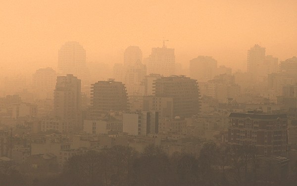
Tehran is located near two major fault lines. The city’s wide elevation range—from approximately 1,100 m above sea level in the southern plains to over 1,800 m in the northern suburbs—yields pronounced topographic micro-climates. Tehran suffers from severe air pollution, 80% of it due to cars. The remaining 20% is due to industrial pollution. Other estimates suggest that motorcycles account for 30% of air and 50% of noise pollution in Tehran. Tehran is considered one of the strongest sources of greenhouse gas emissions in the Middle East. Enhanced concentration of carbon dioxide over Tehran, that likely originate from the anthropogenic urban sources in the city, is easily detectable from satellite observations throughout the year. A plan to move the capital has been discussed many times in prior years, due mainly to the environmental issues of the region. In 2010, the government announced that "for security and administrative reasons, the plan to move the capital from Tehran has been finalized." There are plans to relocate 163 state firms and several universities from Tehran to avoid damages from a potential earthquake.
City officials are engaged in a battle to reduce air pollution. They have, for instance, encouraged taxis and buses to convert from petrol engines to compressed natural gas. The government has set up a "Traffic Zone" covering the city centre during peak traffic hours. Entering and driving inside this zone is only allowed with a special permit. There are efforts to raise people's awareness of the hazards of pollution. Pollution Indicator Boards have been installed all around the city to monitor the level of particulate matter (PM2.5/PM10), nitrogen dioxide (NO2), ozone (O3), sulfur dioxide (SO2), and carbon monoxide (CO).
Economy
Tehran is the economic centre of Iran. About 30% of Iran's public-sector workforce and 45% of its large industrial firms are located in the city, and almost half of these workers are employed by the government. Most of the remainder of workers are factory workers, shopkeepers, laborers, and transport workers.
Few foreign companies operate in Tehran, because of the government's complex international relations. But before the 1979 Revolution, many foreign companies were active in Iran. Tehran's present-day modern industries include the manufacturing of automobiles, electronics and electrical equipment, weaponry, textiles, sugar, cement, and chemical products. It is also a leading centre for the sale of carpets and furniture. The oil refining companies of Pars Oil, Speedy, and Behran are based in Tehran.
Tehran relies heavily on private cars, buses, motorcycles, and taxis, and is one of the most car-dependent cities in the world. The Tehran Stock Exchange, is a full member of the World Federation of Exchanges and a founding member of the Federation of Euro-Asian Stock Exchanges.
Fashion industry
Design, manufacturing, distribution, marketing, retail, advertising, and other sectors of the fashion industry in Tehran have been able to grow significantly according to the needs of the country. In particular, a large number of male and female models are working in Tehran's fashion advertising and promotion sections. Despite the lack of adequate laws to support models, payments to female models have been considered high. Also, modeling of children is usually prohibited in Tehran. Clothing manufacturers are closely related to other fashion sectors in Tehran. For example, the manufacturers of women's boots and bodysuits have strengthened their exports and branding in other countries by using this connection.
Shopping
Tehran has a wide range of shopping centers and is home to over 60 modern shopping malls. The city has a number of commercial districts, including those located at Valiasr, Davudie, and Zaferanie. The largest old bazaars are the Grand Bazaar and the Bazaar of Tajrish. Iran Mall is the largest mall in the world in area. Most of the international branded stores and upper-class shops are in the northern and western parts of the city. Tehran's retail business is growing with several newly built malls and shopping centres. Shoe (Mostly women's boots) manufacturing companies in Tehran can be reached in the malls.
Tourism
Main article: Tourism in Tehran

Tehran, as one of the main tourist destinations in Iran, has a wealth of cultural attractions. It is home to royal complexes of Golestan, Saadabad, and Niavaran, which were built under the reign of the country's last two monarchies. There are several historic, artistic, and scientific museums in Tehran, including:
- National Museum
- Malek Museum
- Cinema Museum at Ferdows Garden
- Abgineh Museum
- Museum of the Qasr Prison
- Carpet Museum
- Reverse Glass Painting Museum (vitray art)
- Safir Office Machines Museum
- Palestine Square Countdown Clock The Museum of Contemporary Art hosts works of famous artists such as Van Gogh, Pablo Picasso, and Andy Warhol. The Iranian Imperial Crown Jewels, one of the largest jewel collections in the world, are on display at Tehran's National Jewelry Museum. Several cultural and trade exhibitions take place in Tehran, which are mainly operated by the country's International Exhibitions Company. The annual International Book Fair is known to the international publishing world as one of the most important publishing events in Asia.
Infrastructure
Highways and streets
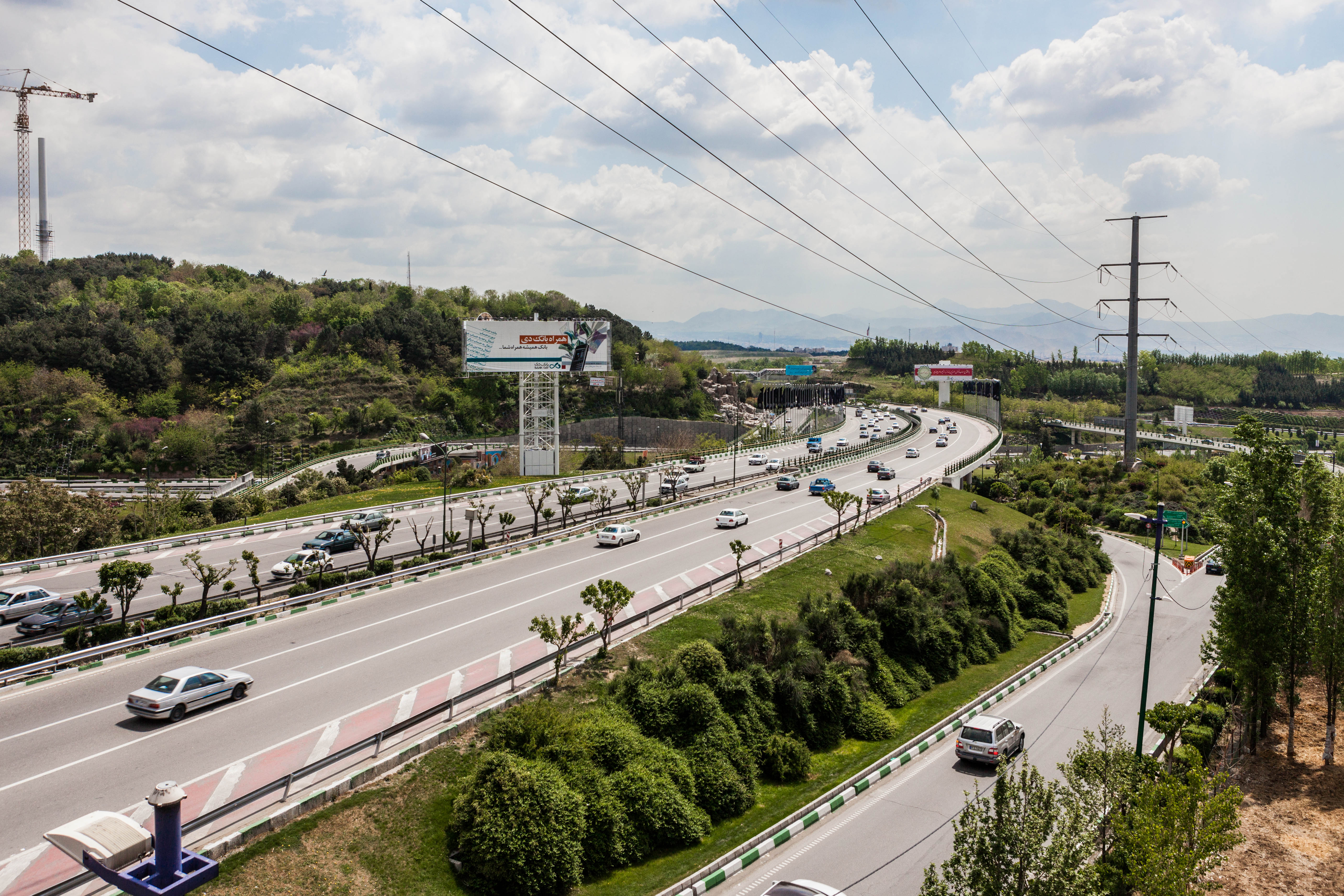
Following the Islamic Revolution in 1979, the political system changed from constitutional monarchy to Islamic republic. Then the construction of political power in the country needed to change so that new spectrums of political power and decision-making centers emerged in Iran. Motives, desires, and actions of these new political power decision-making centers in Iran made them rename streets and public places throughout the country, especially Tehran. For example Shahyad square changed to Azadi square and Pahlavi street changed to Valiasr street. The metropolis of Tehran is equipped with a large network of highways and interchanges.
According to the head of Tehran Municipality's Environment and Sustainable Development Office, Tehran was designed to have a capacity of about 300,000 cars, but more than five million cars are on the roads. The automotive industry has recently developed, but international sanctions influence the production processes periodically. According to local media, Tehran has more than 200,000 taxis plying the roads daily, with several types of taxi available in the city. Airport taxis have a higher cost per kilometer as opposed to regular green and yellow taxis in the city.
Buses
.jpg)
Buses have served the city since the 1920s. Tehran's transport system includes conventional buses, trolleybuses, and bus rapid transit (BRT). The city's four major bus stations include the South Terminal, the East Terminal, the West Terminal, and the northcentral Beyhaghi Terminal.
The trolleybus system was opened in 1992, using a fleet of 65 articulated trolleybuses built by Czech Republic's Škoda. This was the first trolleybus system in Iran. In 2005, trolleybuses were operating on five routes, all starting at Imam Hossein Square. Two routes running northeastwards operated almost entirely in a segregated busway located in the middle of the wide carriageway along Damavand Street, stopping only at purpose-built stops located about every 500 metres along the routes, effectively making these routes trolleybus-BRT (but they were not called such). The other three trolleybus routes ran south and operated in mixed traffic. Both route sections were served by limited-stop services and local (making all stops) services. A 3.2-kilometer extension from Shoosh Square to Rah Ahan Square was opened in March 2010. Visitors in 2014 found that the trolleybus system had closed, apparently sometime in 2013. However, it reopened in March 2016, operating on a single 1.8-km route between Meydan-e-Khorasan (Khorasan Square) and Bozorgrah-e-Be'sat. Around 30 vehicles had been refurbished and returned to service. Extensions were planned.
Tehran's bus rapid transit (BRT) was officially inaugurated in 2008. It has 10 lines with some 215 stations in different areas of the city. , the BRT system had a network of 100 km, transporting 1.8 million passengers on a daily basis.
Railway and subway
Tehran has a central railway station that connects services round the clock to various cities in the country, along with a Tehran–Europe train line also running. The feasibility study and conceptual planning of the construction of Tehran's subway system were started in the 1970s.
| Line | Opening | Length | Stations | Type |
|---|---|---|---|---|
| **[](tehran-metro-line-1)** | 2001 | 70 km | 32 | Metro |
| **[](tehran-metro-line-2)** | 2000 | 26 km | 22 | Metro |
| **[](tehran-metro-line-3)** | 2012 | 37 km | 24 | Metro |
| **[](tehran-metro-line-4)** | 2008 | 22 km | 22 | Metro |
| **[](tehran-metro-line-5)** | 1999 | 43 km | 11 | Commuter rail |
| **[](tehran-metro-line-6)** | 2019 | 9 km | 3 | Metro |
| **[](tehran-metro-line-7)** | 2017 | 13.5 km | 8 | Metro |
| **Metro Subtotal:** | **177.5 km** | **111** | ||
| **Total:** | **220.5 km** | **122** |
Airport
Tehran is served by the international airports of Mehrabad and Imam Khomeini. Mehrabad Airport, an old airport in western Tehran that doubles as a military base, is mainly used for domestic and charter flights. Imam Khomeini Airport, located 50 km south of the city, handles the main international flights.
Parks and green spaces
There are over 2,100 parks within the metropolis of Tehran, with one of the oldest being Jamshidie Park, which was first established as a private garden for Qajar prince Jamshid Davallu, and was then dedicated to the last empress of Iran, Farah Pahlavi. The total green space within Tehran stretches over 12,600 hectares, covering over 20 percent of the city's area. The Parks and Green Spaces Organization of Tehran was established in 1960, and is responsible for the protection of the urban nature present in the city.
Tehran's Birds Garden is the largest bird park in Iran. There is also a zoo located on the Tehran–Karaj Expressway, housing over 290 species within an area of about five hectares. In 2009, the Ab-o-Atash Park ("Water and Fire park") was founded. Its main features are an open water fountain area for cooling in the hot climate, fire towers, and an amphitheatre.
Energy
Greater Tehran is supplied by surface water from the Lar dam on the Lar River in the northeast of the city, the Latyan dam on the Jajrood River in the north, the Karaj River in the northwest, as well as by groundwater in the vicinity of the city. The city experiences stark water supply inequalities: impoverished districts struggle with inadequate water provision and hazardous water quality, while affluent areas are largely exempt from these hardships.
According to the national energy roadmap, the government plans to promote green technology to increase the nominal capacity of power plants from 74 gigawatts to over 120 gigawatts by the end of 2025. Solar panels have been installed in Pardisan Park for green electricity production, said Masoumeh Ebtekar, head of the Department of Environment.
Education
Tehran is the largest and most important educational center in Iran. There are a total of nearly 50 major colleges and universities in Greater Tehran. Since the establishment of Dar ol Fonun by the order of Amir Kabir in the mid-19th century, Tehran has amassed a large number of institutions of higher education. Some of these institutions have played crucial roles in the unfolding of Iranian political events. Samuel M. Jordan, whom Jordan Avenue in Tehran was named after, was one of the founding pioneers of the American College of Tehran, which was one of the first modern high schools in the Middle East. Tehran is home to Iran's largest military academy and several religious schools and seminaries.
Among major educational institutions located in Tehran, Amirkabir University of Technology (Tehran Polytechnic), University of Tehran, Sharif University of Technology, and Tehran University of Medical Sciences are the most prestigious. Other major universities located in Tehran include Tehran University of Art, Allameh Tabatabaei University, K. N. Toosi University of Technology, Shahid Beheshti University (Melli University), Kharazmi University, Iran University of Medical Sciences, Islamic Azad University, International Institute of Earthquake Engineering and Seismology, Iran's Polymer and Petrochemical Institute, Shahed University, and Tarbiat Modarres University. Sharif University of Technology, Amirkabir University of Technology, Iran University of Science and Technology and K. N. Toosi University of Technology also located in Tehran is nationally well known for taking in the top undergraduate Engineering and Science students; and internationally recognized for training competent undergraduate students. It has probably the highest percentage of graduates who seek higher education abroad.
Culture
Main article: Culture of Tehran
Iranian festivals are held in Tehran along with regional and western festivals. Nowruz, Chaharshanbe Suri, Sizdah Be-dar, Yaldā Night, Valentine's Day and Halloween have been popular festivals in recent decades.
Architecture
The oldest surviving architectural monuments are from the Qajar and Pahlavi eras. In Greater Tehran, monuments dating back to the Seljuk era remain as well; notably the Toqrol Tower in Ray. Rashkan Castle, dating back to the ancient Parthian Empire, of which some artifacts are housed at the National Museum; and the Bahram fire temple, which remains since the Sassanian Empire. Tehran only had a small population until the late 18th century but it began to take a more considerable role in Iranian society after it was chosen as the capital city. Despite the regular occurrence of earthquakes during the Qajar period and after, some historic buildings remain from that era. Tehran is Iran's primate city, and is considered to have the most modernized infrastructure in the country. However, the gentrification of old neighbourhoods and the demolition of buildings of cultural significance have caused concerns.
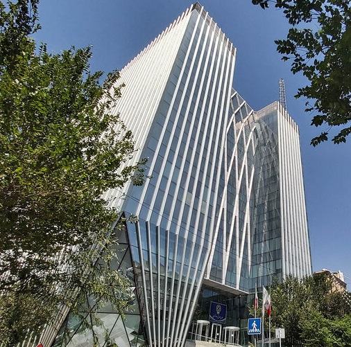
File:02 hasan abad Sq..jpg|Hasanabad Square File:Tehran City Theater 1.jpg|A view of the building of the City Theater of Tehran File:Iranian Foreign Affaire Ministry.jpg|Police House, the National Garden Tehran was previously a low-rise city because of seismic activity in the region, but modern high-rise developments have been built in recent decades to service its growing population. There have been no major quakes in Tehran since 1830. Tehran International Tower is the tallest skyscraper in Iran. It is 54-stories tall and located in the northern district of Yusef Abad. The Azadi Tower, a memorial built under the reign of the Pahlavi dynasty, has long been the most famous symbol of Tehran. Originally constructed in commemoration of the 2,500th year of the foundation of the Imperial State of Iran, it combines elements of the architecture of the Achaemenid and Sassanid eras with post-classical Iranian architecture. The Milad Tower, which is the sixth tallest tower and the 24th-tallest freestanding structure in the world, is the city's other famous landmark tower. Leila Araghian's Tabiat Bridge, the largest pedestrian overpass in Tehran, was completed in 2014 and is also considered a landmark.
Fashion and clothing
The city has produced many notable Iranian design houses and clothing companies. Fashion events are also held in some areas of the city. Many famous Iranian models were born in Tehran, including Nazanin Afshin-Jam, Cameron Alborzian, Sahar Biniaz, Elnaaz Norouzi, Shermine Shahrivar and Sadaf Taherian. Women of Tehran widely used over-the-knee and leather boots after 2000s.
Theater
Under the reign of the Qajars, Tehran was home to the royal theatre of Tekye Dowlat, located to the southeast of the Golestan Palace, in which traditional and religious performances were observed. It was eventually demolished and replaced with a bank building in 1947, following the reforms during the reign of Reza Shah.
Before the 1979 Revolution, the Iranian national stage had become the most famous performing scene for known international artists and troupes in the Middle East, with the Vahdat Hall, formerly but very much still known as Roodaki Hall (spelled in multiple ways in english), constructed to function as the national stage for opera and ballet. The hall was inaugurated in October 1967 and named after prominent Persian poet Rudaki. It is home to the Tehran Symphony Orchestra, the Tehran Opera Orchestra, and the Iranian National Ballet Company.
The City Theater of Tehran, one of Iran's biggest theatre complexes, which contains several performance halls, was opened in 1972. It was built at the initiative and presidency of Empress Farah Pahlavi, and was designed by architect Ali Sardar Afkhami, constructed within five years.
One of the gathering centers of cabarets in old Tehran was Laleh-Zar Street. Famous Persian cabarets were active in the city until 1979. They also introduced many domestic artists. In common language, cabaret was sometimes called "home of dance" or "dancing place".
The annual events of Fajr Theater Festival and Tehran Puppet Theater Festival take place in Tehran.
Cinema
The first movie theater in Tehran was established by Mirza Ebrahim Khan in 1904. Until the early 1930s, there were 15 theaters in Tehran province and 11 in other provinces. Most of the movie theatres are located downtown. The complexes of Kourosh Cinema, Mellat Gallery and Cineplex, Azadi Cinema, and Cinema Farhang are among the most popular cinema complexes in Tehran. Several film festivals are held in Tehran, including Fajr Film Festival, Children and Youth Film Festival, House of Cinema Festival, Mobile Film and Photo Festival, Nahal Festival, Roshd Film Festival, Tehran Animation Festival, Tehran Short Film Festival, and Urban Film Festival.
Music and dance
There are a variety of concert halls in Tehran. An organization like the Roudaki Culture and Art Foundation has five different venues where more than 500 concerts take place this year. Vahdat Hall, Roudaki Hall, Ferdowsi Hall, Hafez Hall and Azadi Theater are the top five venues in Tehran, where classical, pop, traditional, rock or solo concerts take place. Erotic dancers were active and trained in Tehran until the 1979 revolution. But after this date, because of the policies of the new government, these activities were completely banned.
Sports
Football and volleyball are the city's most popular sports, while wrestling, basketball, and futsal are also major parts of the city's sporting culture. Ice hockey and rugby are also popular. 12 ski resorts operate in Iran, the most famous being Tochal, Dizin, and Shemshak, all within one to three hours from the city of Tehran.
Tochal's resort is the world's fifth-highest ski resort at over 3730 m above sea level at its highest point. It is also the world's nearest ski resort to a capital city. The resort was opened in 1976, shortly before the 1979 Revolution. It is equipped with an 8 km gondola lift that covers a huge vertical distance. There are two parallel chair ski lifts in Tochal that reach 3900 m high near Tochal's peak, rising higher than the gondola's seventh station, which is higher than any of the European ski resorts. From the Tochal peak, there are views of the Alborz range, including the 5610 m Mount Damavand, a dormant volcano.
Tehran is the site of the national stadium of Azadi, the biggest stadium by capacity in West Asia, where many of the top matches of Iran's Premier League are held. The stadium is a part of the Azadi Sport Complex, which was originally built to host the 7th Asian Games in September 1974. This was the first time the Asian Games were hosted in West Asia. Tehran played host to 3,010 athletes from 25 countries/NOCs, which was at the time the highest number of participants since the inception of the Games. That followed hosting the 6th AFC Asian Cup in June 1976, and then the first West Asian Games in November 1997. The success of the games led to the creation of the West Asian Games Federation (WAGF), and the intention of hosting the games every two years. The city had also hosted the final of the 1968 AFC Asian Cup. Several FIVB Volleyball World League courses have also been hosted in Tehran. In 2014, the city hosted the FILA Wrestling World Cup event at the Azadi Indoor Stadium. File:Esteghlal Edges Past Persepolis 3-2 to Claim Tehran Derby-33.jpg|Tehran derby in Azadi Stadium. The match is considered one of the world's most intense derbies. File:Iran men's ice hockey league in Tehran.jpg|Iran's ice hockey league in Tehran File:Fitness training women M2 (babaea maryam Tehran 2018) 5.jpg|Horse riding in the west of the city File:مژگان بختیاری تی ار اکس ترینر و بدنساز حرفه ای بین المللی ایرانی در تمرینات استاندارد در باشگاه (5).jpg|One of the health clubs in the city File:Dizin, Iran.jpeg|Dizin, Iran's largest ski resort, is located near Tehran.
Food
There are many restaurants and cafes in Tehran, both modern and classic, serving both Iranian and cosmopolitan cuisine. Pizzerias, sandwich bars, and kebab shops make up the majority of food shops in Tehran.
Graffiti
Main article: Graffiti in Tehran
Many styles of graffiti are seen in Tehran. Some are political and revolutionary slogans painted by governmental organizations, and some are works of art by ordinary citizens, representing their views on both social and political issues. However, unsanctioned street art is forbidden in Iran, and such works are usually short-lived. During the 2009 Iranian presidential election protests, many graffiti works were created by people supporting the Green Movement. They were removed from the walls by the paramilitary Basij forces. In recent years, the Tehran Municipality has been using graffiti in order to beautify the city. Several graffiti festivals have also taken place in Tehran, including the one organized by the Tehran University of Art in October 2014.
Twin towns – sister cities
Tehran is twinned with:
-
ISR Jerusalem, Israel
-
TUR Ankara, Turkey
-
IRQ Baghdad, Iraq
-
CHN Beijing, China
-
KGZ Bishkek, Kyrgyzstan
-
BRA Brasília, Brazil
-
HUN Budapest, Hungary
-
VEN Caracas, Venezuela
-
CUB Havana, Cuba
-
AFG Kabul, Afghanistan
-
SUD Khartoum, Sudan
-
GBR London, England, United Kingdom
-
USA Los Angeles, United States
-
PHL Manila, Philippines
-
BLR Minsk, Belarus
-
RUS Moscow, Russia
-
RSA Pretoria, South Africa
-
YEM Sanaa, Yemen
-
BIH Sarajevo, Bosnia and Herzegovina
-
GEO Tbilisi, Georgia
-
ARM Yerevan, Armenia
-
KOR Seoul, South Korea
Notes
References
Bibliography
- Emerson, Charles. 1913: In Search of the World Before the Great War (2013) compares Tehran to 20 major world cities; pp. 309–24.
References
- "City of Tehran Statisticalyearbook".
- link. (17 November 2015 . Tehran.ir.)
- "Population of Tehran".
- data processed from www.amar.org.ir. (June 2025). "Estimated population in Iran by province". Iran Open Data (IOD).
- Marsi, Federica. (31 July 2024). "Israel war on Gaza updates: Fears of escalation grow after Haniyeh killing". [[Al Jazeera English]].
- Hassan. Habibi. fa. تاریخ تصویب (Approval date) 1369/06/21 (Iranian Jalali calendar). (12 September 1990 ). link. fa. لام تا کام [Lam ta Kam]. {{lang. fa. وزارت کشور [Ministry of the Interior]. fa. کمیسیون سیاسی دفاعی هیأت دولت [Political Defense Commission of the Government Board]. fa. شناسه [ID] B559F46F-4863-4D87-ACAB-5274C02BA3C5. {{lang. fa. شماره دوره [Course number] 69, {{lang. fa. شماره جلد [Volume number] 3.
- (12 January 2018). "Tehran's population doesn't fit its area: Environment official". Tehran Times.
- "Is Iran running out of water? – DW – 08/06/2025".
- "City population 2025".
- (27 November 2023). "About Tehran: Exploring the Area, Population, and Characteristics of Iran's Capital City".
- ''SI ee [[List of metropolitan areas in Asia]].''
- Erdösy, George.. (1995). "The Indo-Aryans of ancient South Asia: Language, material culture and ethnicity". Walter de Gruyter.
- "Tehran (Iran) : Introduction – Britannica Online Encyclopedia".
- (17 November 2014). "Tabiat Pedestrian Bridge / Diba Tensile Architecture". [[ArchDaily]].
- (30 September 2009). "The Fertility Transition in Iran: Revolution and Reproduction". Springer.
- Schuppe, Mareike.. (2008). "Coping with Growth in Tehran: Strategies of Development Regulation". GRIN Verlag.
- (14 October 2024). "When did tehran became capital?".
- (27 November 2023). "About Tehran: Exploring the Area, Population, and Characteristics of Iran's Capital City".
- "It's time we consider Iran's ethnic minorities".
- "The Situation of the Kurdish Community at Tehran, By H. S. Soran".
- "'Polite' and 'fair' Kurds dominate Tehran's fruit markets".
- "Gate of Tehran".
- Barbaglia, Pamela.. (29 March 2016). "Iranian expats hard to woo as Western firms seek a foothold in Iran". [[Reuters]].
- Erenhouse, Ryan.. (22 September 2016). "Bangkok Takes Title in 2016 Mastercard Global Destinations Cities Index". [[MasterCard]]'s newsroom.
- (6 October 2018). "Citizens of Capital Mark Tehran Day on October 6".
- Yahya, Zoka. (1978). "Karvand of Kasravi". Franklin.
- (15 November 2008). "A Research on Adaptation of Historic Urban Landscapes".
- (25 November 2023). "Tehran: national capital, Iran". [[Encyclopædia Britannica, Inc.]].
- John Allen Gay for [[The National Interest]], 27 May 2014. [https://nationalinterest.org/feature/when-did-peking-become-beijing-persia-become-iran-we-have-10525 "When Did Peking Become Beijing and Persia Become Iran? We Have the Data"], with the [[Google Books Ngram Viewer]] graph [https://books.google.com/ngrams/graph?content=Tehran%2CTeheran&year_start=1800&year_end=2008&corpus=15&smoothing=0&share=&direct_url=t1%3B%2CTehran%3B%2Cc0%3B.t1%3B%2CTeheran%3B%2Cc0 here]. Accessed 12 December 2023.
- "Tehrān - History".
- "Al-Rayy".
- (2005). "Birth of the Persian Empire". I.B. Tauris.
- A. Tafazolli, "In Iranian Mythology" in Encyclopædia Iranica
- (Bulddan, Yackubl, 276)
- {{cite EB1911
- Amanat, Abbas. (1997). "Pivot of the Universe: Nasir Al-Din Shah Qajar and the Iranian Monarchy, 1831–1896". [[University of California Press]].
- Dowling, Timothy C.. (2 December 2014). "Russia at War: From the Mongol Conquest to Afghanistan, Chechnya, and Beyond". [[ABC-CLIO]].
- (2007). "Who Was Who".
- (25 August 1922). "The Statesman's Year-Book". Palgrave Macmillan.
- (2010). "Baedeker & Cook – Tourismus am Mittelrhein 1756 bis ca. 1914".
- (1913). "Britannica year-book, 1913 - a survey of the world's progress since the completion in 1910 of the Encyclopaedia Britannica".
- (February 2013). "Spatial Discrimination in Tehran's Modern Urban Planning 1906–1979". Journal of Planning History.
- Shirazian, Reza, Atlas-i Tehran-i Qadim, Dastan Publishing House: Tehran, 2015, P. 11
- [[Mohammad-Taqi Bahar. Bahar, Mohammad Taghi]] (1992). A brief history of political parties in Iran: the extinction of the Qajar dynasty. J. First. Amir Kabir Publications. {{ISBN. 9789640005965
- "جنگهای جهانی".
- "نگاهي به تاريخ تهران در دوران قاجار و پهلوي /از دارالخلافه ناصري تا تهران مدرن".
- (2009). "Town and Country in the Middle East: Iran and Egypt in the Transition to Globalization". Lexington Books.
- "Ideology and Iran's Revolution: How 1979 Changed the World".
- "1979: Iran and America".
- Amirahmadi, Hooshang. (1990). "Economic Reconstruction of Iran: Costing the War Damage". Third World Quarterly.
- (2025-05-22). "Iranian Revolution - Aftermath, Reforms, Legacy {{!}} Britannica".
- (2020-05-17). "Tehran: An Introduction – Approaches to the Modern City".
- Sedighi, Mohamad. (2018-04-12). "Megastructure Reloaded: A New Technocratic Approach to Housing Development in Ekbatan, Tehran". ARENA Journal of Architectural Research.
- (4 December 2015). "Tehran Urban Reforms Between Two Revolutions Developmentalism, Worlding Urbanism and Neoliberalism".
- Vanstiphout, Wouter. "The Saddest City in the World". The New Town.
- "پیام ما؛ رسانه توسعه پایدار ایران | تهران با نخل دبی نمیشود".
- Motamedi, Maziar. "Shock, fear in Tehran after Israel bombs residential, military areas".
- Hafezi, Parisa. (2025-06-16). "Iranians flee capital for safety as Israeli airstrikes intensify". Reuters.
- Caldero, Rocco. (2025-06-15). "Mass Exodus Grips Tehran as Israeli Strikes and Warnings Spark Panic".
- "Exodus, shortages and strikes: Tehran reels under weight of Israel-Iran war - AL-Monitor: The Middle Eastʼs leading independent news source since 2012".
- fa. مرکز آمار ایران [Statistical Centre of Iran]. link
- link. fa. مرکز آمار ایران [Statistical Centre of Iran]
- fa. مرکز آمار ایران [Statistical Centre of Iran]. link
- (1991). "Central Dialects". Routledge.
- (December 1987). "Iran-Azeris". [[Library of Congress Country Studies]].
- (2005). "Country Study Guide-Azerbaijanis". STRATEGIC INFORMATION AND DEVELOPMENTS-USA.
- (3 April 2016). "یک و نیم میلیون مازندرانی پایتخت نشین شدند". [[Islamic Republic News Agency.
- (3 November 2010). "چنددرصد تهرانیها در تهران به دنیا آمدهاند؟".
- Asadzade, Peyman. (28 February 2019). "Faith or Ideology? Religiosity, Political Islam, and Anti-Americanism in Iran". [[Journal of Global Security Studies]].
- Lakshman, Nikhil. "Indian Prime Minister in Tehran".
- (9 May 1993). "Iran Lightens Up On Western Ways". [[Chicago Tribune]].
- Buzbee, Sally. [https://www.washingtonpost.com/wp-dyn/content/article/2007/10/04/AR2007100401405_pf.html "Tehran: Split Between Liberal, Hard-Line"] {{Webarchive. link. (6 August 2017 . [[Associated Press]] via ''[[The Washington Post]]''. Thursday 4 October 2007.)
- Hundley, Tom. [http://www.accessmylibrary.com/coms2/summary_0286-8331982_ITM "Pro-reform Khatami appears victorious after 30 million Iranians cast votes"]. ''[[Chicago Tribune]]''. 8 June 2001.
- Tools, Free Map. "Elevation Finder".
- Labzovskii, Lev. (2 August 2019). "Working towards confident spaceborne monitoring of carbon emissions from cities using Orbiting Carbon Observatory-2". Remote Sensing of Environment.
- "Tehran Geography".
- "Institute for Iranian Contemporary Historical Studies".
- [https://www.hamshahrionline.ir/photo/173606/آشنایی-با-دریاچه-شهدای-خلیج-فارس-چیتگر-تهران/Chitgar lake (in Persian)] {{Webarchive. link. (9 December 2022 . hamshahrionline.ir)
- Harrison, Frances. (19 February 2005). "Iran gripped by wintry weather". BBC News.
- "Heavy Snowfall in Tehran".
- [https://web.archive.org/web/20080208071157/http://www1.irna.com/fa/news/view/line-2/8610166477213215.htm/ Heavy Snowfall in Tehran (in Persian)]. irna.com
- "Rare snow blankets Iran's capital Tehran". BBC News.
- (3 June 2014). "Deadly Dust Storm Engulfs Iran's Capital".
- (2025-08-10). "As summer temperatures soar, Iran's water crisis worsens".
- (2025-08-05). "Scorching heat in Iran forces closure of public buildings, banks". Reuters.
- Scott, LaToya. (2025-07-31). "Tehran's 10 million residents face a dire water crisis {{!}} CNN".
- "Monthly Total Precipitation in Tehran(Jeophysics by Month 1991–2005". Iran Meteorological Organization.
- (August 2023). "Average relative humidity in Tehran by Month 1951–2010". Iran Meteorological Organization}} {{dead link.
- (August 2023). "No. Of days with precipitation in Tehran by Month 1951–2010". Iran Meteorological Organization}} {{dead link.
- (August 2023). "Monthly total sunshine hours in Tehran by Month 1951–2010". Iran Meteorological Organization}} {{dead link.
- "World Meteorological Organization Climate Normals for 1991-2020: TehranMehrabadAirport-40754". [[NOAA]].
- "WMO Climate Normals for 1981-2010: Tehran (Mehrabad airport)". [[NOAA]].
- "Form 32: No. Of days with snow or sleet Station: Tehran Mehrabad(40754)". Iran Meteorological Organization.
- "Tehran, Iran - Detailed climate information and monthly weather forecast".
- [http://www.chaharmahalmet.ir/iranarchive.asp I.R. of Iran Shahrekord Meteorlogical Organization (in Persian)] {{Webarchive. link. (29 August 2017. 1988–2020)
- [http://www.data.irimo.ir/ I.R. of Iran Shahrekord Meteorlogical Organization (in Persian)] {{Webarchive. link. (29 May 2020. 1988–2020)
- (22 November 2006). "Car exhaust fumes blamed for over 80% of air pollution in Tehran".
- (22 November 2006). "Motorcycles Account for 30% of Air Pollution in Tehran".
- "For Security and Administrative [sic] Reasons: Plan to Move Capital From Tehran Finalized".
- (22 November 2006). "Iran Moots Shifting Capital from Tehran".
- "Tehran (Iran): People – Britannica Online Encyclopedia".
- Cordesman, Anthony H.. (23 September 2008). "The US, Israel, the Arab States and a Nuclear Iran. Part One: Iranian Nuclear Programs". Center for Strategic and International Studies.
- (2009). "Town and Country in the Middle East: Iran and Egypt in the Transition to Globalization". Lexington Books.
- (6 August 2003). "Iran blocks share price gains". BBC News.
- (2020). "تاریخچه صنعت مد، پوشاک و شبکه توزیع وابسته در جهان و ایران (چاپ نخست)".
- Gulf News. (9 June 2017). "Hopes for shopping revolution as malls sprout in Iran".
- "THE 10 BEST Tehran Shopping Malls (with Photos)".
- (27 September 2021). "Top 10 Biggest Shopping Malls In The World 2022".
- "کتابشناسى و راهنماى صناىع دستى کشور - Page 177, 180".
- "Tehran International Book Fair".
- M, Badiei Azandehi. (1 January 2009). "The Discourse of Streets' Naming in Tehran After Islamic Revolution". Geopolitics Quarterly.
- (19 December 2015). "Smogglarm i många världsstäder". Göteborgs-Posten.
- (22 November 2006). "'Tehran's overpopulation will cause ecological ruin'".
- (19 December 2017). "Getting a cab in Tehran: Airport Taxis". Living in Tehran.
- Murray, Alan (2000). ''World Trolleybus Encyclopaedia'', pp. 57 and 99. Yateley, Hampshire, UK: Trolleybooks. {{ISBN. 0-904235-18-1.
- ''Trolleybus Magazine'' No. 265 (January–February 2006), pp. 16–17. National Trolleybus Association (UK). {{issn. 0266-7452.
- ''Trolleybus Magazine'' No. 298 (July–August 2011), pp. 89–90. National Trolleybus Association (UK).
- Haseldine, Peter (March–April 2015). "Tehran Closure". ''Trolleybus Magazine'' No. 320, pp. 40–43. National Trolleybus Association (UK). {{issn. 0266-7452.
- ''Trolleybus Magazine'' No. 328 (July–August 2016), pp. 118–119. National Trolleybus Association (UK).
- Budach, D.. (11 July 2016). "Teheran: Trolleybuses return!".
- "About Metro - Metro History". Tehran Urban & Suburban Railway Operating Company.
- (20 June 2011). "Development of stations operating". Tehran Urban & Suburban Railway Operating Company.
- "خط ۱ مترو تهران و توسعه شمالي و جنوبي خط تا كهريزك".
- "Stations".
- "خط 2 متروي تهران و توسعه شرقي خط تا پايانه شرق".
- "خط 3 مترو تهران".
- "خط 4 مترو تهران".
- "خط 5 مترو".
- "Final profile Tehran Metro Station Line 5". Tehran Urban & Suburban Railway Operating Company.
- (7 April 2019). "Tehran Metro Line 6 Opens". Financial Tribune.
- Barrow, Keith. "Tehran metro Line 7 inaugurated".
- (15 February 2015). "Mokhtari: There are over 2,100 parks in Tehran". [[IRNA]].
- "About Tehran Parks & Green Space Organization". Municipality of Tehran.
- "The Tehran Zoological Garden". ITTO.
- "Ab-o Atash Park (Water and Fire Park - Ibrahim Park)".
- (2022). "An assessment of the correlation between urban green space supply and socio-economic disparities of Tehran districts—Iran". Environment, Development and Sustainability.
- (16 October 2016). "Tehran Park Gets Solar Panels".
- "فرهنگ عامه مردم تهران - ۹۸".
- Karimian, Hossein. (January 2020). "Ancien Rey".
- "A guide to Iran – etiquette, customs, clothing and more…".
- Urschel, Donna. "The Style of Tehran – Library of Congress".
- (19 April 2010). "Women to blame for earthquakes, says Iran cleric". The Guardian.
- (n.d.). "Milad Tower, a perfect product for a perfect project". NBN (Nasl Bartar Novin).
- Andrew Burke, Mark Elliott. ''Iran (Lonely Planet Country Guide)''. p. 114. Lonely Planet Publications, 5th Edition, 2008. {{ISBN. 978-1-74104-293-1.
- "ششمین نمایشگاه ایران مد از فردا آغاز میشود".
- "Fashion Fads History V2 -Persia-, p.171,172,176.".
- Kiann, Nima. (2015). "The History of Ballet in Iran". Reichert Verlag.
- Entekhab.ir, پایگاه خبری تحلیلی انتخاب {{!}}. (29 May 2023). "گزارشی از شب های تهران ۴۷ سال پیش / آمارهای قابل توجه درمورد تهرانی ها و خرج هایی که صرف خوشگذرانی می کردند".
- Mehrabi, Massoud.. "The history of Iranian cinema".
- (November 1999). "Iranian Cinema: Before the Revolution".
- "Tehran Day Tour {{!}} Concert in Tehran - HiPersia".
- "Lines of Telecabin".
- "TEHRAN 1974".
- Stokkermans, Karel. (22 January 2015). "West Asian Games".
- "Iran to host 2014 FILA Greco-Roman World Cup - Sports news".
- (27 July 2015). "Tehran Food Guide". The City Lane.
- Cheragh Abadi, Mehrnoush.. (10 February 2017). "The fleeting freedom of street art in Tehran". Equal Times.
- (2 March 2010). "Tehran's graffiti war". [[France 24]].
- (24 October 2012). "دانشگاه هنر میزبان فستیوال گرافیتی". Deutsche Welle.
- (21 March 2018). "گذری بر خواهرخوانده تهران در شرق اروپا". Iranian Students' News Agency.
- (16 February 2017). "The Twin Cities of Oxford, Cambridge and London". Oxford Royale Academy.
- "Sister Cities of Los Angeles".
- "Twin towns of Minsk". Minsk.
- "Gradovi pobratimi: Spisak". Sarajevo.
- "Sister and Friendship Cities". Seoul.
This article was imported from Wikipedia and is available under the Creative Commons Attribution-ShareAlike 4.0 License. Content has been adapted to SurfDoc format. Original contributors can be found on the article history page.
Ask Mako anything about Tehran — get instant answers, deeper analysis, and related topics.
Research with MakoFree with your Surf account
Create a free account to save articles, ask Mako questions, and organize your research.
Sign up freeThis content may have been generated or modified by AI. CloudSurf Software LLC is not responsible for the accuracy, completeness, or reliability of AI-generated content. Always verify important information from primary sources.
Report