From Surf Wiki (app.surf) — the open knowledge base
Taklamakan Desert
Desert in Xinjiang, China

Desert in Xinjiang, China
| Field | Value |
|---|---|
| name | Taklamakan Desert |
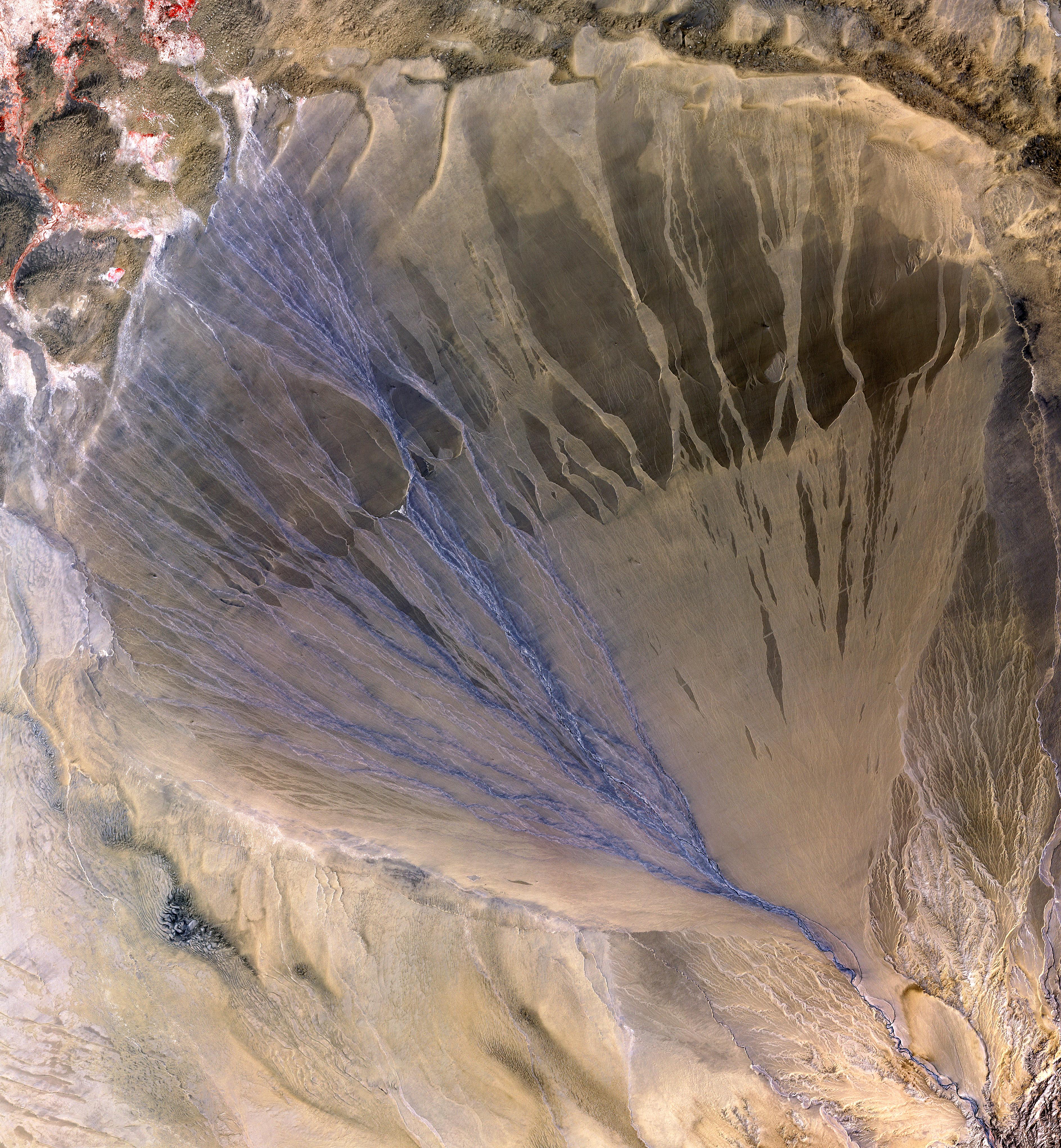
| photo | Taklamakan desert.jpg |
| photo_caption | View of the Taklamakan desert |
| map_image | Tarimrivermap.png |
| map_caption | Taklamakan Desert and Tarim Basin |
| country | China |
| region | Xinjiang |
| area_km2 | 337000 |
| coordinates | |
| s | 塔克拉玛干沙漠 |
| t | 塔克拉瑪干沙漠 |
| p | Tǎkèlāmǎgān Shāmò |
| poj | Thah-khek-lá-má-kan Soa-bo̍k |
| w | Tʻa³-kʻo⁴-la¹-ma³-kan¹ Sha1-mo4 |
| xej | تَاكْلامَاقًا شَاموْ |
| dungan | Такәламаган Шамә |
| uig | تەكلىماكان قۇملۇقى |
| uly | Teklimakan qumluqi |
| uyy | Təklimakan ⱪumluⱪi |
| usy | Тәклимакан қумлуқи |
The Taklamakan Desert ( ) is a desert in northwest China. Located inside the Tarim Basin in Southern Xinjiang, it is bounded by the Kunlun Mountains to the south, the Pamir Mountains to the west, the Tian Shan range to the north, and the Gobi Desert to the east.
Etymology
While most researchers agree on makan being the Persian word for "place", etymology of Takla is less clear. The word may be a Uyghur borrowing of the Persian tark, "to leave alone/out/behind, relinquish, abandon" + makan. Another plausible explanation suggests it is derived from Turki taqlar makan, describing "the place of ruins". Chinese scholars Wang Guowei and Huang Wenbi linked the name to the Tocharians, a historical people of the Tarim Basin, making the meaning of "Taklamakan" similar to "Tocharistan". According to Uyghur researcher Turdi Mettursun Kara, the name Taklamakan comes from the expression Terk-i Mekan. The name is first mentioned as Terk-i Makan (ترك مكان / trk mkan) in the book called Tevarih-i Muskiyun, which was written in 1867 in the Hotan Prefecture of Xinjiang.
In folk etymology, it is said to mean "Place of No Return" or "get in and you'll never get out".
Geography

The Taklamakan Desert has an area of 337000 km2, making it slightly smaller than Germany. The desert is part of the Tarim Basin, which is 1000 km long and 400 km wide. It is crossed at its northern and at its southern edge by two branches of the Silk Road, by which travellers sought to avoid the arid wasteland. It is the world's second-largest shifting sand desert, with about 85% made up of shifting sand dunes,{{cite encyclopedia |url=http://www.britannica.com/eb/article-9110530/Takla-Makan-Desert |title=Taklamakan Desert |encyclopedia=Encyclopædia Britannica |access-date=August 11, 2007 |archive-url=https://web.archive.org/web/20070929204252/http://www.britannica.com/eb/article-9110530/Takla-Makan-Desert |archive-date=September 29, 2007 |url-status=live}} ranking 16th in size in a ranking of the world's largest deserts.{{cite web
The People's Republic of China has constructed two cross-desert highways. The Tarim Desert Highway links the cities of Hotan (on the southern edge) and Luntai (on the northern edge) and the Bayingol to Ruoqiang road crosses the desert to the east.
As a shifting sand desert, sand dunes constantly shift under the influence of the wind. As a result, moving sand dunes erode grasslands and residential areas.
The Golmud-Korla Railway crosses the Taklamakan as well.
Named areas in the desert include Ha-la-ma, A-lang-ha and Mai-k'o-tsa-k'o. The Mazartag mountains are located in the western part of the desert.
Green belt
In 1978, the Chinese government launched the Green Great Wall project, aiming to create a forest chain extending from Xinjiang to Heilongjiang in northern China, to prevent desertification as well as harness the region's renewable energy potential. It is one of the largest afforestation projects in the world. By 2024, a 3,050-kilometre (1,900-mile) green belt had been completed, encircling the desert with sand-stabilizing vegetation and solar-powered sand control systems.
The project involved planting desert poplar, saxaul, and red willow trees, particularly in southern areas like Yutian County. These efforts aim to reduce sandstorms, protect infrastructure, and improve ecological stability.
The initiative complements infrastructure developments such as the Hotan–Ruoqiang railway, the first railway loop around a desert and large-scale renewable energy projects. Plans by the China Three Gorges Corporation include the construction of 8.5 gigawatts of solar power and 4 gigawatts of wind energy generation capacity in the region.
Climate


Because it lies in the rain shadow of the Himalayas, the Taklamakan has a cold desert climate. Given its relative proximity with the cold to frigid air masses in Siberia, extreme temperatures are recorded in wintertime, sometimes well below −20 C, while in summer they can rise up to 40 C. During the 2008 Chinese winter storms episode, the Taklamakan was reported to be covered, for the first time in its recorded history, entirely with a thin layer of snow, reaching 4 cm, with a temperature of −26.1 C in some observatories.{{cite news |access-date=February 4, 2008 |archive-url=https://web.archive.org/web/20080208090206/http://news.xinhuanet.com/english/2008-02/01/content_7544946.htm |archive-date=February 8, 2008
Its extreme inland position, effectively at the very center of Asia, and thousands of kilometres from any open body of water, accounts for its somewhat wide diurnal temperature variation.
Spring dust storms
Spring, when wind patterns shift and the especially dry land with minimal vegetation warms rapidly, is peak dust storm season, especially in the southern part of the desert. The sun heats near-surface dust, fueling pockets of convection. Satellite observations by the Japanese Himawari-9 show the dust creeping upward in mountain valleys throughout the day. Data from NASA's MODIS instruments show 1.5% decrease in the amount of atmospheric dust in the area each year since the early 2000s.
|Jan record high C = 16.3 |Jan record low C = -32.6 |Feb record high C = 17.2 |Feb record low C = -32.7 |Mar record high C = 32.7 |Mar record low C = -12.3 |Apr record high C = 37.0 |Apr record low C = -8.3 |May record high C = 38.2 |May record low C = 1.2 |Jun record high C = 41.6 |Jun record low C = 7.2 |Jul record high C = 45.6 |Jul record low C = 11.1 |Aug record high C = 42.7 |Aug record low C = 6.8 |Sep record high C = 39.5 |Sep record low C = 0.6 |Oct record high C = 31.9 |Oct record low C = -8.4 |Nov record high C = 24.7 |Nov record low C = -18.0 |Dec record high C = 16.7 |Dec record low C = -24.7
Oasis
_p61_PLATE19._SINKIANG_(14597194848).jpg)
The Taklamakan Desert has very little water, making it hazardous to cross. Merchant caravans on the Silk Road would stop for relief at its thriving oasis towns.{{cite book |access-date=August 7, 2007 |author-link=Peter Hopkirk |archive-url=https://web.archive.org/web/20170109085828/https://books.google.com/books?id=1_41VGoCYU8C&pg=PA321&dq=Taklamakan+Desert |archive-date=January 9, 2017 |url-status=live
The key oasis towns, watered by rainfall from the mountains, were Kashgar, Miran, Niya, Yarkand, and Khotan (Hetian) to the south, Kuqa and Turpan in the north, and Loulan and Dunhuang in the east. Now, many sites, such as Miran and Gaochang, stand in ruins, and encompass sparsely inhabited zones in the modern Xinjiang Autonomous Region of the People's Republic of China.{{cite book |access-date=August 25, 2007 |author-link=Susan Whitfield |archive-date=May 9, 2016 |url-status=live
Numerous archaeological treasures have been found in the sand-buried ruins of the Taklamakan. They point to Tocharian, early Hellenistic, Indian, and Buddhist influences. Its treasures and dangers have been vividly described by Aurel Stein, Sven Hedin, Albert von Le Coq, and Paul Pelliot.{{cite web |access-date = August 7, 2007 |archive-url = http://arquivo.pt/wayback/20160315145417/http://www.ess.uci.edu/%7Eoliver/silk.html |archive-date = March 15, 2016 Mummies, some dated to as far back as 4000 years, have been found in the region.{{cite news |access-date=December 28, 2014 |archive-url=https://web.archive.org/web/20141228211020/http://www.nytimes.com/2010/03/16/science/16archeo.html |archive-date=December 28, 2014 |url-status=live
Later, the Taklamakan was inhabited by Turkic peoples. The Indo-European-speaking Tocharians were assimilated by the Turkic Uyghurs who migrated into the Tarim Basin around the 9th century. Starting with the Han dynasty, the Chinese sporadically extended their control to the oasis cities of the Taklamakan Desert to control important silk road trade routes across Central Asia. Periods of Chinese rule were interspersed with rule by Turkic, Mongol and Tibetan peoples. The present population consists largely of Turkic Uyghur people and ethnic Han Chinese.
Scientific exploration
This desert was explored by several scholars, including Xuanzang, a 7th-century Buddhist monk, and, in the 20th century, the archaeologist Aurel Stein.
Atmospheric studies have shown that dust originating from the Taklamakan is blown over the Pacific, where it contributes to cloud formation over the Western United States. Further, the traveling dust redistributes minerals from the Taklamakan to the western U.S. via rainfall. Studies have shown that a specific class of mineral found in the dust, known as K-feldspar, triggers ice formation particularly well. K-feldspar is particularly susceptible to corrosion by acidic atmospheric pollution, such as nitrates and phosphates; exposure to these constituents reduces the ability of the dust to trigger water droplet formation.
In May 2023, China announced that it would drill a hole to around 11 km depth to investigate the layers of crust in that area. It will not be as deep as the Kola Superdeep Borehole (12,262 metre.
Transportation
Main article: Tarim Basin#Roads and Transportation
The Taklamakan Desert is surrounded by the Taklamakan Desert railway loop. The Southern Xinjiang Railway branches from the Lanxin Railway near Turpan, follows the north side of the basin to Kashgar, and curves southeast to Khotan, while Hotan–Ruoqiang railway loops around the south and west side of the rail line. In total, the Taklamakan Desert railway loop contains four different railway lines, including the sections of the Golmud–Korla railway, Hotan–Ruoqiang railway, Kashgar–Hotan railway, and Southern Xinjiang railway. Roads and highways are also available in the desert.
In popular culture
The desert is the main setting for Chinese film series Painted Skin and Painted Skin: The Resurrection. The Chinese TV series Candle in the Tomb is mostly spent in this desert as they are searching for the Niya ruins.
The issue No. 39 Soft Places of Neil Gaiman's The Sandman takes place in the desert, when Marco Polo gets lost in the desert.
A portion of the Korean quasi-historical TV drama series Queen Seondeok takes place in the Taklamakan Desert. Sohwa escapes from Silla with baby Deokman and raises her in the desert. As a teenager, Deokman returns to Silla and uses the knowledge and experience gained from life among international traders in the Taklamakan trading centers to gain the throne of Silla.
The desert is showcased in the Japanese animation Mobile Suit Gundam 00, set in the year 2307. On the series, the Taklamakan Desert is the setting of a large-scale military joint operation performed by all the world's blocks of power, and interdicted by the paramilitary organization Celestial Being.
References
Citations
Sources
- Kara, Turdi Mettursun (March 1, 2022). ""Taklamakan" Adının Kökeni Üzerine". Korkut Ata Türkiyat Araştırmaları Dergisi (7): 572–577. doi:10.51531/korkutataturkiyat.1070366. ISSN 2687-5675. S2CID 248487312.
- Jarring, Gunnar (1997). "The toponym Takla-makan", Turkic Languages, Vol. 1, pp. 227–240.
- Hopkirk, Peter (1980). Foreign Devils on the Silk Road: The Search for the Lost Cities and Treasures of Chinese Central Asia. Amherst: The University of Massachusetts Press. .
- Hopkirk, Peter (1994). The Great Game: The Struggle for Empire in Central Asia. .
- Tamm, Eric Enno (2010). The Horse That Leaps Through Clouds. Vancouver/Toronto/Berkeley: Douglas & McIntyre. (cloth); (ebook).
- Warner, Thomas T. (2004). Desert Meteorology. Cambridge University Press, 612 pages. .
Videography
- Treasure seekers : China's frozen desert, National Geographic Society (2001)
References
- Pospelov, E. M.. (1998). "Geograficheskiye nazvaniya mira".
- Jarring, Gunnar. (1997). "The Toponym Taklma-makan". Turkic Languages.
- Tamm (2011), p. 139.
- "Takla Makan Desert at TravelChinaGuide.com".
- (2019). "Origin and meaning of the name "Taklamakan" [塔克拉玛干之名的起源与语义]". Wenhui Xueren.
- Kara, Turdi Mettursun. (March 1, 2022). ""Taklamakan" Adının Kökeni Üzerine". Korkut Ata Türkiyat Araştırmaları Dergisi.
- Golden, Peter B.. (January 14, 2011). "Central Asia in World History". Oxford University Press.
- Hobbs, Joseph J.. (December 14, 2007). "World Regional Geography". Wadsworth Publishing Co Inc.
- Baumer, Christoph. (June 30, 2008). "Traces in the Desert: Journeys of Discovery Across Central Asia". B. Tauris & Company.
- Hopkirk, Peter. (November 1, 2001). "Foreign Devils on the Silk Road: The Search for the Lost Treasures of Central Asia". Oxford University Press.
- (2006). "The Age of the Taklamakan Desert". [[Science (journal).
- Ban, Paul G.. (2000). "The Atlas of World Archeology". Check mark Books.
- (27 May 2013). "Holding back the sands of time".
- (1971). "NJ 44 Ho-tien [China, India] Series 1301, Edition 3-TPC". [[U.S. Army Topographic Command]].
- Stanway, David. (November 29, 2024). "China completes 3,000-km green belt around its biggest desert, state media says". Reuters.
- Sinha, Sujita. "China tames world's 2nd largest sand-shifting desert with solar wall".
- (2021). "Characteristics of dust aerosols and identification of dust sources in Xinjiang, China". Atmospheric Environment.
- (April 4, 2025). "A Curtain of Dust Over the Tarim Basin".
- (January 21, 2020). "A Decline in Asian Dust".
- link. [[China Meteorological Administration]]
- "38°53'28.0"n 82°10'40.0"e".
- [https://www.bbc.com/news/world-asia-pacific-16860974 Xinjiang territory profile] {{Webarchive. link. (July 1, 2018 , BBC News. May 7, 2011.)
- Fox, Douglas. (December 22, 2014). "The Dust Detectives".
- (June 2013). "The importance of feldspar for ice nucleation by mineral dust in mixed-phase clouds". Nature.
- [https://www.indiatoday.in/science/story/china-begins-drilling-a-10-kilometer-deep-hole-in-earths-crust-2386983-2023-05-31 China begins drilling a 10-kilometer-deep hole in Earth's crust], [[India Today]], May 31, 2023
- Zhang, Kate. (June 17, 2022). "New railway completes 2,700km loop of Taklamakan Desert in move to integrate Xinjiang with rest of China".
!["NJ 44 Ho-tien [China, India] Series 1301, Edition 3-TPC"](http://legacy.lib.utexas.edu/maps/imw/txu-oclc-6654394-nj-44-3rd-ed.jpg)
This article was imported from Wikipedia and is available under the Creative Commons Attribution-ShareAlike 4.0 License. Content has been adapted to SurfDoc format. Original contributors can be found on the article history page.
Ask Mako anything about Taklamakan Desert — get instant answers, deeper analysis, and related topics.
Research with MakoFree with your Surf account
Create a free account to save articles, ask Mako questions, and organize your research.
Sign up freeThis content may have been generated or modified by AI. CloudSurf Software LLC is not responsible for the accuracy, completeness, or reliability of AI-generated content. Always verify important information from primary sources.
Report