From Surf Wiki (app.surf) — the open knowledge base
Sunbury County, New Brunswick
County in New Brunswick, Canada
County in New Brunswick, Canada
| Field | Value |
|---|---|
| name | Sunbury |
| settlement_type | County |
| image_map | Map of New Brunswick highlighting Sunbury County.png |
| map_caption | Location within New Brunswick. |
| subdivision_type | Country |
| subdivision_name | Canada |
| subdivision_type1 | Province |
| subdivision_name1 | New Brunswick |
| established_title | Established |
| established_date | 1785 |
| area_footnotes | |
| area_land_km2 | 2,692.97 |
| population_as_of | 2021 |
| population_footnotes | |
| population_total | 27,864 |
| population_density_km2 | 10.3 |
| population_blank1_title | Change |
| 2016-2021 | |
| population_blank1 | 0.8% |
| population_blank2_title | Dwellings |
| population_blank2 | 11,903 |
| timezone | AST |
| utc_offset | -4 |
| timezone_DST | ADT |
| utc_offset_DST | -3 |
| area_code | 506 |
2016-2021
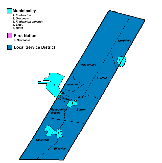
Sunbury County (2021 population 27,864) is located in central New Brunswick, Canada. A large military base (CFB Gagetown) is located in the western part of the county south of the town of Oromocto. The county also hosts forestry and mixed farming. Burton is the county shire town.
Census subdivisions
Communities
There are three municipalities within Sunbury County (listed by 2016 population):
| Official name | Designation | Area km2 | Population | Parish |
|---|---|---|---|---|
| Oromocto | Town | 22.44 | 9,223 | Burton |
| Fredericton Junction | Village | 23.85 | 704 | Gladstone |
| Tracy | Village | 29.46 | 608 | Gladstone |
Much of the Village of Minto lies within Sunbury County, but since most of it is in Queens County, Statistics Canada considers it as part of Queens. Similarly, a small portion of the city of Fredericton lies within Sunbury County, but is counted as part of York.
First Nations
There is one First Nations reservation in Sunbury County (listed by 2016 population):
| Official name | Designation | Area km2 | Population | Parish |
|---|---|---|---|---|
| Oromocto 26 | Reservation | 0.31 | 282 | Burton |
Parishes
The county is subdivided into seven parishes (listed by 2016 population):
| Official name | Area km2 | Population | Municipalities | Unincorporated communities |
|---|---|---|---|---|
| Lincoln | 159.59 | 7,177 | Lincoln / Lower Lincoln / Rusagonis-Waasis / Rusagonis Station / Sunpoke | |
| Burton | 259.10 | 5,119 | Oromocto (town) | |
| Oromocto 26 (reservation) | Babbitt / Burpees Corner / Burton / French Lake / Geary / Goan / Haneytown / Lower Burton / | |||
| McGowans Corner / Sheffield / Swan Creek / Waterville / Woodside | ||||
| Maugerville | 921.96 | 1,831 | Maugerville / Noonan / Sunbury / Upper Maugerville | |
| Blissville | 341.74 | 919 | Blissville / Central Blissville / Germany / Hoyt / Juvenile Settlement / Mill Settlement / | |
| Mill Settlement West / Patterson / Sand Brook | ||||
| Sheffield | 272.16 | 809 | Albrights Corner / Fernmount / Lakeville Corner / Randall Corner / Ripples / Scale / Sheffield | |
| Northfield | 303.77 | 620 | Cantor / Duffys Corner / Hardwood Ridge / Humphrey Corner / New Avon / | |
| New England Settlement / New Zion / North Forks / Slope Road | ||||
| Gladstone | 362.23 | 452 | Fredericton Junction (village) | |
| Tracy (village) | Gladstone / Three Tree Creek / Tracyville / Upper Tracy / Vespra |
Demographics
As a census division in the 2021 Census of Population conducted by Statistics Canada, Sunbury County had a population of living in of its total private dwellings, a change of from its 2016 population of . With a land area of 2692.97 km2, it had a population density of in 2021.
Population trend
| Census | Population | Change (%) |
|---|---|---|
| 2016 | 27,644 | 1.8% |
| 2011 | 27,143 | 6.3% |
| 2006 | 25,542 | 0.9% |
| 2001 | 25,776 | 1.6% |
| 1996 | 25,358 | 7.6% |
| 1991 | 23,575 | N/A |
Mother tongue (2016)
| Language | Population | Pct (%) |
|---|---|---|
| English only | 24,175 | 87.7% |
| French only | 2,670 | 9.7% |
| Other languages | 480 | 1.7% |
| Both English and French | 235 | 0.9% |
Access Routes
Highways and numbered routes that run through the county, including external routes that start or finish at the county limits:
Highways
Principal Routes
Secondary Routes:
- None
Protected areas and attractions
Notable people
Main article: List of people from Sunbury County, New Brunswick
References
References
- "Census Profile, 2016 Census: Sunbury, County [Census division], New Brunswick". Statistics Canada.
- "Census Profile, 2016 Census: Oromocto 26, Indian reserve [Census subdivision], New Brunswick". Statistics Canada.
- (February 9, 2022). "Population and dwelling counts: Canada and census divisions". [[Statistics Canada]].
- Statistics Canada: [[Canada 1996 Census. 1996]], [[Canada 2001 Census. 2001]], [[Canada 2006 Census. 2006]] census
- Atlantic Canada Back Road Atlas {{ISBN. 978-1-55368-618-7
- [http://www12.statcan.gc.ca/census-recensement/2011/dp-pd/prof/details/page.cfm?Lang=E&Geo1=CD&Code1=1303&Geo2=PR&Code2=13&Data=Count&SearchText=sunbury&SearchType=Begins&SearchPR=01&B1=All&Custom=&TABID=1 2011 Statistics Canada Census Profile: Sunbury County, New Brunswick]
This article was imported from Wikipedia and is available under the Creative Commons Attribution-ShareAlike 4.0 License. Content has been adapted to SurfDoc format. Original contributors can be found on the article history page.
Ask Mako anything about Sunbury County, New Brunswick — get instant answers, deeper analysis, and related topics.
Research with MakoFree with your Surf account
Create a free account to save articles, ask Mako questions, and organize your research.
Sign up freeThis content may have been generated or modified by AI. CloudSurf Software LLC is not responsible for the accuracy, completeness, or reliability of AI-generated content. Always verify important information from primary sources.
Report