From Surf Wiki (app.surf) — the open knowledge base
Stefansson Strait
Body of water in Palmer Land, Antarctica
Body of water in Palmer Land, Antarctica
| Field | Value |
|---|---|
| location | Wilkins Coast, Antarctic Peninsula, Antarctica |
| coordinates | |
| type | Inlet |
| oceans | Weddell Sea |
| pushpin_map | Antarctica |
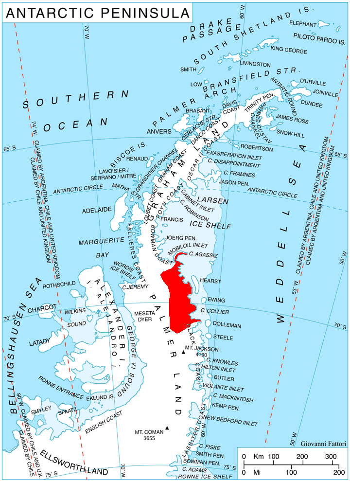
Stefansson Strait () is an ice-filled strait 35 nmi long and 3 to wide, between the east coast of Palmer Land and Hearst Island, Antarctica.
Location
Stefansson Strait is on the Wilkins Coast of Palmer Land, beside the Weddell Sea to the east. It is east of the Eternity Range, north of Hughes Ice Piedmont and south of Scripps Heights and Casey Inlet. The strait separates Hearst Island from the mainland. The south of the strait is at the north side of the mouth of Anthony Glacier, which flows eastward past the Engel Peaks and Mount Martin to enter the sea north of Lewis Point. Features of the coast to the west of the strait, from south to north, include Rhino Rock, Cape Rymill, Briesemeister Peak and Cape Reichelderfer. The Binghy Glacier flows east between De Busk Scarp and Le Feuvre Scarp to enter the trait north of Cape Reichelderfer. Lurabee Glacier flow northeast along the southeast side of Scripps Heights to enter the sea just north of the strait between Cape Walcott and Cape Hinks on Finley Heights.
Discovery and name
Stefansson Strait was first sighted by Sir Hubert Wilkins at the south end of his flight of December 20, 1928, and was named by him for Vilhjalmur Stefansson. He believed it to be a strait cutting off what is now known to be Antarctic Peninsula from the main land mass of Antarctica. The true orientation of the strait was determined by members of the United States Antarctic Service (USAS) who charted this coast by land and from the air in 1940.
Features

Hearst Island
Anthony Glacier
Engel Peaks
Mount Martin
Rhino Rock
Cape Rymill
Briesemeister Peak
Cape Reichelderfer
Lurabee Glacier
Cape Hinks
Finley Heights
References
Sources
- {{citation|url=https://pubs.usgs.gov/fedgov/70039167/report.pdf |accessdate=2023-12-03 |edition=2 |editor-last=Alberts |title=Geographic Names of the Antarctic |editor-first=Fred G.
- {{citation |url=https://commons.wikimedia.org/wiki/File:Palmer_Land_North_USGS_Sketch.jpg |accessdate=2024-04-25
This article was imported from Wikipedia and is available under the Creative Commons Attribution-ShareAlike 4.0 License. Content has been adapted to SurfDoc format. Original contributors can be found on the article history page.
Ask Mako anything about Stefansson Strait — get instant answers, deeper analysis, and related topics.
Research with MakoFree with your Surf account
Create a free account to save articles, ask Mako questions, and organize your research.
Sign up freeThis content may have been generated or modified by AI. CloudSurf Software LLC is not responsible for the accuracy, completeness, or reliability of AI-generated content. Always verify important information from primary sources.
Report