From Surf Wiki (app.surf) — the open knowledge base
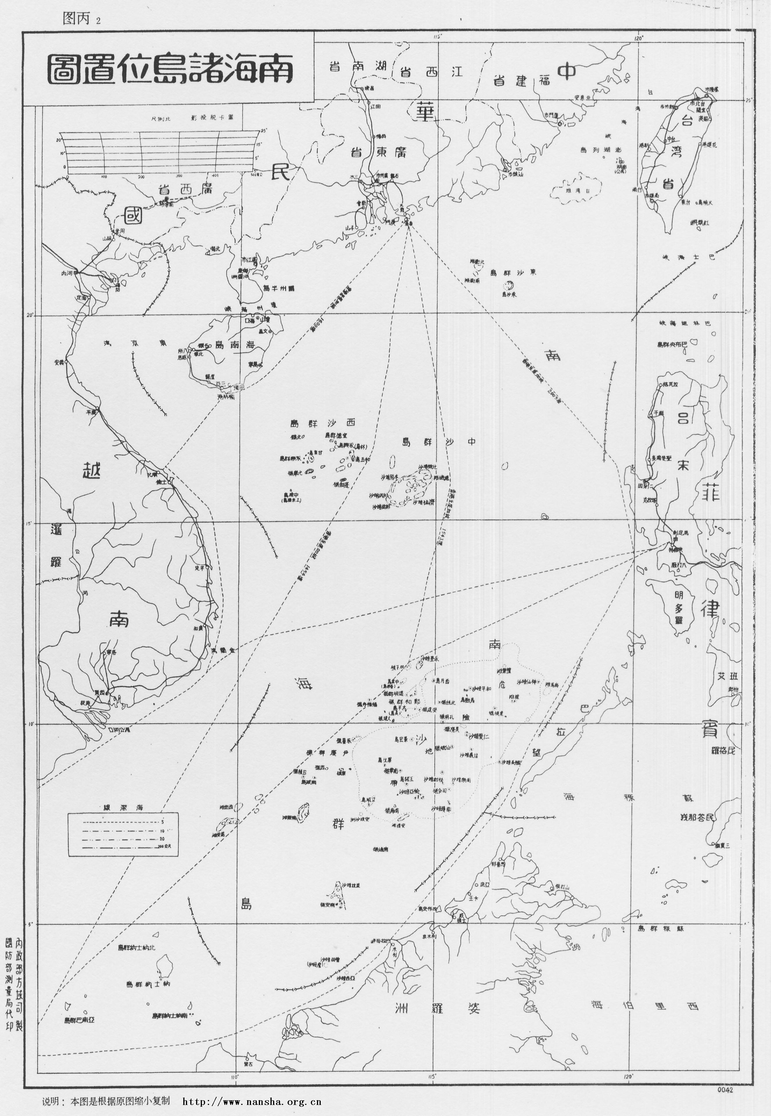
Spratly Islands dispute
Territorial dispute involving multiple countries over the Spratly Islands
Territorial dispute involving multiple countries over the Spratly Islands
The Spratly Islands dispute is an ongoing territorial dispute among Brunei, China (PRC), Malaysia, the Philippines, Taiwan (ROC), and Vietnam concerning "ownership" of the Spratly Islands, a group of islands and associated "maritime features" (reefs, banks, and cays etc.) located in the South China Sea. The dispute is characterized by diplomatic stalemate and the employment of military pressure techniques (such as military occupation of disputed territory) in the advancement of national territorial claims. All except Brunei occupy some of the maritime features.
Most of the "maritime features" in this area have at least six names: The "international name", usually in English; the "Chinese name", sometimes different for PRC and ROC (and also in different character-sets); the Philippine, Vietnamese and Malaysian names, and also, there are alternate names (e.g. Spratly Island is also known as Storm Island), and sometimes names with European origins (French, Portuguese, Spanish, British, etc.).
Although not large, reserves of oil and natural gas have been found in the area. It is a commercial fishing ground and close to global shipping routes. Its strategic position allows countries to monitor maritime activities in the area and project military power. The United Nations Convention on the Law of the Sea (UNCLOS) does not decide on the sovereignty of disputed territories, as that requires separate legal and diplomatic efforts beyond the scope of UNCLOS. Additionally, China (PRC), Taiwan (ROC), and Vietnam are the only ones to have made claims based on historical sovereignty of the islands.
Background information
Hydrocarbons
In 1968, oil was discovered in the region. On 11 March 1976, the first major Philippine oil discovery occurred off the coast of Palawan, near the Spratly Islands territory. In 2010, these oil fields supplied 15% of all petroleum consumed in the Philippines. In 1992, the PRC and Vietnam granted oil exploration contracts to US oil companies that covered overlapping areas in the Spratlys. In May 1992, the China National Offshore Oil Corporation (CNOOC) and Crestone Energy (a US company based in Denver, Colorado) signed a co-operation contract for the joint exploration of the Wan'an Bei-21 block, a 25155 km2 section of the southwestern South China Sea that includes Spratly Island areas.
In 2012–2013, the United States Energy Information Administration estimates very little oil and natural gas in contested areas such as the Paracels and the Spratly Islands. Most of the proved or probable 11 billion barrels of oil and 190 trillion cubic feet of natural gas in the South China Sea exist near undisputed shorelines.
Commercial fishing
In 2010, the Western Central Pacific (excluding the northernmost reaches of the South China Sea closest to the PRC coast) accounted for 14% of the total world catch at 11.7 million tonnes. This was up from less than 4 million tonnes in 1970. In 1984, Brunei established an exclusive fishing zone encompassing Louisa Reef in the southeastern Spratly Islands. (Archived from the original on 2005-01-07).
Additionally, pages 48 and 51 of "The Brunei-Malaysia Dispute over Territorial and Maritime Claims in International Law" by R. Haller-Trost, Clive Schofield, and Martin Pratt, published by the International Boundaries Research Unit , University of Durham, UK, points out that this is a "territorial dispute" between Brunei and other claimants over the ownership of one above-water feature – Louisa Reef.
Global shipping
The area is close to some of the busiest shipping lanes in the world, accounting for $3.4 trillion of the $16 trillion global trade in 2016.
Presence by country
Claims and their basis


China, the Philippines, Taiwan (ROC) and Vietnam claim the whole Spratly Islands while Brunei and Malaysia claim part of the Islands.
Brunei
Brunei claims the part of the South China Sea nearest to it as part of its continental shelf and exclusive economic zone (EEZ). In 1984, Brunei declared an EEZ encompassing the above-water islets it claims in Louisa Reef. Brunei does not practice military control in the area.
Basis of Brunei's claim
Brunei's claims to the reef are based on the United Nations Convention on the Law of the Sea (UNCLOS). Brunei states that the southern part of the Spratly Islands chain is actually a part of its continental shelf, and therefore a part of its territory and resources.
The People's Republic of China (China) and the Republic of China (Taiwan)
The People's Republic of China (PRC) claims are based on history and not UNCLOS. However, the PRC still claims all of the Spratly Islands as part of China. The PRC is a party to the UNCLOS, signing the agreement on 29 July 1994.
The Republic of China (ROC), which ruled Mainland China before 1949 and has been confined to Taiwan since 1949, also claims all of the Spratly Islands.
Basis for the PRC's and the ROC's claims
Chinese (Qin dynasty) fishermen may have fished around the islands since 200 BC, although activity dates to before recorded history, thousands of years ago along with neighboring Nusantaria (present-day Philippines, Indonesia, Malaysia, Brunei, Taiwan, and East Timor). China's discovery claims to date back to the Han dynasty in 2 BC. The islands are claimed to have been marked on maps compiled during the Eastern Han dynasty and Eastern Wu (one of the Three Kingdoms). In the Yuan dynasty (12th century), several islands that may be the Spratlys were labelled as Chinese territory according to the Yuanshi, an official history commissioned by the Hongwu Emperor of the Ming dynasty in 1369. Similar labeling also occurred in the Qing dynasty (13th to 19th century); the islands may have appeared on a 1755 map, among others. French divers found remains of a 15th-century Chinese galleon near the coast of Brunei, cited by Beijing as proof that 15th-century Chinese sailed these waters.
In the 19th century, Europeans found that Chinese fishermen from Hainan annually sojourned to the Spratly Islands for part of the year, similar to neighboring Austronesians for thousands of years. In 1877 the British launched the first modern legal claims to the Spratlys.
When it was discovered that the area was being surveyed by Germany in 1883, China issued protests against them. China sent naval forces on inspection tours in 1902 and 1907 of the Paracel Islands and placed flags and markers on the islands. In 1909 it established a naval presence for a time in the Paracels as a reaction to Japanese moves. The Qing dynasty's successor state, the Republic of China, was to later claim the Spratly and Paracel Islands under the jurisdiction of Hainan.
The Spratlys and the Paracels were conquered from France by Japan in 1939. Japan administered the Spratlys via Taiwan's jurisdiction and the Paracels via Hainan's jurisdiction. Upon its surrender in 1945, Japan handed the Paracels and Spratlys to Republic of China as the Allied powers had assigned the Republic of China to receive Japanese surrenders in that area.
After World War II ended, the Republic of China was the "most active claimant". The Republic of China then garrisoned Itu Aba (Taiping) Island in 1946 and posted Chinese flags and markers on it along with Woody island in the Paracels, France tried, but failed to make them leave Woody island. The aim of the Republic of China was to block the French claims. The Republic of China drew up the map showing the U-shaped claim on the entire South China Sea including the Spratly and Paracels in 1947.
Taiwan's garrison from 1946 to 1950 and 1956–present on Itu Aba represents an "effective occupation" of the Spratly Islands.
On May 15, 1996, the PRC submitted to the United Nations its geographic baseline, which included the Paracel Islands and Senkaku/Diaoyu Islands, but did not include the Spratly Islands.
China and Taiwan rejected a 2016 UNCLOS arbitration that found no support for their historical titles to the maritime areas and resources within the nine-dash line, without making determinations regarding the sovereignty of the terrestrial islands there.
Malaysia
Malaysia claims a small number of islands in the Spratly Islands and its claims cover only the islands included in its exclusive economic zone of 200 miles as defined by the United Nations Convention on the Law of the Sea. Malaysia has militarily occupied five islands that it considers to be within its continental shelf. Swallow Reef (Layang Layang / Terumbu Layang / Pulau Layang Layang) was under control in 1983 and has been turned into an island through a land reclamation which now also hosts a dive resort. The Malaysian military also occupies Ardasier Reef (Terumbu Ubi), and Mariveles Reef (Terumbu Mantanani).
Basis of Malaysia's claim
Malaysia's claims are based upon the continental shelf principle, and have clearly defined coordinates within the limits of its EEZ defined in 1979. This argument requires that the islands were res nullius and this requirement is said to be satisfied as when Japan renounced their sovereignty over the islands according to the San Francisco Treaty, there was a relinquishment of the right to the islands without any special beneficiary. Therefore, the islands became res nullius and available for annexation.
The Philippines
Main article: Philippines and the Spratly Islands
The Republic of the Philippines claims the Spratly islands and are based on sovereignty over the Spratly Islands on the issues of res nullius and geography.
Basis for the Philippine claim
When the Philippines gained independence in 1946, the Philippine nationalists wanted to claim the Spratly Islands. The American advisors, however, discouraged them due to the fact that the Spanish-American Treaty of 1898 clearly stipulated that the western limit of the Philippine islands did not include the Spratlys. The Americans did not want to bring conflict with the Chiang Kai-shek regime in China.
The Philippines contend their claim was res nullius as there was no effective sovereignty over the islands until the 1930s when France and then Japan acquired the islands. When Japan renounced their sovereignty over the islands according to the San Francisco Treaty, there was a relinquishment of the right to the islands without any special beneficiary. Therefore, the islands became res nullius and available for annexation, according to the claim.
In 1956, a private Filipino citizen, Tomás Cloma, unilaterally declared a state on 53 features in the South China Sea, calling it "Freedomland". In December 1974, Cloma was arrested and forced to sign a document to convey to the Philippines whatever rights he might have had in the territory for one peso. Cloma sold his claim to the Philippine government, which annexed (de jure) the islands in 1978, calling them Kalayaan. On 11 June 1978, President Ferdinand Marcos of the Philippines issued Presidential decree No. 1596, declaring the Spratly Islands (referred to therein as the Kalayaan Island Group) as Philippine territory.

The Philippine claim to Kalayaan on a geographical basis can be summarised using the assertion that Kalayaan is distinct from other island groups in the South China Sea, because of the size of the biggest island in the Kalayaan group. A second argument used by the Philippines regarding their geographical claim over the Spratlys is that all the islands claimed by the Philippines lie within its 200-mile exclusive economic zone according to the 1982 United Nations Convention on the Law of the Sea. This argument assumes that the islands were res nullius. The Republic of the Philippines also contend, under maritime law that the People's Republic of China can not extend its baseline claims to the Spratlys because the PRC is not an archipelagic state.
Vietnam
On 25 July 1994, Vietnam ratified the UNCLOS. Upon ratification it declared: Vietnam's response to China's claim is that Chinese records on Qianli Changsha and Wanli Shitang are records about non-Chinese territories. For example, Qianli Changsha and Wanli Shitang were referred to in the ancient Chinese texts Ling Wai Dai Da and Zhu Fan Zhi as being in the Sea of Jiaozhi, Jiaozhi being the old name for a Chinese province in modern-day northern Vietnam, or as writings on foreign countries.
Vietnam's view is that the Chinese records do not constitute the declaration and exercise of sovereignty and that China did not declare sovereignty over the Spratlys until after World War II.
Basis of Vietnam's claim
Vietnam claims the Spratlys based on international law on declaring and exercising sovereignty.
Vietnam claims that it has occupied the Spratly and the Paracel islands at least since the 17th century, when they were not under the sovereignty of any state, and that they exercised sovereignty over the two archipelagos continuously and peacefully until they were invaded by Chinese armed forces. In Phủ biên tạp lục (撫邊雜錄, Miscellaneous Records of Pacification in the Border Area) by the scholar Lê Quý Đôn, Hoàng Sa (Paracel Islands), and Trường Sa (Spratly Islands) were defined as belonging to Quảng Ngãi District. In Đại Nam nhất thống toàn đồ (大南ー統全圖), an atlas of Vietnam completed in 1838, Trường Sa was shown as Vietnamese territory. Vietnam had conducted many geographical and resource surveys of the islands. The results of these surveys have been recorded in Vietnamese literature and history published since the 17th century. After the treaty signed with the Nguyễn dynasty, France represented Vietnam in international affairs and exercised sovereignty over the islands.
The Cairo Declaration, drafted by the Allies and China towards the end of World War II, listed the territories that the Allies intended to strip from Japan and return to China. Despite China being among the authors of the declaration, this list did not include the Spratlys. Vietnam's response to China's claim that the Cairo Declaration somehow recognised the latter's sovereignty over the Spratlys is that it has no basis in fact.
At the San Francisco Conference on the peace treaty with Japan, the Soviet Union proposed that the Paracels and Spratlys be recognised as belonging to China. This proposal was rejected by an overwhelming majority of the delegates. On 7 July 1951, Tran Van Huu, head of the Bảo Đại Government's (State of Vietnam) delegation to the conference declared that the Paracels and Spratlys were part of Vietnamese territory. This declaration met with no challenge from the 51 representatives at the conference. North Vietnam, however, supported China's authority. The final text of the Treaty of San Francisco did not name any recipient of the Spratlys.
The Geneva Accords, which China was a signatory, settled the First Indochina War end. French Indochina was split into three countries: Laos, Cambodia and Vietnam. Vietnam was to be temporarily divided along the 17th Parallel.
Chapter I, Article 4 states: On 26 October 1955, the Republic of Vietnam "South Vietnam" replaced the State of Vietnam (part of the French Union) and inherit of its rights. The Vietnamese government's Vietnam United Youth League, which runs the newspaper Thanh Niên News, claims that although, nothing was said explicitly about offshore archipelagos, which was of small interest by that times, it was clearly understood by all the parties that the Republic of Vietnam inherit of all the French Indochina's Vietnamese territories under the 17th Parallel. As the Paracel and the Spratly archipelagos (which lay below the 17th parallel) were part of the French Indochina since 1933, they were part of "South Vietnam" territory. The French bestowed its titles, rights, and claims over the two island chains to the Republic of Vietnam.
The Republic of Vietnam (RVN) exercised sovereignty over the islands, by placing border markers on the Spratlys to indicate South Vietnamese sovereignty over the archipelago. Up to the end of the Vietnam War the Republic of Vietnam Navy held military control over the majority of the Spratly Islands until 1975, when North Vietnamese troops attacked South Vietnamese troops and occupied the islands. After the Vietnam War, the unified Vietnam SRV (Socialist Republic of Vietnam) continued to claim the Spratly islands as an indisputably integral part of Vietnam.
The islands occupied by Vietnam are organised as a district of Khánh Hòa Province. According to the 2009 census, the Trường Sa District has a population of 195 people. At the 12th National Assembly (2007–2011) Election held early in Trường Sa, the people and soldiers also voted for their local district government for the first time. For the first time, Trường Sa is organised like a normal inland district, with a township (Trường Sa) and two communes (Sinh Tồn and Song Tử Tây). Forty nine people were elected to the communes' people's councils. In July 2012 the National Assembly of Vietnam passed a law demarcating Vietnamese sea borders to include the Spratly and Paracel Islands.
Champa historically had a large presence in the South China Sea. The Vietnamese broke Champa's power in an invasion of Champa in 1471, and then finally conquered the last remnants of the Cham people in a war in 1832. The Vietnamese government fears that using the evidence of Champa's historical connection to the disputed islands in the South China Sea would expose the human rights violations and killings of ethnic minorities in Vietnam such as in the 2001 and 2004 uprisings, and lead to the issue of Cham autonomy being brought to attention.
2014 China-Vietnam oil rig crisis and controversy over Phạm Văn Đồng's 1958 letter
During the Hai Yang Shi You 981 standoff, also known as the 2014 China-Vietnam oil rig crisis near the Paracel Islands China has produced a letter written by North Vietnam's former prime minister Phạm Văn Đồng in 1958 as proof that it holds sovereignty over the Paracel and Spratly islands. The Vietnamese newspaper Thanh Niên News claims China has intentionally misrepresented the letter, which contains no direct reference to either island chain. In addition, they claim that China is ignoring the spirit and time in which the letter was written. During that time, the two communist neighbours shared extremely close ties and the US navy was patrolling the Taiwan Strait, threatening them both. The letter, according to the newspaper, represented a diplomatic gesture of goodwill that has no legal relevance to the current territorial dispute.
On 4 September 1958, with the seventh fleet of the US Navy patrolling the Taiwan Strait, China announced its decision to extend the breadth of its territorial waters to 12 nautical miles. The United Nations (to which China was not yet a member) had just held its first Conference on the Law of the Sea in Switzerland in 1956, and the resulting treaties, including the Convention on the Territorial Sea and the Contiguous Zone, were signed in 1958. Though the UN conference was considered a success, it left the exact breadth of each nation's territorial waters somewhat unresolved; the US, for instance, said it should extend just three nautical miles.
On 14 September 1958, North Vietnam's PM Phạm Văn Đồng wrote a letter to PM Zhou Enlai in response to China's declaration.
| Original | English |
|---|---|
| Thưa Đồng chí Tổng lý, | Dear Comrade Prime Minister, |
The Vietnamese newspaper Thanh Nien News claims that the letter has no legal relevance in China's sovereignty claims to the Paracel and Spratly archipelagos for the three following reasons:
- Point 1: The Democratic Republic of Vietnam (North Vietnam) was not in control of the Paracel and the Spratly archipelagos at the time PM Dong wrote his letter.
- Point 2: The Constitutions of 1946 and 1957 of the Democratic Republic of Vietnam stipulated that territorial transfers must be decided by an act of parliament, the most powerful body in the country. As such, the prime minister had no right to relinquish the islands.
- Point 3: PM Phạm Văn Đồng's letter is a unilateral declaration written solely as a response to China's declaration on a 12 nautical mile territorial waters. The letter makes no mention, whatsoever, of territorial sovereignty over any archipelago.
International law

Doctrine of intertemporal law
The doctrine of intertemporal law was established after the Island of Palmas Case ruling. Under the doctrine, treaty rights are assessed under the laws in force at the time the treaty is made, not at the time a dispute takes place.
Law on inhabited vs uninhabited territories
International law on claims differ if the territory is inhabited or uninhabited. In the 1928 Island of Palmas case, for inhabited territories, the court stated that "although continuous in principle, sovereignty cannot be exercised in fact at every moment on every point of a territory. The intermittence and discontinuity compatible with the maintenance of the right necessarily differ according as inhabited or inhabited regions are involved, or region enclosed within territories in which sovereignty is incontestably displayed or again regions accessible from, for instance, the high seas." For uninhabited territories, the 1931 Clipperton Island case ruled that "if a territory, by virtue of the fact it was completely uninhabited, is, from the first moment when the occupying state makes its appearance there, at the absolute and undisputed disposition of that state, from the moment the taking of possession must be considered as accomplished, and the occupation is thereby completed. Xxx [T]the fact that [France] has not exercised her authority there in a positive manner does not imply the forfeiture of an acquisition already definitely perfected." The ruling was affirmed in the 1933 Eastern Greenland case.
Critical date doctrine
In the Eastern Greenland Case between Norway and Denmark, the critical date doctrine was established. It was ruled by the Permanent Court of International Justice (PCIJ) that the Norwegian proclamation on July 10, 1931, annexing Eastern Greenland was the "critical date" in that specific case.
Uti possidetis juris
Under the principle of uti possidetis juris, the boundaries of former colonies must be respected by all states. It was established after the Frontier Dispute case between Burkina Faso and Mali. The ICJ ruled that uti possidetis juris is a "general principle, which is logically connected with the phenomenon of the obtaining of independence, wherever it occurs. Its obvious purpose is to prevent the independence and stability of new States being endangered by fratricidal struggles provoked by the challenging of frontiers following the withdrawal of the administering power…Its purpose, at the time of the achievement of independence by the former Spanish colonies of America, was to scotch any designs which non-American colonizing powers might have on regions which had been assigned by the former metropolitan State to one division or another, but which were still uninhabited or unexplored."
Maps in international law claims
Maps cannot establish title to territory unless it is attached to a treaty. Moreover, maps unilaterally produced by a state, even if not attached to a treaty, can bind the producing state if it is "adverse to its interest". This was established in the 2002 Delimitation of the Border between the State of Eritrea and Ethiopia case, and was affirmed further in the Pedra Blanca arbitration between Malaysia and Singapore in 2008, when the ICJ ruled: "The map still stands as a statement of geographical fact, especially when the State adversely affected has itself produced and disseminated it, even against its own interest."
Extended continental shelf claims, 2009
Main article: Extended continental shelf
Via UNCLOS, the United Nations provided for countries with coastlines to submit claims to the UN's Commission on the Limits of the Continental Shelf (CLCS) for their continental shelf to be extended beyond 200 nautical miles of their shores. By 13 May 2009, a total of 48 nations made full claims, and dozens more made preliminary submissions. Two of the submissions made to the CLCS addressed claims in the South China Sea (SCS) – one by Vietnam for a claim over the northern portion of the SCS (which included the Paracel Islands), and another jointly by Vietnam and Malaysia for a joint claim over a "defined area" in the middle of the SCS between the two countries, which included part of the Spratly Islands. Brunei made a preliminary submission notifying of its intention to claim a continental shelf beyond 200 nautical miles from its shores.
China (PRC) immediately issued protests over the two submissions and called on the United Nations not to consider them. It also issued a stern warning to countries not to claim the islands which it said were its sovereign territory.
Philippine protests to ITLOS, 2011
On 23 May 2011, Former Philippine President Benigno Aquino III warned the visiting Chinese defense minister Liang Guanglie of a possible arms race in the region if tensions worsened over disputes in the South China Sea. In March, the Philippines complained that Chinese patrol boats had harassed a Philippine oil exploration vessel in disputed waters near the Spratlys, and subsequently filed a formal protest at the International Tribunal for the Law of the Sea (ITLOS).
Arbitration tribunal, 2013–2016
Diplomacy
1992 ASEAN Declaration on the South China Sea
On 22 July 1992, ASEAN issued a declaration on the South China Sea, emphasising that the dispute should be solved peacefully without resorting to violence.
Declaration on the Conduct of Parties in the South China Sea, 2002
On 4 November 2002 in Phnom Penh, the Declaration on the Conduct of Parties in the South China Sea was signed by the 10 foreign ministers of ASEAN countries and China (PRC). The parties explicitly undertook in this declaration, "to resolve their territorial and jurisdictional disputes by peaceful means, without resorting to the threat or use of force, through friendly consultations and negotiations by sovereign states directly concerned".
Code of Conduct in the South China Sea
In July 2012, China (PRC) announced that it is open to launching discussions on the Code of Conduct in the South China Sea, but called for all parties to exercise self-restraint in keeping with the spirit of previous declarations and United Nation conventions. This announcement has been criticised by many neighbouring states because of the contradictions seen in the Scarborough Shoal at that time where China has established de facto control.
History of the Spratly Islands
From approximately 500 BC to 100 AD, shipping routes of the Sa Huynh-Kalanay trading network traversed the South China Sea. They were used to exchange pottery and jewelry (such as jade) across Taiwan, the Philippines, and Borneo.
In 1734, the Carta Hydrographica y Chorographica de las Islas Filipinas (commonly referred as the Velarde map) was published by the Spanish colonial government. According to Philippine judge Antonio Carpio, the map shows Philippine sovereignty over the Spratly Islands (referred as Los Bajos de Paragua) and is the earliest map showing sovereignty over the said territories. Philippine officials and writers also assert that the 1808 and 1875 editions of Carita General del Archipelago Filipino, published by the Spanish colonial government, included the Spratly islands as sovereign territory of the Philippines and was recognized by the international community.
In the 19th century, Europeans found that Chinese fishermen from Hainan annually sojourned on the Spratly islands for part of the year specifically for trade, which was also common for other ethnic groups in the area such as the Cham of Vietnam and the people of Palawan, Sulu, and Luzon in the Philippines. In 1877, the British laid a claim to two Spratly islands and dispatched an expedition group there after learning of the presence of guano from locals in British-colonized Borneo. However, the group forgot to plant the British flag after the white businesspersons and their Chinese employees attacked one another due to a dispute.
When the Spratlys and Paracels were being surveyed by Germany in 1883, China issued protests against them.
After the Spanish-American War, Spain ceded the territory of the Philippines to the United States through the 1898 Treaty of Paris. The treaty lines drawn were inaccurate, leading to the Spanish to retain sovereign control over the Spratly Islands, Scarborough Shoal, and parts of Tawi-Tawi. According to the Philippine government, this was later rectified retroactively in the 1900 Treaty of Washington where the mentioned remaining territories were formally ceded to the United States and their interpretation is that this was as part of the territory of the Philippines at their independence.
In 1930 a French vessel formally laid claims to an area of the Spratlys without naming any specific island in order to avoid any overlap with the Philippine territory as defined in 1898. The French were unaware of Britain's earlier claim. After a series of internal debates, British officials decided not to push their claims due to disagreements over how important the Spratlys were, a perceived weakness of their claim from not following up on it since 1877, and their wish for France to act as a buffer in the South China Sea against growing threats to the British from Japan.
Between April 7, 1933, and April 13, 1933, France took possession of the Spratly Islands and notification of the occupation appeared in the Official Journal of July 26, 1933. France claimed the Spratlys for the French Union, rather than as part of Indochina (and its successor Vietnam). China protested.
The Spratlys and the Paracels were conquered by Japan in 1939. Japan annexed the Spratly Islands via Taiwanese jurisdiction as part of Kaohsiung on 30 March 1939. France and UK protested and reasserted French sovereignty.
China Handbook 1937–1943: A comprehensive survey of major developments in China in six years of war was published by the Republic of China in 1943 and stated its southernmost territory as "Triton Island of the Paracel Group". China Handbook 1937–1945, a revised edition covering the entire Second Sino-Japanese War, claimed that the Spratly islands were contested among China, the Philippines, and Indochina. The Paracels and Spratlys were handed over to Republic of China control from Japan after the 1945 surrender of Japan, since the Allied powers assigned the Republic of China to receive Japanese surrenders in that area.
The Republic of China garrisoned Itu Aba (Taiping) island in 1946 and posted Chinese flags and markers on it along with Woody island in the Paracels, France tried, but failed to make them leave Woody island. The aim of the Republic of China was to block the French claims.
In 1947, the Republic of China drew up the map showing the U-shaped claim on the entire South China Sea, showing the Spratly and Paracels in Chinese territory. In 1947, the ROC government renamed 159 islands in the area and published the Map of the South China Sea Islands. The ROC has occupied Taiping Island, the largest island in the Spratlys, constantly since 1956.
After pulling out its garrison in 1950 when the Republic of China evacuated to Taiwan, when the Filipino Tomas Cloma uprooted an ROC flag on Itu Aba laid claim to the Spratlys and, the Republic of China (now Taiwan) again regarrisoned Itu Aba in 1956.
Taiwan's garrison from 1946 to 1950 and 1956-now on Itu Aba represents an "effective occupation" of the Spratlys. China established a coastal defence system against Japanese pirates or smugglers. During the San Francisco Peace Conference of 1951, the San Francisco Peace Treaty was signed. During the conference, the USSR motioned for the Paracels and the Spratly to be awarded to China, but the motion was rejected by a vote of 46 to 3, with one abstention.
In 1953, the French Foreign Ministry declared that the Spratlys were "not attached to Vietnam in 1949, when the former colony of Conchinchina was ceded to this Associated State. They (Spratlys) therefore depend on (administered by) the Ministry of Overseas France." In 1955, the French Foreign Ministry prepared another "Note" that "beyond doubt that the Spratlys belonged to the French Union, not Vietnam."
North Vietnam recognised China's claims on the Paracels and Spratlys during the Vietnam War as it was being supported by China. Only after winning the war and conquering South Vietnam did North Vietnam retract its recognition and admitted it recognised them as part of China to receive aid from China in fighting the Americans.
The Philippines claimed the Spratlys in 1971 under President Marcos, after Taiwanese troops attacked and shot at a Philippine fishing boat on Itu Aba.
Under President Lee Teng-hui, Taiwan stated that "legally, historically, geographically, or in reality", all of the South China Sea and Spratly islands were Taiwan's territory and under Taiwanese sovereignty, and denounced actions undertaken there by Malaysia and the Philippines, in a statement on 13 July 1999 released by the foreign ministry of Taiwan. Taiwan and China's claims "mirror" each other; during international talks involving the Spratly islands, China and Taiwan have cooperated with each other since both have the same claims.
Taiwan and China are largely strategically aligned on the Spratly islands issue, since they both claim exactly the same area, so Taiwan's control of Itu Aba (Taiping) island is viewed as an extension of China's claim. Taiwan and China both claim the entire island chain, while all the other claimants only claim portions of them. China has proposed co-operation with Taiwan against all the other countries claiming the islands. Taiwanese lawmakers have demanded that Taiwan fortify Itu Aba (Taiping) island with weapons to defend against the Vietnamese, and both China and Taiwanese NGOs have pressured Taiwan to expand Taiwan's military capabilities on the island, which played a role in Taiwan expanding the island's runway in 2012. China has urged Taiwan to co-operate and offered Taiwan a share in oil and gas resources while shutting out all the other rival claimants. Taiwanese lawmakers have complained about repeated Vietnamese aggression and trespassing on Taiwan's Itu Aba (Taiping), and Taiwan has started viewing Vietnam as an enemy over the Spratly Islands, not China. Taiwan's state run oil company CPC Corp's board director Chiu Yi has called Vietnam as the "greatest threat" to Taiwan. Taiwan's airstrip on Taiping has irritated Vietnam. China views Taiwan's expansion of its military and airstrip on Taiping as benefiting China's position against the other rival claimants from southeast Asian countries.
In 1990, China published the first volume of its "An Atlas of Ancient Maps of China" through the Cultural Relics Publishing House, Beijing, a publishing arm of the State Bureau of Cultural Relics of China. The second volume was published in 1994, while the third and final volume was published in 1997. The ancient maps in all three volumes showed Hainan as the southernmost territory of any of the dynasties of China.
Malaysia has militarily occupied three islands that it considers to be within its continental shelf. Swallow Reef (Layang Layang / Terumbu Layang / Pulau Layang Layang) was under control in 1983 and has been turned into an island through a land reclamation which now also hosts a dive resort. The Malaysian military also occupies Ardasier Reef (Terumbu Ubi), and Mariveles Reef (Terumbu Mantanani).
Since 1992, Malaysia and Vietnam have agreed to jointly develop areas around these disputed islands. Malaysia has said that it is monitoring all of the actions made by countries involved in the dispute.
Taiwan performed live fire military exercises on Taiping island in September 2012; reports said that Vietnam was explicitly named by the Taiwanese military as the "imaginary enemy" in the drill. Vietnam protested against the exercises as violation of its territory and "voiced anger", demanding that Taiwan stop the drill. Among the inspectors of the live fire drill were Taiwanese national legislators, adding to the tensions.
In 2010, it was reported that the former Malaysian prime minister Mahathir Mohamad believed Malaysia could profit from China's economic growth through co-operation with China, and said that China "was not a threat to anyone and was not worried about aggression from China", as well accusing the United States of provoking China and trying to turn China's neighbours against China. Malaysian authorities displayed no concern over China conducting a military exercise at James Shoal in March 2013,*
- However, until present Malaysia still maintained a balance relations with the countries involved in this dispute. But since China has start encroaching its territorial waters, Malaysia has become active in condemning China.
In 2014 Janes reported that during 2013–2014 China had begun dredging and land reclamation at three sites in the Spratlys. In contrast to the construction projections of other countries, Beijing's efforts involved reefs that for the most part were under water at high tide. Harry Harris, Pacific fleet commander of the U.S. Navy, unofficially described the project as "Great Wall of Sand" in March 2015.
In April 2015, satellite images showed that China was constructing an airfield at Fiery Cross Reef. By September, it had completed a 3125-metre runway.
Notable confrontations
- Southwest Cay Invasion (1975)
- East Sea Campaign (April 1975)
- Johnson South Reef Skirmish (14 March 1988)
- Scarborough Shoal standoff (commenced on 8 April 2012)
- Hai Yang Shi You 981 standoff (2014)
Timeline of other events
| 2024 | last1=Laqui | first1=Ian | date=June 20, 2024 | title=Philippines faces 'barbaric' knife, axe wielding Chinese sailors in WPS | url=https://www.philstar.com/headlines/2024/06/20/2364261/philippines-faces-barbaric-knife-axe-wielding-chinese-sailors-wps | publisher=The Philippine Star | access-date=21 June 2024 | archive-date=21 June 2024 | archive-url=https://web.archive.org/web/20240621041149/https://www.philstar.com/headlines/2024/06/20/2364261/philippines-faces-barbaric-knife-axe-wielding-chinese-sailors-wps | url-status=live }} |
|---|
References
References
- rpazos@st. (29 February 2016). "Before and after satellite images: What has been built on disputed islands in the West Philippine sea".
- [http://www.janes.com/article/39716/china-goes-all-out-with-major-island-building-project-in-spratlys China goes all out with major island-building project in Spratlys – IHS Jane's 360] {{Webarchive. link. (3 November 2014. Janes.com (20 June 2014). Retrieved 12 May 2015.)
- Ho, Andrea. (2021-05-06). "Professor Robert Beckman on the Role of UNCLOS in Maritime Disputes".
- Bowring, Philip. (6 May 1994). "China Is Getting Help in a Grab at the Sea". The New York Times.
- (7 February 2013). "South China Sea". US Energy Information Administration (eia).
- TED (Trade and Environment Database), Mandala Project. (December 1997). "Spratly Islands Dispute". American University.
- Lai To, Lei. (1999). "Chian and the South China Sea dialogues". Praeger Publishers.
- Kate, Daniel. (27 May 2011). "South China Sea Oil Rush Risks Clashes as U.S. Emboldens Vietnam on Claim". Bloomberg News.
- "Contested areas of South China Sea likely have few conventional oil and gas resources – Today in Energy – U.S. Energy Information Administration (EIA)".
- (5 April 2013). "All those oil and gas deposits everyone wants in the South China Sea may not even be there".
- (2012). "World review of fisheries and aquaculture". Food and Agriculture Organisation.
- (2 August 2017). "How Much Trade Transits the South China Sea?".
- [https://www.un.org/Depts/los/index.htm Oceans & Law of the Sea] {{Webarchive. link. (25 June 2017, United Nations)
- (22 August 2013). "Overview". United Nations.
- [https://web.archive.org/web/20120722052731/http://www1.american.edu/ted/SPRATLY.HTM Spratly Island Dispute (SPRATLY Case)], 30 April 1996, Trade Environment Database (TED), American University. (Archived from [http://www.american.edu/TED/SPRATLY.htm the original] {{Webarchive. link. (14 August 2010 on 22 July 2012))
- (2013). "The UN Convention on the Law of the Sea and the Maritime Disputes in the South China Sea". American Society of International Law.
- (1999). "Dictionary of Contemporary Chinese Military History". ABC-CLIO.
- (2 July 2019). "Identity History: Austronesian Asia?". Yale University.
- "《元史》地理志;《元代疆域图叙》".
- "《海南卫指挥佥事柴公墓志铬》".
- "《清直省分图》天下总舆图".
- "《大清一统天下全图》".
- [https://news.bbc.co.uk/2/hi/asia-pacific/331763.stm Undersea Treasure Chest Stirs up Tensions], BBC, 29 April 1999.
- (19 Aug 2014). "Reconstructing Austronesian population history in Island Southeast Asia". Nature Communications.
- (Apr 2019). "The dispersal of Austronesian languages in Island South East Asia: Current findings and debates". Language and Linguistics Compass.
- (2002). "War Or Peace in the South China Sea?". NIAS Press.
- (2008). "Security and International Politics in the South China Sea: Towards a co-operative management regime". Taylor & Francis.
- Bonnet, Francois-Xavier. (November 2012). "Geopolitics of Scarborough Shoal". Institut de Recherche sur l'Asie du Sud-Est Contemporaine – Research Institute on Contemporary Southeast Asia}}{{rp.
- Severino, Rodolfo. (2011). "Where in the World is the Philippines?: Debating Its National Territory". Institute of Southeast Asian Studies.
- [[Claudius Madrolle]]. (1939). "La question de Hai-nan et des Paracels". Politique étrangère.
- (1997). "Vietnam Joins the World". M.E. Sharpe.
- "Spratly Islands".
- Pak, Hŭi-gwŏn. (2000). "The Law of the Sea and Northeast Asia: A Challenge for Cooperation". Martinus Nijhoff Publishers.
- Lin, Cheng-yi. (22 February 2008). "Buffer benefits in Spratly initiative". Asia Times Online.
- (26 April 2021). "Baselines of the Territorial Sea of the People's Republic of China that claimed in 1996".
- "Declaration of the Government of the Peoples Republic of China on the Baseline of the Territorial Sea of the People's Republic of China".
- "Submission with the Compliance of the Deposit Obligations Pursuant to the UNCLOS".
- (7 December 2016). "Eleventh Press Release 12072016 (English)". Permanent Court of Arbitration.
- (12 July 2016). "Beijing rejects tribunal's ruling in South China Sea case". The Guardian.
- Zannia, Neyla. (14 July 2016). "Taiwan rejects ruling on South China Sea with Taiping Island defined as 'rocks'". The Online Citizen.
- "Malaysia Archives".
- Ooi, Keat Gin. (2004). "Southeast Asia: A Historical Encyclopedia, from Angkor Wat to East Timor". ABC-CLIO.
- Chia Lin Sien. (2003). "Southeast Asia Transformed: A Geography of Change". Institute of Southeast Asian Studies.
- Furtado, Xavier. (December 1999). "International Law and the Dispute over the Spratly Islands: Whither UNCLOS?". Contemporary Southeast Asia.
- Womack, Brantly. (2006). "China and Vietnam". Cambridge University Press.
- (11 June 1978). "Presidential Decree No. 1596 – Declaring certain area part of the Philippine Territory and providing for their government and Administration". Chan Robles Law Library.
- (25 July 1994). "UNCLOS. Declarations upon ratification: Viet Nam". United Nations.
- Luu Van Loi. (1996). "The Sino-Vietnamese difference on the Hoang Sa and Truong Sa archipelagos". The Gioi publisher.
- Ling Wai Dai Da (Information on Things Beyond the Passes) by Zhou Choufei
- Zhu Fan Zhi (Notes on Foreign Countries) by Zhao Juguo
- (1996). "The Spratly Islands dispute: who's on first?". IBRU.
- (March 2014). "The Vietnamese state's long standing and uninterrupted sovereignty over the Hoang Sa and Truong Sa archipelagoes". Authority of Foreign Information Service (Vietnam)}} {{dead link.
- (1 December 1943). "Cairo Communiquè, December 1, 1943". Japan National Diet Library.
- Ma, Xuechan. (2021-11-20). "Introduction". Brill Nijhoff.
- [http://www.taiwandocuments.org/sanfrancisco01.htm San Francisco Peace Treaty] {{Webarchive. link. (21 February 2001. Taiwandocuments.org. Retrieved 12 May 2015.)
- "Agreement on the Cessation of Hostilities in Vietnam". Office of the Historian, Bureau of Public Affairs, United States Department of State.
- Thao Vi. (2 June 2014). "Late Vietnam PM's letter gives no legal basis to China's island claim". Thanh Nien News.
- "The 2009 Vietnam Population and Housing census: Completed results". General Statistics Office of Vietnam.
- [http://www.smh.com.au/world/china-gets-tough-as-vietnam-claims-disputed-islands-20120622-20th6.html China gets tough as Vietnam claims disputed islands] {{Webarchive. link. (26 June 2012 , Sydney Morning Herald, 23 June 2012 (archived from [http://www.smh.com.au/world/china-gets-tough-as-vietnam-claims-disputed-islands-20120622-20th6.html the original] on 22 June 2012).)
- Perlez, Jane. (21 June 2012). "China Criticizes Vietnam in Dispute Over Islands – Pittsburgh Post-Gazette". Pittsburgh Post-Gazette.
- Ian Glover. (2014). "Southeast Asia: From Prehistory to History". Psychology Press.
- Bray, Adam. (16 June 2014). "The Cham: Descendants of Ancient Rulers of South China Sea Watch Maritime Dispute From Sidelines". National Geographic.
- Wu Yuanfu. (18 June 2014). "Vietnam must honor Pham's note". China Daily.
- Island of Palmas Case, p. 845, Report of International Arbitral Awards, United Nations (2006)
- The Evolutionary Interpretation of Treaties, Eirik Bjorgee, Oxford, p. 142 (2014)
- Island of Palmas Case, p. 840, Report of International Arbitral Awards, United Nations (2006)
- Arbitral Award on the Subject of the Difference Relative to the Sovereignty over Clipperton Island, American Journal of International Law 26, No. 2 (April 1931); 390.
- Legal Status of Eastern Greenland (Norway v. Denmark), Permanent Court of International Justice, 1933, pp. 51-52, PCIJ Series A/B. 53
- Legal Status of Eastern Greenland (Norway v. Denmark), Permanent Court of International Justice, 1933, PCIJ Series A/B. No. 53
- "uti possidetis juris".
- Case Concerning Sovereignty over Pedra Blanca/Pulau Batu Puteh, Middle Rocks and South Ledge, Malaysia v.Singapore, ICJ, May 23, 2008.
- [https://www.un.org/Depts/los/clcs_new/clcs_home.htm Commission on the Limits of the Continental Shelf] {{Webarchive. link. (20 June 2017 (CLCS), United Nations)
- (13 May 2009). "China asserts sea border claims". [[BBC]].
- Refer to the [https://www.un.org/Depts/los/clcs_new/clcs_home.htm CLCS website] {{Webarchive. link. (20 June 2017 for more information on Brunei's preliminary submission.)
- (10 May 2009). "Foreign Ministry Spokesperson Ma Zhaoxu's remarks on Vietnam's Submission on Outer Limits of the Continental Shelf in South China Sea". Ministry of Foreign Affairs, People's Republic of China.
- (24 May 2011). "Philippines warns of arms race in South China Sea". Inquirer Global Nation.
- (22 July 1992). "1992 Asean Declaration on the South China Sea".
- (4 November 2002). "Declaration on the Conduct of Parties in the South China Sea". [[ASEAN.
- (13 July 2012). "China open to discussion on South China Sea code". China Daily.
- Everington, K. (2017). Birthplace of Austronesians is Taiwan, capital was Taitung: Scholar. Taiwan News.
- Bellwood, P., H. Hung, H., Lizuka, Y. (2011). Taiwan Jade in the Philippines: 3,000 Years of Trade and Long-distance Interaction. Semantic Scholar.
- [[Antonio Carpio]]. (May 24, 2024). "Philippine Island Territories in the West Philippine Sea".
- Braid, Florangel Rosario. (February 10, 2024). "'Amplifying the true narrative of the West Philippine Sea'". The Manila Bulletin.
- Layug, Margaret Claire. (11 September 2017). "Murillo Velarde Map refutes 'false history', China's claims – Carpio". [[GMA News]].
- "Panatag is proven PH territory; China claims it by bogus history".
- "'Amplifying the true narrative of the West Philippine Sea'".
- "1875 Carta General del Archipielago Filipino".
- Tonnesson, Stein. (February 2006). "The South China Sea in the Age of European Decline". Modern Asian Studies.
- (1933-07-24). "Journal officiel de la République française. Lois et décrets".
- Tonnesson, Stein. (February 2006). "The South China Sea in the Age of European Decline". Modern Asian Studies.
- China's Claim to the Spratly Islands is Just a Mistake, Bill Hayton, CIMSEC, May 16, 2018
- Ministère de L'Europe et des Affaires étrangères, France Commission de publication des documents relatifs aux origines de la guerre. (1981). "Documents diplomatiques français 1932–1939. 2e série, 1936–1939". Ministère des affaires étrangères, Commission de publication des documents relatifs aux origines de la guerre 1939–1945..
- Ministère de L'Europe et des Affaires étrangères, France Commission de publication des documents relatifs aux origines de la guerre. (1974). "Documents diplomatiques français 1932–1939. 2e série, 1936–1939". Ministère des affaires étrangères, Commission de publication des documents relatifs aux origines de la guerre 1939–1945.
- (1943). "China Handbook 1937-1943 戰時中華志 A Comprehensive Survey of Major Developments in China in Six Years of War". The Macmillan Company.
- (August 2024). "China Handbook 1937–1945, New Edition with 1946 Supplement". Macmillan Co..
- Wiencek, David G.. (2002). "Cooperative monitoring in the South China Sea: satellite imagery, confidence-building measures, and the Spratly Islands disputes". Greenwood Publishing Group.
- {{Harvnb. Morley. Nishihara. 1997
- {{Harvnb. Pak. 2000
- US Department of State Publication, Record of Proceedings of the Conference for the Conclusion and Signature of the Treaty of Peace with Japan, 119, 292 (1951).
- {{Harvnb. Morley. Nishihara. 1997
- STRATFOR. (14 July 1999). "Taiwan sticks to its guns, to U.S. chagrin". Asia Times.
- Sisci, Francesco. (29 June 2010). "US toe-dipping muddies South China Sea". Asia Times Online.
- Kastner, Jens. (10 August 2012). "Taiwan pours cement on maritime dispute". Asia Times Online.
- Kastner, Jens. (13 June 2012). "Taiwan circling South China Sea bait". Asia Times Online.
- Lee, Peter. (29 July 2010). "US goes fishing for trouble". Asia Times Online.
- An Atlas of Ancient Maps in China (1990). Cultural Relics Publishing House, Beijing.
- An Atlas of Ancient Maps in China (1994). Cultural Relics Publishing House, Beijing.
- An Atlas of Ancient Maps in China (1997). Cultural Relics Publishing House, Beijing.
- Sik, Swan. (1994). "Asian Yearbook of International Law: 1992". Martinus Nijhoff Publishers.
- (8 August 2011). "Resolve South China Sea Disputes Diplomatically – Ahmad Zahid". Ministry of Foreign Affairs, Malaysia.
- (27 April 2010). "Mahathir: China no threat to Malaysia". [[The Star (Malaysia).
- Kazuto Tsukamoto. (9 November 2011). "Malaysia's Mahathir says China is no threat". [[The Asahi Shimbun]].
- Shahriman Lockman. (24 April 2013). "Why Malaysia isn't afraid of China (for now)". The Strategist: The Australian Strategic Policy Institute Blog.
- Camille Diola. (25 June 2014). "Why Malaysia, unlike Philippines, keeps quiet on sea row". [[The Philippine Star]].
- (27 September 2015). "Presence of China Coast Guard ship at Luconia Shoals spooks local fishermen". [[The Borneo Post]].
- (15 August 2015). "Malaysia lodges diplomatic protest against intrusion at Beting Patinggi Ali". The Rakyat Post.
- (18 October 2015). "Malaysia slams China's 'provocation' in South China Sea". [[Channel News Asia]].
- (31 March 2015). "Speech delivered to the ''Australian Strategic Policy Institute''". U.S. Navy.
- [http://www.stuff.co.nz/business/world/68466821/Island-building-in-the-South-China-Sea Island building in the South China Sea] {{Webarchive. link. (24 September 2015. Stuff.co.nz. Retrieved 12 May 2015.)
- "China completes runway on Fiery Cross Reef". janes.com.
- (2000). "Sovereignty Over the Paracel and Spratly Islands". Kluwer Law International.
- "International Claims in Spratly and Oil Claims". paracelspratly.com.
- (1991). "China 's Claim of Sovereignty over Spratly and Paracel Islands: A Historical and Legal Perspective".
- Guo, Rongxing. "Territorial Disputes and Resource Management".
- Wang, Frances Yaping. (2024). "The Art of State Persuasion: China's Strategic Use of Media in Interstate Disputes". [[Oxford University Press]].
- Keck, Zachary. (13 March 2014). "Second Thomas Shoal Tensions Intensify". The Diplomat.
- (24 October 2013). "A game of shark and minnow". The New York Times.
- [http://www.gmanews.tv/story/152232/President-Arroyo-signs-baselines-bill-into-law Philippine Baselines Law of 2009 signed] {{Webarchive. link. (18 March 2009, GMA News, 11 March 2009.)
- [https://www.un.org/Depts/los/clcs_new/submissions_files/submission_mysvnm_33_2009.htm Joint submission by Malaysia and the Socialist Republic of Viet Nam] {{Webarchive. link. (8 July 2017. United Nations Commission on the Limits of the Continental Shelf. 28 May 2009. Retrieved 18 September 2009.)
- [https://www.un.org/Depts/los/clcs_new/submissions_files/submission_vnm_37_2009.htm Submission by the Socialist Republic of Viet Nam] {{Webarchive. link. (8 December 2017. United Nations Commission on the Limits of the Continental Shelf. 28 May 2009. Retrieved 18 September 2009.)
- Ian Mansfield (18 May 2011) [http://www.cellular-news.com/story/49219.php China Mobile expands coverage to the Spratly Islands] {{Webarchive. link. (16 March 2012, Cellular News)
- [https://www.theguardian.com/world/2012/jul/13/chinese-frigate-runs-aground-sea Chinese frigate runs aground in disputed part of South China Sea] {{Webarchive. link. (30 March 2017, World news, ''The Guardian''. Retrieved 12 May 2015.)
- (7 May 2014). "Tensions surge in S. China Sea as Philippines seizes Chinese boat". Reuters.
- (20 May 2015). "Exclusive: China warns U.S. surveillance plane". CNN.com.
- (21 May 2015). "Why China's island-building is raising eyebrows".
- "US May Use Military to Confront China in Spratly Island Dispute". Manila Livewire Digital Media Group.
- "Exclusive: China sends surface-to-air missiles to contested island in provocative move". Fox News.
- Mike Ives. (21 June 2017). "China Cancels Military Meeting With Vietnam Over Territorial Dispute". The New York Times.
- Amanda Macias. (2 May 2018). "China quietly installed missile systems on strategic Spratly Islands in hotly contested South China Sea". CNBC.
- (21 Mar 2021). "South China Sea: alarm in Philippines as 200 Chinese vessels gather at disputed reef". The Guardian.
- (November 18, 2021). "Chinese vessels use water cannon to block Philippines vessels from disputed shoal".
- (20 Nov 2022). "China accused of seizing rocket debris from Philippines navy in South China Sea dispute". The Guardian.
- (13 Feb 2023). "Chinese ship accused of using 'military-grade laser' against Philippine vessel". The Guardian.
- "Philippines tells China it will not abandon post in disputed reef".
- (4 April 2024). "Timeline of Chinese Harassment of Second Thomas Shoal Resupply Missions". US Naval Institute.
- (October 22, 2023). "Philippines says a coast guard ship and supply boat were rammed by Chinese vessels at disputed shoal". AP News.
- (June 20, 2024). "Philippines faces 'barbaric' knife, axe wielding Chinese sailors in WPS". [[The Philippine Star]].
This article was imported from Wikipedia and is available under the Creative Commons Attribution-ShareAlike 4.0 License. Content has been adapted to SurfDoc format. Original contributors can be found on the article history page.
Ask Mako anything about Spratly Islands dispute — get instant answers, deeper analysis, and related topics.
Research with MakoFree with your Surf account
Create a free account to save articles, ask Mako questions, and organize your research.
Sign up freeThis content may have been generated or modified by AI. CloudSurf Software LLC is not responsible for the accuracy, completeness, or reliability of AI-generated content. Always verify important information from primary sources.
Report