From Surf Wiki (app.surf) — the open knowledge base
Sierra Nevada de Santa Marta
Mountain range in northern Colombia

Mountain range in northern Colombia
| Field | Value |
|---|---|
| name | Sierra Nevada de Santa Marta |
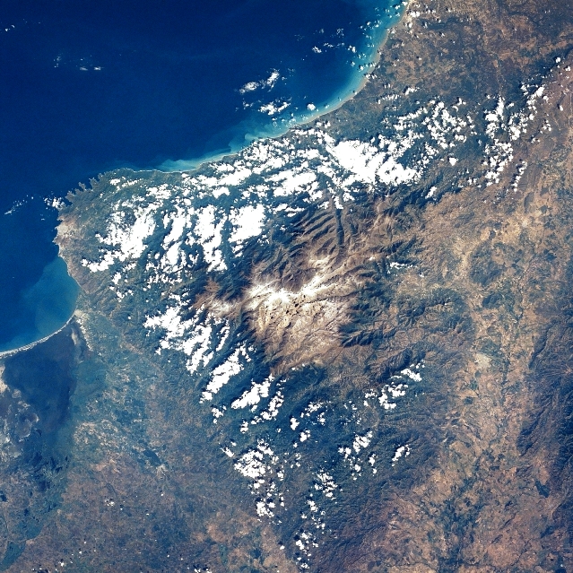
| photo | Amanecer en la Sierra.jpg |
| country | Colombia |
| highest | Pico Simón Bolívar and Pico Cristobal Colon |
| elevation_m | 5710 |
| coordinates | |
| length_km | 162 |
| width_orientation | 29 |
| map | Colombia |
The Sierra Nevada de Santa Marta (English: Snow-Covered Mountain Range of Saint Martha) is an isolated mountain range in northern Colombia, separate from the Andes range that runs through the north of the country. Reaching an elevation of 5700 m just 42 km from the Caribbean coast, the Sierra Nevada is the highest coastal range in the tropics, and one of the highest coastal ranges in the world, being 250. m shorter than the Saint Elias Mountains in Canada. The Sierra Nevada encompasses about 17000 km2 and serves as the source of 36 rivers. The range is in the Departments of Magdalena, Cesar and La Guajira.
The highest point of the Sierra Nevada group (and Colombia in general) may be either Pico Cristóbal Colón or Pico Simón Bolívar, both in the municipalities of Santa Marta and Aracataca; it has yet to be determined which is higher. SRTM data and local topographic maps show that their true elevations are approximately 5700 m, lower than the 5775 m elevation that is often quoted.
The Sierra Nevada is a compact group, relatively small in area, and completely surrounded by lands with elevations below 200 m. Although it is associated with the Tropical Andes, the main backbone of the Andes cannot be reached from the Sierra Nevada without dropping below this level. This makes its highest point the world's fifth most prominent summit.
Several peaks in the Sierra Nevada are intervisible with Cerro Paramillo, a 3730 m peak in Antioquia Department. This implies a theoretical direct line of sight of just over 500 km, reported to be the longest between any two points on the surface of the Earth.
Climate
It is calculated that the yearly average rainfall is 4000. mm at elevations of 500. to. The temperature varies between 0 and.{{Cite web |url-status = dead |archive-url = https://web.archive.org/web/20110722114338/http://www.parquesnacionales.gov.co/PNN/portel/libreria/php/decide.php?patron=01.020224 |archive-date = 2011-07-22
Biodiversity
The tropical rainforest is made up of perennial trees, with a canopy reaching between 30 and. There is a great variety and large populations of epiphytes and lianas, and more than 3,000 species of vascular plants are found in the area.{{Cite web
Of Colombia's 340 endemic species, 44 are found in the park, for example seven species of endemic hummingbirds. Of the 3,057 endangered species, 44 are found here.{{Cite web |access-date = 11 July 2010 |url-status = dead |archive-url = https://web.archive.org/web/20110722114355/http://www.parquesnacionales.gov.co/PNN/portel/libreria/php/decide.php?patron=02.012503 |archive-date = 22 July 2011
The Sierra Nevada de Santa Marta is home to a number of ecoregions, which vary with elevation.
The Guajira–Barranquilla xeric scrub region lies near the Caribbean seacoast to the north of the range. The Sinú Valley dry forests cover the range's lower slopes, up to an elevation of 500. m.
The Santa Marta montane forests lie above 500. to. The montane forests are separated from other moist forests by the lower-elevation dry forests and xeric shrublands, and have large numbers of endemic species. The montane forest ecoregion has several distinct plant communities, distinguished by altitude and rainfall; moist lowland forests cover the windward northern and western flanks of the range between 500. and, and the drier eastern and southern flanks from 1000. to. Above 900. m is a transitional forest zone of smaller trees and palms. Cloud forests occur above 1000. m; the Sub-Andean forests from 1000. to form a canopy 25 to tall, while the higher-elevation Andean forests, between 2500. and, grow to 15 to in height.
The Santa Marta Páramo, a high altitude belt of montane grasslands and shrublands interspersed with marshes and acid bogs, occupies the zone between 3300. and. The Santa Marta Páramo is the northernmost enclave of Páramo in South America, which occur along the Andes belt. Above 5000. m lies the permanent snow cap.
National Natural Park
The Sierra Nevada de Santa Marta National Natural Park () is Colombia's second-oldest national park, established in 1964. It is located in the Cordillera Oriental range, between the departments of La Guajira, Magdalena and Cesar, in the mountain range of the Sierra Nevada de Santa Marta. It is a sanctuary as well as a tourist attraction, because it offers different climate, terrain, flora and fauna environments, ranging from beaches to snowy mountain peaks. Sierra Nevada de Santa Marta National Natural Park is considered a unique place in the world, due to its isolation from the Andes, and its highest peak (5700. m above sea level) is located just 42 km away from the sea.
All the water courses that originate in the national park drain to the Caribbean sea whether directly (e. g. rivers Ranchería, Don Diego, Palomino, Buritaca, Guachaca, Cañas, etc.) or through the Magdalena River system that includes the Ciénaga Grande de Santa Marta, (e.g. rivers Cesar, Ariguaní, Fundación, Frío, Aracataca, etc.). Roughly 1.2 million people are dependent upon the freshwater supplied by the Sierra Nevada de Santa Marta rivers. There are currently about 30,000 indigenous people of the ethnic groups Koguis, Arhuacos, Kankuamos and Wiwa living in the area. This park is also home to the remnants of the Tairona Culture. In 1979, the park was designated a Biosphere reserve by UNESCO.{{Cite web | access-date = 11 July 2010 A 2013 report by the International Union for Conservation of Nature on the world's most irreplaceable protected areas identified the park as the most irreplaceable park in the world for threatened species.{{Cite web | access-date = 21 November 2013
Geology
It is composed of Cretaceous metamorphic rocks (predominantly schists and gneisses) and quartzdioritic intrusives of Tertiary age. The Quaternary of the Sierra Nevada de Santa Marta is mainly represented by colluvial-alluvial valley fill and by recent beach deposits. The coastlines of the northwestern part of the Sierra Nevada de Santa Marta are indented, reflecting the alternation of rocky headlands and deep, north-northwest trending tectonically controlled bays. The headlands are typically 100 to cliffs cut into schists and granites, whereas the embayments front alluvial valley deposits. The bay shores are typically steep, reflective beaches composed of very coarse sand to granules eroded from adjacent cliffs and alluvial deposits. Wide pocket beaches and tombolos are common along sectors with abundant rocky erosional remnants and stacks.
Fauna
Three species of reptiles which are native to the Sierra Nevada de Santa Marta are named after it: Anolis santamartae, a lizard; Atractus sanctaemartae, a snake; and Lepidoblepharis sanctaemartae, a lizard.
The range is home to about 20 endemic bird species.
Inhabitants
The Sierra Nevada de Santa Marta is home to the remnants of the Native American Tairona Culture; Arhuacos, Koguis, Wiwas and Kankuamos, that live in Resguardos Indigenas (indigenous reserves) located in the mid-highlands.
Recent access problems
For the last ten years, access to the highest summits has been very difficult, and this situation continues, http://www.summitpost.org/sierra-nevada-de-santa-marta/317419 although there is a documented ascent of Pico Cristóbal Colón in December 2015. This was due to opposition from locals in the southern side of the mountain to aid and allow climbers to explore the place. Their aid and permission is important for success in the summit. Armed turmoil has also proven to hinder access to the place, notwithstanding the peace process carried on since 2016. The only safe and relatively straightforward access is from Santa Marta city to Cuchillo de San Lorenzo, but that is only to 2800 m (although it provides excellent views of the peaks).
References
References
- "Cerro Paramillo - Peakbagger.com".
- "Panoramas".
- {{harvnb. Villegas. Sesana. 2007
- {{harvnb. IUCN. 1982
- "Caribbean Coast: Sierra Nevada de Santa Marta Coast". US Geological Survey.
- Beolens, Bo; Watkins, Michael; Grayson, Michael (2011). ''The Eponym Dictionary of Reptiles''. Baltimore: Johns Hopkins University Press. xiii + 296 pp. {{ISBN. 978-1-4214-0135-5. ("St. Marta", p. 255).
- Bjørstad, Petter. "Sierra Nevada de Santa Marta Trip Report, December 3rd. 2015 - December 16th. 2015". Mountains I have climbed and remember.
- (17 December 2019). "La nueva guerra criminal por el control de la Sierra Nevada de Santa Marta".
This article was imported from Wikipedia and is available under the Creative Commons Attribution-ShareAlike 4.0 License. Content has been adapted to SurfDoc format. Original contributors can be found on the article history page.
Ask Mako anything about Sierra Nevada de Santa Marta — get instant answers, deeper analysis, and related topics.
Research with MakoFree with your Surf account
Create a free account to save articles, ask Mako questions, and organize your research.
Sign up freeThis content may have been generated or modified by AI. CloudSurf Software LLC is not responsible for the accuracy, completeness, or reliability of AI-generated content. Always verify important information from primary sources.
Report