From Surf Wiki (app.surf) — the open knowledge base
Satellite navigation
Use of satellite signals for navigation or geo-spatial positioning
Use of satellite signals for navigation or geo-spatial positioning
Satellite navigation (satnav) or satellite positioning is the use of artificial satellites for navigation or geopositioning. A global navigation satellite system (GNSS) provides coverage for any user on Earth, including air, land, and sea. There are four operational GNSS systems: the United States Global Positioning System (GPS), Russia's Global Navigation Satellite System (GLONASS), China's BeiDou Navigation Satellite System (BDS) and the European Union's Galileo. Furthermore, there are two regional navigation satellite systems (RNSS) in the form of Japan's Quasi-Zenith Satellite System (QZSS), and the Indian Regional Navigation Satellite System (IRNSS, also known as NavIC).
A satellite-based augmentation system (SBAS) is a system that is designed to enhance the accuracy of the global GNSS systems. The SBAS systems include Japan's Quasi-Zenith Satellite System (QZSS), India's GAGAN, and the European EGNOS, all of them based on GPS.
Satellite navigation devices determine their location (longitude, latitude, and altitude/elevation) to high precision (within a few centimeters to meters) using time signals transmitted along a line of sight by radio from satellites. The system can be used for providing position, navigation or for tracking the position of something fitted with a receiver (satellite tracking). The signals also allow the electronic receiver to calculate the current local time to a high precision, which allows time synchronisation. These uses are collectively known as Positioning, Navigation and Timing (PNT). Satnav systems operate independently of any telephonic or internet reception, though these technologies can enhance the usefulness of the positioning information generated.
Global coverage for each system is generally achieved by a satellite constellation of 18–30 medium Earth orbit (MEO) satellites spread between several orbital planes. The actual systems vary, but all use orbital inclinations of 50° and orbital periods of roughly twelve hours (at an altitude of about 20000 km).
Classification
GNSS systems that provide enhanced accuracy and integrity monitoring usable for civil navigation are classified as follows:
- GNSS-1 is the first generation system and is the combination of existing satellite navigation systems (GPS and GLONASS), with satellite-based augmentation systems (SBAS) or ground-based augmentation systems (GBAS). In the United States, the satellite-based component is the Wide Area Augmentation System (WAAS); in Europe, it is the European Geostationary Navigation Overlay Service (EGNOS); in Japan, it is the Multi-Functional Satellite Augmentation System (MSAS); and in India, it is the GPS-aided GEO augmented navigation (GAGAN). Ground-based augmentation is provided by systems like the local-area augmentation system (LAAS).
- GNSS-2 is the second generation of systems that independently provide a full civilian satellite navigation system, exemplified by the European Galileo positioning system. As of late 2018, a few consumer-grade GNSS devices are being sold that use both. They are typically called "Dual-band GNSS" or "Dual-band GPS" devices.
By their roles in the navigation system, systems can be classified as:
- There are four global satellite navigation systems, currently GPS (United States), GLONASS (Russian Federation), BeiDou (China) and Galileo (European Union).
- Satellite-based augmentation systems (SBAS) such as OmniSTAR and StarFire.
- Regional SBAS, including WAAS (US), EGNOS (EU), MSAS (Japan), GAGAN (India) and SDCM (Russia).
- Regional navigation satellite systems (RNSS) such as India's NAVIC and Japan's QZSS.
- Continental-scale Ground-Based Augmentation Systems (GBAS); for example, the Australian GRAS and the joint US Coast Guard, Canadian Coast Guard, US Army Corps of Engineers and US Department of Transportation National Differential GPS (DGPS) service.
- Regional-scale GBAS such as CORS networks.
- Local GBAS typified by a single GPS reference station operating Real Time Kinematic (RTK) corrections.
As many of the global GNSS systems (and augmentation systems) use similar frequencies and signals around L1, many "Multi-GNSS" receivers capable of using multiple systems have been produced. While some systems strive to interoperate with GPS as well as possible by providing the same clock, others do not.
History

Ground-based radio navigation is decades old. The DECCA, LORAN, GEE and Omega systems used terrestrial longwave radio transmitters which broadcast a radio pulse from a known "master" location, followed by a pulse repeated from a number of "slave" stations. The delay between the reception of the master signal and the slave signals allowed the receiver to deduce the distance to each of the slaves, providing a fix.
The first satellite navigation system was Transit, a system deployed by the US military in the 1960s. Transit's operation was based on the Doppler effect: the satellites travelled on well-known paths and broadcast their signals on a well-known radio frequency. The received frequency will differ slightly from the broadcast frequency because of the movement of the satellite with respect to the receiver. By monitoring this frequency shift over a short time interval, the receiver can determine its location to one side or the other of the satellite, and several such measurements combined with a precise knowledge of the satellite's orbit can fix a particular position. Satellite orbital position errors are caused by radio-wave refraction, gravity field changes (as the Earth's gravitational field is not uniform), and other phenomena. A team, led by Harold L Jury of Pan Am Aerospace Division in Florida from 1970 to 1973, found solutions or corrections for many error sources. Using real-time data and recursive estimation, the systematic and residual errors were narrowed down to accuracy sufficient for navigation.
Principles
Part of an orbiting satellite's broadcast includes its precise orbital data. Originally, the US Naval Observatory (USNO) continuously observed the precise orbits of these satellites. As a satellite's orbit deviated, the USNO sent the updated information to the satellite. Subsequent broadcasts from an updated satellite would contain its most recent ephemeris.
Modern systems are more direct. The satellite broadcasts a signal that contains orbital data (from which the position of the satellite can be calculated) and the precise time the signal was transmitted. Orbital data include a rough almanac for all satellites to aid in finding them, and a precise ephemeris for this satellite. The orbital ephemeris is transmitted in a data message that is superimposed on a code that serves as a timing reference. The satellite uses an atomic clock to maintain synchronization of all the satellites in the constellation. The receiver compares the time of broadcast encoded in the transmission of three (at sea level) or four (which allows an altitude calculation also) different satellites, measuring the time-of-flight to each satellite. Several such measurements can be made at the same time to different satellites, allowing a continual fix to be generated in real time using an adapted version of trilateration: see GNSS positioning calculation for details.
Each distance measurement, regardless of the system being used, places the receiver on a spherical shell centred on the broadcaster, at the measured distance from the broadcaster. By taking several such measurements and then looking for a point where the shells meet, a fix is generated. However, in the case of fast-moving receivers, the position of the receiver moves as signals are received from several satellites. In addition, the radio signals slow slightly as they pass through the ionosphere, and this slowing varies with the receiver's angle to the satellite, because that angle corresponds to the distance which the signal travels through the ionosphere. The basic computation thus attempts to find the shortest directed line tangent to four oblate spherical shells centred on four satellites. Satellite navigation receivers reduce errors by using combinations of signals from multiple satellites and multiple correlators, and then using techniques such as Kalman filtering to combine the noisy, partial, and constantly changing data into a single estimate for position, time, and velocity.
Einstein's theory of general relativity is applied to GPS time correction, the net result is that time on a GPS satellite clock advances faster than a clock on the ground by about 38 microseconds per day.
Applications
Main article: GNSS applications
The original motivation for satellite navigation was for military applications. Satellite navigation allows precision in the delivery of weapons to targets, greatly increasing their lethality whilst reducing inadvertent casualties from mis-directed weapons. (See Guided bomb). Satellite navigation also allows forces to be directed and to locate themselves more easily, reducing the fog of war.
Now a global navigation satellite system, such as Galileo, is used to determine users location and the location of other people or objects at any given moment. The range of application of satellite navigation in the future is enormous, including both the public and private sectors across numerous market segments such as science, transport, agriculture, etc.
The ability to supply satellite navigation signals is also the ability to deny their availability. The operator of a satellite navigation system potentially has the ability to degrade or eliminate satellite navigation services over any territory it desires.
Global navigation satellite systems
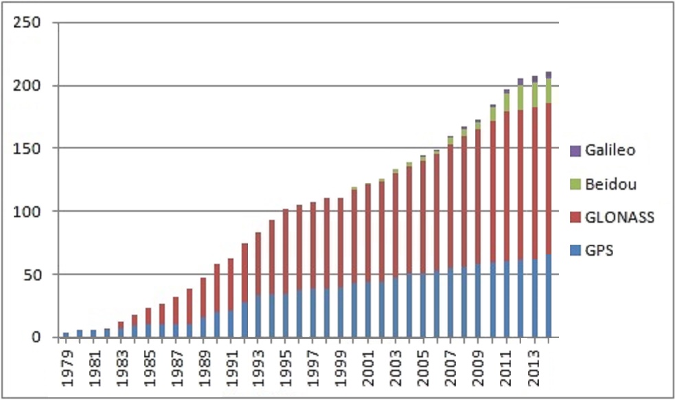
In order of first launch year:
GPS (1978)
Main article: Global Positioning System
The United States' Global Positioning System (GPS) consists of up to 32 medium Earth orbit satellites in six different orbital planes. The exact number of satellites varies as older satellites are retired and replaced. Operational since 1978 and globally available since 1994, GPS is the world's most used satellite navigation system.
GLONASS (1982)
Main article: GLONASS
The formerly Soviet, and now Russian, Global'naya Navigatsionnaya Sputnikovaya Sistema, (Global Navigation Satellite System or GLONASS), is a space-based satellite navigation system that provides a civilian radionavigation-satellite service and is also used by the Russian Aerospace Defence Forces. GLONASS has full global coverage since 1995 and with 24 active satellites.
BeiDou (2000)
Main article: BeiDou Navigation Satellite System
BeiDou started as the now-decommissioned Beidou-1, an Asia-Pacific local network on the geostationary orbits. The second generation of the system BeiDou-2 became operational in China in December 2011. The BeiDou-3 system is proposed to consist of 30 MEO satellites and five geostationary satellites (IGSO). A 16-satellite regional version (covering Asia and Pacific area) was completed by December 2012. Global service was completed by December 2018. On 23 June 2020, the BDS-3 constellation deployment is fully completed after the last satellite was successfully launched at the Xichang Satellite Launch Center.
Galileo (2011)
Main article: Galileo (satellite navigation)
The European Union and European Space Agency agreed in March 2002 to introduce their own alternative to GPS, called the Galileo positioning system. Galileo became operational on 15 December 2016 (global Early Operational Capability, EOC). At an estimated cost of €10 billion, the system of 30 MEO satellites was originally scheduled to be operational in 2010. The original year to become operational was 2014. The first experimental satellite was launched on 28 December 2005. Galileo is expected to be compatible with the modernized GPS system. The receivers will be able to combine the signals from both Galileo and GPS satellites to greatly increase the accuracy. The full Galileo constellation consists of 24 active satellites, the last of which was launched in December 2021. The main modulation used in Galileo Open Service signal is the Composite Binary Offset Carrier (CBOC) modulation.
Augmentation
GNSS augmentation is a method of improving a navigation system's attributes, such as accuracy, reliability, and availability, through the integration of external information into the calculation process, for example, the Wide Area Augmentation System, the European Geostationary Navigation Overlay Service, the Multi-functional Satellite Augmentation System, Differential GPS, GPS-aided GEO augmented navigation (GAGAN) and inertial navigation systems.
QZSS
Main article: Quasi-Zenith Satellite System
The Quasi-Zenith Satellite System (QZSS) is a four-satellite regional time transfer system and enhancement for GPS covering Japan and the Asia-Oceania regions. QZSS services were available on a trial basis as of January 12, 2018, and were started in November 2018. The first satellite was launched in September 2010. An independent satellite navigation system (from GPS) with 7 satellites is planned for 2023.
EGNOS
Comparison{{anchor|Signals}}
| System | BeiDou | Galileo | GLONASS | GPS | NavIC | QZSS | Owner | Coverage | Coding | Altitude | |||||||||||||||||||||||||||||
|---|---|---|---|---|---|---|---|---|---|---|---|---|---|---|---|---|---|---|---|---|---|---|---|---|---|---|---|---|---|---|---|---|---|---|---|---|---|---|---|
| km (mi) | Period | Rev./S. day | Satellites | Frequency | |||||||||||||||||||||||||||||||||||
| GHz | Status | Accuracy | |||||||||||||||||||||||||||||||||||||
| m (ft) | System | BeiDou | Galileo | GLONASS | GPS | NavIC | QZSS | ||||||||||||||||||||||||||||||||
| China | European Union | Russia | United States | India | Japan | ||||||||||||||||||||||||||||||||||
| Global | Global | Global | Global | Regional | Regional | ||||||||||||||||||||||||||||||||||
| CDMA | CDMA | FDMA & CDMA | CDMA | CDMA | CDMA | ||||||||||||||||||||||||||||||||||
| 21,150 km | 23,222 km | 19,130 km | 20,180 km | 36,000 km | 32,600-39,000 km | ||||||||||||||||||||||||||||||||||
| 12.88 h | |||||||||||||||||||||||||||||||||||||||
| (12 h 53 min) | 14.08 h | ||||||||||||||||||||||||||||||||||||||
| (14 h 5 min) | 11.26 h | ||||||||||||||||||||||||||||||||||||||
| (11 h 16 min) | 11.97 h | ||||||||||||||||||||||||||||||||||||||
| (11 h 58 min) | 23.93 h | ||||||||||||||||||||||||||||||||||||||
| (23 h 56 min) | 23.93 h | ||||||||||||||||||||||||||||||||||||||
| (23 h 56 min) | |||||||||||||||||||||||||||||||||||||||
| 13/7 | 17/10 | 17/8 | 2 | 1 | 1 | ||||||||||||||||||||||||||||||||||
| BeiDou-3: | |||||||||||||||||||||||||||||||||||||||
| 28 operational | |||||||||||||||||||||||||||||||||||||||
| (24 MEO, 3 IGSO, 1 GSO) | |||||||||||||||||||||||||||||||||||||||
| 5 in orbit validation | |||||||||||||||||||||||||||||||||||||||
| 2 GSO planned 20H1 | |||||||||||||||||||||||||||||||||||||||
| BeiDou-2: | |||||||||||||||||||||||||||||||||||||||
| 15 operational | |||||||||||||||||||||||||||||||||||||||
| 1 in commissioning | By design: | 24 by design | |||||||||||||||||||||||||||||||||||||
| 24 operational | |||||||||||||||||||||||||||||||||||||||
| 1 commissioning | |||||||||||||||||||||||||||||||||||||||
| 1 in flight tests | 24 by design30 operational | 8 operational | |||||||||||||||||||||||||||||||||||||
| (3 GEO, 5 GSO MEO) | 4 operational (3 GSO, 1 GEO) | ||||||||||||||||||||||||||||||||||||||
| 7 in the future | |||||||||||||||||||||||||||||||||||||||
| 1.561098 (B1) | |||||||||||||||||||||||||||||||||||||||
| 1.589742 (B1-2) | |||||||||||||||||||||||||||||||||||||||
| 1.20714 (B2) | |||||||||||||||||||||||||||||||||||||||
| 1.26852 (B3) | 1.559–1.592 (E1) | ||||||||||||||||||||||||||||||||||||||
| 1.164–1.215 (E5a/b) | |||||||||||||||||||||||||||||||||||||||
| 1.260–1.300 (E6) | 1.593–1.610 (G1) | ||||||||||||||||||||||||||||||||||||||
| 1.237–1.254 (G2) | |||||||||||||||||||||||||||||||||||||||
| 1.189–1.214 (G3) | 1.563–1.587 (L1) | ||||||||||||||||||||||||||||||||||||||
| 1.215–1.2396 (L2) | |||||||||||||||||||||||||||||||||||||||
| 1.164–1.189 (L5) | 1.57542 (L1) | ||||||||||||||||||||||||||||||||||||||
| 1.17645 (L5) | |||||||||||||||||||||||||||||||||||||||
| 2.49202 (S) | 1.57542 (L1C/A, L1C, L1S) | ||||||||||||||||||||||||||||||||||||||
| 1.22760 (L2C) | |||||||||||||||||||||||||||||||||||||||
| 1.17645 (L5, L5S) | |||||||||||||||||||||||||||||||||||||||
| 1.27875 (L6) | |||||||||||||||||||||||||||||||||||||||
| url=https://phys.org/news/2020-06-china-satellite-gps-like-beidou.html | title=China launches final satellite in GPS-like Beidou system | publisher=phys.org | access-date=24 June 2020 | archive-url=https://web.archive.org/web/20200624080233/https://phys.org/news/2020-06-china-satellite-gps-like-beidou.html | archive-date=24 June 2020 | url-status=live}} | url= http://aviationweek.com/world-satellite-business-week/rise-new-navigation-satellites | url-access=subscription | title= The Rise Of New Navigation Satellites | date= Sep 12, 2018 | author1=Irene Klotz | author2=Tony Osborne | author3=Bradley Perrett | work= Aviation Week Network | url-status=live | archive-url=https://web.archive.org/web/20231025102726/https://aviationweek.com/defense-space/space/rise-new-navigation-satellites | archive-date=Oct 25, 2023 }} | Operational | Operational | Operational | Operational | ||||||||||||||||||
| 3.6 m (public) | |||||||||||||||||||||||||||||||||||||||
| 0.1 m (encrypted) | 0.2 m (public) | ||||||||||||||||||||||||||||||||||||||
| 0.01 m (encrypted) | 2 - | 0.3 - | |||||||||||||||||||||||||||||||||||||
| (no DGPS or WAAS) | 1 m (public) | ||||||||||||||||||||||||||||||||||||||
| 0.1 m (encrypted) | 1 m (public) | ||||||||||||||||||||||||||||||||||||||
| 0.1 m (encrypted) | |||||||||||||||||||||||||||||||||||||||
| Sources: |
Using multiple GNSS systems for user positioning increases the number of visible satellites, improves precise point positioning (PPP) and shortens the average convergence time. The signal-in-space ranging error (SISRE) in November 2019 were 1.6 cm for Galileo, 2.3 cm for GPS, 5.2 cm for GLONASS and 5.5 cm for BeiDou when using real-time corrections for satellite orbits and clocks. The average SISREs of the BDS-3 MEO, IGSO, and GEO satellites were 0.52 m, 0.90 m and 1.15 m, respectively. Compared to the four major global satellite navigation systems consisting of MEO satellites, the SISRE of the BDS-3 MEO satellites was slightly inferior to 0.4 m of Galileo, slightly superior to 0.59 m of GPS, and remarkably superior to 2.33 m of GLONASS. The SISRE of BDS-3 IGSO was 0.90 m, which was on par with the 0.92 m of QZSS IGSO. However, as the BDS-3 GEO satellites were newly launched and not completely functioning in orbit, their average SISRE was marginally worse than the 0.91 m of the QZSS GEO satellites.
International regulation
The International Telecommunication Union (ITU) defines a radionavigation-satellite service (RNSS) as "a radiodetermination-satellite service used for the purpose of radionavigation. This service may also include feeder links necessary for its operation".
RNSS is regarded as a safety-of-life service and an essential part of navigation which must be protected from interferences.
** Aeronautical radionavigation-satellite ** (ARNSS) is – according to Article 1.47 of the International Telecommunication Union's (ITU) Radio Regulations (RR) – defined as «A radionavigation service in which earth stations are located on board aircraft.»
** Maritime radionavigation-satellite service ** (MRNSS) is – according to Article 1.45 of the International Telecommunication Union's (ITU) Radio Regulations (RR) – defined as «A radionavigation-satellite service in which earth stations are located on board ships.»
Classification
ITU Radio Regulations (article 1) classifies radiocommunication services as:
- Radiodetermination service (article 1.40)
- Radiodetermination-satellite service (article 1.41)
- Radionavigation service (article 1.42)
- Radionavigation-satellite service (article 1.43)
- Maritime radionavigation service (article 1.44)
- Maritime radionavigation-satellite service (article 1.45)
- Aeronautical radionavigation service (article 1.46)
- Aeronautical radionavigation-satellite service (article 1.47)
; Examples of RNSS use
- Augmentation system GNSS augmentation
- Automatic Dependent Surveillance–Broadcast
- BeiDou Navigation Satellite System (BDS)
- GALILEO, European GNSS
- Global Positioning System (GPS), with Differential GPS (DGPS)
- GLONASS
- NAVIC
- Quasi-Zenith Satellite System (QZSS)
Frequency allocation
The allocation of radio frequencies is provided according to Article 5 of the ITU Radio Regulations (edition 2012).
To improve harmonisation in spectrum usage, most service allocations are incorporated in national Tables of Frequency Allocations and Utilisations within the responsibility of the appropriate national administration. Allocations are:
- primary: indicated by writing in capital letters
- secondary: indicated by small letters
- exclusive or shared usage: within the responsibility of administrations.
Alternatives
Alternative Positioning, Navigation and Timing (AltPNT) refers to the concept of as an alternative to GNSS. Such alternatives include:
- Inertial navigation systems (INS)
- eLORAN
- Terrain-based navigation (TBN)
- Visual Positioning Systems (VPS)
- LiDAR
Notes
References
References
- (24 June 2020). "China's GPS rival Beidou is now fully operational after final satellite launched". cnn.com.
- (26 January 2024). "Galileo is the European global satellite-based navigation system".
- Kishimoto, Motohisa. (2024-12-13). "The status of QZSS".
- "IRNSS Programme".
- "IRNSS".
- (23 January 2019). "Japan Prepares for GPS Failure with Quasi-Zenith Satellites".
- "A Beginner's Guide to GNSS in Europe". IFATCA.
- "Galileo General Introduction - Navipedia".
- "GNSS signal - Navipedia".
- (9 January 2018). "Investigation on Reference Frames and Time Systems in Multi-GNSS". Remote Sensing.
- Jury, H, 1973, Application of the Kalman Filter to Real-time Navigation using Synchronous Satellites, Proceedings of the 10th International Symposium on Space Technology and Science, Tokyo, 945-952.
- "Relativistic Effects on the Satellite Clock". The Pennsylvania State University.
- (2011-08-18). "Applications".
- (2012-03-08). "China's GPS rival is switched on". BBC News.
- "The BDS-3 Preliminary System Is Completed to Provide Global Services".
- "APPLICATIONS-Transport".
- (14 December 2016). "Galileo goes live!". europa.eu.
- (25 August 2006). "Boost to Galileo sat-nav system". BBC News.
- (2010-01-07). "Commission awards major contracts to make Galileo operational early 2014".
- (2005-12-28). "GIOVE-A launch News".
- (23 December 2016). "Galileo begins serving the globe". INTERNATIONALES VERKEHRSWESEN.
- (19 May 2020). "Soyuz launch from Kourou postponed until 2021, 2 others to proceed". Space Daily.
- (9 December 2016). "Galileo Initial Services".
- "India to develop its own version of GPS". Rediff.com.
- S. Anandan. (2010-04-10). "Launch of first satellite for Indian Regional Navigation Satellite system next year". Beta.thehindu.com.
- "IRNSS Programme - ISRO".
- (2007-09-05). "India to build a constellation of 7 navigation satellites by 2012". Livemint.com.
- Rohit KVN. (28 May 2017). "India's own GPS IRNSS NavIC made by ISRO to go live in early 2018".
- IANS. (2017-06-10). "Navigation satellite clocks ticking; system to be expanded: ISRO". The Economic Times.
- Koshy, Jacob. (October 26, 2022). "ISRO to boost NavIC, widen user base of location system". [[The Hindu]].
- "About QZSS". JAXA.
- (15 May 2017). "Japan mulls seven-satellite QZSS system as a GPS backup".
- (9 October 2017). "Japan's H-2A conducts QZSS-4 launch".
- "Information and Analysis Center for Positioning, Navigation and Timing".
- "GPS Space Segment".
- "送信信号一覧".
- "China launches final satellite in GPS-like Beidou system". phys.org.
- (Sep 12, 2018). "The Rise Of New Navigation Satellites". Aviation Week Network.
- (2023-08-23). "Handbook of Metrology and Applications". Springer Nature.
- (August 2023). "NAVIC SIGNAL IN SPACE ICD FOR STANDARD POSITIONING SERVICE IN L1 FREQUENCY".
- (2019). "Assessing the latest performance of Galileo-only PPP and the contribution of Galileo to Multi-GNSS PPP". Advances in Space Research.
- (2020). "Evolution of orbit and clock quality for real-time multi-GNSS solutions". GPS Solutions.
- "DORIS information page". Jason.oceanobs.com.
- "Globalstar GSP-1700 manual".
- Rickerson, Don. (January 2005). "Iridium SMS and SBD". Personal Satellite Network, Inc..
- ITU Radio Regulations, Section IV. Radio Stations and Systems – Article 1.43, definition: ''radionavigation-satellite service ''
- ITU Radio Regulations, Section IV. Radio Stations and Systems – Article 1.47, definition: ''aeronautical radionavigation service ''
- ITU Radio Regulations, Section IV. Radio Stations and Systems – Article 1.45, definition: ''maritime radionavigation-satellite service''
- ''ITU Radio Regulations, CHAPTER II – Frequencies, ARTICLE 5 Frequency allocations, Section IV – Table of Frequency Allocations''
- Gorman, Sean. (July 2, 2024). "Can "AltPNT" Really Replace GPS?".
This article was imported from Wikipedia and is available under the Creative Commons Attribution-ShareAlike 4.0 License. Content has been adapted to SurfDoc format. Original contributors can be found on the article history page.
Ask Mako anything about Satellite navigation — get instant answers, deeper analysis, and related topics.
Research with MakoFree with your Surf account
Create a free account to save articles, ask Mako questions, and organize your research.
Sign up freeThis content may have been generated or modified by AI. CloudSurf Software LLC is not responsible for the accuracy, completeness, or reliability of AI-generated content. Always verify important information from primary sources.
Report