From Surf Wiki (app.surf) — the open knowledge base
Sangre de Cristo Mountains
Mountain range in Colorado and New Mexico, United States

Mountain range in Colorado and New Mexico, United States
| Field | Value |
|---|---|
| name | Sangre de Cristo Mountains |
| photo | MtBlancaEast.jpg |
| photo_caption | Blanca Peak |
| etymology | *Sangre de Cristo* () |
| country | United States |
| subdivision1_type | States |
| subdivision1 | |
| parent | Rocky Mountains |
| area_mi2 | 17193 |
| length_mi | 242 |
| length_orientation | north-south |
| width_mi | 120 |
| width_orientation | east-west |
| highest | Blanca Peak |
| elevation_ft | 14351 |
| coordinates | |
| highest_location | East of Alamosa, Colorado |
| listing | Mountain ranges of Colorado |
the greater Sangre de Cristo mountain range
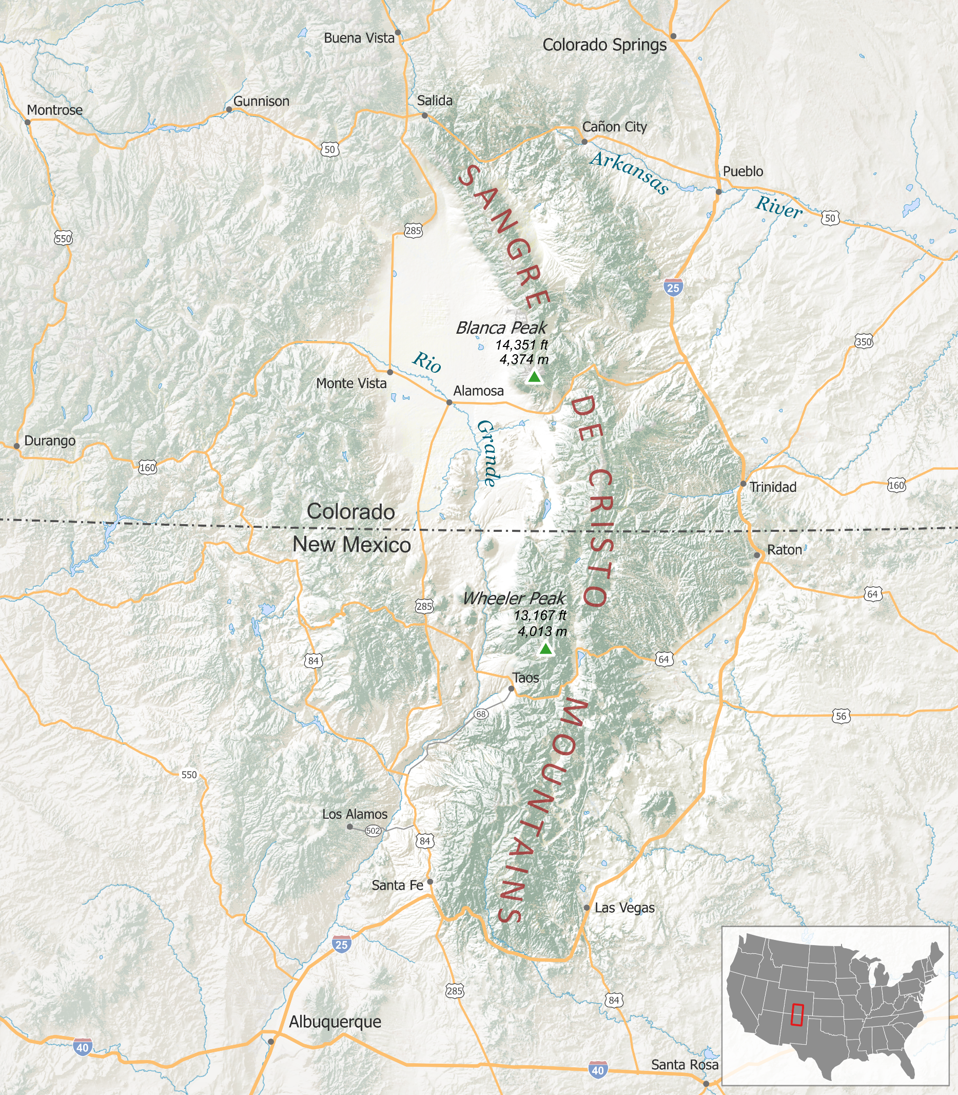
The Sangre de Cristo Mountains (Spanish for "Blood of Christ") are the southernmost subrange of the Rocky Mountains. They are located in southern Colorado and northern New Mexico in the United States. The mountains run from Poncha Pass in South-Central Colorado, trending southeast and south, ending at Glorieta Pass, southeast of Santa Fe, New Mexico. The mountains contain a number of fourteen thousand foot peaks in the Colorado portion, as well as several peaks in New Mexico which are over thirteen thousand feet.
The name of the mountains may refer to the occasional reddish hues observed during sunrise and sunset, and when alpenglow occurs, especially when the mountains are covered with snow. Although the particular origin of the name is unclear, it has been in use since the early 19th century. Before that time the terms "La Sierra Nevada", "La Sierra Madre", "La Sierra", and "The Snowies" (used by English speakers) were used. According to legend, "sangre de Cristo" were the last words of a priest who was killed by Native Americans.
Land management and recreation overview

Much of the mountains are within various National Forests: the Rio Grande and San Isabel in Colorado, and the Carson and Santa Fe in New Mexico. These publicly accessible areas are managed by the United States Forest Service and are popular for hunting, camping, hiking, mountain biking, backpacking, climbing, and cross-country and downhill skiing.
The mountains include two large wilderness areas, the Sangre de Cristo Wilderness in Colorado and the Pecos Wilderness in New Mexico, as well as some smaller wilderness areas, such as Latir Peak Wilderness. The Great Sand Dunes National Park and Preserve lies on the southwest side of the mountains in Colorado and are managed by the National Park Service.
Subranges
The Sangre de Cristo Mountains are divided into various subranges, described here from north to south. Use of the terms "Sangre de Cristo Range" and "Sangre de Cristo Mountains" is inconsistent and may refer to the northernmost subrange, the southernmost subrange, or the mountains as a whole.
Sangre de Cristo Range
Main article: Sangre de Cristo Range
The Sangre de Cristo Range, the largest and most northerly subrange of the Sangre de Cristo Mountains, runs directly along the east side of the Rio Grande rift, extending southeast from Poncha Pass for about 75 miles (120 km) through south-central Colorado to La Veta Pass, approximately 20 miles (32 km) west of Walsenburg. They form a high ridge separating the San Luis Valley on the west from the watershed of the Arkansas River on the east.
Crestones
The Crestones are a group of four 14000 ft+ peaks (fourteeners) in the Sangre de Cristo Range above Crestone, Colorado.
Spanish Peaks
The Spanish Peaks are a pair of mountains, West Spanish Peak, 13626 ft, and East Spanish Peak, 12860 ft, located in southwestern Huerfano County, Colorado. The Spanish Peaks were designated a National Natural Landmark in 1976 as one of the best known examples of igneous dikes.{{cite web
Culebra Range
The Culebra Range runs almost due north and south, with its northern limit at La Veta Pass in Colorado, and its southern limit at Costilla Creek, just south of Big Costilla Peak in New Mexico. Its highest point is Culebra Peak at 14047 ft, which is notable for being the only fourteener in Colorado on private land with an access fee. Climbers wishing to ascend Culebra must pay a fee (currently US$150 per person), and the number of climbers per year is limited. It is also the most southerly fourteener in the U.S. Rockies. Standing to the east of the main crest are the two prominent Spanish Peaks (West: 13626 ft, East: 12860 ft). These peaks were important landmarks for 19th century travelers on the mountain branch of the Santa Fe Trail.
The western slope of the Culebras and the San Luis Valley are located within the Sangre de Cristo Land Grant, dating back to the 1840s but still a factor in the pattern of land ownership within the grant. The San Luis Valley is arid. The town of San Luis, Colorado has an annual precipitation of only 9.6 inch.The surrounding area, traversed by Culebra Creek, has a rich agricultural history and has been the scene of land disputes between the descendants of Hispanic settlers and Anglo ranchers since the 1860s.
Taos Mountains
The Taos Mountains span the western lobe of the range from Costilla Creek in the north, to Tres Ritos in the south. They include the highest point in New Mexico, Wheeler Peak, at 13161 ft, which is part of the Wheeler Peak Wilderness. Other notable peaks include Pueblo Peak, which at 12305 ft rises dramatically above Taos Pueblo, and Latir Peak, at 12708 ft. Williams Lake is located below Wheeler Peak in the Wheeler Peak Wilderness.
Taos Ski Valley lies just to the west of Wheeler Peak. Much of the central portion of the Taos Mountains is on Taos Pueblo land. As viewed from Taos, they are locally called "Taos Mountain."
The southern portion of the Taos Mountains, between Palo Flechado Pass and Tres Ritos (U.S. Route 64 and NM Route 518), is lower and less dramatic than the northern section, with its high point being Cerro Vista, 11939 ft. The Fernando Mountains are a small subrange lying in this section, just south of US Route 64.
Cimarron Range
Main article: Cimarron Range, New Mexico
The Cimarron Range lies across the Moreno Valley to the east of the Taos Mountains. It is a lower range, with its highest point being Baldy Mountain at 12441 ft. The Philmont Scout Ranch lies on the east side of the Cimarron Range.
Rincon Mountains
This is a minor subrange, significantly lower than the rest of the Sangre de Cristos; it lies east of the southernmost portion of the Taos Mountains.
Santa Fe Mountains
Rounding out the Sangre de Cristo Mountains are the Santa Fe Mountains, which include all peaks south of NM Route 518. This group lies near Santa Fe and surrounds the Pecos Wilderness, which protects the source watershed of the Pecos River. The peaks include Truchas Peak, 13102 ft, as their highest point. Other notable peaks are Santa Fe Baldy (12622 ft) and Jicarita Peak (12835 ft). The Pecos Wilderness is crossed by many trails and is popular for backpacking and for fishing in its high alpine lakes.
Prominent peaks
| Rank | Mountain Peak | Subrange | Elevation | Prominence | Isolation | Image | Comment | |
|---|---|---|---|---|---|---|---|---|
| 1 | Blanca Peak | Sierra Blanca | [[File:BLANCA.JPG | 175px]] | Blanca Peak in Colorado is the highest peak of the Sangre de Cristo mountains. | |||
| 2 | Crestone Peak | Crestones | [[File:Crestone peaks fall.jpg | 175px]] | Crestone Peak is rock scrambles (Class 3) with some exposure and significant rockfall danger. (Image: Crestone Peak and Crestone Needle seen from the south) | |||
| 3 | Culebra Peak | Culebra Range | [[File:Big Costilla Peak.jpg | 175px]] | (Image: Big Costilla Peak in the Culebra Range, viewed from Valle Vidal.) | |||
| 4 | West Spanish Peak | Spanish Peaks | [[File:West-spanish-peak02.jpg | 175px]] | (Image: West Spanish Peak taken from the south) | |||
| 5 | Mount Herard | Sangre de Cristo Range | [[File:Great Sand Dunes NP 1.JPG | 175px]] | (Image: Sangre de Cristo range from the Great Sand Dunes National Park) | |||
| 6 | Wheeler Peak | Taos Mountains | [[File:Wheeler Peak from Phillips.jpg | 175px]] | Wheeler Peak, of the Wheeler Peak Wilderness, is the highest peak in New Mexico. Taos Ski Valley lies just to the west of Wheeler Peak. Much of the central portion of the Taos Mountains are on Taos Pueblo land. As viewed from Taos, they are locally called "Taos Mountain." | |||
| 7 | Bushnell Peak | Sangre de Cristo Range | ||||||
| 8 | Truchas Peak | Santa Fe Mountains | [[File:Truchas peak winter.jpg | 175px]] | Truchas Peak is the highest point in the Santa Fe Mountains. (Image: Truchas Peak in winter from Española, New Mexico) | |||
| 9 | Venado Peak | Taos Mountains | [[File:Taos Mountain at Sunset (2973710102).jpg | 175px]] | (Image: Taos Mountain at sunset.) | |||
| 10 | East Spanish Peak | Spanish Peaks | [[File:Spanish Peaks.JPG | 175px]] | East Spanish Peak is the lower of the two Spanish Peaks, two large igneous stocks which form an eastern outlier of the Culebra Range, a subrange of the Sangre de Cristo Mountains. (Image: Spanish Peaks as seen from I25, Huerfano county, Colorado) | |||
| 11 | Santa Fe Baldy | Santa Fe Mountains | [[File:Santa Fe Baldy with cloud from White Rock.jpg | 175px]] | Santa Fe Baldy is a prominent summit in the Sangre de Cristo Mountains of New Mexico, located 15 mi (24 km) northeast of Santa Fe. It is prominent as seen from Los Alamos and communities along the Rio Grande in northern New Mexico, but is relatively inconspicuous from Santa Fe, as its north-south trending main ridge line is seen nearly end-on, disguising the size of the mountain. Santa Fe Baldy lies in the Pecos Wilderness within the Santa Fe National Forest, on the water divide between the Rio Grande and the Pecos River. | |||
| 12 | Baldy Mountain | Cimarron Range | [[File:Philmont Scout Ranch Baldy Mountain from Copper Park.jpg | 175px]] | (Image: Baldy Peak summit ridge in the Cimarron Range.) | |||
| 13 | Greenhorn Mountain | Wet Mountains | [[File:San Isabel View of Greenhorn Mountain.jpg | 175px]] | Greenhorn Mountain is the highest point in the Wet Mountains of southern Colorado, just high enough to pass tree line which is about 11500 ft in this part of Colorado. The massive mountain can be seen from Pueblo and all along Interstate 25. The mountain is protected within the secluded Greenhorn Mountain Wilderness Area but is accessed by a few trails and a nearby 4-wheel drive road to the north. | |||
| 14 | Mount Zwischen | Sangre de Cristo Range | [[File:Mount Zwischen.JPG | 175px]] | (Image:Mount Zwischen, east aspect) | |||
| 15 | Cerro Vista | Cerro Vista | ||||||
| 16 | Mount Phillips | Cimarron Range | [[File:Mount Phillips NM.jpg | 175px]] | Mount Phillips, formerly called Clear Creek Mountain, is located in Colfax County about 11 mi (17 km) south of Baldy Mountain in the Cimarron Range, a subrange of the Sangre de Cristo Mountains of New Mexico. The peak was renamed in 1960 in honor of Waite Phillips, who donated the area to the Boy Scouts of America. (Image: Mount Phillips (tallest mountain, at center) seen from Baldy Mountain) | |||
| 17 | Mount Mestas | Sierra Blanca | [[File:Mount Mestas.JPG | 175px]] | ||||
| 18 | Iron Mountain | Sierra Blanca | [[File:Iron Mountain (Sangre de Cristo Range).JPG | 175px]] |
Geology
The Sangre de Cristo Mountains were uplifted during the Cenozoic Laramide orogeny. They are bounded on the west by the Rio Grande rift and on the east by a series of reverse and thrust faults. Vertical displacement along the faults is at least 4200 m, and gravity measurements suggest the uplift has been thrust eastward great distances. This faulting places Precambrian basement rock in contact with sedimentary strata along the eastern margin of the uplift except where igneous rocks have been intruded along the fault.
Notes
References
References
- Julyan, Robert. (1998). "The Place Names of New Mexico". University of New Mexico Press.
- Dawson, John Frank. (1954). "Place names in Colorado: why 700 communities were so named, 150 of Spanish or Indian origin". The J. Frank Dawson Publishing Co..
- Chronic, Halka. (1998). "Roadside Geology of Colorado". Mountain Press Publishing Company.
- "Culebra Peak | Colorado Fourteeners Initiative".
- "Colorado Fourteeners Initiative: Peaks: Sangre de Cristo Range: Culebra Peak".
- "Climate San Luis".
- (2006). "Mike Butterfield's Guide to the Mountains of New Mexico". New Mexico Magazine Press.
- The elevation of this summit has been converted from the [[National Geodetic Vertical Datum of 1929]] (NGVD 29) to the [[North American Vertical Datum of 1988]] (NAVD 88). [http://www.ngs.noaa.gov/faq.shtml#WhatVD29VD88 National Geodetic Survey]
- {{cite ngs. FN0666. Truchas Peak. 2 January 2023
- {{cite ngs. FN0726. Santa Fe Baldy
- {{cite ngs. GM0775. Baldy Mountain
- {{cite ngs. HK0512. Greenhorn Mountain
- (1987). "Tectonic framework of northeastern New Mexico and adjacent parts of Colorado, Oklahoma and Texas". New Mexico Geological Society Field Conference Series.
This article was imported from Wikipedia and is available under the Creative Commons Attribution-ShareAlike 4.0 License. Content has been adapted to SurfDoc format. Original contributors can be found on the article history page.
Ask Mako anything about Sangre de Cristo Mountains — get instant answers, deeper analysis, and related topics.
Research with MakoFree with your Surf account
Create a free account to save articles, ask Mako questions, and organize your research.
Sign up freeThis content may have been generated or modified by AI. CloudSurf Software LLC is not responsible for the accuracy, completeness, or reliability of AI-generated content. Always verify important information from primary sources.
Report