From Surf Wiki (app.surf) — the open knowledge base
Petermann Island
Island of Antarctica

Island of Antarctica
| Field | Value |
|---|---|
| name | Petermann Island |
| image_name | Petermann Island all.jpg |
| image_caption | Petermann Island from a distance |
| pushpin_map | Antarctica#Antarctic Peninsula |
| map_relief | yes |
| pushpin_map_caption | Location of Petermann Island |
| location | Antarctica |
| coordinates | |
| length_km | 2 |
| country | Antarctica |
| treaty_system | Antarctic Treaty System |
Petermann Island () is an island 1 nmi long, lying 1 nmi southwest of Hovgaard Island in the Wilhelm Archipelago, Antarctica.
Location
Petermann Island is off the Graham Coast of the Antarctic Peninsula. It is in the Wilhelm Archipelago, southwest of Hovgaard Island and Booth Island, east of the Vedel Islands and northeast of the French Passage. It is northwest of Mount Shackleton on the mainland.
The island is 1.8 km long and 1.2 km across. It rises steeply to elevations of up to 250 m from a rocky coastline with raised pebble beaches. It has volcanic origins, with about half the land surface covered by a permanent, crevassed icecap. Ice-free areas have a sparse vegetation of mosses and lichens. The bedrock of the island is granodiorite.
Important Bird Area

The island has been identified as an Important Bird Area (IBA) by BirdLife International because it supports a breeding colony of about 3,000 pairs of gentoo penguins. Other birds nesting at the site in smaller numbers include Adélie penguins, imperial shags, Wilson's storm petrels and south polar skuas.
Sailing directions
The US Defense Mapping Agency's Sailing Directions for Antarctica (1976) describes Petermann Island as follows: This peak is flanked on each side by low peninsulas deeply cut by small fiords. The Southwest fiord, although offering depths of 6.4m (3 1/2 fm) to 23.8m (13 fm) is not a favorable harbor because heavy swells enter as well as much drift ice. The ice cliffs at the head of the fiord frequently calve making the anchorage uncomfortable for vessels. The Ice cliffs offer no shore anchorage for moorings. The Northeast fiord offers depths of 15.5m (8 1/2 fm) but is open to prevailing winds, and ice blocks the fiord at each storm. The eastern fiord Is called Port Circumcision (Port Circoncision), and It was here that Dr. Charcot wintered the Pourquoi Pas in 1909, Two shoals with 2.7m (1 1/2 fm) of water over them lie to northward and to southward of the entrance of the harbor but do not obstruct the entrance. Vessels entering should approach from the southeastward and steer to enter midway between the entrance points; the channel between the flanking shoals has a minimum depth of 8.2m (4 1/2 fm). The harbor offers a shelter for small vessels which may be moored alongside the rocky shores in the head of the fiord, where depths of 5.5m (3 fm) to 8.2m (4 1/2 fm) are found. Vessels wintering in this site should moor by anchor cable to suitable points on the shore as well as taking anchorage underfoot. Barriers of chain should be erected across the harbor entrance to prevent damage to the vessel by drifting ice. At least one fathom of water should be kept under the vessel for waves several feet high have been experienced here as well as a strong undertow. The fiord is exposed to northeast winds, and is not recommended for winter quarters. An Argentine station is located on the southern shore of Port Circumcision.}}
History
Petermann Island was discovered by a German expedition 1873–74, and named by Eduard Dallmann for August Petermann, noted German geographer and founder of Petermanns Mitteilungen. The United States Advisory Committee on Antarctic Names (US-ACAN) has rejected the name Lund Island, applied by the Belgian Antarctic Expedition (BelgAE), 1897–99, in favor of the original naming. The French Antarctic Expedition (FrAE) of 1908-10 under Jean-Baptiste Charcot wintered over aboard ship in a cove on the southeast side of the island, named Port Circumcision because it was spotted 1 January 1909, the traditional day for the Feast of the Circumcision. Huts built by the expedition are gone, although a cairn remains, along with a refuge hut built by Argentina in 1955, and a cross commemorating three members of the British Antarctic Survey who died in a 1982 attempt to cross the sea ice from Petermann to Faraday Station.
Megalestris Hill Cairn
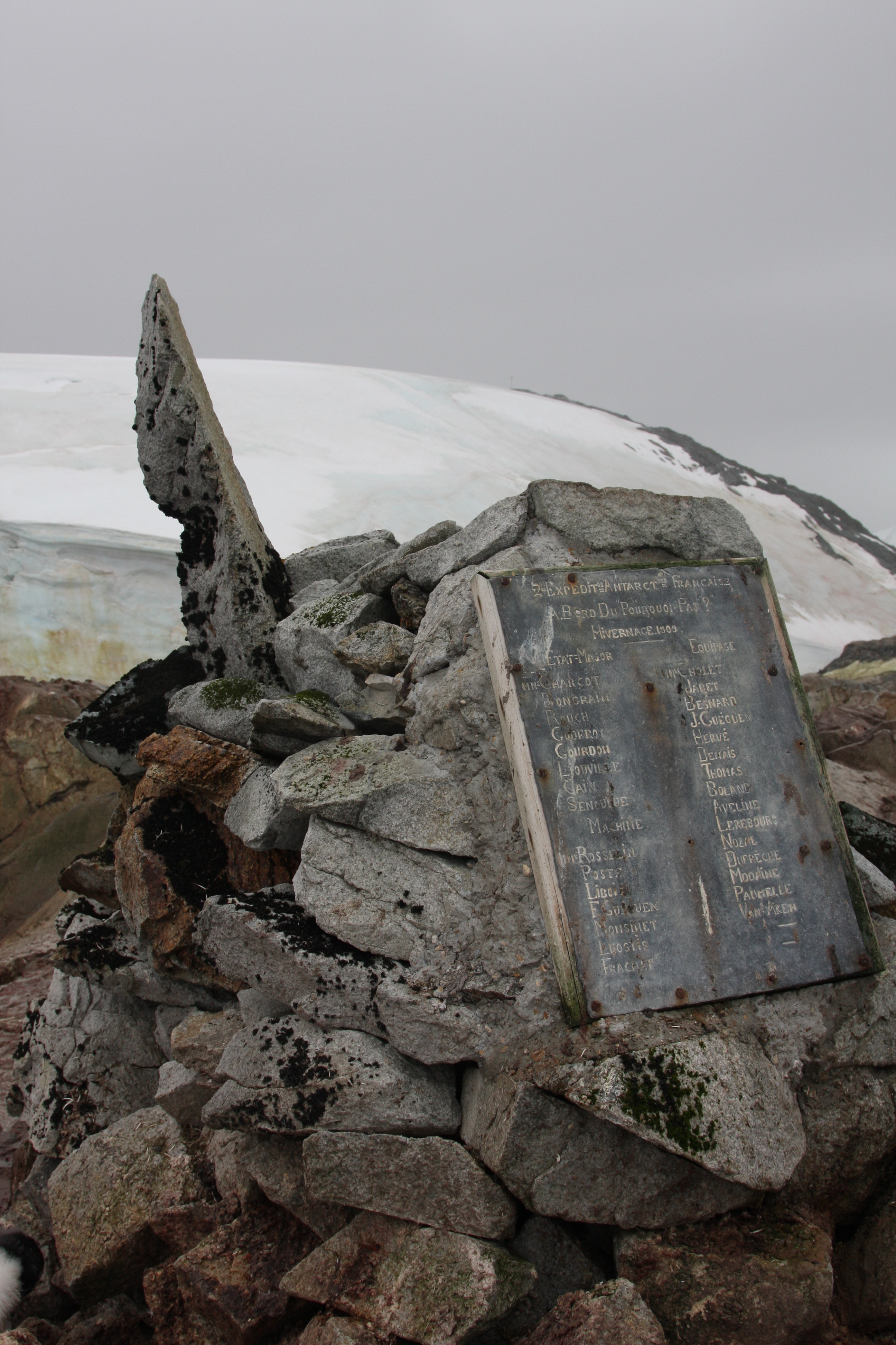
A cairn with a lead plaque was erected on Megalestris Hill in 1909. The original plaque has since been removed to the Museum National d’Histoire Naturelle in Paris, but the cairn, with a replica plaque, has been designated a Historic Site or Monument (HSM 27), following a proposal by Argentina, France and the United Kingdom to the Antarctic Treaty Consultative Meeting.
Groussac Refuge
Main article: Groussac Refuge
Groussac Refuge () is an Argentine naval refuge (originally called Hippolyte Bouchard) in Antarctica, located on the southern coast of the Port Circumcision, on Petermann Island. The refuge was inaugurated on February 6, 1955, and is operated by the Argentine Navy and was occupied periodically by personnel of the British Antarctic Survey of the former Faraday Station. The refuge is in the middle of a colony of Gentoo penguins. Its current name is in honour of Paul Groussac, a French writer and historian who lived in Argentina and authored a plea on the Argentine claim of the Malvinas Islands and biographies of Argentine national heroes.
Features
The level-3 headings in the list below are the targets of redirects, e.g. Rouch Point goes to Petermann Island#Rouch Point. If you choose to convert the list to a more compact form, please keep the targets as anchors, for example
- Rouch Point Rouch Point {coord|65|10|S|64|11|W}}. A point forming the northwest end .. But first, check the appearance on a smartphone --
Rouch Point
Godfroy Point
Liouville Point
Depeaux Point
Port Circumcision
Clayton Hill
Megalestris Hill

Nearby features
Herald Reef
Barbière Island
Charlat Island
Thiébault Island
Boudet Island
Bazzano Island
Lisboa Island
References
Sources
- {{citation|url=https://pubs.usgs.gov/fedgov/70039167/report.pdf |accessdate=2023-12-03 |edition=2 |editor-last=Alberts |title=Geographic Names of the Antarctic |editor-first=Fred G.
- {{citation |url=https://collections.lib.uwm.edu/digital/collection/agdm/id/7696/ |accessdate=2024-05-03
- {{citation |url= http://www.ats.aq/documents/ATCM35/WW/atcm35_ww003_e.pdf |ref=
- {{citation |url= https://datazone.birdlife.org/site/factsheet/petermann-island-iba-antarctica |ref=
- {{citation |url=https://books.google.com/books?id=b-FwBY8bia0C&pg=PA168|accessdate=2024-05-30 |ref=
- {{citation |publisher=Springer Science & Business Media|isbn=978-3-642-23462-0
This article was imported from Wikipedia and is available under the Creative Commons Attribution-ShareAlike 4.0 License. Content has been adapted to SurfDoc format. Original contributors can be found on the article history page.
Ask Mako anything about Petermann Island — get instant answers, deeper analysis, and related topics.
Research with MakoFree with your Surf account
Create a free account to save articles, ask Mako questions, and organize your research.
Sign up freeThis content may have been generated or modified by AI. CloudSurf Software LLC is not responsible for the accuracy, completeness, or reliability of AI-generated content. Always verify important information from primary sources.
Report