From Surf Wiki (app.surf) — the open knowledge base
Paracel Islands
Disputed islands in the South China Sea
Disputed islands in the South China Sea
| Field | Value |
|---|---|
| disputed | yes |
| name | Paracel Islands |
| plural | yes |
| image_name | Asia - South China Sea - Mui Da Nang to Shen-Ch'uan Chiang including Hai-Nan Tao and Paracel Islands (Paracel Islands cropped).jpg |
| image_size | 300px |
| image_caption | Nautical chart of the Paracel Islands |
| pushpin_map | South China Sea |
| map_caption | Location of the Paracel Islands within the South China Sea |
| location | South China Sea |
| coordinates | |
| total_islands | Over 30 |
| major_islands | Woody, Rocky, Tree, Money, Robert, Pattle, Triton, Duncan, Lincoln, Drummond |
| area_km2 | 7.75 |
| area_footnotes | (15,000 sq km ocean surface) |
| coastline_km | 518 |
| elevation_m | 14 |
| highest_mount | Rocky Island |
| country | (de facto since 1974) |
| country_admin_divisions_title | Province |
| country_admin_divisions | Hainan |
| country_admin_divisions_title_1 | Prefecture-level city |
| country_admin_divisions_1 | Sansha |
| country_admin_divisions_title_2 | District |
| country_admin_divisions_2 | Xisha District |
| country2 | |
| country2_admin_divisions_title | Municipality |
| country2_admin_divisions | Kaohsiung |
| country3 | |
| country3_admin_divisions_title | Municipality |
| country3_admin_divisions | Da Nang |
| population | Over 1,000 |
| population_as_of | 2014 |
| additional_info | {{Infobox Chinese |
| child | yes |
| t | 西沙群島 |
| s | 西沙群岛 |
| l | Western Sandy Archipelago |
| p | Xīshā Qúndǎo |
| w | Hsi-sha Ch'ün-tao |
| j | Sai1-saa1 Kwan4-dou2 |
| hain | Sa-so Kún-tō |
| vie | Quần đảo Hoàng Sa |
| hn | 群 |
| order | st |
'Xisha' redirects here. For other places known by that name, see Xisha (disambiguation).}}{{Use mdy dates
The Paracel Islands, also known as the Hoàng Sa Archipelago () and the Xisha Islands (), is a disputed archipelago in the South China Sea and currently controlled by the People's Republic of China.
The word paracel is of Portuguese origin, meaning placer (a submerged bank or reef), and appears on 16th-century Portuguese maps. The archipelago includes about 130 small coral islands and reefs, most grouped into the northeastern Amphitrite Group or the western Crescent Group. They are distributed over a maritime area of around 15000 km2, with a land area of approximately 7.75 km2. The archipelago is located about 220 miles (350 km) southeast of Hainan Island, equidistant from the coastlines of the People's Republic of China (PRC) and Vietnam, and approximately one-third of the way between central Vietnam and the northern Philippines. A feature of the Paracel Islands is Dragon Hole, the second deepest blue hole (underwater sinkhole) in the world. Sea turtles and seabirds are native to the islands, which have a hot and humid climate, abundant rainfall and may experience annual typhoons. The archipelago is surrounded by productive fishing grounds and a seabed potentially containing unexplored oil and gas reserves.
Geography
- Geographic coordinates:
- Coastline: 518 km
- Climate: tropical
- Elevation extremes:
- Lowest point: South China Sea, sea level
- Highest point: unnamed location on Rocky Island 14 m
- Natural resources: fish, coral reefs, possible reserves of oil and gas of unknown size
- Natural hazards: typhoons
Climate
The climate is different from nearby continental land masses with the lower air mass temperatures being 1 to cooler than land at the same latitude, and with higher relative humidity due to the maritime air mass. The air mass over the Paracel Islands has about a 5 C-change variation in annual temperature compared to the 2.2 C-change observed over the Spratly Islands.
| Jan record high C = 31.3 | Feb record high C = 30.8 | Mar record high C = 33.1 | Apr record high C = 34.3 | May record high C = 35.9 | Jun record high C = 35.9 | Jul record high C = 35.1 | Aug record high C = 35.0 | Sep record high C = 34.0 | Oct record high C = 34.1 | Nov record high C = 32.8 | Dec record high C = 30.4 | year record high C = 35.9 | Jan record low C = 14.9 | Feb record low C = 18.1 | Mar record low C = 18.7 | Apr record low C = 19.1 | May record low C = 21.7 | Jun record low C = 23.0 | Jul record low C = 22.4 | Aug record low C = 21.0 | Sep record low C = 21.6 | Oct record low C = 21.2 | Nov record low C = 18.9 | Dec record low C = 13.8 | year record low C = 13.8 | archive-url = https://web.archive.org/web/20180722172120/http://ibst.vn/DATA/nhyen/QCVN%2002-2009%20BXD%20So%20lieu%20tu%20nhien.pdf | archive-date = 22 July 2018 | access-date = 22 July 2018}}
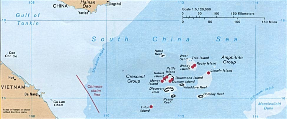
Amphitrite group
The Amphitrite group was named after the French frigate Amphitrite, which observed the islands while carrying a Jesuit mission to Canton in 1698–1700.{{cite book | author = J. B. Nicolas-Denis d'Apres de Mannevillett | author-link=:fr:Jean-Baptiste d'Après de Mannevillette
Lying in the northeast of the Paracel Islands at , the group consists of low, narrow islands with sand cays and enclosed shallow lagoons connected by reefs of rock. It is about 37 km northwest of Lincoln Island. The group approximately forms an ellipse with a north–south axis of 22 km.
The northern section of the group comprises West Sand, Tree Island, and the Qilian Yu (七连屿, "seven sisters") sub-group: North Island, Middle Island, South Island, North Sand, Middle Sand, South Sand, and two small sands (New West Sand and New East Sand). The center of the group consists of Woody Island and Rocky Island, approximately 5 km south of the southern tip of the eastern extremity of the northern section. The southwest corner of the group is occupied by the Iltis Bank.
The largest island of the Paracels, Woody Island (which has an area of 213 ha), has over 1,000 residents including fishermen and their families, military personnel, and civilian administrators.
Crescent group

Lying about 70 km southwest of the Amphitrite group, at , the Crescent group consists of islands and reefs that form a crescent-like structure from west to east, enclosing a deep central lagoon. The group measures 31 by east-west and north–south. All of the islands in the group support vegetation except on their small cays.
The islands are named after former senior figures in the British East India Company (EIC). Three were members of the EIC's 'Select Committee' in Canton: James Drummond, Thomas Pattle and John William Roberts. Jonathan Duncan was Governor in Council of Bombay, and William Taylor Money was Superintendent of the Bombay Marine.
Money Island lies at the southwest extremity of the group, and has some small cays on the southern side. While the island's English name was named after William Taylor Money, the Chinese name is Jin Yin Dao, a literal translation of "money island".
Antelope Reef, submerged at high tide and containing a central lagoon, lies 2.4 km east of Money Island.
Northeast of this are Robert Island (also named Round Island) and Pattle Island, separated from each other by a 3.5 km wide deep channel. A weather station was built on Pattle Island (by the French) in 1932, and a lighthouse and radio station in 1937.
Northeast of this is Quanfu Dao ("All Wealth Island").
Observation Bank, also named Silver Islet, and the Lesser Silver Islet, are the northernmost of the group and contain a small cay.
Just south of them are Yagong Dao (He Duck) and Xianshe Yu (Salty Hut).
At the eastern side of the group lies a 12 km long boomerang shaped reef with Stone Islet at its north end and Drummond Island at its south end. Near the centre of the reef is Dragon Hole the second deepest known sinkhole in the world.
The Duncan Islands (), consisting of Duncan Island and Palm Island, lie approximately 3 km west of Drummond Island and about 8 km east of Antelope Reef. Kuangzai Shazhou (Little Basket) lies about halfway between Palm Island and Antelope Reef.
Other features
Taking as the center of the Paracel Islands, then the Amphitrite Group is ENE, and the Crescent Group is West.
Southeast
- Bombay Reef: This elongated reef is situated at the southeastern corner of the Paracel Islands () and lies approximately 90 km southeast of the Crescent group. With most parts submerged, the reef measures approximately 18 by (E-W by N-S). Bombay Reef encloses a deep lagoon with rocks on its edge.
Eastern sub-group
- Bremen Bank: Located 24 km north of Bombay Reef (), is the southwesternmost feature of this subgroup. This submerged shallow bank measures approximately 23 km in length from northeast to southwest. The shallowest area reaches a depth of about 12 m and is located in the southwestern part of the bank.
- Jehangire Bank: East of the Bremen Bank at
- Neptuna Bank: North of the Bremen Bank at
- Pyramid Rock: NE of the Neptuna Bank at
- Lincoln Island: Surrounded by a coral reef, located 37 km southeast from the Amphitrite Group at , the island is covered with brushes and fairly high trees, including coconut palm trees. The depth increases sharply on the northern and eastern sides of the island but the southern and south western regions are shallow. An observation post on the western side was found by officers of the German government surveys in 1883. In 1948, Great Britain requested France for permission to use the feature for military exercises.
Northeast
- Dido Bank: Separate from, and NE of, the Eastern sub-group at
(ENE: Amphitrite group)
| English name | Chinese name | Vietnamese name | Coordinates | Area | ||||||
|---|---|---|---|---|---|---|---|---|---|---|
| (ha) | Height | |||||||||
| (m) | Location / notes | Amphitrite group | Crescent group | Eastern sub-group | Other features | |||||
| Xuande Qundao (宣德群島) | Nhóm An Vĩnh | ENE | ||||||||
| Woody Island | Yongxing Dao (永興島) | Đảo Phú Lâm | 210 | ? | Center of Amphitrite group | |||||
| Rocky Island | Shidao (石島) | Đảo Đá | 8 | 14 | Connected to (NE of) Woody Is. | |||||
| West Sand | Xisha Zhou (西沙洲) | Cồn Cát Tây | 4 | 0 | NW of Amphitrite group | |||||
| Tree Island | Zhaoshudao (趙述島) | Đảo Cây | 22 | 0 | N of Amphitrite group | |||||
| ("Seven Sisters") | Qilian Yu Subgroup (七連嶼) | NE of Amphitrite Group | ||||||||
| North Island | Bei Dao (北島) | Đảo Bắc | 4 | 0 | N1 of Seven Islets | |||||
| Middle Island | Zhong Dao (中島) | Đảo Trung | 13 | 0 | N2 of Seven Islets | |||||
| South Island | Nan Dao (南島) | Đảo Nam | 17 | 0 | N3 of Seven Islets | |||||
| North Sand | Bei Shazhou (北沙洲) | Cồn Cát Bắc | 2 | 0 | N4 of Seven Islets | |||||
| Middle Sand | Zhong Shazhou (中沙洲) | Cồn Cát Trung | 5 | 0 | N5 of Seven Islets | |||||
| South Sand | Nan Shazhou (南沙洲) | Cồn Cát Nam | 6 | 0 | N6 of Seven Islets | |||||
| (New West Sand) | Xixin Shazhou (西新沙洲) | - | 0.2 | 0 | N7a of Seven Islets (7W) | |||||
| (New East Sand) | Dongxin Shazhou (东新沙洲) | - | 0.4 | 0 | N7b of Seven Islets (7E); South of South Sand | |||||
| Iltis Bank | Yin Shuo Tan (銀铄滩) | Bãi Bình Sơn | -10 | SW of Woody Island | ||||||
| Yongle Qundao (永樂群島) | Nhóm Lưỡi Liềm | |||||||||
| Money Island | Jinyin Dao (金銀島) | Đảo Quang Ảnh | 36 | 6 | W end of Crescent group | |||||
| Antelope Reef | Lingyang Jiao (羚羊礁) | Đá Hải Sâm | 0 | W Crescent Group, S of Robert Is. | ||||||
| Robert Island | ||||||||||
| (Round Island) | Ganquan Dao (甘泉島) | Đảo Hữu Nhật | 30 | 8 | W of Crescent group; Has a well | |||||
| Pattle Island | Shanhu Dao (珊瑚島) | Đảo Hoàng Sa | 31 | 9 | N of Robert Island Has a well | |||||
| (East Shanhu Shoal) | Shanhu Dong'ansha (珊瑚东暗沙) | Bãi Đèn Pha | 0 | E of Pattle Island | ||||||
| (All Wealth) | Quanfu Dao (全富島) | Đảo Ốc Hoa | 2 | 0 | NE of Pattle, SW of Observation Bank | |||||
| Observation Bank | ||||||||||
| (Silver Islet) | Yin Yu (銀嶼) | Bãi Xà Cừ | 1 | 0 | NE of Crescent group | |||||
| (Lesser Silver Islet) | Yinyu Zi (銀嶼仔) | Bãi Tiểu Xà Cừ | 0.2 | 0 | SE of Silver Islet | |||||
| (He Duck) | Yagong Dao (鴨公島) | Đảo Ba Ba | 1 | 0 | SW of Observation Bank | |||||
| (Salty Hut) | Xianshe Yu (咸舍嶼) | (Đá Trà Tây?) | 0 | SW of Observation Bank, W of Stone Islet | ||||||
| (Stone Islet) | Shi Yu (石嶼) | (Đảo Lưỡi Liềm?) | 0.2 | 0 | E of Crescent group | |||||
| Drummond Island | Jinqing Dao (晉卿島) | Đảo Duy Mộng | 21 | 3 | E of Crescent group | |||||
| Duncan Island | Chenhang Dao (琛航島) | Đảo Quang Hòa | 48 | ? | S of Crescent group | |||||
| Palm Island | Guangjin Dao (廣金島) | Đảo Quang Hòa Tây | 6 | ? | S of Crescent group | |||||
| (Little Basket) | Kuangzai Shazhou (筐仔沙洲) | Đảo Sâm Cầm | 1 | 0 | SE of Antelope Reef | |||||
| Bremen Bank | Binmei Tan (濱湄灘) | Bãi Châu Nhai | -11 | Eastern sub-group | ||||||
| Jehangire Bank | Zhanhan Tan (湛涵灘) | Bãi Quảng Nghĩa | -12 | Eastern sub-group | ||||||
| Neptuna Bank | Beibian Lang (北邊廊) | Bãi Thuỷ Tề | -15 | Eastern sub-group | ||||||
| Pyramid Rock | Gaojian Shi (高尖石) | Hòn Tháp | 4 | 5 | Eastern sub-group | |||||
| Lincoln Island | Dong Dao (東島) | Đảo Linh Côn | 160 | 5 | Eastern sub-group | |||||
| "Water can be found on the island" | ||||||||||
| Discovery Reef | Huaguang Jiao (華光礁) | Đá Lồi | -4 | Inner SW | ||||||
| Passu Keah | Panshi Yu (盤石嶼) | Đảo Bạch Quy | 40 | 0 | Inner SW, S of Discovery Reef | |||||
| Herald Bank | Songtao Tan (嵩燾灘) | Bãi Ốc Tai Voi | -236 | ESE | ||||||
| Bombay Reef | Langhua Jiao (浪花礁) | Đá Bông Bay | 0 | SE | ||||||
| Vuladdore Reef | Yuzhuo Jiao (玉琢礁) | Đá Chim Én | 0 | Central | ||||||
| Dido Bank | Xidu Tan (西渡灘) | Bãi Gò Nổi | -23 | NE | ||||||
| North Reef | Bei Jiao (北礁) | Đá Bắc | 0 | NW | ||||||
| Triton Island | Zhongjian Dao (中建岛) | Đảo Tri Tôn | 120 | 3 | Outer SW |
Satellite images
File:Money Island (Paracel Islands) 2023-04-04.jpg|Money Island File:PattleIsland.jpg|Pattle Island File:RobertIsland.jpg|Robert Island File:AntelopeReef.jpg|Antelope Reef File:BombayReef.jpg|Bombay Reef File:BremenBank.jpg|Bremen Bank File:DiscoveryReef.jpg|Discovery Reef File:IltisBank.jpg|Iltis Bank File:LincolnIsland.jpg|Lincoln Island File:NorthReef.jpg|North Reef File:PassuKeah.jpg|Passu Keah Reef File:TritonIsland.jpg|Triton Island
Etymology
Chinese

The Chinese wrote about large groups of maritime features in the area. Names such as changsha, shitang, shichuang and others were used. The Song dynasty book Zhu Fan Zhi mentions Qianli Changsha ({{linktext|千|里|長|沙}}, lit. "Thousand-Mile Long Sands") and Wanli Shichuang ({{linktext|萬|里|石|床}} lit. "Ten-Thousand-Mile Rock Bed"). The Yuan dynasty travel book Daoyi Zhilüe describes Wanli Shitang ({{linktext|萬|里|石|塘}}, lit. "Ten-Thousand Mile Rock Pool") as comprising three veins extending from Chaozhou to Borneo, Côn Sơn Island, and Java. The History of Yuan uses the terms Qizhouyang (七洲洋, lit. "Ocean of Seven Islands") and Wanli Shitang. In the Mao Kun map depicting 15th century Ming Treasure Voyages, groups of islands were named Shitang (石塘), Wansheng Shitangyu (萬生石塘嶼), and Shixing Shitang (石星石塘). Another Ming dynasty work, Haiyu (On the Sea), uses Wanli Shitang and Wanli Changsha. Qing dynasty maps and book Hai Lu (Illustrations of the Sea) refer to islands and other features as Changsha, Shitang, and Qizhouyang. A sea chart from the Daoguang era, Yiban Lu (Particular Illustrations) by Zheng Guangzu, uses Xisha (西沙, lit. "Western Sands/Shoals" ) to refer to the Paracels. Xisha became the standard name for the Paracels in the 20th century and was used in maps published by the Republic of China in 1935 and 1947.
European
Main article: Placer (geography)
Portuguese maps from the early 16th century marked a group of ilhas allagadas (lit. "alleged islands") in the area. They were later named y as del atabalero after the atabaque hand drum, due to the concial shape assigned to the entire group. The Paracels and the Spratlys were not distinguished separately at the time. From the mid-1500s Portuguese cartographers began referring to the group as Ilhas do Pracel, although y as del atabalero was still used for some time. The word Paracel is likely a variant of pracel or parcel, from the Spanish word placer used by Portuguese and Spanish navigators to designate shallow sandy seas or submerged banks, such as the Placer de los Roques. Similar names entered Dutch and French maps, such as the 1617 Chart of Asia and eight city maps published by Willem Blaeu as well as the 1747 Kaart van de Kusten van Kochinchine, van Tunquin, en Gedeeltelyk van de Chineesse-kus / Carte des Costes de Cochin chine, Tunquin, et Partie de celles de la Chine (lit. "Map of the coasts of Cochinchina, Tonkin, and part of the Chinese coast") published by Pieter de Hondt/Pierre d'Hondt.[[File: ThienNamTuChiLoDo BaiCatVang 1741 reproduced Dumoutier.jpg|thumb|The 1634 Route through Quảng Nam map depicting Bãi Cát Vàng–the Golden Sandbank|234x234px]]Before the 19th century, the area was primarily known only as "dangerous grounds" in English sources. In the late 1700s and early 1800s, greater attention was paid to mapping the islands in detail, notably by hydrographers such as Alexander Dalrymple and James Horsburgh, the latter of whom concluded that most of the Paracel islands indicated in earlier European maps were mistakes of sailors who really saw the tops of coastal mountains. A better picture of the area emerged in British charts by the mid-1800s.
Philippine
Due to confusion, the Spratly Islands were referred to as the Paracels in the mid-1900s.
Vietnamese
The Vietnamese call the islands Hoang Sa, (黃沙, lit. Yellow Sands), and this name is found in Vietnamese documents dating back to 1483 and An Nam quốc họa đồ published in 1490. In the modern language system, it is written as Hoàng Sa or Cát Vàng. They all have the same meaning—the Yellow Sands or the Yellow Sandbank. Before the early 19th century, the Spratly Islands to the south were considered as part of the Hoàng Sa. It was not until the reign of Emperor Minh Mạng (1820–1841) that the Spratlys were distinctly designated as Vạn Lý Trường Sa (萬里長沙, lit. Ten-Thousand-Mile Long Sands).
Infrastructure and natural resources
Infrastructure
China has historically had a presence in the islands and, as of 2016, was engaged in major infrastructure development to support its territorial claims over the archipelago, and as a result there has been, and continues to be, a lot of construction activity. In recent years Woody Island has acquired an upgraded airport, an upgraded sea port, and a city hall. There is a post office, hospital and a school on Woody Island.
Fresh water
There is limited supply of fresh water on the islands. In 2012, it was reported that China (PRC) planned to build a solar-energy-powered desalination plant on the islands. In 2016, it was reported that the first desalination plant was activated. This reduces the occupant's reliance on water supply coming in barrels by boat.
Electricity
Both wind and solar powered facilities exist, but most of the electricity is supplied by diesel generators. This led to considerations by the Chinese government to use floating nuclear power plants. It was reported in October 2020 that an experimental wave power generator was installed off Woody Island.
On land, in August 2020, Millennium Energy Viêtnam Co., Ltd, a member of Millennium Petroleum Corporation announced plans to develop a 600 ha, US$15 billion LNG project in the south Vân Phong area of the Khánh Hòa province, i.e. Nha Trang, near by Cam Ranh, with capacity of 9,600 MW, project which include a dock warehouse system, may be terminals, to provide gas to the power plant as well as distribute LNG in South-East Asia, supplied presumably by the offshore gas deposit along the coast of Quảng Nam province, discovered by ExxonMobil in October 2011, at 200 nautical miles (roughly 370 km), amid the area disputed by China (PRC), surrounded the Paracel Islands, in Chinese maritime border sovereignty claimed by Beijing (refer to "Battle of the Paracel Islands"). Trung Nam Group also announced in early April 2021, a wind power 900 ha complex US$174 million with capacity of 423 GW/h/year, directly connected to the country's grid through Tháp Chàm 220 kV transformer station.
Communication
The Chinese postal zip code of the island is 572000, and the telephone area code is +86 (898). There is cellphone reception on the island.
Transport
There is an airport on Woody Island with a 2400 m long runway, which can handle take-offs and landings of Boeing-737s or planes of similar size. Flight services operate on the Haikou – Xisha route. There are three main roads on Woody Island as well as an 800 m long cement causeway that connects Woody Island and Rocky Island. Extensive port facilities have been constructed on Duncan Island.

Ecology and tourism
Paracel Islands' geographical and ecological traits are often likened as "China's Maldives", however, controversial conflicts between environment conservation and human activities including military operations, developments, and tourism on Paracel Islands have become public concerns in recent years. Local ecosystem include endangered fish such as whale sharks, oceanic birds, marine mammals (at least historically) such as blue whales, fin whales, and Chinese white dolphins, and marine reptile species such as critically endangered green sea turtles, hawksbill sea turtles, and Leatherback sea turtles; however, direct damaging of the ecosystem by military group and tourists has been documented. Governmental actions to cease illegal tourism are ongoing.
The islands have been open for tourists since 1997. Chinese tourists can take a 20-hour ferry to the Islands, paying up to US$2,000 for a 5-day cruise, and are placed on a long waitlist before being accepted. The BBC article states that "Chinese tourism has strong political implications, as the Chinese tourists are being used as 'foot soldiers of China' by Beijing to further China's territorial claims there". The video also states "Vietnam is considered unlikely to send military vessels to stop them".
There are two museums on Woody Island; a Naval Museum and a Maritime Museum. In April 2012, the Vice-Mayor and officials from the Haikou Municipal Government made several announcements about developing new docking facilities and hotels within the Crescent Group - on Duncan and Drummond Islands specifically. Promotion of the naturally unspoilt reef system was cited as the driver for new tourism potential with other such reefs, such as the Great Barrier Reef in Australia, now placed under threat of extinction due to human activities. However, according to The China Post, this was denied by a PRC Government official in April 2012, due to sensitivities surrounding the islands.
Territorial disputes
Main article: Territorial disputes in the South China Sea
Claims
The ownership of the islands remains hotly contested. The People's Republic of China (PRC) on mainland China, Vietnam, and the Republic of China (ROC) on Taiwan all claim sovereignty. The PRC has controlled the entire archipelago since the Battle of the Paracel Islands in January 1974. In July 2012, China (PRC) established Sansha, Hainan Province, as administering the area. As of February 2017, 20 PRC outposts, including small harbours, built on reclaimed land have been reported in the Paracels. The majority of the Paracel islands lie within 200 nm of both China's and Vietnam's geographic baselines under the United Nations Convention on the Law of the Sea.
Historical perspectives
The nation states involved have differing historic perspectives as to sovereignty of the Paracel Islands with the Chinese claiming an interest since their discovery of the islands in the second century BC. A Vietnamese interest was crystallised in the view of one commentator by the planting of their flag in 1816. In 1836, the Vietnamese installed ten 5-meter steles with inscriptions that claimed the islands.
Between 1881 and 1883 the German navy surveyed the islands continuously for three months each year without seeking the permission of either France or China. No protest was issued by either government and the German government published the results of the survey in 1885. After the 1884–1885 Sino-French War, France officially gained control of Annam and Tonkin as protectorates and fully established French colonial rule in Vietnam by signing a number of treaties with the Chinese and Vietnamese governments, including the Tientsin Accord, Treaty of Huế (1884) and Treaty of Tientsin (1885), stipulating that China was to give up their claims of suzerainty over Vietnam.
In 1909 the Chinese sent an expedition to claim and map the islands in reaction to Japanese interest in exploiting the guano there.{{cite web
In 1932 France formally claimed the Paracel Islands and in 1933 the Spratly Islands. Initially there seems to have been confusion in China at the time as the Paracel Islands were not recognised as a separate geographical entity and formal protests did not immediately follow. China and Japan both protested. In 1933, France seized the Paracels and Spratlys, announced their annexation, formally included them in French Indochina, and built a couple of weather stations on them, but did not disturb the numerous Chinese fishermen it found there. In 1939 during the Second Sino-Japanese War, Japan took over the Paracel Islands on the pretext of them being a Chinese territory and placed them under the administration of either Taiwan or Hainan, then under its control.
The Paracels and Spratlys were handed over to the Republic of China's control after the 1945 surrender of Japan, since the Allied powers had assigned the Republic of China to accept the Japanese surrender in the area. At the end of the war (Asian-Pacific Region), the ROC occupied the Paracels, Spratlys, and other islands in the South China Sea in October and November 1946. During the San Francisco Peace Conference of 1951, the USSR motioned for the Paracels and the Spratlys to be awarded to China, but the motion was rejected by a vote of 46 to 3. In the Geneva accord of 1954, Japan formally renounced all of its claims to, inter alia, the South China Sea islands that it had occupied during World War II. After World War II ended, the Republic of China was consistently the "most active claimant" of the islands. It garrisoned Woody Island, the main island of the Amphitrite group, and posted Chinese flags and markers on it. France tried, but failed, to force the ROC to leave, although the weather station on Prattle Island continued to be operated by French Indochina. The aim of the ROC was to block French claims. In December 1947, the ROC drew up a map showing its eleven-dotted line U-shaped claim to the entire South China Sea, including the Spratly and Paracel Islands as Chinese territory.
After the communists gained control of China in 1949 after victory in the Chinese Civil War, they occupied Woody Island. By 1955 South Vietnam had taken possession of the Crescent Group. North Vietnam's prime minister Phạm Văn Đồng recognized Chinese sovereignty over the Paracels in 1958. After winning the Vietnam war, North Vietnam retracted its recognition, saying it had done so to receive aid from China in fighting the Americans, according to Pham's discussion in June 1977 with China's Li Xiannan.
After the Battle of the Paracel Islands in January 1974, the People's Republic of China expelled the Vietnamese from the Crescent Group and took full control of the Paracels. In 1976 the Communist Party of Vietnam (CPV) tried to persuade Beijing to acknowledge Vietnam's sovereignty over the Spratly Islands to the south, offering in return to recognize China's claim over the Paracel Islands. However, when this effort failed, Vietnam's government, now under CPV control, asserted its claim over both archipelagos.
China
618–1279
There are some Chinese cultural relics in the Paracel islands dating from the Tang and Song eras, and there is some evidence of Chinese habitation on the islands during these periods, though the relics are more likely washed ashore from shipwrecked junks. According to the Wujing Zongyao, a book published in the Northern Song dynasty in 1044, the Song government then included the Islands in the patrol areas of the Navy of the Court.
1279–1368
The Yuan dynasty travel book Daoyi Zhilüe describes Wanli Shitang ({{linktext|萬|里|石|塘}}, lit. "Ten-Thousand Mile Rock Pool") as comprising three veins extending from Chaozhou to Borneo, Côn Sơn Island, and Java. In 1279 the Yuan emperor sent the high-level official and astronomer, Guo Shoujing, to the South China Sea to survey and measure the islands and the surrounding sea area. Guo's base of survey was claimed by China to be located in the Paracel Islands, although this is considered unlikely by many Chinese scholars. His activities were recorded in the Yuan Shi, or History of Yuan. According to the Yuan Shi, the South China Sea islands were within the boundary of the Yuan dynasty. Maps published in the Yuan era invariably included the Changsha (the Paracels) and the Shitang (the Spratlys) within the domain of Yuan.
1368–1912
Relevant local annals and other historic materials of the Ming (1368–1644) and the Qing (1644–1912) dynasties continued to make reference to the South China Sea islands as China's territory. The Qiongzhou Prefecture (the highest administrative authority in Hainan), exercised jurisdiction over the Paracel and Spratly Islands in the Ming and Qing Dynasties.
In the 19th century, Europeans found that Chinese fishermen from Hainan annually sojourned on the Paracel and Spratly Islands for part of the year. For three months each year between 1881 and 1884, the German Imperial Navy sent two boats (the ship Freya and the warship Iltis) to study and map the Paracel Islands without either seeking the permission of or incurring protest by the Chinese government. This mission was finished without any problems and the German Admiralty published the results in 1885 in a document called "Die Paracel-Inseln" (The Paracel Islands). In the period 1884 to 1885 the Tientsin Accord and Treaty of Tientsin were signed by Chinese representatives to attempt to address issues from an undeclared war between France acting on behalf of its protectorate territories in Vietnam and China. During this period between the treaties the Chinese did claim the Paracels. In 1909, Zhang Renjun (), the Viceroy of Liangguang, ordered Guangdong Fleet Admiral Li Zhun (李準) to sail to the Paracel Islands. In June, with over 170 sailors in three warships named Fubo (伏波號), Guangjin (廣金號) and Shenhang (琛航號), he inspected 15 islands, erected stone tablets engraved with each island's name, raised China's flag and fired cannons to declare the islands "sacred territory of China", which France did not protest. In 1910, the Qing government decided to invite Chinese merchants to contract for the administration of the development affairs of the South China Sea islands, and demanded that officials shall provide protection and maintenance in order to highlight Chinese territory and protect its titles and interests.
1912–1950s
After the fall of the Qing dynasty, the new Government of Guangdong Province decided to place the Paracel Islands under the jurisdiction of the Ya Xian County of Hainan Prefecture in 1911. The Southern Military Government in 1921 reaffirmed the 1911 decision. China continued to exercise authority over the South China Sea islands by such means as granting licenses or contracts to private Chinese merchants for the development and exploitation of guano and other resources on those islands and protesting against foreign nations' claims, occupations, and other activities. For example, in May 1928, the Guangdong provincial government sent a naval vessel, the Hai-jui (海瑞號), with an investigation team organized by the provincial government and Sun Yat-Sen University to investigate and survey the islets, after which the investigation team produced a detailed Report of Surveys on the Paracel Islands.
On July27, 1932, the Chinese Foreign Ministry instructed the Chinese Envoy to France to lodge a diplomatic protest to the French Foreign Ministry and to deny France's claims to the Paracel Islands. On November 30 of the same year, Zhu Zhaoshen, a high-level inspection official of the Chinese Foreign Ministry, issued public correspondence Number 66 to the French Consul in Guangzhou, reiterating that "it is absolutely beyond doubt that the Xisha [Paracel] Islands fall within the boundary of China". Despite repeated Chinese protests, French troops, who had colonized French Indochina in the 19th century, invaded and occupied the Paracel Islands on July 3, 1938. This took place shortly after the breakout of the Second Sino-Japanese War, when the armed forces of China and Japan were busy elsewhere. Three days later, on July 6, the Japanese Foreign Ministry also issued a declaration in protest of the French occupation
During the Second World War, the Japanese expelled the French troops and took over the islands in spite of the 1938 declarations. The Spratlys and the Paracels were conquered by Japan in 1939. Japan administered the Spratlys via Taiwan's jurisdiction and the Paracels via Hainan's jurisdiction. The Paracels and Spratlys were handed over to Republic of China control after the 1945 surrender of Japan, since the Allied powers had assigned the Republic of China to receive Japanese surrenders in that area. At the end of the war (Asian-Pacific Region), Nationalist China formally retook the Paracels, Spratlys and other islands in the South China Sea in October and November 1946. In the Geneva accord of 1954 Japan formally renounced all of its claims to, inter alia, the South China Sea islands which it had occupied during the World War II. After WW2 ended, the Republic of China was the "most active claimant". The Republic of China then garrisoned Woody Island in the Paracels in 1946 and posted Chinese flags and markers on it; France tried, but failed, to make them leave Woody island. The aim of the Republic of China was to block the French claims. In December 1947, the Republic of China drew up a map showing its eleven-dotted line U-shaped claim to the entire South China Sea, including the Spratly and Paracel Islands as Chinese territory.
Vietnam
15th–17th centuries

- 1460–1497, under the reign of Emperor Lê Thánh Tông of the Lê dynasty (1428–1789), the Vietnamese began conducting commercial activities on and around Hoàng Sa, including harvesting abundant sea-products and conducting salvage operations on shipwrecks.
- In 1634, during year fifth of Emperor Đức Long of Vietnam (1629–1635), the ship Grootebroek of the Dutch East India Company sank in the vicinity of the Paracel archipelago. Using a small boat, captain Huijch Jansen and 12 sailors managed to reach Đàng Trong, territory of Lord Nguyễn Phúc Nguyên (1613–1635), to seek rescue for other castaways still on the islands.
- 1680–1705, Lord Trịnh Căn of Tonkin instructed Đỗ Bá Công Đạo to publish Thiên Nam tứ chí lộ đồ (天南四至路圖), an encyclopedia consisting of four series of maps that detail routes from Thăng Long, capital of Đại Việt, to other countries in Southeast Asia. Part of this work was based on the Hồng Đức Atlas (Hồng Đức Bản Đồ) developed during the time of Emperor Lê Thánh Tông (1460–1497). This encyclopedia was considered one of the oldest and rarely preserved Vietnamese documents regarding the islands. The volume "Đường từ phủ Phụng Thiên đến Chiêm Thành" (The Route to Champa from Phụng Thiên Province), remarkably described the archipelago with maps. For instance, a statement found in the volume read "In the middle of the sea, there is a long sandbank called Bãi Cát Vàng, which is approximately 400-league long and 20-league wide rising up above the sea." Bãi Cát Vàng means Hoàng Sa, Golden Sandbank.
- In the 18th century, under instructions of the Nguyễn lords, the salvage operations officially started with the formation of Hoàng Sa and Bắc Hải Companies. Their responsibility was to carry out the mission at Hoàng Sa (Golden Sandbank) and Vạn Lý Trường Sa (Ten-thousand-league Long Sandbank) respectively. This effort was continued thereafter with successive establishments of other naval task units in accordance with strategic policies toward the two archipelagos under the Nguyễn dynasty. Noticeably, a number of naval battles between the Dutch fleet and the Nguyễn Royal Navy occurred in 1643 and 1644. The Hoàng Sa naval task unit consisted of 70 men recruited from An Vĩnh and An Hải villages of Quảng Ngãi, while the majority of members of the Bắc Hải Company came from Bình Thuận province.
1700–1799
- In 1776, the Phủ Biên Tạp Lục (撫邊雜錄), the Miscellaneous Records on the Pacification of the Frontiers, published by Lê Quý Đôn, a philosopher, an encyclopedist, and a Minister of Construction during the Lê dynasty (1428–1789). These six volumes detail the Nguyễn dynasty's territories, including the exploitation of the Paracel and Spratly Islands from 1702 onwards.
- 1777–1784, when traveling to Cochinchina, Father Jean-Baptiste Grosier recorded his impression about maritime activities of the Vietnamese from Huế, Đà Nẵng, and Quảng Ngãi. The abbot Grosier wrote that the people from those ports were excellent and cleverest navigators in this Kingdom. One of their activities was making long-distance sailing every year to the long chain of islands and rocks known as the Paracels to collect debris from shipwrecks.
1800–1899
- 1802–1820, under the reign of Emperor Gia Long, the territory of his kingdom included Tonkin, Cochin China, part of Cambodia, and "certain islands off the coast including the well known Paracels which bear such an evil reputation as a source of danger to navigation in the China Seas." In 1802, Emperor Gia Long created the "Hoàng Sa Đội" (Company of the Paracels) to supervise the island exploitation.
- In 1807, the East India Company sent Captain Daniel Ross to Cochinchina to survey the Paracel Islands. Upon arriving to the kingdom, he presented a letter of introduction entrusted by the English company to the reigning king, who was believed to be Emperor Gia Long at that time. Subsequently, Captain Ross completed chartering the south coast of China in 1807, the Paracel Islands in 1808, part of the coast of Cochin China in 1809, and the coast of Palawan in 1810. Most notably, in his surveys published in 1821 under the title "(South) China Sea, Sheet I & II", the Spratly Islands was referred to as The Dangerous Ground and was later renamed as Storm Island on the 1859 edition of the chart. Separately, in another document, the "Correct Chart of the China Sea", published by Herbert in 1758, the Paracel archipelago was described as a long group of islands and reefs extending from 13 to 17 degrees North, which approximately correspond to the geographic latitudes of the present-day Spratly and Paracel Islands, respectively. It is quite clearly that the captain himself, and probably most navigators of his time, did not differentiate the two archipelagos, but instead had delineated the present-day Spratly Islands as part of the Paracels. Captain Daniel Ross was a well known hydrographer of the Navy of Government of English Bengal and founder of the Bombay Geographical Society.
- In 1815, Emperor Gia Long ordered Phạm Quang Anh's Hoàng Sa naval task unit to sail to the islands to make surveys and report on maritime routes and draw up maps.
- In 1816, according to Jean-Baptiste Chaigneau, Emperor Gia Long officially claimed the sovereignty of the Paracel Islands, which would include the present-day Spratly archipelago. These two islands were later delineated distinctly under the reign of his successor, Emperor Minh Mạng. Chaigneau was one of the most respected advisors to Emperor Gia Long. He spent more than 30 years in Cochinchina and became the first French Consul to this kingdom in 1821.
- In 1821, the Lịch triều hiến chương loại chí (歷朝憲章類誌) published by Phan Huy Chú, a historian, an encyclopedist, and an officer of the Ministry of Construction in the time of emperor Minh Mạng. This remarkable work was prepared in 10 years (1809–1819) and consisted of 10 volumes. One of them, the Địa Dư Chí volume, details territories of Dai Nam Kingdom. In 1838, he published the Đại Nam Thống Nhất Toàn Đồ, the Unified Đại Nam Complete Map, that distinctly delineated Vạn Lý Trường Sa (the Ten-thousand-league Long Sandbank) and Hoàng Sa (the Golden Sandbank).
- In 1827, a world atlas produced by Belgian geographer Philippe Vandermaelen was published in Belgium. Vietnam was described by four maps in this atlas. One of these maps has the title "Partie de la Cochinchine", in which Paracel Islands was included, indicating that it was part of Cochinchine (southern Vietnam region). The map also featured geography, politics, minerals and statistics about the Empire of An Nam (former name of Vietnam). Moreover, the map titled "Partie de la Chine" in the atlas had identified Hainan Island as the southernmost point of China at that time.
- In 1833, Emperor Minh Mạng ordered the Ministry of Construction to build a temple, erect steles, and plant many trees on the islands for navigation purposes.
- In 1834, Emperor Minh Mạng ordered Trương Phúc Sĩ, a naval task unit commander, accompanied by 21 men sailing to the islands to survey and draw map of Hoàng Sa.
- In 1835, Emperor Minh Mạng issued a royal ordinance to order 24 troops to the Paracel Islands. Generations of the Đặng family have preserved the royal ordinance and publicly disclosed it in early 2009.
- In 1835, the King ordered Phạm Văn Nguyên's naval task unit, accompanied by workers from Bình Định and Quãng Ngãi provinces, to build Hoàng Sa temple with a wind screen and erect steles on Bàn Than Thạch (Bàn Than Rock) of the present-day Woody Island. The mission was completed in 10 days. Notably, about 33m southwest from the erection, there was a little ancient temple where a stele engraved with the words "Vạn Lý Ba Bình" found. This inscription means Ten Thousand Leagues of Calming Waves. The date of the actual erection of the ancient temple remains unknown
- In 1836, Emperor Minh Mạng received a report from his Ministry of Construction that recommended a comprehensive survey of all the East Sea islands because of their "great strategic importance to our maritime borders." The King ordered Phạm Hữu Nhật, a royal navy commander, to erect a wooden stele on the islands. The post was engraved with the following inscription: The 17th of the reign of Minh Mạng by the royal ordinance commander of the navy Phạm Hữu Nhật came here to Hoàng Sa for reconnaissance to make topographical measurements and leave this stele as record thereof.
- In 1838, Bishop Jean-Louis Taberd published the "Latin-Annamese Dictionary". The dictionary contains the "An Nam Đại Quốc Họa Đồ" (The Great Annam Map). In the neighborhood of the present-day coordinate of the islands, words found on the map read "Paracel seu Cát Vàng" (Paracel or Cát Vàng). Cát Vàng means Hoàng Sa, Golden Sands or Golden Sandbank.
- In 1842, Hai Lu Do Chi, a historical Chinese document was written in the 22nd year of the reign of the Daoguang Emperor (1820–1850) of the Qing dynasty (1644 to 1912) of China. A statement found in this book read: Wang Li Shi Tang (万里石塘) is a sandbank rising above the sea. Several thousand leagues in length, it forms a rampart on the periphery of the Kingdom of Annam. Wang Li Shi Tang means Ten-thousand-league Long Sandbank.
- In 1858, Napoleon III ordered French troops to attack Tourane, the present-day Đà Nẳng city. Subsequently, France launched more attacks and forced Cochin China and some provinces in the South to become her colonies. French Indochina was formed in 1887 and consisted of Tonkin, Annam, Cochin China, and Cambodia.
- The 1887 Chinese-Vietnamese Boundary Convention signed between France and China after the Sino-French War, which, according to China, put the islands in the Chinese territory. In fact, the treaty only clarified Gulf of Tonkin sea border and other land border issues between Vietnam and China.
- 1895–1896, German vessel Bellona and Japanese ship Himeji Maru sank at the islands. Chinese fishermen looted and resold them at Hainan. These countries protested but local Chinese authorities, the Governor of Liang Guang, denied any responsibilities on the ground that the Paracels were abandoned and belonged to neither country.
File:MinhMang royal ordinance 1.jpg|The Royal Ordinance issued by Emperor Minh Mạng, 1835 File:HoangSa.jpg|Đại Nam Thống Nhất Toàn Đồ—The Unified Đại Nam Complete Map (1838)—distinctly delineated Hoàng Sa and Vạn Lý Trường Sa at the far right margin File:Paracels.JPG|1880 German map of Southeast Asia, locating the Paracel Islands as part of "Annam" (Vietnam) File:Nam-Triều Quốc-Ngữ Công-Báo (南朝國語公報) số 8 (1938) - Dân Làm Báo.jpg|Imperial edict no. 10 of 29-02-Bảo Đại 13 (30 March 1938) transferring the Paracels from the Quảng Ngãi province to the Thừa Thiên province issued by the Bảo Đại Emperor as recorded in the Nam-Triều Quốc-Ngữ Công-Báo (南朝國語公報, "Bulletin of the Southern dynasty in the National Language") số 8 (1938). Referring to the islands as "sovereign" (chủ-quyền) territory of the South (nước Nam) since "long ago and under previous dynasties" (đã lâu đời và dưới các tiền triều). File:SacLuat-HoangSa.jpg|Decree no.174-NV from the presidency of Ngô Đình Diệm, Republic of Vietnam, redistricting the Paracels as part of Quảng Nam Province effective 13 July 1961. The Paracels were previously part of Thừa Thiên–Huế Province since 30 March 1938, when redistricted by the government of French Indochina.
20th-century events
- In the 1910-20s, the French Ministry of Colonies and the Ministry of Foreign Affairs agreed that the Paracel Islands were under Chinese sovereignty, and that France should not try to claim them, either on behalf of itself, or Annam. Therefore, France did not protest in 1921 when the government of Guangdong province declared the Paracels to be under the administration of Hainan Island. 5 years later in 1926, France refused an application from a French company to exploit guano in the Paracels. It also refused a similar application from a Japanese company.
- In 1932, France nonetheless formally claimed both the Paracel and Spratly Islands. China and Japan both protested. On 6 April 1933, France occupied the Spratlys, announced their annexation, formally included them in French Indochina, and built a couple of weather stations on them.
- On 3 July 1938, French Indochinese colonial troops, headed by sub-lieutenant Edmond Grethen, occupy the Paracels islands in turn.
- In March 1939 Japan took the islands from France, garrisoned them, and built a submarine base at Itu Aba (now Taiping / 太平) Island. In 1941, the Japanese Empire made the Paracel and Spratly islands part of Taiwan, then under its rule.
- After World War II, Nationalist China reaffirmed its sovereignty over the islands in the South China Sea, and dispatched a patrol force to the islands, but this was challenged by the French.
- After the fall of the nationalist regime in China in 1949, the PRC gained control of the eastern half of the Paracel islands. Several small clashes occurred between the French and the communist Chinese naval forces during this period, but eventually a de facto line of control was established with the PRC occupying Woody Island, while the remainder was held by Franco -Vietnamese forces.
- In 1951, at the international Treaty of San Francisco conference, Vietnam's representative claimed that both the Paracels and Spratlys are territories of Vietnam, and was met with no challenge from all nations at the event.
- In 1954, according to the Geneva Agreements, which were signed by a number of nations including the PRC, Vietnam was partitioned into two states, North Vietnam and South Vietnam. The 17th parallel was used as the provisional military demarcation line, which was effectively extended into the territorial waters.
- In 1956, after the French withdrawal from Vietnam, South Vietnam replaced French control of the islands. By February 1956, the South Vietnamese Navy was already stationed on Pattle Island by Ngô Đình Diệm, though both the PRC and ROC politically and diplomatically condemned the decision and reaffirmed their claims to the islands. Following on the former French claim, Vietnam claimed the entire Paracel Islands.
- On September 4, 1958, the government of the PRC proclaimed the breadth of its territorial sea to be twelve nautical miles (22 km) which applied to all its territory, including the Paracel and Spratly Islands. Ten days later, the prime minister of North Vietnam, Phạm Văn Đồng, in his letter to Zhou Enlai stated that his government had respected the declaration of the PRC government. The PRC government used this letter as justification for their occupation, in fact, according to PhD Nguyen Van Canh: "The note of a prime minister, that is, the executive, is just an administrative document in the field of diplomacy, and in the matter of territorial transfers, the constitutions of countries stipulate that there must be a treaty regulating the transfer of territory and determine that problem. In other words, the National Assembly decides on that issue, and the National Assembly reflects the will of the entire people when transferring territory."
- [[File:HoangSa-thu-dedoc-tranvanchon.jpg|thumbnail|Letter from South Vietnam's General Staff of the Republic of Vietnam Military Forces, dated 18 February 1974, concerning the Battle of the Paracel Islands]] On January 19, 1974, the Battle of the Paracel Islands between the PRC and South Vietnam took place, leaving the PRC in control of the entire archipelago. On January 16, South Vietnamese naval officers and an American observer had reported to Saigon some suspected military activities of the Chinese navy on the Drummond and Duncan islands. After receiving the report, the government of South Vietnam decided to counter the Chinese forces, to defend the South Vietnamese-controlled section (the western half of the Paracels) from Chinese occupation, and sent a unit of frigates to the area. On January 19, there were sea and land battles between the Chinese and Vietnamese forces with casualties on both sides. At the end, the Chinese fleet defeated the naval force of South Vietnam. With the ongoing civil war with the Viet Cong embroiling South Vietnam's attention and the absence of the USA's support, no military attempt was made to re-engage the PRC over the islands. After the military engagement and the subsequent victory, the PRC gained control of the entire archipelago and has maintained control since. It was a significant turning point for the PRC but the sovereignty dispute on the islands remains unresolved with Vietnam.
- In 1982, Vietnam established Hoang Sa District in Quang Nam-Da Nang covering these islands.
- In a statement released on 13 July 1999 by the foreign ministry of Taiwan, under President Lee Teng-hui stated that "legally, historically, geographically, or in reality", all of the South China Sea and the islands were Taiwan's territory and under Taiwanese sovereignty. The ROC's and the PRC's claims "mirror" each other. Taiwan and China are largely strategically aligned on the islands issue, since they both claim exactly the same area, so Taiwan's claims are viewed as an extension of China's claims. China has urged Taiwan to cooperate and offered Taiwan a share in oil and gas resources while shutting out all the other rival claimants. Board director Chiu Yi of Taiwan's state run oil company, CPC Corp, has named Vietnam as the "greatest threat" to Taiwan. The United States has regularly ignored Taiwan's claims in the South China Sea and does not include Taiwan in any talks on dispute resolution for the area.
21st-century events
-
In July 2012 the National Assembly of Vietnam passed a law demarcating Vietnamese sea borders to include the Paracel and Spratly Islands. : :The Philippines and Vietnam promptly lodged diplomatic protests strongly opposing the establishment of the Sansha City under Chinese jurisdiction.
-
In April 2013, a representative from the Vietnamese Foreign Ministry's National Boundary Commission gave a diplomatic note to a representative of the Chinese Embassy in Hanoi demanding that China cancel its plan to bring tourists to the Paracel archipelago. Main article: Haiyang Shiyou 981 standoff
:According to reports from Chinese state media, at the beginning of May 2014, Chinese and Vietnamese naval vessels collided near the islands as Hanoi sought to prevent a Chinese oil rig from setting up in the area. On May 26, a Vietnamese fishing boat sank near the oil rig, after colliding with a Chinese vessel. As both sides imputed the blame to each other, Vietnam released a video footage in a week later, showing a Chinese vessel ramming into its ship before it sank; the Chinese said they were on the defensive while Vietnamese vessels were attacking the Chinese fishing boats.
- On May 9, 2014, Taiwan reiterated its claim to the Paracel islands, rejecting all rival claims amidst the standoff and repeating its position that all of the Paracel Islands, Spratly Islands, Macclesfield Bank and Pratas Islands belong to the Republic of China along with "their surrounding waters and respective seabed and subsoil", and that Taiwan views both Vietnam and mainland China's claims as illegitimate. This statement was released by Taiwan's Ministry of Foreign Affairs, which added – "There is no doubt that the Republic of China has sovereignty over the archipelagos and waters."
- In January 2016, photographs emerged that indicate that China is reclaiming land and expanding military facilities in the Paracels, including at Duncan Island, North Island, and Tree Island. Commentators have likened this work to the initial stages of China's large-scale construction in the Spratly Islands.
- On July 12, 2016, an arbitration under the United Nations Convention on the Law of the Sea (UNCLOS) backed the Philippines against China's claims of resources and maritime areas within the nine-dash line that exceeded its entitlements under the UNCLOS. The tribunal argued that China had not historically exercised exclusive control within, hence has "no legal basis" to claim "historic rights" over resources. The ruling was rejected by both China and Taiwan.
- In February 2017, the AMTI project under the Center for Strategic and International Studies reported that Chinese authorities had carried out land reclamation on 20 reefs, thus establishing 20 Chinese outposts so far. These include Duncan Island and Drummond Island which also have small helipads. Of these, three were capable of berthing small naval and commercial merchant ships. Vietnam had responded to this by expanding its already existing facilities on some of the Spratly islands occupied by it.
In popular culture
- The film Storm in the South China Sea () was produced in China in 1976, showing the Battle of the Paracel Islands in 1974.
- Battlefield 4, a 2013 first-person shooter video game, includes a map based on the Paracel Islands, titled "Paracel Storm".
- The television show "The Last Ship" features the crew of the USS Nathan James navigating a minefield through the islands as part of an operation to rescue some of their crew mates that had been taken captive by pirates and were being held hostage on one of the islands.
Notes
References
Citations
Sources
- (1686) Do Ba Cong Dao (translated by Buu Cam), "Toan Tap Thien Nam Tu Chí Lo Do Thu ", Hong Duc Ban Do, Saigon, 1962.
- (1776) Le Quí Don (translated by Le Xuan Giao), "Phu Bien Tap Luc", Saigon, 1972.
- (1821) Phan Huy Chu (translated by Nguyen Tho Duc), "Lich Trieu Hien Chuong Loai Chí", Saigon, 1972.
- (1837) {{cite journal | author = Rev. Jean-Louis | author-link=Jean-Louis Taberd
- (1838) {{cite journal | author = Rev. Jean-Louis | author-link=Jean-Louis Taberd
- (1849) {{cite journal | author = GUTZLAFF | title = Geography of the Cochinchinese Empire
- (1999) Vietnamese Claims to the Truong Sa Archipelago. Todd C. Kelly, August 1999.
- \
- {{cite journal|first1 =Stein|last1 =Tonnesson|title=The South China Sea in the Age of European Decline
- (2017)
- (????) Dr. Phan Van Hoang's historical and geographical analysis on Vietnam and China's claims on the Paracels – Vietnamese language link
References
- Jones, Gareth Wyn. (2002). "The Territories of the People's Republic of China". Europa Publications.
- "Paracel Islands". CIA.
- {{cite enroute. 161. 2017. 9-11
- (2024). "Application of wetPf2 Data for Investigating Characteristics of Temperature and Humidity of Air Masses over Paracel and Spratly Islands". Advances in Meteorology.
- link. (January 1, 2016 , Vol. 7, Burns and Oates, London, 1878. Retrieved 6 April 2009.)
- link. (January 1, 2016 , Revised and expanded edition. Retrieved 6 April 2009.)
- "Woody Island".
- [[Associated Press. (15 June 2014). "China begins building school on Yongxing island - that has disputed ownership with Vietnam". The Independent (UK).
- link. [[Sohu]]. (9 July 2012)
- (2024). "Recent records of thermohaline profiles and water depth in the Taam ja' Blue Hole (Chetumal Bay, Mexico)". Frontiers in Marine Science.
- (23 July 2016). "China Exclusive: South China Sea "blue hole" declared world's deepest". news.xinhuanet.com.
- (26 July 2016). "Researchers just discovered the world's deepest underwater sinkhole in the South China Sea". Washington Post.
- Pedrozo, Raul "Pete". (August 2014). "China versus Vietnam: An Analysis of the Competing Claims in the South China Sea". CNA.
- This is the maximum height, or for submerged features, the minimum depth, in metres. A height of zero indicates low sandy cays or beaches, reefs that dry at low tide, or similar. ''Source:''
- The Overall Survey of the Ocean's Shores, Appendix 1 China in Southern Island 万生石塘 annotated as the Paracel Islands by J.V.Mills, White Lotus Press {{ISBN. 974-8496-78-3
- (2015). "南海断续线内南海诸岛整体性的历史地理认识". 中国海洋大学学报.
- Jianming Shen. (1998). "Security Flashpoints: Oil, Islands, Sea Access and Military Confrontation". Brill.
- Jianming Shen. (1998). "Security Flashpoints: Oil, Islands, Sea Access and Military Confrontation". Brill.
- Jianming Shen. (1998). "Security Flashpoints: Oil, Islands, Sea Access and Military Confrontation". Brill.
- (1 December 1998). "Asian Economic and Political Issues, Volume 1". Nova Biomedical.
- "{{lang. zh. 郑和航海图" {{in lang. zh, cited in ''The Overall Survey of the Ocean's Shores'', {{abbr. App.. Appendix 1: "China in Southern Island". White Lotus Press. {{ISBN. 974-8496-78-3.
- Jianming Shen. (1998). "Security Flashpoints: Oil, Islands, Sea Access and Military Confrontation". Brill.
- Jianming Shen. (1998). "Security Flashpoints: Oil, Islands, Sea Access and Military Confrontation". Brill.
- (1 November 2014). "The South China Sea Arbitration: A Chinese Perspective". Hart Publishing.
- (26 November 2014). "Strategic Regions in 21st Century Power Politics". Cambridge Scholars Publishing.
- Ruano, Ângela. (2021-01-01). "The Paracel Islands : Tracing their Presence on Western Maps in the Sixteenth to Eighteenth Centuries". IMCoS Journal.
- (September 8, 1831). "Diccionario marítimo español, que además de las definiciones de las voces con sus equivalentes en frances, inglés e italiano, contiene tres vocabularios de estos idiomas con las correspondencias castellanas. Redactado por orden del rey nuestro señor". Madrid, Imprenta real.
- "Parcel".
- Nguyễn Đại Việt, ''Paracel and Spratly Islands on Charts and Maps made by Westerners'', {{usurped. [https://web.archive.org/web/20160305105235/http://www.nguyenthaihocfoundation.org/lichsuVN/haidotayphuong.htm Hoàng Sa và Trường Sa trên Bản đồ Tây Phương], 2009.
- link. (January 1, 2016, Published by Wordsworth Editions, 1886. Retrieved on 7-7-2014.)
- (1747). "Map of the coast of Tonquin and Cochinchina".
- (1995). "A geographical description of the Spratly Islands and an account of hydrographic surveys amongst those islands". International Boundaries Research Unit, Univ. of Durham.
- Horsburgh, James. (1805). "Memoirs: Comprising the navigation to and from China, by the China Sea, and through the various straits and channels in the Indian archipelago; also, the navigation of Bombay harbour.". C. Mercier and Co..
- "The History of the Kingdom of Colonia St John".
- Tập San Sử Địa. "Đặc Khảo Hoàng Sa và Trường Sa – A Special Research on Paracel and Spratly Islands". Geographical Digest, Vol 29., Saigon, 1974. Reproduced version..
- Saxe Bannister, [[iarchive:ajournalfirstfr00banngoog/page/n318
- Conrad Malte-Brun, [[iarchive:universalgeogra18maltgoog/page/n308
- Phan Huy Chú, The Encyclopedia ''Lịch Triều Hiến Chương Loại Chí'', 1821. Translated into modern Vietnamese from Chinese by Nguyen Tho Duc, Saigon, 1972
- Jean Louis, ''Dictionarium Anamitico-Latinum et Latino-Anamiticum'', 1838
- (2016-02-17). "What does disputed Paracel island look like?". BBC News.
- . (14 February 2025). ["Paracel Islands"](https://www.britannica.com/place/Paracel-Islands).
- (26 October 2012). "Construction tensions in the South China Sea". Asia Times.
- "South China Sea: China Activates First Desalination Plant on Woody Island".
- (2016-01-15). "China's desalination system may 'tip the balance' in South China Sea land disputes, scientists say".
- (October 8, 2020). "Wave Power: China Uses Offshore Renewable Energy for Paracels Outpost".
- "China plans to build floating nuclear plants in South China Sea". The Economic Times.
- (2021-05-02). "Vietnam Investment Review".
- China Insider, 2013, [https://www.scmp.com/news/china-insider/article/1291152/outcry-after-chinese-tourists-pictured-hunting-rare-sea-creatures#comments Outcry after Chinese tourists pictured hunting rare sea creatures in disputed Paracel Islands] {{Webarchive. link. (May 7, 2016)
- (November 2008). "论西沙群岛珊瑚礁生态系统自然保护区的建立". 热 带 地 理 – Tropical Geography.
- [http://www.worldwildlife.org/ecoregions/im0148 South China Sea, between the Philippines, Borneo, Vietnam, and China ] {{Webarchive. link. (April 18, 2016 - WWF)
- China Insider, 2015, [https://www.scmp.com/news/china/article/1699255/tourists-fishing-endangered-species-south-china-sea-prompts-crackdown China to crack down on illegal tourism in Paracel Islands] {{Webarchive. link. (May 6, 2016)
- "CIA - The World Factbook -- Paracel Islands".
- Ethirajan, Anbarasan. (March 4, 2020). "Tourists "used" in China-Vietnam Paracel Islands dispute". BBC News Newsday.
- (27 April 2012). "China approves dock project in disputed Paracel islands". BBC News (China).
- "Paracel Islands (Paracel Islands - the new Great Barrier Reef)". VisitHainan.com.au.
- (6 April 2012). "China official denies plans for Paracel Islands tourism". The China Post.
- (21 June 2012). "China sets up Sansha City to administer South China Sea islands". [[Sina Corp.
- (8 February 2017). "The Paracels: Beijing's Other South China Sea Buildup". Asia Maritime Transparency Initiative.
- (1997). "Sharing the Resources of the South China Sea". University of Hawaii Press.
- Chang, Teh-Kuang. (1991). "China's Claim of Sovereignty over Spratly and Paracel Islands: A Historical and Legal Perspective". Case Western Reserve Journal of International Law.
- (2018). "Territorial disputes in the South China Sea, Paracel Islands". Asia–Pacific Journal of Marine Science & Education.
- Chere, L.. (1988). "The Diplomacy of the Sino-French War (1883–1885): Global Complications of an Undeclared War". Notre Dame.
- (2012). "Japanese Occupation South China Sea Islands - 1937-1941".
- {{harvnb. Kivimäki. 2002
- {{harvnb. Severino. 2011
- US Department of State Publication, Record of Proceedings of the Conference for the Conclusion and Signature of the Treaty of Peace with Japan, 119, 292 (1951).
- Myron H. Nordquist, John Norton Moore, University of Virginia, "Security flashpoints: oil, islands, sea access and military confrontation", p174-185]
- {{harvnb. Kivimäki. 2002
- (2024-06-03). "Paracel Islands {{!}} Map, History, & Location {{!}} Britannica".
- "Spratly Islands - reefs, shoals, atolls, and islets, South China Sea". Encyclopædia Britannica. Archived from the original on May 20, 2015. Retrieved May 16, 2014.]
- {{harvnb. Severino. 2011
- Corr, Anders. (2018-01-15). "Great Powers, Grand Strategies: The New Game in the South China Sea". Naval Institute Press.
- {{harvnb. Kivimäki. 2002
- {{Harvnb. Morley. Nishihara. 1997
- Wang, Frances Yaping. (2024). "The Art of State Persuasion: China's Strategic Use of Media in Interstate Disputes". [[Oxford University Press]].
- "Vietnam".
- (19 January 2024). "Vietnam's Paradox: Commemorating the Battle of the Paracels".
- Museum of Guangdong Province. (October 1974). "Briefing Investigation Report of Guangdong Province Xisha Islands' Culture Relics". Culture Relics.
- Han, Zhenhua. (April 1990). "Niangniang Temple and Corallite Little Temple in Paracel and Spratly Islands". Southeast Asian Affairs.
- link. CNKI
- (1997). "International Law Rules and Historical Evidences Supporting China's Title to the South China Sea Islands". Hastings Int'l & Comp. L. Rev..
- Scheiber, Harry N.. (2015-08-25). "Science, Technology, and New Challenges to Ocean Law". BRILL.
- Raditio, Klaus Heinrich. (2018-08-25). "Understanding China’s Behaviour in the South China Sea: A Defensive Realist Perspective". Springer.
- Shao, Wenguang. (2022-12-21). "China’s Foreign Policy and Practice: A Survey". Taylor & Francis.
- {{harvnb. Kivimäki. 2002
- (2008). "Security and International Politics in the South China Sea: Towards a co-operative management regime". Taylor & Francis.
- Chere, L.M.. (2016). "Great Britain and the Sino-French War: Problems of an Involved Neutral, 1883-1885". Selected Papers in Asian Studies: Western Conference of the Association for Asian Studies.
- Chang, Teh-Kuang. (1991). "China's Claim of Sovereignty over Spratly and Paracel Islands: A Historical and Legal Perspective". Case Western Reserve Journal of International Law.
- migration. (2014-07-11). "Paracels: Valid arguments on both sides". The Straits Times.
- Myron H. Nordquist, John Norton Moore, University of Virginia, "Security flashpoints: oil, islands, sea access and military confrontation", pp. 165–174.
- (1975). "Legal status of the Paracel and Spratly Islands". Ocean Development & International Law.
- Myron H. Nordquist, John Norton Moore, University of Virginia, "Security flashpoints: oil, islands, sea access and military confrontation", pp. 176.
- "Paracel Islands {{!}} World Factbook".
- {{harvnb. Morley. Nishihara. 1997
- Myron H. Nordquist, John Norton Moore, University of Virginia, "Security flashpoints: oil, islands, sea access and military confrontation", p174-185
- "Spratly Islands - reefs, shoals, atolls, and islets, South China Sea".
- link. (January 17, 2012 , pp.134–135, 1936, Persee. Retrieved May 4, 2009. (in French))
- Đỗ Bá Công Đạo, ''Toàn Tập Thiên Nam Tứ Chí Lộ Đồ Thư'', Translated into modern Vietnamese from Chinese by Buu Cam, Hồng Đức Bản Đồ, Saigon, 1962.
- Lê Quý Đôn, The Encyclopedia of [[Thuận Hóa]] and [[Quảng Nam]] ''Phủ Biên Tập Lục'', 1776. Translated into modern Vietnamese from Chinese by Le Xuan Giao, Saigon, 1972.
- link. (January 1, 2016 , [https://books.google.com/books?id=58q1SMZbVG0C&dq=Samuels+%2B+hai+luc&pg=PA74 p37], [https://books.google.com/books?id=58q1SMZbVG0C&dq=Samuels+%2B+hai+luc&pg=PA74 p68], [https://books.google.com/books?id=58q1SMZbVG0C&dq=Samuels+%2B+hai+luc&pg=PA74 p69], [https://books.google.com/books?id=58q1SMZbVG0C&dq=Samuels+%2B+hai+luc&pg=PA74 p71], [https://books.google.com/books?id=58q1SMZbVG0C&dq=Samuels+%2B+hai+luc&pg=PA74 p72], [https://books.google.com/books?id=58q1SMZbVG0C&dq=Samuels+%2B+hai+luc&pg=PA74 p74], [http://www.free-ebooks.net/ebook/Sovereignty-over-the-Paracel-and-Spratly-Islands/html/114 p129] {{Webarchive). link. (July 14, 2014 , Kluwer Law International, {{ISBN). 90-411-1381-9. Retrieved August 4, 2009
- Jean-Baptiste Grosier, [https://archive.org/details/delachineoudesc00grosgoog/page/n26 De la Chine ou Description Générale De Cet Empire], p. 16, 3rd Edition, Chez Pillet, Imprimeur Libraire, Paris, 1818. Retrieved August 4, 2009
- Richard Simpson Gundry, [https://archive.org/details/chinaandherneig00gundgoog/page/n31 China and Her Neighbours], p.3, Chapman and Hall Ltd., 1893, London. Retrieved July 4, 2009
- Chang, Teh-Kuang. (1991). "China's Claim of Sovereignty over Spratly and Paracel Islands: A Historical and Legal Perspective". Case Western Reserve Journal of International Law.
- link. (January 1, 2016 , Vol. 13, p.447, 1822, Higginbotham & Co. Retrieved August 4, 2009)
- link. (January 1, 2016 , Marine Time Briefing, Vol. 1–6, pp. 31–32, International Research Unit. Retrieved November 4, 2009.)
- link. (January 1, 2016 , Part I, p.43, 1750–1850, The Imperial Library, Eastbourne. Retrieved August 4, 2009)
- ''The Encyclopedia of Nguyễn Dynasty History'' "Đại Nam Thực Lục Chính Biên", 1848 (Part I), 1864 (Part II), 1879 (Part III).
- J. B. Chaigneau, ''Le Mémoire sur la Cochinchine'', 1820.
- Thanh Nien News. (14 May 2014). "Vietnam submits atlas as proof of island ownership". [[Thanh Niên]].
- [http://www.bbc.co.uk/vietnamese/vietnam/2009/04/090402_sacchi_hoangsa.shtml Tìm thấy sắc chỉ cổ về Hoàng Sa] {{Webarchive. link. (April 4, 2009 , BBC, Retrieved February 4, 2009.)
- ''Khâm Định Đại Nam Hội Điển Sự Lệ'', The Great Encyclopedia of History of the Nguyễn dynasty
- (1999). "Dictionary of Contemporary Chinese Military History". ABC-CLIO.
- Nguyen, Thi Hanh. (2019-01-18). "1. Le processus de délimitation de la frontière terrestre sino-tonkinoise entre la France et la Chine (1885-1895)". Demopolis.
- "Himeji Maru Cargo Ship 1888-1896".
- Binoche, Jacques. (1990). "La politique extrême-orientale française et les relations franco-japonaises de 1919 à 1939". Publications de la Société française d'histoire des outre-mers.
- (2021-11-19). "Un Thionvillois au Mont Valérien".
- (September 8, 1951). "No. 1832. TREATY 1 OF PEACE WITH JAPAN. SIGNED AT SAN FRANCISCO, ON 8 SEPTEMBER 1951".
- [http://news.bbc.co.uk/onthisday/hi/dates/stories/july/21/newsid_3894000/3894175.stm 1954: Peace deal ends Indo-China war] {{Webarchive. link. (January 20, 2013 , BBC News. Retrieved on 4-23-2009.)
- link. (January 1, 2016 , IUniverse, 2002. {{ISBN). 0-595-22594-2. Retrieved on 4-23-2009.
- link. (January 1, 2016 , pp.142–143, Martinus Nijhoff Publishers, 1998. Retrieved on 4-17-2009.)
- {{harvnb. Morley. Nishihara. 1997
- [http://www.rfa.org/vietnamese/in_depth/Solution-for--Pham-Van-Dong-Diplomatic-Note-09172008164518.html Giải pháp cho Việt Nam về Công hàm của ông Phạm Văn Đồng?] {{Webarchive. link. (April 29, 2015 ''RFA Vietnamese'' 2008-09-17)
- (June 3, 2014). "Late Vietnam PM's letter gives no legal basis to China's island claim". [[Thanh Niên]].
- Gwertzman, Bernard. (26 January 1974). "Peking Reports Holding U.S. Aide". The New York Times.
- Thomas J. Cutler, [http://www.pcf45.com/cosgrp16/cosgrp16.html The Battle for the Paracel Islands] {{Webarchive. link. (October 8, 2010 , Naval Institute Press, Annapolis, MD. Retrieved on 4-24-2009.)
- "Huyện đảo Hoàng Sa". Da Nang City.
- "The Hoang Sa (Paracel) and Truong Sa (Spratly) archipelagoes and international law 1988". Authority of Foreign Information Service of Vietnam.
- STRATFOR's Global Intelligence Update. (July 14, 1999). "Taiwan sticks to its guns, to U.S. chagrin". Asia Times.
- Sisci, Francesco. (Jun 29, 2010). "US toe-dipping muddies South China Sea". Asia Times.
- (10 August 2012). "Taiwan pours cement on maritime dispute".
- "Taiwan circling South China Sea bait".
- "Asia Times Online :: China News, China Business News, Taiwan and Hong Kong News and Business".
- [https://web.archive.org/web/20120626045014/http://www.smh.com.au/world/china-gets-tough-as-vietnam-claims-disputed-islands-20120622-20th6.html China gets tough as Vietnam claims disputed islands], Sydney Morning Herald, 23 June 2012 (archived from [https://www.smh.com.au/world/china-gets-tough-as-vietnam-claims-disputed-islands-20120622-20th6.html the original] {{webarchive. link. (June 26, 2012 on 2012-06-22))
- Jane Perlez. (June 21, 2012). "China Criticizes Vietnam in Dispute Over Islands". Pittsburgh Post-Gazette.
- (June 21, 2012). "Statement of the Spokesman of the Ministry of Foreign Affairs of Viet Nam: Vietnam opposes the establishment of the so-called "Sansha City."". Ministry of Foreign Affairs of Viet Nam.
- (July 6, 2012). "Philippines summons Chinese ambassador to protest Sansha city". Sina.com.
- [http://talkvietnam.com/2013/04/vietnam-asks-china-to-end-tourism-plan-in-hoang-sa/ Vietnam asks China to end tourism plan in Hoang Sa] {{Webarchive. link. (May 9, 2013 , April 2013, TalkVietnam.com)
- [[Associated Press]]. (7 May 2014). "Ships collide as Vietnam tries to stop China oil rig deployment in disputed waters". [[South China Morning Post]].
- [[Bloomberg News]]. (6 June 2014). "Vietnam Says China Still Ramming Boats, Airs Sinking Video". [[Bloomberg L.P..
- Staff writer with CNA. (11 May 2014). "Taiwan reiterates Paracel Islands sovereignty claim". Taipei Times.
- Victor Robert Lee. (13 February 2016). "Satellite Images: China Manufactures Land at New Sites in the Paracel Islands".
- (12 July 2016). "Timeline: South China Sea dispute". Financial Times.
- Beech, Hannah. (11 July 2016). "China's Global Reputation Hinges on Upcoming South China Sea Court Decision".
- (12 July 2016). "A UN-appointed tribunal dismisses China's claims in the South China Sea". The Economist.
- Perez, Jane. (12 July 2016). "Beijing's South China Sea Claims Rejected by Hague Tribunal". The New York Times.
- (12 July 2016). "South China Sea: Tribunal backs case against China brought by Philippines". BBC.
- (12 July 2016). "Taiwan-controlled Taiping Island is a rock, says international court in South China Sea ruling". South China Morning Post.
- "UPDATE: China's Continuing Reclamation in the Paracels". Center for Strategic and International Studies.
- "UPDATED: Vietnam Responds with Spratly Air Upgrades". CSIS.
- link. [[Douban]]
This article was imported from Wikipedia and is available under the Creative Commons Attribution-ShareAlike 4.0 License. Content has been adapted to SurfDoc format. Original contributors can be found on the article history page.
Ask Mako anything about Paracel Islands — get instant answers, deeper analysis, and related topics.
Research with MakoFree with your Surf account
Create a free account to save articles, ask Mako questions, and organize your research.
Sign up freeThis content may have been generated or modified by AI. CloudSurf Software LLC is not responsible for the accuracy, completeness, or reliability of AI-generated content. Always verify important information from primary sources.
Report