From Surf Wiki (app.surf) — the open knowledge base
Pamir Mountains
Mountain range in Central Asia

Mountain range in Central Asia
| Field | Value |
|---|---|
| name | Pamir Mountains |
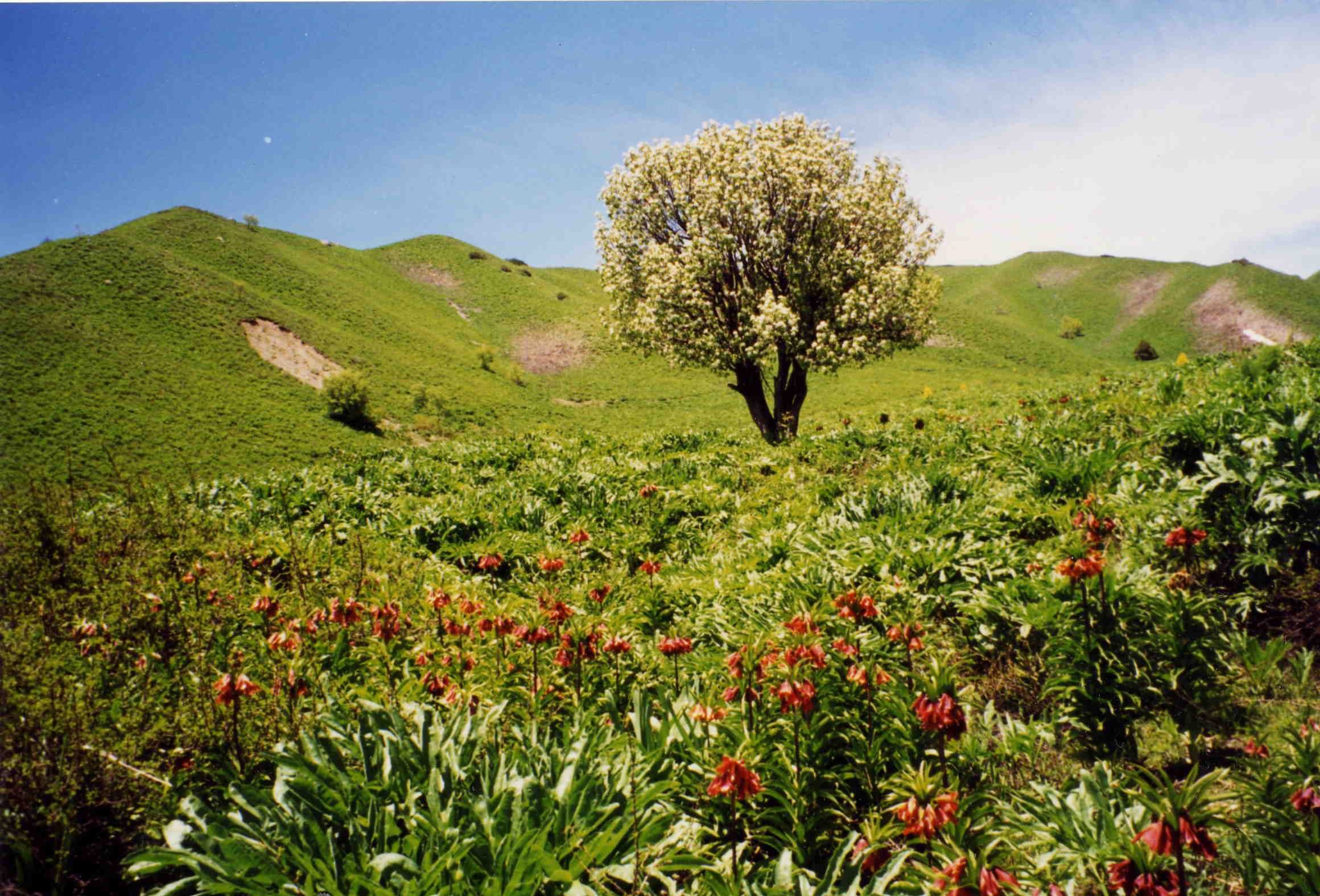
| photo | Ледник Советских офицеров южн. - panoramio (3).jpg |
| photo_caption | Pamir Mountains |
| country | |
| subdivision2_type | States/Provinces |
| subdivision2 | |
| highest | Kongur Tagh |
| elevation_m | 7649 |
| range_coordinates | |
| coordinates | |
| map_image | High Asia Mountain Ranges.jpg |
The Pamir Mountains are a range of mountains between Central Asia and South Asia. They are located at a junction with other notable mountains, namely the Tian Shan, the Karakoram, the Kunlun, the Hindu Kush, and the Himalayas. They are among the world's highest mountains.
Much of the range lies in the Gorno-Badakhshan region of Tajikistan. Spanning the border parts of four countries, to the south, they border the Hindu Kush mountains along Afghanistan's Wakhan Corridor in Badakhshan Province, Chitral and Gilgit-Baltistan regions of Pakistan. To the north, they join the Tian Shan mountains along the Alay Valley of Kyrgyzstan. To the east, they extend to the range that includes China's Kongur Tagh, in the "Eastern Pamirs", separated by the Yarkand valley from the Kunlun Mountains.
|Pamir
Since the Victorian era, they have been known as the "Roof of the World", presumably a translation from Persian.
Names and etymology
In other languages
The Pamir region is home to several different cultures, peoples and languages. In some of these languages, the Pamir Mountains are referred by different names.
In Indo-European languages, they are called:
- Pomīr/Pomer/Pomīr Kūen/Pomer Kūen in Shughni;
- Памир/Памирские горы/Горные вершины Памира ru in Russian;
- پامیر غرونه ps in Pashto;
- رشته کوههای پامیر, Ришта Кӯҳҳои Помир, tg in Tajik;
- {{nq|پامیر کوهستان}} ur in Urdu;
- सुमेरु sa in Sanskrit.
In Turkic languages, they are called:
- پامىر توولورۇ, Памир Тоолору, ky in Kyrgyz;
- پامىر ئېگىزلىكى, ug, Памир Егизлики in Uyghur.
In Chinese, they are referred as "Onion Range" (), which is named after the wild onions growing in the region; In the Dungan dialect of Mandarin, it is written Памир / Цунлин in the Cyrillic alphabet, and in Xiao'erjing it is written پَامِعَر / ڞوْلٍْ. The name "Pamir" is used more commonly in Modern Chinese and loaned as 帕米尔 / 帕米爾 zh.
Geological term
valleyAccording to Middleton and Thomas, "pamir" is also a geological term. and the east and south of Gorno-Badakhshan, as opposed to the valleys and gorges of the west. Pamirs are used for summer pasture.
The Great Pamir is around Lake Zorkul. The Little Pamir is east of this in the far east of Wakhan. The Taghdumbash Pamir is between Tashkurgan and the Wakhan west of the Karakoram Highway. The Alichur Pamir is around Yashil Kul on the Gunt River. The Sarez Pamir is around the town of Murghab, Tajikistan. The Khargush Pamir is south of Lake Karakul. There are several others.
The Pamir River is in the south-west of the Pamirs.
Geography
File:Karakorum-d04.jpg|Kongur Tagh (left) and Kongur Tiube (slightly to the right) as seen from the Karakoram Highway File:Fly over Pamir Mountains and Karakoram Highway.jpg|Slopes of Pamir Mountains on the Chinese side and Muztagh Ata File:Pamir World Wind.jpg|Pamir Mountains from a NASA satellite image, April 2012
Mountain
The three highest mountains in the Pamirs core are Ismoil Somoni Peak (known from 1932 to 1962 as Stalin Peak, and from 1962 to 1998 as Communism Peak), 7495 m; Ibn Sina Peak (still unofficially known as Lenin Peak), 7134 m; and Peak Korzhenevskaya (, Pik Korzhenevskoi), 7105 m. In the Eastern Pamirs, China's Kongur Tagh is the highest at 7649 m.
Among the significant peaks of the Pamir Mountains are the following:
| Native name(s) | Translated name(s) | Height | ||||
|---|---|---|---|---|---|---|
| in meters | Coord. | Sub-range | Country | |||
| Kongur (*Kungur Tagh*) | 7,649 | () | Kongur Shan | |||
| Muztagh Ata | 7,546 | () | Muztagh Ata Massif | |||
| Kongur Jiubie (*Kungur Tjube Tagh*) | 7,530 | () | Kongur Shan | |||
| Ismoil Somoni Peak | ||||||
| (formerly *Communism Peak*, *Stalin Peak*) | 7,495 | () | Academy of Sciences Range | |||
| Lenin Peak | ||||||
| (new name: *Abu Ali Ibn Sino Peak*; | ||||||
| formerly *Kaufmann Peak*) | 7,134 | () | Trans-Alay Range | , | ||
| Peak Ozodi | ||||||
| (formerly *Peak Korzhenevskoi*) | 7,105 | () | Academy of Sciences Range | |||
| Independence Peak | ||||||
| (also *Qullai Istiqlol*, | ||||||
| formerly *Revolution Peak*, *Dreispitz*) | 6,940 | () | Yazgulem Range | |||
| Russia Peak | 6,875 | () | Academy of Sciences Range | |||
| Moscow Peak | 6,785 | () | Peter I Range | |||
| Karl Marx Peak | 6,723 | () | Shakhdara Range | |||
| Kurumdy Mountain | 6,614 | () | Trans-Alay Range | , | ||
| Mount Garmo | 6,595 | () | Academy of Sciences Range | |||
| Engels Peak | 6,510 | () | Shakhdara Range | |||
| Коҳи Памир | Kohi Pamir | 6,320 | () | Wakhan Range | Afghanistan | |
| Пик советских офицеров | Peak of the Soviet Officers | 6,233 | () | Muzkol Range | ||
| Mayakovsky Peak | 6,096 | () | Shakhdara Range | |||
| Patkhor Peak | 6,083 | () | Rushan Range | |||
| Пик Лейпциг | Leipzig Peak | 5,725 | () | Trans-Alay Range | , | |
| Пик Скалистый | Skalisty Peak (Schugnan Range) | 5,707 | () | Schugnan Range | ||
| Кызылдангы | Kysyldangi Peak | 5,704 | () | Southern Alitschur Range |
Remark: The summits of the Kongur and Muztagata Group are in some sources counted as part of the Kunlun, which would make Pik Ismoil Somoni the highest summit of the Pamir.
Glaciers
There are many glaciers in the Pamir Mountains, including the 77 km long Vanch-Yakh Glacier, the longest in the former USSR and the longest glacier outside the polar regions. Approximately 12,500 km2 (ca. 10%) of the Pamirs are glaciated. Glaciers in the Southern Pamirs are retreating rapidly. Ten percent of annual runoff is supposed to originate from retreating glaciers in the Southern Pamirs. In the North-Western Pamirs, glaciers have almost stable mass balances.
Climate
Covered in snow during most of the year, the Pamirs have long and bitterly cold winters, and short, cool summers, which equals an ET (tundra climate) according to Köppen climate classification (EF above the snow line). Annual precipitation is about 130 mm, which supports grasslands but few trees.
Paleoclimatology during the Ice Age
The East-Pamir, in the centre of which the massifs of Mustagh Ata (7620 m) and Kongur Tagh (Qungur Shan, 7578, 7628 or 7830 m) are situated, shows from the western margin of the Tarim Basin an east–west extension of c. 200 km. Its north–south extension from King Ata Tagh up to the northwest Kunlun foothills amounts to c.170 km. Whilst the up to 21 km long current valley glaciers are restricted to mountain massifs exceeding 5600 m in height, during the last glacial period the glacier ice covered the high plateau with its set-up highland relief, continuing west of Mustagh Ata and Kongur. From this glacier area an outlet glacier has flowed down to the north-east through the Gez valley up to c.1850 m asl (meters above sea level) and thus as far as to the margin of the Tarim basin. This outlet glacier received inflow from the Kaiayayilak glacier from the Kongur north flank. From the north-adjacent Kara Bak Tor (Chakragil, c. 6800 or 6694 m) massif, the Oytag valley glacier in the same exposition flowed also down up to c. 1850 m asl. At glacial times the glacier snowline (ELA) as altitude limit between glacier nourishing area and ablation zone, was about 820 to 1250 metres lower than it is today. Under the condition of comparable proportions of precipitation there results from this a glacial depression of temperature of at least 5 to 7.5 °C.
Economy
Coal is mined in the west, though sheep herding in upper meadowlands is the primary source of income for the region.
Exploration
The lapis lazuli found in Egyptian tombs is thought to come from the Pamir area in Badakhshan province of Afghanistan. About 138 BCE Zhang Qian reached the Fergana Valley northwest of the Pamirs. Ptolemy vaguely describes a trade route through the area. From about 600 CE, Buddhist pilgrims travelled on both sides of the Pamirs to reach India from China. In 747 a Tang army was on the Wakhan River. There are various Arab and Chinese reports. Marco Polo may have travelled along the Panj River. In 1602, Bento de Goes travelled from Kabul to Yarkand and left a meager report on the Pamirs. In 1838, Lieutenant John Wood reached the headwaters of the Pamir River. From about 1868 to 1880, a number of Indians in the British service secretly explored the Panj area. In 1873, the British and Russians agreed to an Afghan frontier along the Panj River. From 1871 to around 1893, several Russian military-scientific expeditions mapped out most of the Pamirs (Alexei Pavlovich Fedchenko, Nikolai Severtzov, Captain Dmitry Putyata and others. Later came Nikolai Korzhenevskiy). Several local groups asked for Russian protection from Afghan raiders. The Russians were followed by a number of non-Russians including Ney Elias, George Littledale, the Earl of Dunmore, Wilhelm Filchner and Lord Curzon who was probably the first to reach the Wakhan source of the Oxus River. In 1891, the Russians informed Francis Younghusband that he was on their territory and later escorted a Lieutenant Davidson out of the area ('Pamir Incident'). In 1892, a battalion of Russians under Mikhail Ionov entered the area and camped near the present Murghab. In 1893 they built a proper fort there (Pamirskiy Post). In 1895 their base was moved to Khorog facing the Afghans.
In 1928, the last blank areas around the Fedchenko Glacier were mapped by the German-Soviet Alay-Pamir Expedition under .
Discoveries
In the early 1980s, a deposit of gemstone-quality clinohumite was discovered in the Pamir Mountains. It was the only such deposit known until the discovery of gem-quality material in the Taymyr region of Siberia, in 2000.
The earliest known evidence of human cannabis use was found in tombs at the Jirzankal Cemetery.
Transport

The Pamir Highway, the world's second highest international road, runs from Dushanbe in Tajikistan to Osh in Kyrgyzstan through the Gorno-Badakhshan Autonomous Province, and is the isolated region's main supply route. The Great Silk Road crossed a number of Pamir Mountain ranges.{{cite web |access-date = 2007-08-03 |archive-url = https://web.archive.org/web/20070928082214/http://www.travel-pamir.com/gp3.html |archive-date = 2007-09-28
Tourism
In December 2009, the New York Times featured articles on the possibilities for tourism in the Pamir area of Tajikistan. 2013 proved to be the most successful year ever for tourism in the region and tourism development continues to be the fastest growing economic sector.
Strategic position

Historically, the Pamir Mountains were considered a strategic trade route between Kashgar and Kokand on the Northern Silk Road, a prehistoric trackway, and have been subject to numerous territorial conquests. The Northern Silk Road (about 2600 km in length) connected the ancient Chinese capital Chang'an with Kashgar over the Pamir Mountains towards the west, and from there continued to ancient Parthia. In the 20th century, these mountains have been the setting for the Tajikistan Civil War, border disputes between China and the Soviet Union, establishment of military bases by the US, Russia, and India, and renewed interest in trade development and resource exploration.{{cite web |archive-url=https://web.archive.org/web/20090211183420/http://www.time.com/time/magazine/article/0,9171,1218611-1,00.html |archive-date=February 11, 2009 |access-date=2007-08-26 The Chinese government says it has resolved most of the disputes it had with Central Asian countries.{{cite web |access-date=2017-02-05
Religious symbolism
Some researchers identify the Pamirs with the Mount Meru or Sumeru. The Mount Meru is the sacred five-peaked mountain of Hinduism, Buddhist and Jain, and is considered to be the center of all the physical, metaphysical and spiritual universes.
Notes
References
References
- According to the [http://bse.sci-lib.com/article086489.html ''Big Soviet Encyclopedia''] "The question of the natural boundaries of Pamir is debatable. Normally Pamir is regarded as covering the territory from Trans-Alay Range to the north, Sarykol Range to the east, Lake Zorkul, Pamir River, and the upper reaches of Panj River to the south, and the meridional section of the Panj valley to the west; to the north-west Pamir includes the eastern parts of Peter the Great and Darvaz ranges."
- (2 May 2020). "Pamirs summary - Britannica".
- (1993). "High cooling and denudation rates at Kongur Shan, Eastern Pamir (Xinjiang, China)". Tectonics.
- Bliss, Frank. (2002-06-01). "Social and Economic Change in the Pamirs (Gorno-Badakhshan, Tajikistan): Translated from German by Nicola Pacult and Sonia Guss with support of Tim Sharp". Taylor & Francis.
- Li, Daoyuan. "水經注".
- (2002-04-14). "The origin of the Chinese name "Onion Range" for Pamir". Depts.washington.edu.
- "Aga Khan Development Network (2010): Wakhan and the Afghan Pamir".
- ''Tajikistan: 15 Years of Independence'', statistical yearbook, Dushanbe, 2006, p. 8, in Russian.
- "Dominance".
- In the Karakoram Mountains, [[Siachen Glacier]] is 76 km long, [[Biafo Glacier]] is 67 km long, and [[Baltoro Glacier. Baltoro]] is 63 km long. The [[Bruggen Glacier. Bruggen or Pio XI Glacier]] in southern Chile is 66 km long. Kyrgyzstan's [[South Inylchek Glacier. South Inylchek (Enylchek) Glacier]] is 60.5 km in length. Measurements are from recent imagery, generally with Russian 1:200,000 scale topographic mapping for reference as well as the 1990 ''Orographic Sketch Map: Karakoram: Sheets 1 and 2'', Swiss Foundation for Alpine Research, Zurich.
- (2017-06-13). "Bridging Glaciological and Hydrological Trends in the Pamir Mountains, Central Asia". Water.
- (29 April 2011). "Mendenhall Glacier Facts". [[University of Alaska Southeast]].
- Kuhle, M. (1997):''New findings concerning the Ice Age (LGM) glacier cover of the East Pamir, of the Nanga Parbat up to the Central Himalaya and of Tibet, as well as the Age of the Tibetan Inland Ice.'' Tibet and High Asia (IV). Results of Investigations into High Mountain Geomorphology. Paleo-Glaciology and Climatology of the Pleistocene. GeoJournal, 42, (2–3), pp. 87–257.
- Kuhle, M. (2004):''The High Glacial (Last Ice Age and LGM) glacier cover in High- and Central Asia. Accompanying text to the mapwork in hand with detailed references to the literature of the underlying empirical investigations.'' Ehlers, J., Gibbard, P. L. (Eds.). Extent and Chronology of Glaciations, Vol. 3 (Latin America, Asia, Africa, Australia, Antarctica). Amsterdam, Elsevier B.V., pp. 175–199.
- This section is based on the book by R. Middleton and H. Thomas: Robert Middleton and Huw Thomas, 'Tajikistan and the High Pamirs', Odyssey Books, 2008
- (2019-06-07). "The origins of cannabis smoking: Chemical residue evidence from the first millennium BCE in the Pamirs". Science Advances.
- "''Silk Road, North China'', C.Michael Hogan, the Megalithic Portal, ed. A. Burnham". Megalithic.co.uk.
- Chapman, Graham P.. (2003). "The Geopolitics of South Asia: From Early Empires to the Nuclear Age". Ashgate Publishing.
- George Nathaniel Curzon; The Hindu World: An Encyclopedic Survey of Hinduism, 1968, p 184
- Benjamin Walker - Hinduism; Ancient Indian Tradition & Mythology: {{IAST. Purāṇas in Translation, 1969, p 56
- Jagdish Lal Shastri, Arnold Kunst, G. P. Bhatt, Ganesh Vasudeo Tagare - Oriental literature; Journal of the K.R. Cama Oriental Institute, 1928, p 38
- Bernice Glatzer Rosenthal - History; Geographical Concepts in Ancient India, 1967, p 50
- Bechan Dube - India; Geographical Data in the Early {{IAST. Purāṇas: A Critical Study, 1972, p 2
- Dr M. R. Singh - India; Studies in the Proto-history of India, 1971, p 17
- Gopal, Madan. (1990). "India through the ages". Publication Division, Ministry of Information and Broadcasting, Government of India.
This article was imported from Wikipedia and is available under the Creative Commons Attribution-ShareAlike 4.0 License. Content has been adapted to SurfDoc format. Original contributors can be found on the article history page.
Ask Mako anything about Pamir Mountains — get instant answers, deeper analysis, and related topics.
Research with MakoFree with your Surf account
Create a free account to save articles, ask Mako questions, and organize your research.
Sign up freeThis content may have been generated or modified by AI. CloudSurf Software LLC is not responsible for the accuracy, completeness, or reliability of AI-generated content. Always verify important information from primary sources.
Report