From Surf Wiki (app.surf) — the open knowledge base
Oxford Street, Sydney
Road in Sydney, Australia

Road in Sydney, Australia
| Field | Value | |
|---|---|---|
| urban | yes | |
| road_name | Oxford Street, Sydney | |
| state | nsw | |
| type | street | |
| image | Oxford Street Sydney.JPG | |
| caption | Darlinghurst, 2007 | |
| length | 4.5 | |
| length_ref | ||
| gazetted | August 1928 | |
| gazetted_ref | ||
| mapframe | no | |
| alternative_location_map | Australia NSW east Sydney | |
| coordinates_a | ||
| coordinates_b | ||
| pushpin_label_position_a | left | |
| pushpin_label_position_b | right | |
| direction_a | Western | |
| direction_b | Eastern | |
| end_a | **Liverpool Street** | |
| Darlinghurst, Sydney | ||
| end_b | **Old South Head Road** | |
| Bondi Junction, Sydney | ||
| exits | {{plainlist | |
| through | Paddington, Woollahra |
Darlinghurst, Sydney Bondi Junction, Sydney
- College Street
- Crown Street
- Flinders Street
- South Dowling Street
- Moore Park Road
- Syd Einfeld Drive
- Bondi Road
Oxford Street is a major thoroughfare in Sydney, New South Wales, Australia, running from the south-east border of the Sydney central business district to Bondi Junction in the Eastern Suburbs. Close to the CBD in particular, the street is lined with numerous shops, bars and nightclubs. After the 1980s, Oxford Street garnered a reputation as Sydney's primary nightclub strip (firstly gay nightclubs in the 1980s followed by straight nightclubs in the 2000s) and subsequently saw a large increase in the number of crimes committed in the area. However, the 2014 lockout laws saw many nightclubs close and the crime rate drop as Sydney's nightlife hubs moved to Darling Harbour and Newtown. The lockout laws ended in 2020 with a focus on small bars and restaurants. Many nightclubs reopened after 2021 especially around Taylor Square. Oxford street hosted World Pride in 2023. A major redevelopment, called Oxford & Foley, is expected to be completed in 2025.
The western section of Oxford Street, which runs through the suburb of Darlinghurst, is widely recognised as Sydney's main gay district and Oxford Street is closed to traffic once a year in early March for the Sydney Gay and Lesbian Mardi Gras. Specifically, the area of Oxford Street between Hyde Park and Paddington Town Hall became known from the early 1980s as 'The Golden Mile' because of the growing density of popular venues for the gay community. The section to the east of Taylor Square, running through the suburb of Paddington forms an upmarket shopping strip and represents the home of the new medical faculty of the University of Notre Dame Australia as well as the University of New South Wales' College of Fine Arts, Victoria Barracks, Paddington Bazaar and St Vincent's Hospital, Sydney amongst other locations.
Route
Oxford Street starts at Whitlam Square on the south-east corner of Hyde Park at the intersection of Liverpool Street, College Street and Wentworth Avenue on the south-eastern fringe of central Sydney and heads in a south-easterly direction as a four-lane, single-carriageway road through Darlinghurst, where it meets Bourke Street and Flinders Street at Taylor Square. It continues through Paddington, and branches off at the intersection with Syd Einfeld Drive in Woollahra to become a suburban street through Bondi Junction; a portion of it has been converted into a pedestrian mall through its commercial centre. It continues east to terminate a short distance later at the intersection of Old South Head Road, Syd Einfeld Drive and Bondi Road in eastern Bondi Junction.
History
In May 1909 the Sydney Council resolved to widen Oxford Street from 66 ft to 100 ft by resuming the entire north side of the street between Liverpool and Bourke Streets. The project was carried out in five stages between 1910 and 1914. The result was a new boulevard and the creation of a Federation streetscape which remains today largely intact.
Trams to Bondi and Bronte beaches travelled down Oxford Street until the line was closed in 1960, replaced by the current bus service.
Paddington Reservoir

Main article: Paddington Reservoir, Sydney
Located on the corner of Oatley Road and Oxford Street is the Paddington Reservoir, a water reservoir which provided water to the Botany Swamps pumping station for the provision of water to parts of Sydney between 1866 and 1899. In 2006 work began to restore and reuse the space of the then derelict Paddington Reservoir. The facility reopened in 2008 as a sunken garden known as the Paddington Reservoir Gardens or Walter Read Reserve, with a rooftop reserve located above the preserved eastern chamber. The facility integrates the remains of the original brick, timber and iron structure with modern elements of sculptural, structural and functional significance which provide access to the sunken garden via stairs and an elevator as well as ramped access to the rooftop reserve.
Victoria Barracks
Main article: Victoria Barracks, Sydney
Victoria Barracks, located in Oxford Street, houses the Headquarters Forces Command (Australia), as well as the Army Museum of NSW which is housed in the original District Military Prison, constructed in 1800. The barracks was constructed of Hawkesbury sandstone by way of convict labour between 1841 and 1846. The Barracks were originally occupied by regiments of the British Army who vacated the site in 1870. The Barracks was the premier military training site in Australia until 1901. For a brief period during the 1930s Victoria Barracks was home to the Royal Military College, Duntroon when the College was forced to close its buildings in Canberra and relocate to Sydney due to the economic downturn caused by the Great Depression.
Road classification
The passing of the Main Roads Act of 1924 through the Parliament of New South Wales provided for the declaration of Main Roads, roads partially funded by the State government through the Main Roads Board. Main Road No. 172 was declared along this road on 8 August 1928, from the boundary with the City of Sydney to Bondi Junction (and continuing east along Bondi Road to Bondi); with the passing of the Main Roads (Amendment) Act of 1929 to provide for additional declarations of State Highways and Trunk Roads, this was amended to Main Road 172 on 8 April 1929. Its western end was altered to commence at Taylor Square on 2 December 1964, re-aligned along the Bondi Junction Bypass (later named Syd Einfeld Drive when it opened in 1979), then moved closer to the city to start at the intersection with Crown Street on 25 July 1997.
The passing of the Roads Act of 1993 updated road classifications and the way they could be declared within New South Wales. Under this act, Oxford Street retains its declaration as part of Main Road 172.
Heritage buildings
The following buildings are on the Register of the National Estate:
- Victoria Barracks (1841–48)
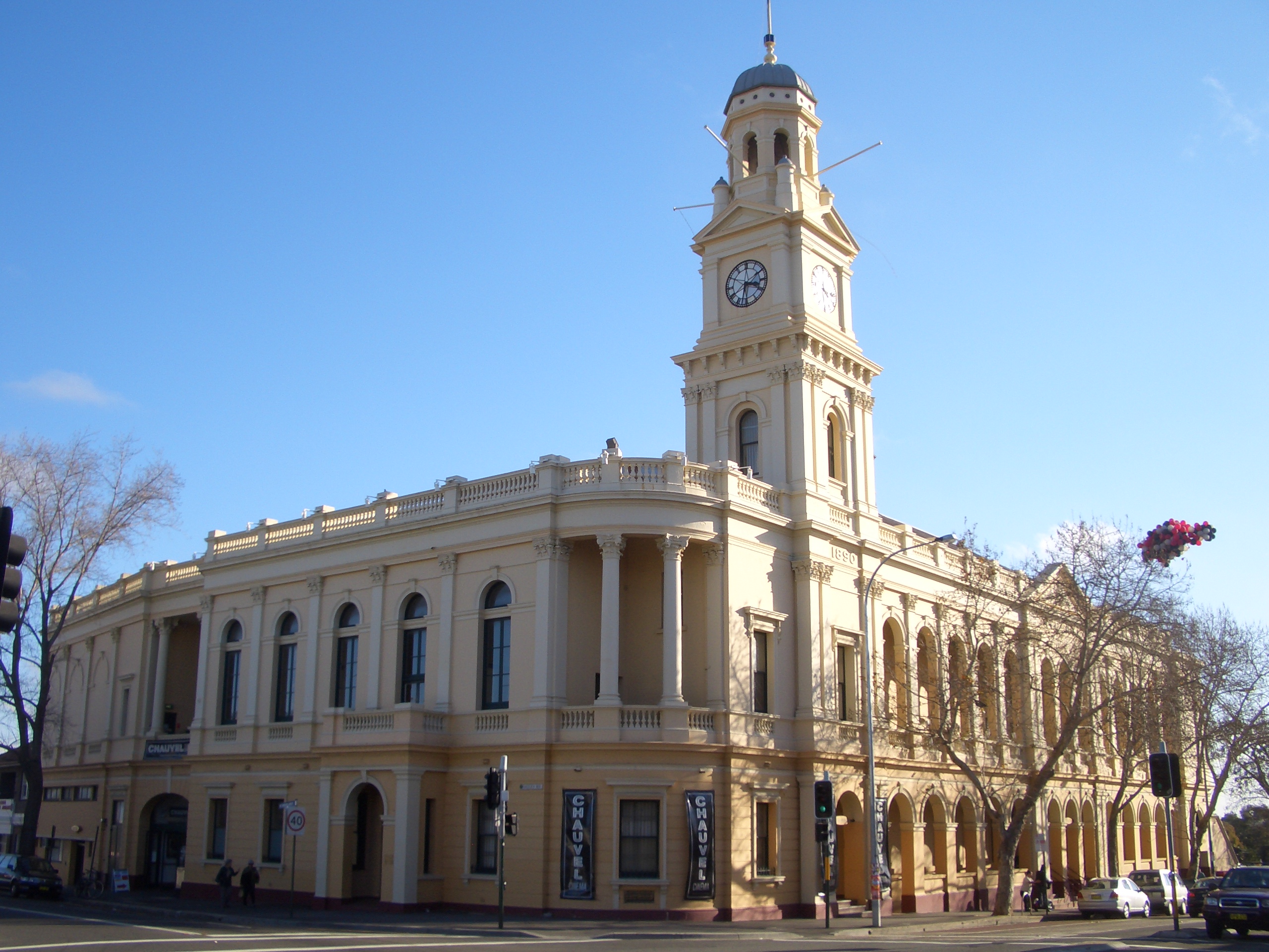
- Paddington Town Hall (1890–91)
- Paddington Public School (1870 and 1892 buildings)
- Uniting Church and Parsonage (1877)
- St Matthias Church Group (1859–61)
- Former St Mattias Rectory (1873)
- St Matthias Church Hall (1882)
- Post Office (1885)
Oxford Street Mall

The pedestrian-only zone of Oxford Street between Bronte Road and Newland Street, Bondi Junction was converted into a pedestrian mall in 1979 when the Eastern Suburbs railway line opened. Prior to the 1960 trams ran along that stretch of Oxford Street. Oxford Street Mall was an alternative to shopping at the nearby shopping centres as it was once home Waltons department store, Flemings and Woolworths Supermarkets and a Timezone arcade. However these stores have since disappeared prior to the 1990s.
Oxford Street Mall is home to numerous shops and cafes and is an entry to many small arcades and shopping centres that are located on this stretch including Meriton Retail Precinct Bondi Junction, Bronka Arcade and The Royal Arcade. Bondi Junction railway station can be accessed through the Meriton Retail Precinct on Rowe Street. Bronka and The Royal Arcade provides direct pedestrian passage way to Spring Street and Eastgate Bondi Junction. Westfield Bondi Junction is located on the Bronte Road end of Oxford Street Mall.
In 2003, Waverley Council upgraded the Oxford Street pedestrian mall and embarked on a general upgrade of streets and footpaths in the commercial area. The upgrade included new footpath tiles, addition of shade sails over new inground rondels and artificial 'tram tracks' along the entire mall, paving text as cast inlays and glass bead blasting into paving and as well as suspended art installations. The artificial tram tracks are the main features of the mall that commemorate the actual tram line that previously passed through.
Since 2013 there were plans for a light rail to Bondi Beach going along Oxford Street Mall. However in November 2017 Waverley Council had voted to reject any proposals for a light rail along Oxford Street or Bondi Road in favour of local businesses.
Oxford Street Cycleway
After the 2023 WorldPride festival a bidirectional separated cycleway will be constructed between Taylor Square and Hyde Park on Oxford street.
The City of Sydney announced the original design for a bidirectional centre running "pop up" cycleway in November 2020. After further consultation they announced a new design running on the north edge of the street, and is was completed in 2025.
According to the City of Sydney, about 2000 people per day ride along Oxford Street amongst traffic on the six lane road.
Oxford Street revival
2011
On 27 June 2011, the Lord Mayor of Sydney, Clover Moore proposed new directions for lower Oxford Street, and on 22 August 2011 the Council resolved to undertake a number of short, medium and long term initiatives to activate City owned properties in the precinct. After an Expression of Interest (EOI) was put out for creative and cultural organisations to occupy a vacant city owned property, 16 organisations were announced as being successful applicants and were granted office space as part of the Sydney 2030 plan to revitalise the Oxford Street Precinct with creative and cultural organisations that could help to drive foot traffic to the area as well as promote the community. The 16 organisations that were part of this programme were:
- AroundYou
- The Fortynine
- SCALE Architecture
- Queer ScreenMusic NSW
- Sydney Guild
- Dr Egg
- New Media Production Group
- Homework
- EngineRoom by Fishburners
- Rouse Phillips Textile Studio
- PROVINCE
- Envelop Entertainment
- World Famous Westsyde
- He Made She Made
- Platform72
- Under New Management
2021–present
The City of Sydney unveiled a plan to "breathe new life" into the strip by updating the zoning rules along the strip, including increasing building height limits if developers comply with including community focused uses in the building.
A major redevelopment, called Oxford & Foley, spanning three blocks on the north side of the strip, is expected to be completed in 2025.
Major intersections
Wentworth Avenue (south) Barcom Avenue (one-way northeast bound) – Darlinghurst South Downling Street (south), Sydney Airport Lang Road (south) Ocean Street (north) – Woollahra Wallis Street (one-way eastbound) – Woollahra Bondi Road (southeast)
References
References
- "Oxford Street".
- (17 August 1928). "Main Roads Act, 1924-1927". National Library of Australia.
- (2021-02-10). "Raise a glass to a revived global city after the end of Sydney's draconian lockout laws {{!}} Gary Nunn".
- Wotherspoon, Garry. (2016). "Gay Sydney: A History". NewSouth Publishing.
- Gregory's Street Directory, 2004, Maps 346,376,377
- Odgers 1988, p. 108.
- [http://classic.austlii.edu.au/au/legis/nsw/num_act/mra1924n24133/ State of New South Wales, ''An Act to provide for the better construction, maintenance, and financing of main roads; to provide for developmental roads; to constitute a Main Roads Board''] {{webarchive. link. (11 August 2022 10 November 1924)
- [https://legislation.nsw.gov.au/view/pdf/asmade/act-1929-15 State of New South Wales, ''An Act to amend the Main Roads Act, 1924-1927; to confer certain further powers upon the Main Roads Board; to amend the Local Government Act, 1919, and certain other Acts; to validate certain payments and other matters; and for purposes connected therewith.''] {{webarchive. link. (12 August 2022 8 April 1929)
- (4 December 1964). "Main Roads Act, 1924-1963". National Library of Australia.
- (25 July 1997). "Roads Act". National Library of Australia.
- [https://legislation.nsw.gov.au/view/html/inforce/current/act-1993-033 State of New South Wales, ''An Act to make provision with respect to the roads of New South Wales; to repeal the State Roads Act 1986, the Crown and Other Roads Act 1990 and certain other enactments; and for other purposes.''] {{webarchive. link. (11 August 2022 10 November 1924)
- [[Transport for NSW]]. (August 2022). "Schedule of Classified Roads and Unclassified Regional Roads". Government of New South Wales.
- The Heritage of Australia, Macmillan Company, 1981, pp.2/84-85
- Howe, Megan (10 November 1988). "Paddington Youth Refuge Faces The Threat of Eviction." ''[[Sydney Morning Herald]]''
- The building was later used as the [[Caretakers Cottage]] Youth Refuge, from 1975 to 1990.
- [https://archive.today/20120801160755/http://www.heritage.nsw.gov.au/07_subnav_01_2.cfm?itemid=5051289 State Government Heritage Site]
- "Oxford Street Mall Redevelopment – Artwork (File No. 18-3-35(2)". Waverly Council.
- "Remnants of the Bondi Trams".
- McDonald, Shae. (2013-07-10). "All aboard for Bondi tram as Waverley Council considers light rail down Oxford St Mall". [[Daily Telegraph (Sydney).
- (2015-10-07). "Waverley Council lobbies State Government for Bondi Beach tram to ease traffic chaos". [[Daily Telegraph (Sydney).
- (2015-10-07). "Waverley Council lobbies State Government for Bondi Beach tram to ease traffic chaos". [[Daily Telegraph (Sydney).
- (2022-11-28). "Date set for Oxford Street cycleway build".
- "A new cycleway for Oxford and Liverpool streets {{!}} City of Sydney - News".
- NSW, Transport for. (2023-01-12). "Oxford Street East Cycleway".
- Nicole Hasham (9 January 2012). [https://www.smh.com.au/nsw/city-adopts-creative-bent-to-revive-oxford-street-20120108-1pq7u.html "City adopts creative bent to revive Oxford Street"]. ''The Sydney Morning Herald''. AAP. Retrieved 10 March 2014.
- Gorrey, Megan. (2021-05-20). "'It will be returned to its heyday': Taller buildings and rooftop bars to transform Oxford Street".
- "Welcome to Oxford & Foley, Sydney".
This article was imported from Wikipedia and is available under the Creative Commons Attribution-ShareAlike 4.0 License. Content has been adapted to SurfDoc format. Original contributors can be found on the article history page.
Ask Mako anything about Oxford Street, Sydney — get instant answers, deeper analysis, and related topics.
Research with MakoFree with your Surf account
Create a free account to save articles, ask Mako questions, and organize your research.
Sign up freeThis content may have been generated or modified by AI. CloudSurf Software LLC is not responsible for the accuracy, completeness, or reliability of AI-generated content. Always verify important information from primary sources.
Report