From Surf Wiki (app.surf) — the open knowledge base
Mountain states
Region of the United States

Region of the United States
The Mountain states (also known as the Mountain West or the Interior West) form one of the nine geographic divisions of the United States that are officially recognized by the United States Census Bureau. It is a subregion of the Western United States.
The Mountain states are considered to include: Arizona, Colorado, Idaho, Montana, Nevada, New Mexico, Utah and Wyoming. The words "Mountain states" generally refer to the U.S. States which encompass the U.S. Rocky Mountains. These are oriented north-south through portions of the states of Montana, Idaho, Wyoming, Colorado, Utah, and New Mexico. Arizona and Nevada, as well as other parts of Utah and New Mexico, have other smaller mountain ranges and scattered mountains located in them as well. Sometimes, the Trans-Pecos area of West Texas is considered part of the region. The land area of the eight states together is some 855,767 sqmi.
It is the fastest-growing region in the United States, with Utah, Idaho, Nevada, Colorado, and Arizona ranking among the fastest-growing states in the country. Phoenix is its largest city.
A few subregions exist within this region:
- The Southwest region, consisting of Arizona, New Mexico, Southern Nevada, and Far West Texas
- The Intermountain region, consisting of Utah, Nevada, and Idaho, along with portions of other states
- The Front Range region, consisting of Northern New Mexico, Colorado, and Southeast Wyoming
Regional geography
The Mountain West is one of the largest and most diverse regions in the United States. Most regional boundaries of the Mountain West are often looked at the area from the High Plains to the Sierra Nevada and the Cascade Range. The southern and northern portions of the Mountain West are often split into two separate regions. The southern portion (Arizona and New Mexico) is often called the Southwest region, while the northern portion (Idaho and Montana) is often included in either the Northwest states or called the "Northern Rockies".
Terrain
Together with the Pacific States of Alaska, California, Hawaii, Oregon, and Washington, the Mountain states constitute the broader region of the West, one of the four regions the United States Census Bureau formally recognizes (the Northeast, South, and Midwest being the other three). The terrain of the Mountain West is more diverse than any other region in the United States. Its physical geography ranges from some of the highest mountain peaks in the continental United States to large desert lands and rolling plains in the eastern portion of the region. The Great Basin Desert is located in almost all of Nevada, western Utah, and southern Idaho. Portions of the Mojave Desert are located in California, but over half of the desert is located in southern Nevada, in the Mountain West. Meanwhile, the Sonoran Desert is located in much of Arizona, and the Chihuahuan Desert is located in most of southwestern and southern New Mexico, including White Sands and Jornada del Muerto. Colorado also has scattered desert lands in the southern and northwestern portions of the state, including the expansive San Luis Valley.
Colorado, New Mexico, Utah, and Arizona have other smaller desert lands, part of the Colorado Plateau. The Painted Desert is located in northern and northeastern Arizona, and the San Rafael Desert is located in eastern Utah. New Mexico has other desert lands located in the northern and northwest. Colorado has large desert lands on the colorado plateau in the northwestern, western, and southern parts of the state. These desert lands in Colorado are located in and around areas such as Royal Gorge, Great Sand Dunes National Park, Pueblo, the San Luis Valley, Cortez, Dove Creek, Delta, Canyons of the Ancients National Monument, the Roan Plateau, Dinosaur National Monument, Colorado National Monument, and the Grand Mesa. The San Luis Valley is the largest high valley desert in the world.
In the far-eastern portions of the Mountain West are the High Plains, a portion of the Great Plains. These plains mainly consist of flat rolling land, with scattered buttes, canyons, and forests located in these areas. The High Plains receive very little rainfall, and sit at high elevations, usually about 3000 to. Many people view the High Plains as the point where one begins to enter the greater Mountain West region.
Mountain ranges are located throughout the Mountain West, although the highest mountains are located in the Southern Rocky Mountains of Colorado.
| Rank | Mountain peak | State | Mountain range | Elevation | Prominence | Isolation | Location |
|---|---|---|---|---|---|---|---|
| 1 | Sawatch Range | ||||||
| 2 | Colorado | Sawatch Range | |||||
| 3 | Colorado | Sawatch Range | |||||
| 4 | Colorado | Sangre de Cristo Mountains | |||||
| 5 | Colorado | Sawatch Range | |||||
| 6 | Colorado | San Juan Mountains | |||||
| 7 | Colorado | Sangre de Cristo Range | |||||
| 8 | Colorado | Mosquito Range | |||||
| 9 | Colorado | Elk Mountains | |||||
| 10 | Colorado | Front Range |
Climate
The climate of the Mountain West is one of the more diverse climates in the United States. The entire region generally features a semi-arid or arid climate, with somе alpine climates in the mountains of each state. Some parts of the tall mountains can receive very large amounts of snow and rain, while other parts of the region received very little rain, and virtually no snow at all. The High Plains in the eastern portion of the region receive moderate snowfalls, but very little rain.
The states of Nevada and Arizona are generally filled with desert lands and scattered mountain ranges. Much of Nevada receives little to no snow in the southern portion of the state, while northern Nevada can receive large amounts of snow in and around the mountains, and even in the desert lands in Nevada. Arizona generally receives little rain or snow, but high elevations in and near mountains receive extremely large amounts of rain and snow. Northern and northeastern Arizona display characteristics of a "High Desert", where the summers are very hot and dry, while the winters can become very cold, and it can snow as well.
Utah is also generally large desert lands, with mountains as well. However, the desert lands in Utah receive significant snowfall, and there are large amounts of snowfall on and around the mountains. Colorado and New Mexico have very similar climates. Both states can receive significant snowfalls off the mountains, while the mountains in both states receive extremely large amounts of snow. However, southern and southwestern New Mexico generally does not receive much snow at all, similar to southern Nevada and southern Arizona. The desert lands found in northeastern Arizona, eastern Utah, northern New Mexico, and western and southern Colorado are generally referred to as the "High Desert" lands.
The northern portion of the Mountain West tends to be a bit cooler than the southwestern areas. Idaho and Montana both receive significant snowfalls off the mountains and very large snowfalls in the mountains. The High Desert also exists in the northern Mountain West. Southeastern Oregon and southern Idaho have the Great Basin Desert lands located in them, which is part of the high desert.
The eight Mountain states have the highest mean elevations of all 50 U.S. states.
States
| Rank | State | Highest point | Highest elevation | Lowest point | Lowest elevation | Mean elevation | Elevation span |
|---|---|---|---|---|---|---|---|
| 1 | Colorado | Mount Elbert | id=KL0637 | designation=Mount Elbert | access-date=October 20, 2011 | Arikaree River at Kansas border | |
| 2 | Wyoming | Gannett Peak | id=OW0356 | designation=Gannett Peak Cairn | access-date=October 20, 2011 | Belle Fourche River at South Dakota border | |
| 3 | Utah | Kings Peak | id=LO1058 | designation=Kings Peak Target | access-date=October 20, 2011 | Beaver Dam Wash at Arizona border | |
| 4 | New Mexico | Wheeler Peak | id=GM0779 | designation=Wheeler | access-date=October 20, 2011 | Red Bluff on Texas border | |
| 5 | Nevada | Boundary Peak | id=HR2576 | designation=Boundary | access-date=October 20, 2011 | Colorado River at California border | |
| 6 | Idaho | Borah Peak | id=PZ0770 | designation=Beauty Reset | access-date=October 20, 2011 | Snake River at Washington border | |
| 7 | Arizona | Humphreys Peak | id=FQ0624 | designation=Frisco | access-date=October 20, 2011 | Colorado River at Sonora border | |
| 8 | Montana | Granite Peak | id=QW0616 | designation=Granite Peak | access-date=October 20, 2011 | Kootenai River at Idaho border. | |
| **** | Mount Elbert | Colorado River at Sonora border. |
Demographics
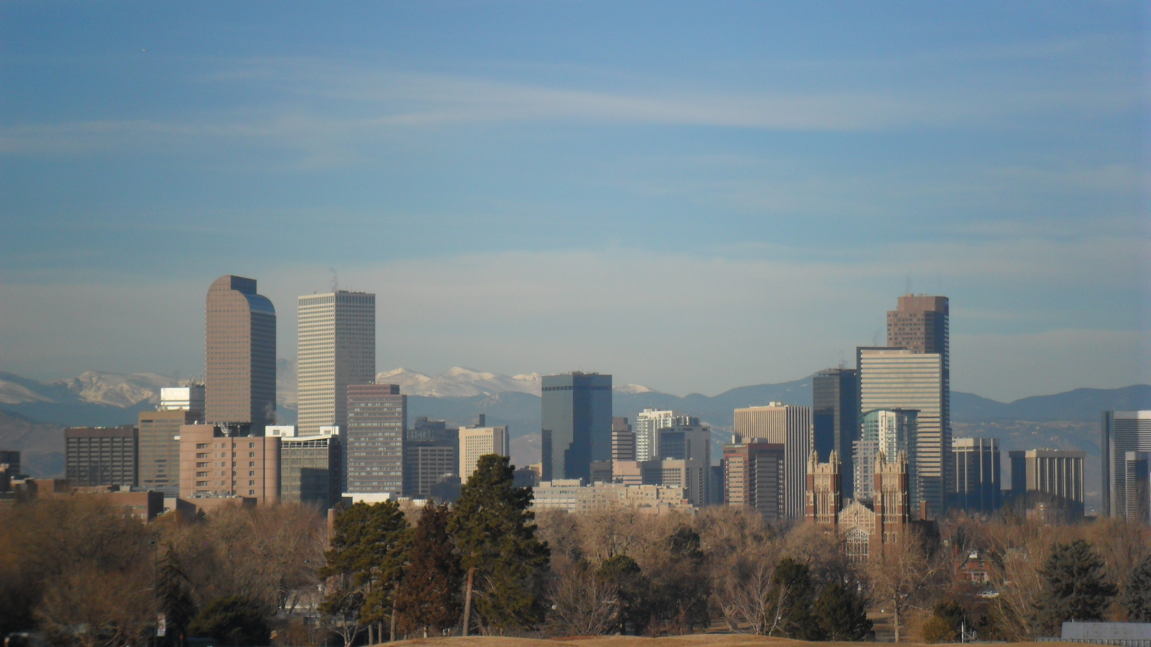
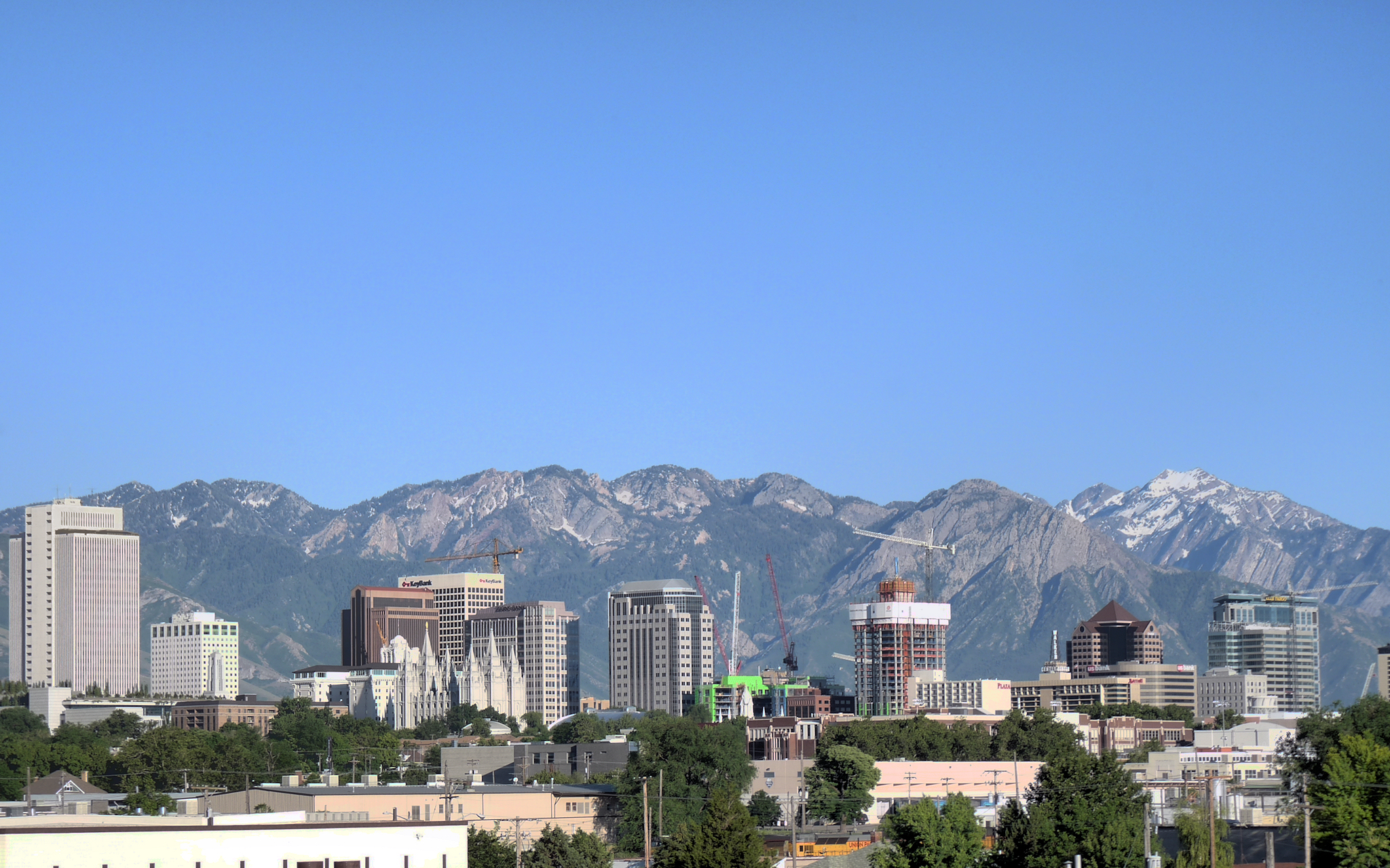
The Phoenix metropolitan area is the most populous metropolitan area of the Mountain states, followed by Denver, Las Vegas, and Salt Lake City. Phoenix is also the most populous city.


The following table is a ranking of cities within the Mountain states region, by city population.
| Rank | City | State | [2020 pop](2020-united-states-census) | [2010 pop](2010-united-states-census) | Change |
|---|---|---|---|---|---|
| 1 | Phoenix | Arizona | |||
| 2 | Denver | Colorado | |||
| 3 | Las Vegas | Nevada | |||
| 4 | Albuquerque | New Mexico | |||
| 5 | Tucson | Arizona | |||
| 6 | Mesa | Arizona | |||
| 7 | Colorado Springs | Colorado | |||
| 8 | Aurora | Colorado | |||
| 9 | Henderson | Nevada | |||
| 10 | Chandler | Arizona | |||
| 11 | Gilbert | Arizona | |||
| 12 | Reno | Nevada | |||
| 13 | North Las Vegas | Nevada | |||
| 14 | Glendale | Arizona | |||
| 15 | Scottsdale | Arizona | |||
| 16 | Boise | Idaho | |||
| 17 | Salt Lake City | Utah | |||
| 18 | Peoria | Arizona | |||
| 19 | Tempe | Arizona | |||
| 20 | Fort Collins | Colorado | |||
| 21 | Lakewood | Colorado | |||
| 22 | Surprise | Arizona | |||
| 23 | Thornton | Colorado | |||
| 24 | West Valley City | Utah | |||
| 25 | Arvada | Colorado | |||
| 26 | Meridian | Idaho | |||
| 27 | Billings | Montana | |||
| 28 | West Jordan | Utah | |||
| 29 | Westminster | Colorado | |||
| 30 | Provo | Utah |
Census statistical areas
| Rank | CBSA | [2020 pop](2020-united-states-census) | [2010 pop](2010-united-states-census) | Change |
|---|---|---|---|---|
| 1 | Phoenix–Mesa–Scottsdale, AZ MSA | |||
| 2 | Denver-Aurora-Centennial, CO MSA | |||
| 3 | Las Vegas, NV MSA | |||
| 4 | Salt Lake City, UT MSA | |||
| 5 | Tucson, AZ MSA | |||
| 6 | Albuquerque, NM MSA | |||
| 7 | Boise City, ID MSA | |||
| 8 | Colorado Springs, CO MSA | |||
| 9 | Ogden-Clearfield, UT MSA | |||
| 10 | Provo-Orem, UT MSA | |||
| 11 | Reno, NV MSA | |||
| 12 | Fort Collins, CO MSA | |||
| 13 | Boulder, CO MSA | |||
| 14 | Greeley, CO MSA | |||
| 15 | Prescott, AZ MSA | |||
| 16 | Las Cruces, NM MSA | |||
| 17 | Lake Havasu City-Kingman, AZ MSA | |||
| 18 | Yuma, AZ MSA | |||
| 19 | Billings, MT MSA | |||
| 20 | Saint George, UT MSA | |||
| 21 | Coeur d'Alene, ID MSA | |||
| 22 | Pueblo, CO MSA | |||
| 23 | Idaho Falls, ID MSA | |||
| 24 | Grand Junction, CO MSA | |||
| 25 | Santa Fe, NM MSA | |||
| 26 | Logan, UT-ID MSA | |||
| 27 | Flagstaff, AZ MSA | |||
| 28 | Sierra Vista-Douglas, AZ MSA | |||
| 29 | Farmington, NM MSA | |||
| 30 | Missoula, MT MSA |
| Rank | CSA | 2014 pop | [2010 pop](2010-united-states-census) | Change | Component CBSAs |
|---|---|---|---|---|---|
| 1 | Denver-Aurora-Greeley, CO CSA | Boulder, CO MSA | |||
| Denver-Aurora-Centennial, CO MSA | |||||
| Greeley, CO MSA | |||||
| 2 | Salt Lake City-Provo-Orem, UT CSA | Heber, UT μSA | |||
| Ogden-Clearfield, UT MSA | |||||
| Provo-Orem, UT MSA | |||||
| Salt Lake City, UT MSA | |||||
| 3 | Las Vegas, NV CSA | Lake Havasu City-Kingman, AZ MSA | |||
| Las Vegas-Henderson-Paradise, NV MSA | |||||
| Pahrump, NV μSA | |||||
| 4 | Albuquerque-Santa Fe-Las Vegas, NM Combined Statistical Area | Albuquerque MSA | |||
| Espanola, NM μSA | |||||
| Grants, NM μSA | |||||
| Las Vegas, NM μSA | |||||
| Los Alamos, NM μSA | |||||
| Santa Fe, NM MSA | |||||
| 5 | Tucson-Nogales, AZ CSA | Nogales, AZ μSA | |||
| Tucson, AZ MSA | |||||
| 6 | Boise City-Mountain Home-Ontario, ID-OR CSA | Boise City, ID MSA | |||
| Mountain Home, ID μSA | |||||
| Ontario, OR-ID μSA | |||||
| 7 | Reno-Carson City-Fernley, NV CSA | Carson City, NV MSA | |||
| Fernley, NV μSA | |||||
| Gardnerville Ranchos, NV μSA | |||||
| Reno-Sparks, NV MSA | |||||
| 8 | Idaho Falls-Rexburg-Blackfoot, ID CSA | Idaho Falls, ID MSA | |||
| Blackfoot, ID μSA | |||||
| Rexburg, ID μSA | |||||
| 9 | Pueblo-Cañon City, CO CSA | Cañon City, CO μSA | |||
| Pueblo, CO MSA | |||||
| 10 | Edwards-Glenwood Springs, CO CSA | Edwards, CO μSA | |||
| Glenwood Springs, CO μSA | |||||
| 11 | Clovis-Portales, NM CSA | Clovis, NM μSA | |||
| Portales, NM μSA | |||||
| 12 | Steamboat Springs-Craig, CO Combined Statistical Area | Craig, CO μSA | |||
| Steamboat Springs, CO μSA |
Gallery
File:Sedona Arizona (Flickr4941867781).jpg|Bell Rock near Sedona, Arizona File:Allen Street Tombstone.jpg|Tombstone, Arizona File:Great Sand Dunes NP 1.JPG|Great Sand Dunes National Park in Colorado File:Mesa Verde USA5.jpg|The Cliff Palace in Mesa Verde National Park in Colorado File:Lake CO.JPG|Hanging Lake near Glenwood Springs, Colorado File:Mt. Elbert.jpg|Mount Elbert in Colorado is the highest summit in the Mountain states. File:BorahPeakID.jpg|Borah Peak is the highest point in the state of Idaho. File:Redfish lake.JPG|Redfish Lake in Idaho File:Detroit Photographic Company (0326).jpg|Shoshone Falls on the Snake River in Idaho, 1898 File:NorthernAbsarokasNearLivingstonMontana2010.jpg|The Absaroka Range of Montana. File:Chief Mountain.jpg|Autumn comes to Chief Mountain in Glacier National Park in Montana. File:Feral horses - Pryor Mountain Wild Horse Range - Montana.jpg|Feral horses in the Pryor Mountain Wild Horse Range in Montana File:Something To Remember You By.jpg|Saint Mary Lake in Glacier National Park in Montana File:Stella Lake Great Basin.jpg|Stella Lake in Great Basin National Park in Nevada File:Lake Tahoe NV.jpg|The Nevada shore of Lake Tahoe File:Reno downtown.jpg|Downtown Reno, Nevada File:Palace of the Governors Santa Fe.JPG|Palace of the Governors in Santa Fe, New Mexico File:USA 09669 Taos Pueblo Luca Galuzzi 2007.jpg|The Taos Pueblo of New Mexico File:USA.NM.VeryLargeArray.02.jpg|The Very Large Array near Socorro, New Mexico File:White sands moon & clouds.jpg|Moonrise at White Sands National Park in New Mexico File:Delicate arch sunset.jpg|Sunset at Delicate Arch in Arches National Park in Utah File:Hayabusa. at Bonneville salt flats 2009.jpg|The Bonneville Salt Flats in Utah File:Mesa Arch Canyonlands National Park.jpg|Mesa Arch in Canyonlands National Park in Utah
Politics
| Democratic | Republican | Populist |
|---|
- Bold denotes election winner.
| Year | Arizona | Colorado | Idaho | Montana | Nevada | New Mexico | Utah | Wyoming | Year | Arizona | Colorado | Idaho | Montana | Nevada | New Mexico | Utah | Wyoming | ||||||||
|---|---|---|---|---|---|---|---|---|---|---|---|---|---|---|---|---|---|---|---|---|---|---|---|---|---|
| [1864](1864-united-states-presidential-election) | No election | No election | No election | No election | **Lincoln** | No election | No election | No election | |||||||||||||||||
| [1868](1868-united-states-presidential-election) | No election | No election | No election | No election | **Grant** | No election | No election | No election | |||||||||||||||||
| [1872](1872-united-states-presidential-election) | No election | No election | No election | No election | **Grant** | No election | No election | No election | |||||||||||||||||
| [1876](1876-united-states-presidential-election) | No election | **Hayes** | No election | No election | **Hayes** | No election | No election | No election | |||||||||||||||||
| [1880](1880-united-states-presidential-election) | No election | **Garfield** | No election | No election | Hancock | No election | No election | No election | |||||||||||||||||
| [1884](1884-united-states-presidential-election) | No election | Blaine | No election | No election | Blaine | No election | No election | No election | |||||||||||||||||
| [1888](1888-united-states-presidential-election) | No election | **Harrison** | No election | No election | **Harrison** | No election | No election | No election | |||||||||||||||||
| [1892](1892-united-states-presidential-election) | No election | Weaver | Weaver | Harrison | Weaver | No election | No election | Harrison | |||||||||||||||||
| [1896](1896-united-states-presidential-election) | No election | Bryan | Bryan | Bryan | Bryan | No election | Bryan | Bryan | |||||||||||||||||
| [1900](1900-united-states-presidential-election) | No election | Bryan | Bryan | Bryan | Bryan | No election | **McKinley** | **McKinley** | |||||||||||||||||
| [1904](1904-united-states-presidential-election) | No election | **Roosevelt** | **Roosevelt** | **Roosevelt** | **Roosevelt** | No election | **Roosevelt** | **Roosevelt** | |||||||||||||||||
| [1908](1908-united-states-presidential-election) | No election | Bryan | **Taft** | **Taft** | Bryan | No election | **Taft** | **Taft** | |||||||||||||||||
| [1912](1912-united-states-presidential-election) | **Wilson** | **Wilson** | **Wilson** | **Wilson** | **Wilson** | **Wilson** | Taft | **Wilson** | |||||||||||||||||
| [1916](1916-united-states-presidential-election) | **Wilson** | **Wilson** | **Wilson** | **Wilson** | **Wilson** | **Wilson** | **Wilson** | **Wilson** | |||||||||||||||||
| [1920](1920-united-states-presidential-election) | **Harding** | **Harding** | **Harding** | **Harding** | **Harding** | **Harding** | **Harding** | **Harding** | |||||||||||||||||
| [1924](1924-united-states-presidential-election) | **Coolidge** | **Coolidge** | **Coolidge** | **Coolidge** | **Coolidge** | **Coolidge** | **Coolidge** | **Coolidge** | |||||||||||||||||
| [1928](1928-united-states-presidential-election) | **Hoover** | **Hoover** | **Hoover** | **Hoover** | **Hoover** | **Hoover** | **Hoover** | **Hoover** | |||||||||||||||||
| [1932](1932-united-states-presidential-election) | **Roosevelt** | **Roosevelt** | **Roosevelt** | **Roosevelt** | **Roosevelt** | **Roosevelt** | **Roosevelt** | **Roosevelt** | |||||||||||||||||
| [1936](1936-united-states-presidential-election) | **Roosevelt** | **Roosevelt** | **Roosevelt** | **Roosevelt** | **Roosevelt** | **Roosevelt** | **Roosevelt** | **Roosevelt** | |||||||||||||||||
| [1940](1940-united-states-presidential-election) | **Roosevelt** | Willkie | **Roosevelt** | **Roosevelt** | **Roosevelt** | **Roosevelt** | **Roosevelt** | **Roosevelt** | |||||||||||||||||
| [1944](1944-united-states-presidential-election) | **Roosevelt** | Dewey | **Roosevelt** | **Roosevelt** | **Roosevelt** | **Roosevelt** | **Roosevelt** | Dewey | |||||||||||||||||
| [1948](1948-united-states-presidential-election) | **Truman** | **Truman** | **Truman** | **Truman** | **Truman** | **Truman** | **Truman** | **Truman** | |||||||||||||||||
| [1952](1952-united-states-presidential-election) | **Eisenhower** | **Eisenhower** | **Eisenhower** | **Eisenhower** | **Eisenhower** | **Eisenhower** | **Eisenhower** | **Eisenhower** | |||||||||||||||||
| [1956](1956-united-states-presidential-election) | **Εisenhower** | **Eisenhower** | **Eisenhower** | **Eisenhower** | **Eisenhower** | **Eisenhower** | **Eisenhower** | **Eisenhower** | |||||||||||||||||
| [1960](1960-united-states-presidential-election) | Nixon | Nixon | Nixon | Nixon | **Kennedy** | **Kennedy** | Nixon | Nixon | |||||||||||||||||
| [1964](1964-united-states-presidential-election) | Goldwater | **Johnson** | **Johnson** | **Johnson** | **Johnson** | **Johnson** | **Johnson** | **Johnson** | |||||||||||||||||
| [1968](1968-united-states-presidential-election) | **Nixon** | **Nixon** | **Nixon** | **Nixon** | **Nixon** | **Nixon** | **Nixon** | **Nixon** | |||||||||||||||||
| [1972](1972-united-states-presidential-election) | **Nixon** | **Nixon** | **Nixon** | **Nixon** | **Nixon** | **Nixon** | **Nixon** | **Nixon** | |||||||||||||||||
| [1976](1976-united-states-presidential-election) | Ford | Ford | Ford | Ford | Ford | Ford | Ford | Ford | |||||||||||||||||
| [1980](1980-united-states-presidential-election) | **Reagan** | **Reagan** | **Reagan** | **Reagan** | **Reagan** | **Reagan** | **Reagan** | **Reagan** | |||||||||||||||||
| [1984](1984-united-states-presidential-election) | **Reagan** | **Reagan** | **Reagan** | **Reagan** | **Reagan** | **Reagan** | **Reagan** | **Reagan** | |||||||||||||||||
| [1988](1988-united-states-presidential-election) | **Bush** | **Bush** | **Bush** | **Bush** | **Bush** | **Bush** | **Bush** | **Bush** | |||||||||||||||||
| [1992](1992-united-states-presidential-election) | Bush | **Clinton** | Bush | **Clinton** | **Clinton** | **Clinton** | Bush | Bush | |||||||||||||||||
| [1996](1996-united-states-presidential-election) | **Clinton** | Dole | Dole | Dole | **Clinton** | **Clinton** | Dole | Dole | |||||||||||||||||
| [2000](2000-united-states-presidential-election) | **Bush** | **Bush** | **Bush** | **Bush** | **Bush** | Gore | **Bush** | **Bush** | |||||||||||||||||
| [2004](2004-united-states-presidential-election) | **Bush** | **Bush** | **Bush** | **Bush** | **Bush** | **Bush** | **Bush** | **Bush** | |||||||||||||||||
| [2008](2008-united-states-presidential-election) | McCain | **Obama** | McCain | McCain | **Obama** | **Obama** | McCain | McCain | |||||||||||||||||
| [2012](2012-united-states-presidential-election) | Romney | **Obama** | Romney | Romney | **Obama** | **Obama** | Romney | Romney | |||||||||||||||||
| [2016](2016-united-states-presidential-election) | **Trump** | Clinton | **Trump** | **Trump** | Clinton | Clinton | **Trump** | **Trump** | |||||||||||||||||
| [2020](2020-united-states-presidential-election) | **Biden** | **Biden** | Trump | Trump | **Biden** | **Biden** | Trump | Trump | |||||||||||||||||
| [2024](2024-united-states-presidential-election) | **Trump** | Harris | **Trump** | **Trump** | **Trump** | Harris | **Trump** | **Trump** |
Time zones
Mountain Time is observed in nearly the entire division, except Nevada (all but the stateline city of West Wendover) and the Idaho Panhandle. With the exception of West Wendover and Jackpot, Nevada, the entire state of Nevada, along with the Idaho Panhandle, observes Pacific Time. Daylight saving time is not observed in Arizona, except for lands within the Navajo Nation (northeast corner of the state) which observe daylight saving time due to the Nation traversing state lines. For this reason, most of Arizona is one hour behind the rest of the Mountain Time Zone from the second Sunday in March until the first Sunday in November.
Notes
References
References
- "Change in Resident Population of the 50 States, the District of Columbia, and Puerto Rico: 1910 to 2020".
- "The Southwest Defined".
- Blake, Reed H.. (2002). "The Intermountain West: a story of a place and people". Pearson Custon Pub.
- "Front Range - America 2050".
- "Chapter 9 - THE MOUNTAIN WEST AND SOUTHWEST".
- [http://research.allacademic.com/meta/p_mla_apa_research_citation/2/6/6/3/3/p266339_index.html The Shifting Terrain of the Mountain West] {{Webarchive. link. (July 7, 2011 . Research.allacademic.com (May 7, 2013). Retrieved on 2013-07-17.)
- [http://www.hprcc.unl.edu/ Welcome - High Plains Regional Climate Center]. Hprcc.unl.edu (June 13, 2013). Retrieved on 2013-07-17.
- [http://www.desertusa.com/glossary.html North American Deserts]. DesertUSA. Retrieved on July 17, 2013.
- See the [[List of U.S. states by elevation]].
- "2020 Census QuickFacts". [[United States Census Bureau]], Population Division.
- "Annual Estimates of the Resident Population: April 1, 2010, to July 1, 2014 - United States -- Combined Statistical Area; and for Puerto Rico". [[United States Census Bureau]], Population Division.
- (28 February 2013). "OMB Bulletin No. 13-01: Revised Delineations of Metropolitan Statistical Areas, Micropolitan Statistical Areas, and Combined Statistical Areas, and Guidance on Uses of the Delineations of These Areas". [[Office of Management and Budget]].
- (21 April 2018). "Daylight Saving Time".
This article was imported from Wikipedia and is available under the Creative Commons Attribution-ShareAlike 4.0 License. Content has been adapted to SurfDoc format. Original contributors can be found on the article history page.
Ask Mako anything about Mountain states — get instant answers, deeper analysis, and related topics.
Research with MakoFree with your Surf account
Create a free account to save articles, ask Mako questions, and organize your research.
Sign up freeThis content may have been generated or modified by AI. CloudSurf Software LLC is not responsible for the accuracy, completeness, or reliability of AI-generated content. Always verify important information from primary sources.
Report