From Surf Wiki (app.surf) — the open knowledge base
Mount Damavand
Highest volcano in Asia

Highest volcano in Asia
| Field | Value | |
|---|---|---|
| name | Damavand | |
| mapframe | Yes | |
| mapframe-zoom | 7 | |
| native_name | دماوند | |
| photo | 981012-Damavand-South-IMG 9861-2.jpg | |
| photo_caption | Mount Damavand, the south side, Amol, Mazandaran province, Iran | |
| elevation_m | 5609 | |
| elevation_ref | ||
| prominence_m | 4751 | |
| prominence_ref | ||
| Ranked 12th | ||
| parent_peak | Mount Elbrus | |
| listing | ||
| range | Alborz – Mazandaran | |
| country | Iran | |
| subdivision1_type | Province | |
| subdivision1 | Māzandarān | |
| subdivision2_type | County | |
| subdivision2 | Amol | |
| map | Iran | map_caption = Location in Iran |
| label_position | bottom | |
| coordinates | ||
| coordinates_ref | ||
| type | Stratovolcano | |
| last_eruption | 5350 BC ± 200 years | |
| first_ascent | 905 by Abu Dolaf Kazraji | |
| easiest_route | Hike |
| mapframe-zoom = 7 Ranked 12th
Mount Damavand ( ) is a dormant stratovolcano and is the highest peak in Iran and Western Asia, the highest volcano in Asia, and the 3rd highest volcano in the Eastern Hemisphere (after Mount Kilimanjaro and Mount Elbrus), at an elevation of 5609 m. Damāvand has a special place in Persian mythology and folklore. It is in the middle of the Alborz range, adjacent to Varārū, Sesang, Gol-e Zard, and Mīānrūd. It is near the southern coast of the Caspian Sea, in Amol County, Mazandaran Province, 66 km northeast of the city of Tehran.
Mount Damāvand is the 12th most prominent peak in the world and is part of the Volcanic Seven Summits mountaineering challenge.
Symbolism and mythology
Damavand is a significant mountain in Persian mythology. It is the symbol of Iranian resistance against despotism and foreign rule in Persian poetry and literature. In Zoroastrian texts and mythology, the three-headed dragon Aži Dahāka was chained within Mount Damāvand, there to remain until the end of the world. In a later version of the same legend, the tyrant Zahhāk was also chained in a cave somewhere in Mount Damāvand after being defeated by Kāveh and Fereydūn.
The mountain is said to hold magical powers in the Shahnameh. Damāvand has also been named in the Iranian legend of Arash (as recounted by Bal'ami) as the location from which the hero shot his magical arrow to mark the border of Iran, during the border dispute between Iran and Turan. The poem Damāvand by Mohammad Taqī Bahār is also one example of the mountain's significance in Persian literature. The first verse of this poem reads:
ای دیو سپید پایدربند ای گنبد گیتی، ای دماوند
*ey div-e sepid-e pāy-dar-band, ey gonbad-e giti, ey Damāvand*
O white giant with feet in chains, O dome of the world, O Damāvand.
Mount Damavand is depicted on the reverse of the Iranian 10,000 rial banknote.
The origins and meaning of the word "Damavand" are unclear, yet some prominent researchers have speculated that it probably means "The mountain from which smoke and ash arises", alluding to the volcanic nature of the mountain.

Geology
Setting and structure
Mount Damavand rises within the Alborz range in northern Iran, separating the Iranian plateau to the south from the Caspian Sea in the north. This range rises as a result of the collision between the Arabian and Eurasian tectonic plates. This collision is similar to the collision between the Indian and Eurasian plates to the east (causing the Himalaya to rise) and does not usually create volcanic activity. Despite this, recent research suggests that a hot region created by the collision is what caused the volcano to rise.
Seismic wave patterns from earthquakes around the volcano indicate that a magma chamber is present between 2 and below the surface. This is separated into two areas - an inner region of hot, likely molten, magma between 3 and depth that is surrounded by an area of dense cooled magma. The top of the chamber is believed to lie to the south of the summit, trending somewhat to the west with depth.
Most volcanic activity originates from the summit area. A few flank vents have been noted, but these are largely on the upper slopes to the southwest and northeast of the summit. A secondary crater, termed Haji Dela, has some young lava flows 4 km northeast of the summit.
Eruptive activity
Volcanic activity in the Mount Damavand region first occurred in the Pleistocene almost 1.78 million years ago, but the current edifice began to be built around 600,000 years ago.
Its last eruption was around 5300 BCE in the Holocene. Its steep cone is formed of ash and lava flows mainly of trachyte, andesite, and basalt. Most eruptive activity appears to be lava flows, though some small pyroclastic flow deposits have been noted in drainages radiating from the mountain. One major explosive event is known to have erupted about 280,000 years ago.
Quaternary lavas are directly on the Jurassic sediments. The volcano is crowned by a small crater with sulfuric deposits. Despite the lack of historical eruptions, ongoing thermal activity at Mount Damavand suggests the volcano is not extinct. Subsidence at a rate of 5 mm per year and horizontal expansion at 6 mm per year was observed there between 2003 and 2008, but was gravity driven rather than a result of magmatic activity.
Thermal springs
Mineral hot springs are mainly located on the volcano's flanks and at the base, giving evidence of volcanic heat comparatively near the surface of the earth. Hot springs at the base and on the flanks and fumaroles near the summit indicate a hot or cooling magma body still present beneath the volcano. The area around the volcano is the most thermally active in Iran and the springs are being monitored to see if fluctuations in water volume and mineral content are useful in crude prediction of large regional earthquakes.
The most important of these hot springs is Larijan Hot Spring in a village by the name of Larijan in the district of Larijan Amol in Lar Valley. The water from this spring is believed to be useful in the treatment of chronic wounds and skin diseases and is bottled for distribution throughout Iran. Near these springs there are public baths with small pools for public use.
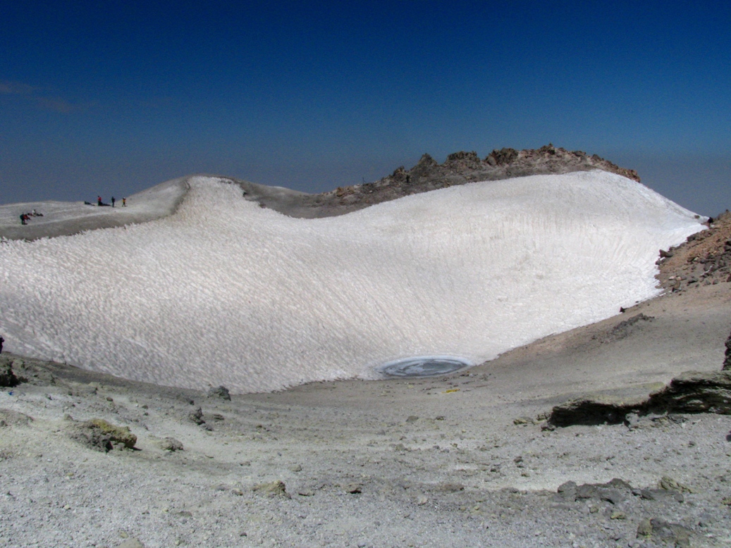
Glaciers
A few glaciers are present on the upper slopes of Damavand, the largest of which is Yakhar Glacier. During the Last Glacial Maximum, the area covered by glaciation was much larger and the climatic snow line was between 600 and below what is seen in the present day. The glaciers on Damavand as well as a few other isolated locations are the source of the few permanently flowing rivers in Iran.
Routes to the summit
A major settlement for mountain climbers is the new Iranian Mountain Federation Camp in the village of Polour, located on the southern side of the mountain.
There are at least 16 known routes to the summit, with varying levels of difficulty. Some of them are dangerous and require ice climbing. The most popular route is the southern route which has steps and a camp midway called Bargah Sevom Camp/Shelter at 4220 m. The Northeastern route is the longest and requires two days to reach the summit starting from the downhill village of Nāndal and a night stay at Takht-e Fereydoun (elevation 4300 m, a two-story shelter. The western route is noted for its sunset view. Simurgh (Sīmorgh/Sīmurgh) shelter in this route at 4100 m is a newly constructed two-story shelter. There is a frozen waterfall/icefall (Persian name Ābshār Yakhī) about 12 m tall.
Geography

Wildlife
Fish
Damavand's rivers have brown trout (Salmo trutta).
Mammals
Armenian mouflon (Ovis orientalis) and wild goat (Capra aegagrus) live in the region of Damavand Mts. Persian leopard (Panthera pardus saxicolor) and Syrian brown bear (Ursus arctos syriacus) also inhabit in this region. Smaller mammals include the snow vole (Chionomys nivalis), mouse-like hamster (Calomyscus bailwardi) and Afghan pika (Ochoton rufescens).
Birds
The Caspian snowcock (Tetraogallus caspius) lives at high altitudes. Golden eagle (Aquila chrysaetos) breeds in this area. Griffon vultures (Gyps fulvus) are common. Chukar partridge (Alectoris chukar) has a high population and nests between stone and shrubs. Red-fronted serin (Serinus pusillus), linnet (Carduelis cannabina), snow finch (Montifringilla nivalis), rock sparrow (Petronia petronia), rock bunting (Emberiza cia) and horned lark (Eremophila alpestris) are native; in winter they come to the lower hillsides. In spring northern wheatear (Oenanthe oenanthe), rock thrush (Monticola saxatilis), and nightingale (Luscinia megarhynchos) come from Africa for breeding. Grey-necked bunting (Emberiza buchanani), black-headed bunting (Emberiza melanocephala) and common rosefinch (Carpodacus erythrinus) come from India.
Reptiles and amphibians
Marsh frogs (Rana ridibunda) live in Lar riversides. Meadow viper (Vipera ursinii), blunt-nosed viper (Macrovipera lebetina), Iranian valley viper (Vipera latifii) and Caucasian agama (Laudakia caucasia) are among the reptiles of this mountainous region.
Flora

On the southern slope of Damavand, there are remnants of wild pistachio trees (Pistacia atlantica). Along its riversides different kinds of Salix trees like willow (Salix acomphylla) and oleaster (Elaeagnus angustifolia) are found. Greek juniper (Juniperus excelsa) is common in the higher altitudes. On northern slopes, because of higher humidity, there are wild oak, beech, hornbeam and hazel trees like: Persian oak (Quercus macranthera), Oriental beech (Fagus orientalis), Eastern hornbeam (Carpinus orientalis), and Turkish hazel (Corylus colurna). There are also many wild flowers such as mountain tulip (Tulipa montana) and Persian stone cress (Aethionema grandiflorum). At higher altitudes, shrubs tend to be sphere and cushion like, examples are : Astragalus species (Astragalus microcephalus), mountain sainfoin (Onobrychis cornuta) and prickly (Acantholimon erinaceum). Different kinds of grasses complete this alpine scene. Iris barnumiae demawendica (formerly Iris demawendica), is found and named after the mountain.
Festival
In 2007 the Iranian Cultural Heritage and Tourism Organization was in the process of renaming the Tirgan festival "Damavand National Day".
Gallery
File:030915-Damavand-Polour-IMG 3449-3.jpg|Damavand, Polour, December 2024 File:030915-Damavand-Polour-IMG 3449-4.jpg|Damavand, Polour, December 2024 File:030130-Polour-Damavand-IMG 5309-2.jpg|Mount Damavand File:981012-Damavand-South-IMG 9861-2.jpg|Mount Damavand, January File:990513-Damavand-IMG 4857-2.jpg|Damavand Summit File:990513-Damavand-IMG 4854-2.jpg|Damavand Summit, Lar Lake File:990512-Damavand-Sardagh-IMG 4818-2.jpg|Yaledagh, Mount Damavand File:Mount Damavand in sunrise - view from Tochal summit, Iran 2017.jpg|Damavand west side, view from Tochal summit File:نمای شهر تهران از بالا توسط هواپیما - panoramio.jpg|Aerial view of Tehran and Damavand
Explanatory notes
References
References
- [http://www.en.iran.ir/about/natural-regions Geography of Iran] {{webarchive. link. (2015-01-17)
- [https://commons.wikimedia.org/wiki/File:Txu-oclc-58750648-ni39-3.jpg 2009 U.S. military topographic mapping] gives {{convert. 18,365. ft. m
- "Kuh-e Damavand – Iran Ultra Prominence".
- {{cite pb
- [http://www.peakbagger.com/KeyCol.aspx?pid=10467 Pona, Georgia – Key col for Damavand] peakbagger.com. Retrieved 29 January 2016
- "SummitPost: Damavand".
- "Home".
- "Mountain Damavand".
- ''Microsoft Encarta World Atlas'', 2001, Microsoft Corporation
- [http://www.cbi.ir/default_en.aspx Central Bank of Iran]. Banknotes & Coins: [http://www.cbi.ir/page/1982.aspx 10000 Rials]. – Retrieved on 24 March 2009.
- (January 2015). "Crustal structure of Damavand volcano, Iran, from ambient noise and earthquake tomography". Journal of Seismology.
- (2021). "The Geology of Iran: Tectonic, Magmatism and Metamorphism".
- (January 1, 2004). "The geology of Damavand volcano, Alborz Mountains, northern Iran". Geological Society of America Bulletin.
- Geological Map of Iran, [[National Geoscience Database of Iran]], www.ngdir.ir
- {{cite gvp
- (March 2011). "Gravity-driven deformation of Damavand volcano, Iran, detected through InSAR time series". Geology.
- "ĀB-E GARM". Encyclopaedia Iranica Foundation.
- (February 2010). "Earthquake prediction activities and Damavand earthquake precursor test site in Iran". Natural Hazards.
- (June 2021). "A Comprehensive Assessment of Geomorphodiversity and Geomorphological Heritage for Damavand Volcano Management, Iran". Geoheritage.
- (2020). "Plant Biogeography and Vegetation of High Mountains of Central and South-West Asia".
- (2013). "The Economic Geology of Iran".
- "Map of Damavand".
- (17 August 2024). "Damavand Camps".
- (January 2026). "Mount Damavand Guides}}{{fv".
- "Damavand Icefall - Damavand Info".
- Mohammadian, H. Freshwater Fishes of Iran. Sepehr Publishing Center. Iran. 2000.
- Yazdani, A. Lar the Paradise I Knew. Payam Resan Publishing Institute. 2010.
- Lay, D.M. A Study of the Mammals of Iran (Resulting From the Street Expedition ). Field Museum of Natural History. Chicago .1967.
- Mohammadian, H. The Life of Alborz Red Sheep. Shabpareh Publishing Institute. 2008. {{ISBN. 978-600-5038-00-2.
- Mohammadian, H. Mammals of Iran. Shabpareh Publishing Institute. 2005. {{ISBN. 964-94487-9-9.
- Mohammadian, H. Mountain birds of Tehran. Shabpareh Publishing Institute. 2008. {{ISBN. 964-96358-9-0.
- Shahbazi, Y. Lar National Park Management Program. Natural Environment Department Library. 2004.
- Mohammadian, H. Reptiles and Amphibians of Iran. Shabpareh Publishing Institute. 2004. {{ISBN. 964-94487-2-1.
- Mozaffarian, V. Trees and Shrubs of Iran. Farhang Moaser Publishers. 2005. {{ISBN. 964-8637-03-2.
- Mozaffarian, V. Lar National Park Management Program. Natural Environment Department Library. 2004.
- Richard Lynch {{Google books. grvYTul5CSUC. The Book of the Iris (1904)
- "Newsletter October 2009, Iran Caspian to Kopet Dag". agscentralsussex.plus.com (The Alpine Garden Society).
- "Irna".
This article was imported from Wikipedia and is available under the Creative Commons Attribution-ShareAlike 4.0 License. Content has been adapted to SurfDoc format. Original contributors can be found on the article history page.
Ask Mako anything about Mount Damavand — get instant answers, deeper analysis, and related topics.
Research with MakoFree with your Surf account
Create a free account to save articles, ask Mako questions, and organize your research.
Sign up freeThis content may have been generated or modified by AI. CloudSurf Software LLC is not responsible for the accuracy, completeness, or reliability of AI-generated content. Always verify important information from primary sources.
Report