From Surf Wiki (app.surf) — the open knowledge base
Morecambe Bay
Estuary in northwest England
Estuary in northwest England
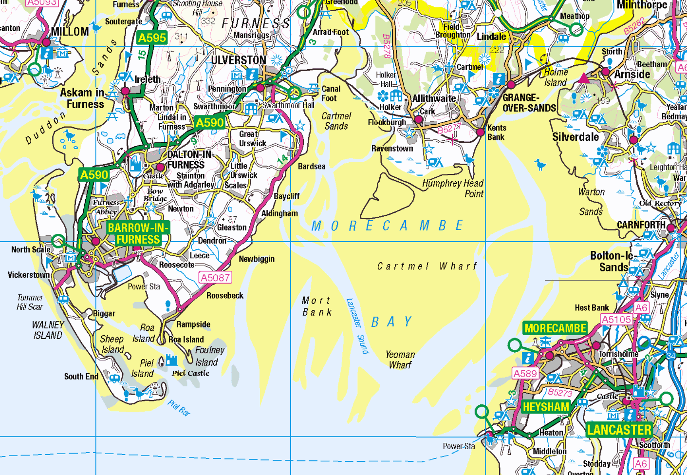
| [[File:Location map United Kingdom Morecambe Bay.svg|265px]] Map of Morecambe Bay | Show map of Morecambe Bay | {{Location map|England | Show map of England | {{Location map|Lancashire | Show map of Lancashire | {{Location map|Cumbria | Show map of Cumbria
Morecambe Bay is an estuary in north-west England, just to the south of the Lake District National Park. It is the largest expanse of intertidal mudflats and sand in the United Kingdom, covering a total area of 310 km2. In 1974, the second largest gas field in the UK was discovered 25 mi west of Blackpool, with original reserves of over 7 trillion cubic feet (tcf) (200 billion cubic metres). At its peak, 15% of Britain's gas supply came from the bay but production is now in decline. Morecambe Bay is also an important wildlife site, with abundant birdlife and varied marine habitats.
Natural features
The rivers Leven, Kent, Keer, Lune and Wyre drain into the Bay, with their various estuaries making a number of peninsulas within the bay. Much of the land around the bay is reclaimed, forming salt marshes used in agriculture. The bay is known for its wildlife populations, being a Special Area of Conservation, Special Protection Area and a Site of Special Scientific Interest, and there is a bird observatory at Walney Island. Some of the surrounding land is also a protected area, forming the Morecambe Bay Pavements, home to rare butterflies such as the high brown fritillary. The bay has rich cockle beds, which have been fished by locals for generations.
There are seven main islands in the bay, all to the west; Walney, Barrow, Sheep, Piel, Chapel, Foulney and Roa. Walney is substantially larger than the others, with its southern tip marking the north-western corner of the Bay. Sheep, Piel, Chapel and Foulney Islands are tidal and can be walked to at low tide with appropriate care. Local guidance should be sought if walking to Chapel or Piel islands as fast tides and quicksand can be extremely dangerous. Roa Island is linked to the mainland by a causeway, while Barrow Island has been connected to the mainland as part of the docks system at Barrow-in-Furness.
History
The extensive sandflats are the remains of a vast sandur or outwash plain established by meltwaters as the last ice age waned. Sea-level was still some 3m below present day levels at the start of the Holocene some 11,000 years ago.
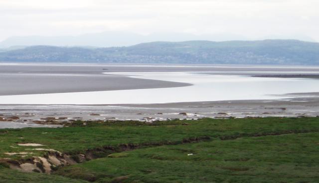
The Greek geographer and astronomer Claudius Ptolemy (died c170 AD) referred in his writings to Morikambe eischusis as a location on Britain's west coast, lying between the Ribble and the Solway. The sixteenth-century scholar William Camden identified the locality as being near Silloth, hence the similar name of that bay but the eighteenth century antiquarian John Horsley who translated Ptolemy into English in 1732 favoured it being the bay on the then Lancashire—Cumberland border. In 1771 historian John Whitaker took up this latter suggestion and the name appeared on maps subsequently. The first recorded to do so being one associated with Father Thomas West's Antiquities of Furness of 1774. Camden believed the name originated with two words meaning crooked sea whilst West offered up white/beautiful haven though current thought is that it refers to a curve of the sea.[[Image:Morecambe Bay Ulverston.JPG|thumb|Morecambe Bay from Ulverston]]
The bay has quicksand and fast moving tides. There have been royally appointed local guides (holding the post of King's Guide to the Sands) for crossing the bay for centuries; appointment of guides is now delegated to a trust. This difficulty of crossing the bay added to the isolation of the land to its north which, due to the presence of the mountains of the Lake District, could only be reached by crossing these sands or by ferry, until the Furness Railway was built in 1857. This skirts the edge of the bay, crossing the various estuaries. The London-Glasgow railway also briefly runs alongside the baythe only place where the West Coast Main Line actually runs alongside the coast.
The dangers presented by the bay were demonstrated in the 2004 Morecambe Bay cockling disaster when 23 illegal immigrants from China were drowned by an incoming tide, after being cut off while harvesting cockles. Criminal prosecution of the gangmaster and his associates for manslaughter and aiding immigration offences resulted in terms of imprisonment. These events were covered in a drama film and a non-fiction documentary. The incident has had a lasting effect on the community and estuary harvesting regulations.
Morecambe Bay is also home to several of the UK's offshore wind farms: West of Duddon Sands, Burbo Bank, Walney, Barrow, and Ormonde.
Population
Around 320,000 people live along the coastline of Morecambe Bay, with the largest town being Barrow-in-Furness to the west. Morecambe was once a popular seaside holiday destination, whilst Barrow still relies on the seas for a large percentage of its economy in ship and submarine construction.
| Town | County | Population |
|---|---|---|
| Barrow-in-Furness | Cumbria | 69,000 |
| Morecambe | Lancashire | 34,800 |
| Fleetwood | Lancashire | 25,900 |
| Ulverston | Cumbria | 11,200 |
| Heysham | Lancashire | 8,500 |
| Grange-over-Sands | Cumbria | 4,000 |
Natural gas

The bay has Britain's second-largest natural gas field, in the Triassic Sherwood Sandstone with a seal of Mercia Mudstone and a Carboniferous source. The North Morecambe Field, found in 1976, 8 mi to the north, is 11 mi2 and started production in 1994. Both are operated by Centrica Energy. They are 25 mi west of Blackpool in 30 metres of water; the top of the gas reservoir is at a depth of just 900 m, necessitating slant drilling for the first time in European waters. The combined gas reserves on discovery were estimated at 179 billion cubic metres (6.45 trillion cubic feet (tcf)). A further 0.65tcf is recognised in the satellite fields of Bains, Calder (Rivers), Dalton, Millom East and Millom West, and a number of smaller fields have been identified.
The gas is landed at three terminals at Westfield Point in Barrow-in-Furness, collectively referred to as the Rampside Gas Terminal.
At peak production 15% of UK supply came from the two main fields. as they are taxed at 62%. Production resumed from the South Morecambe field in July 2011.
Bridge and tidal barrage proposal
In 2004, a proposal was made to build a bridge across the bay flanked by wind turbines and using tidal power. Proposals from Northern Tidal Power Gateways in 2019 outlined a tidal barrage with a road running along on top.
Media{{anchor|coverage}}
- A brief article by David Cawley on the Morecambe Bay tidal crossing appeared in the September 2005 issue of Hidden Europe magazine.
- A fictionalised account of the Morecambe Bay cockling disaster was made into a 2006 drama film Ghosts by documentary maker Nick Broomfield; Channel 4's documentary series The Other Side commissioned a factual work from a local Cumbrian filmmaker on the same events.
- The crime drama television series The Bay is set in and around Morecambe Bay, and derives its name from the location. Location filming for the series was shot around the area.
- A book about the bay, The Gathering Tide: A Journey Around the Edgelands of Morecambe Bay (2016) by environmentalist Karen Lloyd, is a memoir of a year spent walking the coast, involving social history, archaeology and local wildlife.
References
References
- "Morecambe Bay".
- "Morecambe Bay {{!}} Ramsar Sites Information Service".
- (2011). "No Boat Required – Exploring Tidal Islands". Matador – Troubador.
- "Arnside & Silverdale : Area of Outstanding Natural Beauty : Special Qualities Report".
- (1985). "The Geomorphology of North-west England". Manchester University Press.
- Eilert Ekwall, ''Concise Oxford Dictionary of English Place Names'', Oxford University Press.
- "Where does the name Morecambe Bay come from?".
- (12 April 2019). "Sands of time run out for Queen's Guide to Morecambe Bay". The Guardian.
- "Guides Crossing the Bay Since 1548".
- (30 November 2010). "Coroner records unlawful killing verdict on Morecambe Bay cockler". The Westmorland Gazette.
- (3 February 2014}}). "Morecambe Bay cockling disaster's lasting impact". HSE Media Centre.
- "Check Browser Settings". statistics.gov.uk.
- (2012). "Oil and Gas from the Western Basins". United Kingdom Offshore Oil and Gas Industry Association.
- (1 January 1991). "The South Morecambe Field, Blocks 110/2a, 110/3a, 110/8a, UK East Irish Sea". Geological Society, London, Memoirs.
- ((Centrica)). "Hydrocarbon Resources Limited Morecambe Bay Environmental Statement 2006".
- (28 December 2006). "Six dead in rig helicopter crash". BBC News.
- Wachman, Richard. (1 May 2011). "Centrica threatens to shut down Morecambe Bay gas field". [[The Guardian]].
- "Centrica restarts mothballed Morecambe Bay gas field".
- (21 August 2005). "UK: Morecambe Bay bridge could power 2.2 million homes".
- (18 May 2004). "Morecambe Bay bridge considered". BBC News.
- (13 June 2007). "Has the tide turned in bay bridge debate?". [[The Mail (Cumbria).
- (30 November 2019). "Barrow would be 'killed' by barrage bridge to Heysham". BBC News.
- Taylor, Dan. (2 August 2020). "Morecambe Bay Bridge plan ready to take next step to get Government backing". The Westmorland Gazette.
- (September 2005). "Time and Tide: Morecambe Bay".
- (12 January 2007). "Review: ''Ghosts''". The Guardian.
- (20 March 2019). "''The Bay'', episode 1, review: Can this crime drama be anything more than a northern ''Broadchurch''?". The Telegraph.
- (20 March 2019). "Armagh writer Daragh Carville talks about his new ITV crime drama ''The Bay''". The Irish News.
- Lloyd, Karen. (2022). "The Gathering Tide: A Journey Around the Edgelands of Morecambe Bay". Saraband.
This article was imported from Wikipedia and is available under the Creative Commons Attribution-ShareAlike 4.0 License. Content has been adapted to SurfDoc format. Original contributors can be found on the article history page.
Ask Mako anything about Morecambe Bay — get instant answers, deeper analysis, and related topics.
Research with MakoFree with your Surf account
Create a free account to save articles, ask Mako questions, and organize your research.
Sign up freeThis content may have been generated or modified by AI. CloudSurf Software LLC is not responsible for the accuracy, completeness, or reliability of AI-generated content. Always verify important information from primary sources.
Report