From Surf Wiki (app.surf) — the open knowledge base
Money Island, Paracel Islands
Island in the South China Sea
Island in the South China Sea
| Field | Value |
|---|---|
| name | Money Island |
| coordinates | |
| pushpin_map | South China Sea |
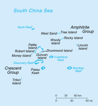
Money Island (; ) is the southwesternmost island in the Crescent Group of the Paracel Islands archipelago. It rises to a height of 6 metres and is covered with brush. At the eastern side of the island lies an extensive reef, which contains a central lagoon, but the reef is mostly submerged at high tide. Inside the lagoon, the open areas range in depth from 7 to. The sand cay at the southeastern extremity of reef is the reef's highest point. The channel between Money Island's reef and Antelope Reef is about 1.5 mi wide. The reef continues around to the north side of the island. There is a small reef on the south side with a man-made channel cut through it to the beach.
Money Island was named after William Taylor Money, the superintendent of the Bombay Marine from 1803 to 1810. The name was conferred by the British naval officer and hydrographer Captain Daniel Ross, who surveyed the Paracel Islands. Ross's ship, Antelope, gave its name to the nearby Antelope Reef. The Chinese names (e.g. Jin Yin Dao for Money Island) are simple translations of the English names. The Vietnamese name Quang Ảnh dates from 1815 when the commander Phạm Quang Ảnh led the expedition to the islands in the reign of Emperor Gia Long.
Claim to the island, as part of the Paracels, has been made by the Republic of China (Taiwan) and Vietnam. While the island is uninhabited, patrols are made by the Navy of the People's Republic of China, who have built a fisherman's rest area there. It is believed that the south channel was cut by Chinese naval personnel.
References
References
- "Money Island (Approved)" {{GEOnet2. 32FA8831BE2E3774E0440003BA962ED3, [[National Geospatial-Intelligence Agency. United States National Geospatial-Intelligence Agency]]
- link. (May 14, 2014 Published online in Vietnamese on January 30th, 2011, by the National Committee for Border Affairs, Ministry of Foreign Affairs, Socialist Republic of Viet Nam, translated by Nguyễn Trịnh Đôn, Southeast Asian Sea Research Foundation)
- [[National Imagery and Mapping Agency]] (2002) [http://permanent.access.gpo.gov/websites/pollux/pollux.nss.nima.mil/NAV_PUBS/SD/pub161/161sec01.pdf "South China Sea and the Gulf of Thailand – Central Part: Paracel Islands"] ''Sailing Directions (enroute): South China Sea and the Gulf of Thailand'' (8th edition) [[National Imagery and Mapping Agency]], Bethesda, Maryland, {{OCLC. 50280301
- "MONEY, William Taylor (1769-1834), of Walthamstow, Essex. | History of Parliament Online".
- Sơn Hồng Đức. "Thử khảo-sát về Quần-đảo Hoàng-sa". ''Sử Địa'' XX, 29, 1975. pp 190-2
- [http://hoangsa.org/gallery/showphoto.php?photo=10019 "Hình ảnh nhà trên đảo Quang Ảnh do TQ xây cho ngư dân nghỉ ngơi" ("Photo Money Island Fisherman's Rest built by China")] Trung tâm Dữ liệu Hoàng Sa (Data Center for Paracel Islands)
This article was imported from Wikipedia and is available under the Creative Commons Attribution-ShareAlike 4.0 License. Content has been adapted to SurfDoc format. Original contributors can be found on the article history page.
Ask Mako anything about Money Island, Paracel Islands — get instant answers, deeper analysis, and related topics.
Research with MakoFree with your Surf account
Create a free account to save articles, ask Mako questions, and organize your research.
Sign up freeThis content may have been generated or modified by AI. CloudSurf Software LLC is not responsible for the accuracy, completeness, or reliability of AI-generated content. Always verify important information from primary sources.
Report