From Surf Wiki (app.surf) — the open knowledge base
Mani Peninsula
Geographical and cultural region in Greece

Geographical and cultural region in Greece
| Field | Value |
|---|---|
| name | Mani |
| type | Peninsula |
| photo | Greece_Mani_Peninsula_labeled.gif |
| photo_caption | Location of the Mani Peninsula |
| map | Greece |
| map_relief | 1 |
| mapframe | yes |
| mapframe-zoom | 5 |
| mapframe-point | none |
| mapframe-height | 250 |
| label_position | none |
| location | Peloponnese, Greece |
| free_label_1 | Municipalities |
| free_data_1 | East Mani, West Mani |
| free_label_2 | Population (2021) |
| free_data_2 | 18,654 |
| mapframe-zoom = 5 | mapframe-point = none | mapframe-height = 250 | volcanic_arc/belt =
The Mani Peninsula is a geographical and cultural region of the Peloponnese in southern Greece. It is often referred to as Mani () or "the Mani". The inhabitants of Mani are known as Maniots (Mανιάτες, el). Mani and the Maniots played a key role in the Greek War of Independence that began in 1821. |author-link=Mark Mazower
The Mani is the central of the three peninsulas extending southwards from the Peloponnese into the Mediterranean Sea. To Mani's east lie the Laconian Gulf and the peninsula of Cape Maleas, and to its west, the Messenian Gulf and the peninsula of Messenia. The Mani Peninsula is the southern extension of the Taygetus mountain range. It is about 45 km long, with a rocky, rugged, interior bordered by scenic coastlines. Mani terminates at Cape Matapan, the southernmost point of continental Greece.
In ancient times, Mani was considered part of Laconia, a region dominated by the powerful city-state (polis) of Sparta. Its administration is now divided between the municipalities of East Mani in modern Laconia, and West Mani in Messenia. Mani's towns include Areopoli, Gytheio, and Pyrgos Dirou. Notable sites in Mani include the ruins of the ancient Temple of Poseidon at Cape Matapan, the Monastery of Panayia Yiatrissa, and the Apidima Cave with its Neanderthal fossils.
Mani was known as el () for its numerous tower-houses. From 1978 onwards, the Greek state decreed many settlements with tower-houses "traditional", setting restrictions on construction. In 2003, the whole peninsula was designated a "cultural complex of international importance". |trans-title=The historic residential landscape of Mani |url-status=live |archive-url=https://web.archive.org/web/20250212150742/https://www.greekscapes.gr/index.php/2010-01-21-16-47-29/landscapescat/65-2009-07-31-09-50-02/76-mani |archive-date=12 February 2025 |access-date=6 October 2025}} For an example of a decree designating specified settlements as traditional, see |trans-title=Presidential Decree 20-10-1998: Characterization of settlements in the Prefecture of Laconia as traditional and determination of special conditions and restrictions for their construction (Government Gazette 912/D/1998) |url-status=live |archive-url=https://web.archive.org/web/20251006212441/https://www.nomoskopio.gr/index.html?pd_20_10_98.php |archive-date=6 October 2025 |access-date=6 October 2025}}
Name
The origin of the name "Mani" is uncertain.{{refn|group=lower-alpha|Speculative explanations include its derivation from μανία, grc; from the Albanian word for mulberry tree, manit; and from the adjective μανός, grc . |trans-title=History of Mani: AncientMedievalModern |trans-chapter=The name Mani |title-link=Oxford Dictionary of Byzantium |editor-first=Alexander |editor-last=Kazhdan |entry-url=https://archive.org/details/oxforddictionary0003unse_j5n1/page/2007/mode/1up |author-link=Alexander Kazhdan |entry-url-access=registration |access-date=17 December 2025 |trans-journal=Theology |trans-title=The earliest mention of Maina and its diocese |author-link=:el:Γεράσιμος Κονιδάρης |access-date=17 December 2025
The 14th-century Greek-text version of the Chronicle of Morea narrates how William of Villehardouin, ruler of the Principality of Achaea (), journeyed εἰς τὴν Μάνην (grc-x-medieval, ) and built a castle he named Μάνη (grc-x-medieval, ) on a promontory there. The castle is more usually known as Grand Magne.
Ecology
The Mani is in the Aegean and Western Turkey Sclerophyllous and Mixed Forests ecoregion, |access-date=15 January 2026
Governance
The southern part of the peninsula, covering about 317 km2, is a Special Protection Area (SPA) within the Natura 2000 network. This SPA was designated in 2010 under the Birds Directive of the European Union; it protects 72 bird species. |access-date=15 January 2026 |access-date=15 January 2026
Geology
Main article: Taygetus#Geology
The Mani is a peninsula with Cape Matapan forming its southern tip. The massif of the Taygetus range, about 100 km long, extends from the centre of the Peloponnese to Cape Matapan. The peninsula is composed of Mesozoic-era carbonate rocks, such as limestone, which erode to form karst caves such as the one at Alepotrypa. |editor1-first=J. |editor1-last=Harff |editor2-first=G. |editor2-last=Bailey |editor3-first=F. |editor3-last=Lüth |author2-link=:el:Νένα Γαλανίδου |chapter-url=https://www.researchgate.net/publication/279848495 |access-date=14 November 2025
Shallow lithosols and rendzina soils, with a low capacity for holding water, dominate on limestone bedrock. Terra rossa (Italian for 'red soil'), a water-retentive, clayey soil with a deeper profile, is common in cultivated areas. Alluvial soils are found in river valleys, and saline soils in coastal environments. |orig-date=2016|edition=2nd
The tallest mountain in the Taygetus range is Mount Taygetus. Its summit, el (Προφήτης Ηλίας ), stands at 2404 m, and is the highest in the Peloponnese. |access-date=15 November 2025 |author1-link=Helen Waterhouse |author-link=Pausanias (geographer)
Land cover and vegetation
Vegetation in the Mani occupies a range of natural, semi-natural and human-made habitats with a high diversity of species.
Communities of low-growing alpine plants thrive above the tree line of the Taygetus range: examples are Clinopodium alpinum (rock thyme); Astragalus angustifolius (a species of milkvetch); and the rare Jurinea taygetea, an endemic species in the Jurinea genus. Montane forests dominated by Abies cephalonica (Greek fir) and Pinus nigra (European black pine) occur at moderate elevations.
Maquis, a type of impenetrable scrubland made up of evergreen, hard-leaved shrubs about 1.5 – tall, is widespread on lower mountain slopes. Typical species are Arbutus unedo (strawberry tree), Pistacia lentiscus (mastic), Quercus coccifera (kermes oak), and Smilax aspera (a species of vine). Garrigue, a more open vegetation type, is also found over large areas at lower altitudes. This habitat features aromatic, shrubby plants, usually less than 1 m high, such as Sarcopoterium spinosum (spiny burnet), Euphorbia acanthothamnos (Greek spiny spurge), Thymus capitatus (conehead thyme), and Anthyllis hermanniae (lavender-leaved anthyllis). Olive groves on the lower slopes (often terraced) and in the coastal plain of Messenian Mani are mainly cultivated without the use of herbicides; the groves provide habitats for many spring-flowering annual plants.
The Vyros Gorge hosts several endemic species, including Lithodora zahnii of the genus Lithodora, and Thalictrum orientale (a type of meadow-rue).
Mani's rocky shores and sandy beaches, a specific habitat, feature plants such as Matthiola sinuata (sea stock), Limonium sinuatum (sea lavender), and Pancratium maritimum (sea daffodil). Posidonia oceanica (Neptune grass) is found offshore.
Climate
The Mani peninsula, like much of southern Greece, has a hot-summer Mediterranean climate (Köppen climate classification Csa) |archive-date=3 December 2019 |archive-url=https://web.archive.org/web/20191203232232/http://www.hnms.gr/emy/en/climatology/climatology |url-status=unfit |access-date=15 January 2026 |archive-url=https://web.archive.org/web/20170921184739/http://www.hnms.gr/hnms/greek/pdf/Climate_Atlas_Of_Greece.pdf |url-status=unfit |archive-date=21 September 2017 |access-date=15 January 2026 |url-access=subscription
Local government and services
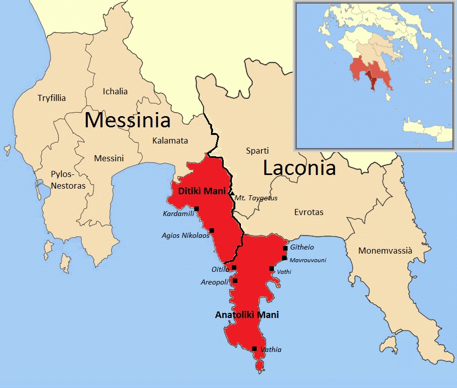
Local government is provided by the municipalities of West Mani (Δυτική Μάνη, el), and East Mani (Ανατολική Μάνη, el). Each municipality is headed by a mayor, who governs with the aid of a municipal council.West Mani: Δημοτικό Συμβούλιο [Municipal Council] (in Greek). Δήμος Δυτικής Μάνης [Municipality of West Mani]. n.d. East Mani: Δημοτικό Συμβούλιο [Municipal Council] (in Greek). Δήμος Ανατολικής Μάνης [Municipality of East Mani]. n.d. Retrieved 21 November 2025.
West Mani, with its administrative seat in Kardamyli, is part of the regional unit of Messenia; East Mani, whose administrative seat is Gytheio, is in Laconia.
Messenia and Laconia are within the Peloponnese administrative region.
Traditional regions
The three traditional regions of Mani are:
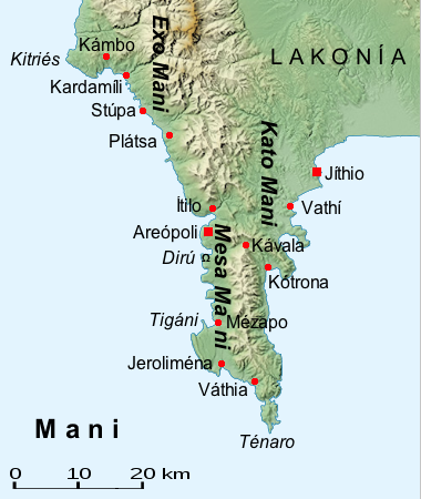
- Outer Mani (Έξω Μάνη, el) in the northwest, corresponding approximately to West Mani;
- Lower Mani (Κάτω Μάνη, el) in the east, corresponding approximately to northern East Mani;
- Inner Mani (Μέσα Μάνη, el) in the southwest, corresponding approximately to southern East Mani.
Cranae, an island just off the coast of Gytheio in Lower Mani, was linked to the mainland by a causeway in 1898.
Media
Local newspapers covering events in Mani include:
- Lakonikos, an online newspaper focused on Laconia;
- Messinia Press, an online newspaper with a section on West Mani;
- Notos Press, an online newspaper covering the Peloponnese Region;
- Θάρρος (el ), a daily print and online newspaper focused on Messenia, with a section on West Mani.
Transport links
Roads
A winding road with coastal stretches links Kalamata, via Kampos, Kardamyli and Stoupa, to Oitylo, from where a cross-peninsular road runs northeast to Gytheio. |access-date=29 November 2025 |access-date=29 November 2025
From Gytheio, National Road 39 (European route E961) runs north to Sparta. |access-date=29 November 2025 |access-date=29 November 2025
Paths
The Peloponnese section of the E4 European long-distance path runs via Sparta and Kastania to Gytheio in northeast Mani, and then continues, via ferry, in Crete. |access-date=29 November 2025
Ferries
Ferries connect Gytheio to Kythera, Antikythera, Crete, and Piraeus, the port of Athens. |access-date=20 November 2025
Airport
Kalamata International Airport is near Kalamata, which is adjacent to West Mani.
Towns and settlements
Modern
- Agios Nikolaos
- Altomira
- Areopoli
- Avia
- Doloi
- Drosopigi
- Dryalos
- Gerolimenas
- Gytheio
- Kalyvia
- Kampos
- Kardamyli
- Kastania
- Kelefa
- Kipoula
- Koita
- Lefktro
- Mavrovouni
- Megali Mantineia
- Myrsini
- Oitylo
- Parasyros
- Petrovouni
- Porto Kagio
- Pyrgos Dirou
- Skoutari
- Sminos
- Stoupa
- Vatheia
Ancient
- Asine
- Caenepolis (or Kainepolis)
- Gerenia
- Gytheion, Gythium (modern Gytheio)
- Hippola
- Kardamyli
- Las
- Leuctra
- Messa
- Oetylus (modern Oitylo)
- Psamathus
- Pyrrichos
- Taenarum
- Teuthrone
- Thalamae
Notable sites and features
- Alepotrypa Cave
- Apidima Cave
- Beaufort Castle
- Cape Matapan
- Diros Caves
- Grand Magne Castle
- Kalamakia Cave
- Kelefa Castle
- Monastery of Panayia Yiatrissa
- Mount Taygetus
- Passavas Castle
- Porto Kagio
- Temple of Poseidon at Tainaron
- Tigani Peninsula
- Vatheia
- Vyros Gorge
- Zarnata Castle
History
Prehistory
Palaeolithic to Neolithic
Mani has been inhabited since prehistoric times. The Apidima Cave on the west side of the peninsula has yielded Neanderthal and Homo sapiens fossils from the Palaeolithic era. |author-link=:de:Eric Delson |display-authors=etal |author1-link=Katerina Harvati |display-editors=et al |editor1-first=A. |editor1-last=Papathanasiou |editor2-first=W. A. |editor2-last=Parkinson |editor3-first=D. J. |editor3-last=Pullen |chapter-url=https://www.academia.edu/67855851 |chapter-url-access=registration |access-date=6 November 2025 |display-authors=etal |author1-link=Katerina Harvati |doi-access=free |orig-date=2018 |display-authors=etal |author3-link=:de:Panagiotis Karkanas
Evidence of extensive Neolithic and early Bronze Age occupation and activity extending north and south of the Bay of Oitylo has been found at many other cave sites. |chapter-url=https://www.bsa.ac.uk/videos/stella-katsarou-and-andreas-darlas-new-evidence-on-neolithic-burial-and-occupation-practices-in-the-coastal-caves-of-the-mani-laconia/
Mycenaean
The Mycenaean civilization (1900–1100 BC) dominated Mani and the Peloponnese in the Bronze Age. Mani flourished under the Mycenaeans. A temple dedicated to Apollo was erected at Cape Matapan. It was later re-dedicated as the Temple of Poseidon. Homer refers to a number of towns in the Mani region. The "Catalogue of Ships" in the Iliad names Messa, Oetylus, Kardamyli, Gerenia, Teuthrone, and Las. Mani features in many myths and legends, with one describing a sea-hollowed cavern near Cape Matapan (ancient Taenarum) as a portal to Hades, the underworld. |author-link=Paul J. Kosmin
Ancient Mani
Dark Ages
In the early Greek Dark Ages (c. 1050–800 BC), the inhabitants of Laconia were leading producers of Tyrian purple from the murex sea snail, still plentiful in the waters off Gytheio and Kythera. Production is thought to have been established by the Phoenicians. |author-link=Paul Cartledge |access-date=17 December 2025
Archaic
With the onset of the Archaic Period (480 BC), Mani and much of the Peloponnese came under the sway of the powerful city-state of Sparta. Under Spartan rule, the inhabitants of Kardamyli, Thalamae, Gythium, and other poleis in Laconia and Messenia, were second-tier citizens known as el, . |url-access=registration |access-date=30 November 2025
Classical
Gytheio, 27 km from Sparta, became Mani'sand Sparta'smajor port. It was captured by Athenian forces in 455 BC during the First Peloponnesian War, a power struggle between Athens and Sparta and their respective allies.
The damaged city and docks were rebuilt; by the end of the war, Gytheio was the main shipyard for the new Spartan fleet. Spartan hegemony in the Peloponnese lasted until 371 BC, when the Thebans under Epaminondas defeated Sparta at the Battle of Leuctra. |quote-page=34 |access-date=31 October 2025
Hellenistic
Throughout much of the Hellenistic period (323–30 BC), the Mani Peninsula remained subject to Spartan hegemony. This era proved turbulent for Mani and Laconia, marked by frequent military engagements and shifting political allegiances. Taenarum became a mercenary headquarters in the late 4th century. |title-link=Oxford Classical Dictionary |display-editors=etal |editor1-first=Simon |editor1-last=Hornblower |entry-url=https://archive.org/details/oxfordclassicald0000unse_w0c8/page/1428/mode/1up |display-authors=etal |access-date=31 October 2025
Competition between rival powers resulted in a series of wars that eventually drew in the Kingdom of Macedon and the expanding Roman Republic: the Cleomenean War (229–222 BC); the Social War (220–217 BC); the Macedonian Wars (214–148 BC); and the Laconian War (195 BC). Gythium, as a major port, remained an especially sought-after prize for all parties.
In 218 BC, during the Social War, Philip V of Macedon invaded and overran Laconia. In the process, he laid waste the east coast of the Mani Peninsula as far south as Taenarum, though he failed to capture Asine. Reversing course northwards, he headed for Gythium, and then made for Helos and the Malea peninsula, which he devastated as far south as Boeae. |author-link=F. W. Walbank |section-url=https://archive.org/details/historicalcommen0001fwwa/page/553/mode/1up |url-access=registration |access-date=8 January 2026 |author-link=Polybius |translator-first=W. R. |translator-last=Paton |translator-link=William Roger Paton |chapter-url=https://archive.org/details/in.ernet.dli.2015.185452/page/49/mode/2up |orig-date=c. 150 BCE |access-date=8 January 2026
Nabis ascended to the Spartan throne in 207 BC; he expanded Gythium, transforming it into a naval base. |author-link=Peter Green (historian) |url-access=registration |access-date=22 October 2025 |title-link=Pauly encyclopedias#New Pauly |author-link=Karl-Wilhelm Welwei
Determined to retake Gythium, Nabis advanced on and recovered the port in 192 BC. The Romans soon recaptured it. Nabis was assassinated, and Sparta was incorporated, on lenient terms, in the Achaean League. In 189 BC, the Spartans, still seeking access to a port, seized Las, prompting the Achaeans to abolish the Spartan constitution, end social institutions such as the education and training system (grc) and mess halls, and absorb Sparta outright. |author1-link=Paul Cartledge |chapter-url=https://books.google.com/books?id=3ctrjKOFoWgC&pg=PA70 |access-date=30 October 2025
Roman

|author-link=Pausanias (geographer) With the victory of the Romans over Corinth and the Achaean League at the Battle of Corinth in 146 BC, all of Greece became part of their empire. |author-link=P. J. Rhodes |access-date=14 October 2025 |editor1-first=F. W. |editor1-last=Walbank |editor1-link=F. W. Walbank |editor2-first=A. E. |editor2-last=Astin |editor3-first=M. W. |editor3-last=Frederiksen |editor4-first=R. M. |editor4-last=Ogilvie |editor4-link=Robert Maxwell Ogilvie |chapter-url=https://archive.org/details/the-cambridge-ancient-history-vol.-8/page/319/mode/2up |author-link=Peter Derow |access-date=17 October 2025 |display-authors=etal |author2-link=Nicholas Ambraseys |editor-first=Avner |editor-last=Raban |chapter-url=https://www.ancientportsantiques.com/wp-content/uploads/Documents/PLACES/GreecePeloponnesus/Gythion-Scoufopoulos1985.pdf |url-status=live |access-date=31 October 2025 |archive-url=https://web.archive.org/web/20251031135509/https://www.ancientportsantiques.com/wp-content/uploads/Documents/PLACES/GreecePeloponnesus/Gythion-Scoufopoulos1985.pdf |archive-date=31 October 2025
In 395 AD, mainland Greece and the Peloponnese became part of the Byzantine Empire (also known as the Eastern Roman Empire), bringing over 500 years of centralized rule from Rome to an end. Mani would nominally be administered by the new government in Constantinople for over a millennium, with periodic interruptions due to unrest and foreign invasions. Mani's remoteness would limit Constantinople's influence.
Middle Ages
Byzantine rule
The Mani Peninsula had a turbulent history during the long period of Byzantine Greece (395–1453), as various powers fought over it and the whole Peloponnese (known for much of this time as "Morea"). Between 396 and 397, the Visigoths under Alaric I raided the Peloponnese. |author-link=Michael Kulikowski
In the late 6th century, Avars and Slavs invaded Greece, reaching much of the Peloponnese. |title-link=Oxford Dictionary of Byzantium |editor-first=Alexander |editor-last=Kazhdan |editor-link=Alexander Kazhdan |entry-url=https://archive.org/details/oxforddictionary0003unse_j5n1/page/1620/mode/1up |author-link=Timothy E. Gregory |entry-url-access=registration |access-date=27 October 2025 |title-link=Oxford Classical Dictionary |display-editors=etal |editor1-first=Simon |editor1-last=Hornblower |entry-url=https://archive.org/details/oxfordclassicald0000unse_w0c8/page/215/mode/1up |author-link=Michael Whitby |access-date=2 November 2025 |author-link=John Van Antwerp Fine Jr. |section-url=https://archive.org/details/earlymedievalbal0000fine/page/58/mode/2up |url-access=registration |access-date=2 November 2025 |display-authors=etal |author1-link=George Stamatoyannopoulos |quote-page=637
Over the subsequent centuries, Mani was fought over by the Byzantines, the French, and the Saracens. In the wake of the Early Muslim conquests, Arabs captured the island of Crete in the 820s and established an emirate there. Arab pirates then began to raid Mani and the coastal cities of the Peloponnese; this ceased when the Byzantines retook Crete in 961. |title-link=Encyclopaedia of Islam |display-editors=etal |editor1-first=C. E. |editor1-last=Bosworth |editor1-link=Clifford Edmund Bosworth |editor2-first=E. |editor2-last=van Donzel |editor2-link=Emeri van Donzel |entry-url=https://archive.org/details/ei2-complete/Encyclopaedia_of_Islam_vol_7_Mif-Naz/page/236/mode/1up |author1-link=:el:Αλέξιος Γ.Κ. Σαββίδης |author2-link=:el:Νίκος Βέης |access-date=27 October 2025
Christianization
By the middle of the 6th century, mainland Greece was largely Christianized: there were nearly 60 episcopal sees, with a large concentration in the Province of Achaia, of which Mani was a part. |author-link=Florin Curta |author-link=Constantine VII |editor-first=Gyula |editor-last=Moravcsik |editor-link=Gyula Moravcsik |translator-first=Romilly |translator-last=Jenkins |translator-link=Romilly Jenkins |trans-title=On Administering the Empire |orig-date=c. 950 |url-access=registration |quote-page=237 |access-date=3 December 2025
According to Seifried (2021), |editor-first=Joanne M. A. |editor-last=Murphy |hdl-access=free
Concerning the possible role of St. Nikon in Mani's Christianizationhe was active as a missionary in mainland Greece from the mid-960sCurta (2011) states that "In Peloponnesos, Nikon does not appear to have been concerned with the conversion of anyone, either Greek or Slav."
Crusader states
After the Sack of Constantinople in 1204 during the Fourth Crusade, the Mani Peninsula became part of the Principality of Achaea (12051432), a Crusader state, though it retained a degree of autonomy due to its largely inaccessible mountain terrain. |trans-title=The Frankish Morea: Historical, Topographic and Archaeological Studies of the Principality of Achaea (12051430) |access-date=3 November 2025
The Melingoi, a Slavic tribe, had settled on the western side of the Taygetus between the 6th and 9th centuries. |trans-title=Slavic Settlement in the Peloponnese on the Basis of Slavic Place-Names |access-date=8 December 2025 |title-link=Oxford Dictionary of Byzantium |editor-first=Alexander |editor-last=Kazhdan |editor-link=Alexander Kazhdan |entry-url=https://archive.org/details/oxforddictionary0002unse_e8n1/page/1334/mode/2up |author-link=Omeljan Pritsak |entry-url-access=registration |access-date=9 December 2025
By the mid-13th century, the resurgence of the Byzantine Empire under the Palaiologos dynasty had shifted the balance of power in Greece. In the 1250s the Pope appointed a "Latin," i.e., Roman Catholic, bishop to Mani, provoking resentment among the Orthodox Greeks, who soon removed him. In 1259, Byzantine forces captured Prince William at the Battle of Pelagonia. In 1262, William surrendered three fortresses to Emperor Michael VIII to obtain his release: Mystras, Grand Magne, and Monemvasia. |author-link=Kenneth Setton |access-date=6 November 2025
Byzantine Despotate
Maniots had maintained a significant degree of autonomy during the Principality of Achaea's existence. From the mid-14th to mid-15th centuries, control over the region gradually shifted to a semi-autonomous province of the Byzantine Empire called the Despotate of the Morea (1349–1460), when successive despotes governed the province.
Ottoman rule
In 1453, the Ottoman Empire besieged and captured Constantinople; by 1460, the Ottomans had completed their conquest of the Morea.
The Ottomans remained nominal rulers of Mani until the outbreak of the Greek War of Independence in 1821, with a brief interlude of Venetian control. Mani was first administered by the Ottoman Eyalet of the Archipelago, and then by the Morea Eyalet. As an area with a challenging topography, a demanding environment, and on the margins of the empire, imperial control of Mani was limited; this allowed some local independence in determining social structures and political arrangements. |editor-first=Alexis |editor-last=Wick |author1-link=Isa Blumi
Ottoman-Venetian wars
The Ottoman Empire and the Republic of Venice frequently clashed over control of the Morea, with the Mani Peninsula emerging as a major site of contestation during a series of conflicts that began in 1396about sixty years before the Ottoman conquest of Greeceand ended in 1718. A significant shift in the balance of power occurred with the Treaty of Constantinople (1479), a Venetian-Ottoman peace settlement ending the First Ottoman–Venetian War, which had begun in 1463. The treaty restored territorial boundaries to their pre-1463 status. This meant that lands held by Greek rebels under Venetian protection returned to Ottoman control, including the Mani Peninsula.
Krokodeilos Kladas (14251490) had led bands of warriors called stratioti against the Ottoman Empire, with Venice providing support. |access-date=28 October 2025 |display-editors=etal |editor1-first=Susanna |editor1-last=Burghartz |editor1-link=:de:Susanna Burghartz
Around 1568, the Ottomans built a small castle to defend the harbour of Porto Kagio, which they were using as a base for galleys patrolling the Kythira Strait between the Peloponnese and Crete. They abandoned it in 1570 after a Venetian attack. Certain 17th- and 18th-century cartographers refer to the castle as "Maina"; some later authors identified this as the 13th-century Grand Magne, though medieval portolan charts do not show a castle there. |access-date=29 October 2025
1612 Ottoman incursion
In 1612, the Mani Peninsula became the focal point of another Ottoman military incursion, this time triggered by the actions of Charles Gonzaga (1580–1637), who claimed descent from the Palaiologos dynasty. Charles sought to establish a new Byzantine state with himself as emperor in Constantinople, viewing his endeavor as a new crusade. The Maniots caught wind of Charles's ambitions and negotiated an alliance, with church leaders addressing him as "Constantine Palaeologus". |author-link=William Miller (historian)
On discovering Charles's plans and the Maniots' support, the Ottoman authorities launched a large-scale punitive expedition, with a force of 20,000 soldiers and 70 ships deployed to invade Mani. The Ottomans devastated the peninsula and imposed punishing taxes on the Greeks. Charles's further attempts at his crusade failed, and he later became Duke of Mantua and Montferrat. His failure left the Maniots to continue their struggle against the Ottomans without external support. The Maniots' resistance remained a persistent challenge to Ottoman authority. |author-link=Guy Stair Sainty |access-date=19 October 2025
Piracy
Maniot piracy was observed by the Turkish explorer Evliya Çelebi (1611–1682), who visited Mani with an Ottoman expedition. He said of the Maniots: "They capture the Frank and sell him to us, they capture us and sell us to the Franks." |trans-title=A wise man of the world, Stefanos Yerasimos, 19422005 |display-editors=etal |editor-first=Edhem |editor-last=Eldem |editor-link=Edhem Eldem |trans-chapter=Greece in Evliya Çelebi's Travelogue: Routes and Itineraries |access-date=24 November 2025 |doi-access=free
Migrations to Corsica
In October 1675, some 730 Maniots fleeing Ottoman rule embarked from Oitylo on a Genoese ship for Corsica, which was then Genoese territory. After a short stop in Genoa, they arrived in Corsica in March 1676, eventually settling in the area of Paomia (modern Cargèse). These settlers, led by the Stephanopoulos family and accompanied by clergy, were the first wave of a significant Greek migration to the island. |hdl-access=free
Beys of Mani
In the late 17th century, the Ottomans began appointing Maniot chieftains, designated beys, to rule Mani on their behalf. The rule of the Beys of Mani ended with the onset of the Greek War of Independence in 1821.
The first such bey was the Maniot Limberakis Gerakaris (1710), installed . A former galley oarsman in the Venetian navy who became a pirate, he was captured by the Ottomans and condemned to death. The grand vizier pardoned him on condition that he manage Mani as a vassal state.
Limberakis accepted the offer. He used his new position to persecute the Stephanopoulos clan of Oitylo, |trans-title=Mani and the People of Mani: Topics on their History, Folklore, and Art |author-link=George Finlay |chapter-url=https://archive.org/details/historygreeceun01finlgoog/page/n248/mode/1up |access-date=12 January 2026 |url-access=registration |access-date=6 November 2025
Venetian conquest and withdrawal
With the Ottomans preoccupied with their wars against the Habsburgs, the Venetians saw an opportunity to seize Turkish-held territories in the Peloponnese, sparking the Morean War of 1684–1699. This was the sixth Ottoman–Venetian war and part of the wider conflict known as the "Great Turkish War". Military operations ranged across southeastern Europe and the Aegean; the war's major campaign was the Venetian conquest of the Morea.
The Battle of Kalamata in 1685 ended with a Venetian victory. Venice went on to conquer the Mani Peninsula, solidifying their foothold in the southern Morea. The Venetians took their first census of the entire Morea in 1689, estimating the Maniot population (who refused to be counted) at 16,000 to 18,000. |quote-page=93
Russian influence and Orlov revolt
The Ottomans faced a rival to the east in an expansionist Russiathe Tsardom and subsequent Empire. After an initial era of conflict via proxies, |url-access=registration |access-date=25 November 2025
By the late 17th century, Russian influence was spreading among Maniots and other Christians under Ottoman rule. Prophecies began circulating in the 1690s, at the height of the third Russo–Turkish War, of a "blonde nation" that would destroy the Ottoman Empire. This hope was fueled by the war and by Greek Orthodox patriarchs seeking Russian support to regain privileges lost in an earlier Franco-Ottoman alliance. From 1700 onwards, the presence of a Russian ambassador at the Ottoman court enabled direct contacts between Russian officials and Ottoman Christians, who began to seek refuge in Russia. These included Greek refugees, who established communities there.
In the mid-1760s, wishing to weaken the Ottoman Empire and establish a pro-Russian, independent Greek state, Russia sent emissaries to Mani to enlist local military leaders; |author-link=Barbara Jelavich |chapter-url=https://books.google.com/books?id=qR4EeOrTm-0C&pg=PA78 |access-date=11 January 2026 |doi-access=free |author-link=Thomas Gallant (historian) |chapter-url=https://books.google.com/books?id=-vLcCQAAQBAJ&pg=PT12 |access-date=18 October 2025 |author-link=Douglas Dakin |access-date=24 October 2025
With the onset of the Russo-Turkish War of 1768–1774 (the sixth conflict between the empires), Russia saw an opportunity to seize territory from its Ottoman rival. |orig-date=1976 |author-link=Stanford J. Shaw |section-url=https://archive.org/details/hist.-ottoman-mod.-turkey-00/Hist.Ottoman%20Mod.%20Turkey-01/page/247/mode/2up |access-date=28 November 2025
Russia assembled a war fleet that landed Fyodor Orlov at Kalamata in February 1770. This expedition of four ships, a few hundred soldiers, and paltry arms supplies, greatly disappointed the Greeks. Nevertheless, Orlov's arrival in Mani sparked a Maniot uprising, the Orlov revolt. An initial force of 1,400 men was raised, and organized into "legions" with the help of Russian officers. |access-date=25 October 2025 |chapter-url=https://books.google.com/books?id=xpqCAgAAQBAJ&pg=PA91 |access-date=27 November 2025
The Ottomans responded with an invasion force, and by June 1770 the revolt had been suppressed, three months after it had begun. The Ottomans' Albanian troops massacred Greek civilians and destroyed property. After several years of plundering, they were curbed by Turkish troops, and order restored, in 1779. |access-date=8 November 2025
French influence and Ottoman invasions
After the failed revolt of 1770, the Ottomans sought to control Mani through the appointment of a new bey. In 1784, Tzanetos Grigorakis from the powerful Grigorakis clan was induced to accept the position. In 1798, the Ottomans learned he was conspiring with French agents sent by Napoleon to orchestrate a revolt, and deposed him in favour of Panagiotis Koumoundouros.
In 1803, the Ottomans discovered that Grigorakis had received a shipment of arms from the French, and resolved to eliminate him. During the Ottoman invasion of Mani that same year, the Kapudan Pasha, the grand admiral of the Ottoman navy, led a large force into Mani. His army set up base at Gytheio, directly across from Grigorakis's fortified home on the island of Marathonisi. The Ottoman fleet blockaded the island, and their artillery inflicted significant damage. After a brief siege, Grigorakis, with his sons and followers, slipped out of the fort during the night and fled inland.
During the 1803 invasion, the Ottomans removed bey Panagiotis Koumoundouros because he had allowed Tzanetos Grigorakis to receive arms from the French. They replaced him with Antony Grigorakis, a cousin of Tzanetos. The Ottomans invaded Mani in 1807 and again in 1815; they were repulsed each time.
In 1810, bey Antony Grigorakis resigned in favour of his son-in-law, Konstantis Zervakos. The Maniots were hostile to Zervakos, and drove him out. That same year, clan chiefs assembled in Gytheio and elected Thodoros Zanetakis, nephew of Tzanetos Grigorakis, as their leader. During the 1815 Ottoman invasion of Mani, Zanetakis was removed from power and replaced by Petros Mavromichalis. Known as "Petrobey", he was the first bey from Mesa Mani (Inner Mani). In 1819, he joined the Filiki Eteria, a 19th-century Greek secret society opposing Ottoman rule, which by 1821 was prepared to revolt.
Bands of brigands known as el (κλέφτες ), led by el (καπετάνιοι ), had been operating in mountainous areas of Greece for generations. |editor1-first=V. J. |editor1-last=Parry |editor2-first=M. E. |editor2-last=Yapp |editor2-link=Malcolm Yapp |url-access=registration |chapter-url=https://archive.org/details/wartechnologysoc0000unse/page/308/mode/1up |access-date=19 November 2025 |editor1-link=Diane E. Davis |editor1-first=Diane E. |editor1-last=Davis |editor2-first=Anthony W. |editor2-last=Pereira
Modern Greece
Greek War of Independence
Main article: Greek War of Independence
On 17 March 1821, 12,000 Maniots gathered in Areopoli and declared war against the Ottoman Empire, an act which preceded the rest of Greece by about a week. The secret society of Filiki Eteria had sent representatives to organize the Maniots.
Egyptian invasion
In 1825, with the Greek revolution faltering, Ottoman Sultan Mahmud II enlisted the help of Muhammad Ali of Egypt to subdue it. Ali's son, Ibrahim Pasha, landed at Methoni with a large force and quickly recaptured much of the Peloponnese, but was unable to take Nafplio and the Mani.
In 1826, Ibrahim's forces launched a two-pronged attack on the Mani in a joint Ottoman–Egyptian invasion. In June, at the Battle of Verga just southeast of Kalamata, 2,000 to 4,000 Maniotsnumbers grew as the three-day battle wore ontogether with warriors and refugees from other parts of Greece, successfully defended a fortified wall, repelling the Egyptian advance. Simultaneously, an Egyptian fleet landed an army at the Bay of Diros near Areopoli, aiming to capture the town and disrupt Maniot communications. The troops, initially contained by local women and elderly men armed with sickles and stones, were attacked by 1,000 Maniot fighters, suffered heavy losses, and forced to retreat. |trans-title=The contribution of Almyros Verga to the Greek Revolution |access-date=22 November 2025 |doi-access=free
Republic and kingdom

Assassination of Kapodistrias
After Ioannis Kapodistrias became the first governor of Greece in 1831, he came into conflict with the Mavromichalis clan, as the Maniots refused to pay taxes to the new government. Kapodistrias arrested and imprisoned Tzanis Mavromichalis, the brother of Maniot leader Petros Mavromichalis. Subsequently, Petros was also arrested and charged with treason.
On 27 September 1831, in retaliation for Petros's arrest, Petros's brother, Konstantinos Mavromichalis, and his brother's son, Georgios Mavromichalis, assassinated Kapodistrias as he was entering a church in Nafplio. Konstantinos was killed by Kapodistrias's bodyguard, and Georgios was later executed.
Monarchy and subjugation
In 1833, Otto von Wittelsbach was appointed King of Greece. His Council of Regency took action to subdue the Maniots and dismantle their defensive towers. In 1870, a Maniot vendetta was halted by the efforts of a regular army with artillery support.
World War II, civil war, and reconstruction
The violence of World War II in the Balkans and the Greek Civil War that followed severely affected the region and engulfed the Peloponnese and Mani. The Axis occupation of Greece and the ensuing conflicts brought widespread hardship. Mani was devastated by the wars, and many of its young people left for Athens or to join the Greek diaspora in the United States and Australia.
Fascist Italy invaded Greece in October 1940, starting the Greco-Italian War. The Italians soon encountered major difficulties and turned to Nazi Germany for assistance. Germany invaded Greece in April 1941. The Axis occupation lasted from 1941 to 1944.
In Mani, the British had begun to evacuate their troops from Porto Kagio ahead of the 1941 German invasion. During the occupation, Mani became a stronghold for the Security Battalions, Greek collaborationist paramilitary groups formed to support the German and Italian occupation troops. With the end of the occupation in 1944, Greece began to slide into the 19461949 civil war. |title-link=The Edinburgh History of the Greeks |author1-link=:el:Αντώνης Λιάκος |author2-link=Nicholas Doumanis
Mani's population declined and continued to fall as emigration continued beyond the post-war decades. Mani was considered a backwater until the 1970s, when the government started to build roads which made the peninsula more accessible by car. A tourist industry took hold, with ensuing population and economic growth.
Wildfires

In 2007, widespread wildfires caused significant damage and loss of life in Mani, particularly around Areopoli. |access-date=11 October 2025 |access-date=11 October 2025 |display-authors=etal |author1-link=:el:Νίκη Ευελπίδου |first2=Maria|last2=Tzouxanioti |doi-access=free
Administrative reform
The municipalities of East Mani and West Mani were established in 2011 by the Kallikratis Programme, a sweeping administrative reform that resulted in mergers of regional and local governments in the Peloponnese and across Greece.
Economy
Mani's economy is oriented towards agriculture, tourism, and maritime activity.
According to Wagstaff (1965), the economy of Mani for the period can be reconstructed in outline by analysing the travelogues of west European writers, |access-date=17 October 2025
Wheat, barley, and sorghum were widely cultivated, and maize grown in water-retentive soils. In the early 19th century, olive oil was produced in large quantities north of Oitylo; cultivation further south became extensive some decades later. Lupins are mentioned as a crop cultivated in rotation with barley and wheat. The production of beans and chickpeas was enough, in abundant years, to support exports to Italy. Pigs (feeding on lupins) were probably reared more than cattle; sheep and goats are not mentioned in travellers' descriptions, "possibly because they were being grazed away from the main routes".
Exports included honey and beeswax, quails, olive oil, and two products extracted from the holm-oak: from its acorn-cups, a substance known as valonea, used in tanning; and from its galls, el (πρινόκοκκοι), a scarlet dye. Some cloth was produced from wool or cotton, and one account mentions a small export trade. The plantations of mulberry trees observed in the northeast, including near Skoutari, were the basis of a silk industry.
Many Maniots were engaged in producing sea salt in the 19th and early 20th centuries, largely on the west coast of the peninsula. There were four types of salt harvesting or production sites: natural salt pans formed in existing rock depressions along the shore (sites near Gerolimenas and Mezapos, for example); small artificial evaporation ponds excavated above sea level (such as a site near Artsi); large artificial ponds with associated temporary housing for workers (near Koukouri); and major saltworks built with significant technical infrastructure and permanent worker accommodation (on the Tigani peninsula). Salt was traded for foodstuffs such as barley, wheat, maize, cheese, and dried figs. |trans-title=The Salt of the Bay: History, archaeology, and ethnology of Atlantic salts |editor1-first= Jean-Claude |editor1-last=Hocquet |editor1-link=:fr:Jean-Claude Hocquet |editor2-first=Jean-Luc |editor2-last=Sarrazin |trans-chapter=Salt harvesting in the Mani Peninsula (Peloponnese) |chapter-url=https://books.openedition.org/pur/7632 |doi-access=free |access-date=21 October 2025
The acquisition of goods from merchant ships through piracy formed part of the Maniot economy from at least as early as the 13th century until well into the 19th.
The abundant stone resources of Mani were exploited in antiquity, with limestone and various types of marble extracted from quarries throughout the peninsula; many were situated on the coast. Coloured and white marbles were exported to places including Sparta, Monemvasia, and Corinth, though trade and usage appear to have been largely local. |access-date=24 December 2025
Culture
Maniot culture was based on clan or patrilineal kinship groups that valued traditional concepts of manhood and patriarchal family relations. The stronger clans, the el, held better-quality land on which they built high towers; they dominated the weaker clans, the el. According to local tradition, some clans were of noble, and often imperial, Byzantine descent. |orig-date=1979 |trans-title=Clans and family in the traditional society of Mani |trans-section=Myths and traditions of the clans |section-url=https://anemi.lib.uoc.gr/php/pdf_pager.php?rec=/metadata/2/8/8/metadata-01-0000981.tkl&do=141679.pdf&pageno=163 |access-date=20 January 2026 |quote-page=166 |trans-quote=Traditions of descent refer either to the place of origin or to descent from a greatusually imperialfamily of Byzantium.
Architecture
Tower houses
Mani is known for its unique tower houses called el.
''Palaiomaniatika''

Over 170 settlements in the peninsula contain architecture from the middle of the Byzantine periodroughly from the 8th to the 13th centuries. Known as el (παλαιομανιάτικα ) or el (παλαιοχώρες ), these settlements are small (10 to 50 houses), with about half still inhabited and the rest abandoned. |editor1-first=Rebecca M. |editor1-last=Seifried |editor2-first=Deborah E. Brown |editor2-last=Stewart |chapter-url=https://www.academia.edu/83870048 |access-date=24 October 2025
Their main feature are houses, towers, and cisterns. These structures were typically built with very thick dry-stone walls using large blocks of quarried limestone or limestone boulders. Their vernacular architecture is sometimes described as "megalithic" or "cyclopean", with some scholars surmising a building tradition stretching back to the late Hellenistic period. |editor1-first=Pari |editor1-last=Kalamara |editor2-first=Nikos |editor2-last=Roumeliotis
Cuisine
thumb|el (δίπλες ) The distinctive ingredients of traditional Maniot cuisine include olive oil and olives; citrus fruits, especially oranges; el (χόρτα ) and aromatic herbs; lupins, broad beans, and lentils; local cheeses such as the white, semi-hard el (σφέλα); cheese pies and other savoury pies; el (λαλάγγια ); el (δίπλες ); and pork products such as el (σύγκλινο ).
Dialect
Phonologically, the traditional Maniot dialect{{refn|group=lower-alpha|Trudgill (2003) notes that when describing varieties of Modern Greek, many Greek linguists distinguish two types: those (such as Tsakonian or Pontic) that differ greatly from Standard Modern Greek, referred to as el (διάλεκτοι ); and all other varieties, including Maniot, which are labelled el (ιδιώματα ). |author-link=Peter Trudgill |access-date=13 November 2025
Family names in Messenian Mani typically end in -eas, while those in Laconian Mani end in -akos or -oggonas.
Gallery
File:Mani 1 small.jpg|Pyrghóspita (tower houses) in Skoutari File:Vathia Mani Greece.jpg|Pyrghóspita in Vatheia File:Gythio Peloponnisos.jpg|Port of Gytheio File:GR-itylo-bucht.jpg|Oitylo village File:Diros-cave-greece 16890493012 o.jpg|Diros Caves near Pyrgos Dirou File:Limeni Mani.jpg|Port of Areopoli Image:Kardamyli 02.jpg|The Church of St. Spyridon in Kardamyli File:Saint Theodoroi church in Kampos Avias.jpg|Saints Theodoroi Church in Kampos File:Mani Flag (Greece).svg|1821 banner reading "Victory or Death"
Notes
References
References
- "Αποτελέσματα Απογραφής Πληθυσμού – Κατοικιών 2021, Μόνιμος Πληθυσμός κατά οικισμό". Hellenic Statistical Authority.
- (2023). "Thematic Routes". Δήμος Ανατολικής Μάνης [[East Mani.
- [https://lakonikos.gr/ ''Lakonikos''] (in Greek). [[Sparta, Laconia. Sparta]]. Retrieved 25 December 2025.
- "Δήμος Δ. Μάνηs". Messinia Press.
- [https://www.notospress.gr/ ''Notos Press''] (in Greek). [[Sparta, Laconia. Sparta]]. Retrieved 25 December 2025.
- "Δυτική Μάνη". Θάρρος News.
- "Homer, The Iliad, Scroll 2, line 560".
- link. (2012-09-30 .)
- {{Ιστορία του Ελληνικού Έθνους. Apostolos. Vakalopoulos. 1176045743.
- Seifried, Rebecca M.. (2014-12-28). "The Shifting Tides of Empires: Using GIS to Contextualize Population Change Within the Landscape of Seventeenth to Nineteenth-Century Mani, Greece". International Journal of Historical Archaeology.
- (2023). "Preservation of Cultural Landscape as a Tool for the Sustainable Development of Rural Areas: The Case of Mani Peninsula in Greece". [[Land (journal).
- (n.d.). "Laconian Cuisine and Local Products". Περιφέρεια Πελοποννήσου [[Peloponnese (region).
- (n.d.). "Traditional Cuisine of Laconia".
This article was imported from Wikipedia and is available under the Creative Commons Attribution-ShareAlike 4.0 License. Content has been adapted to SurfDoc format. Original contributors can be found on the article history page.
Ask Mako anything about Mani Peninsula — get instant answers, deeper analysis, and related topics.
Research with MakoFree with your Surf account
Create a free account to save articles, ask Mako questions, and organize your research.
Sign up freeThis content may have been generated or modified by AI. CloudSurf Software LLC is not responsible for the accuracy, completeness, or reliability of AI-generated content. Always verify important information from primary sources.
Report