From Surf Wiki (app.surf) — the open knowledge base
Madeira River
Tributary of the Amazon River
Tributary of the Amazon River
| Field | Value |
|---|---|
| name | Madeira River |
| name_etymology | Portuguese, "wood river" |
| image | Rio_Madeira_09072007.jpg |
| image_size | 270 |
| image_caption | The river in the outskirts of Porto Velho |
| map | Madeirarivermap.jpg |
| map_size | 270 |
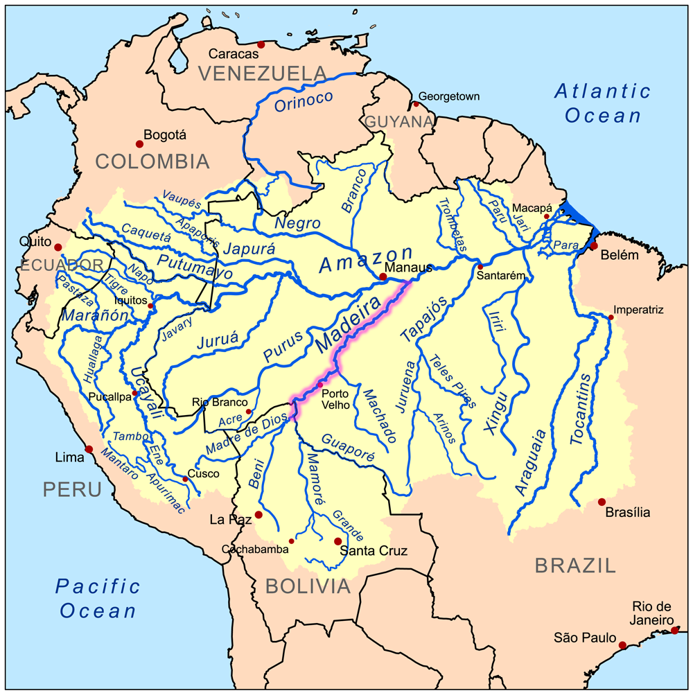
| map_caption | Map of the Madeira River watershed |
| pushpin_map_size | 270 |
| subdivision_type1 | Country |
| subdivision_name1 | Bolivia, Brazil |
| subdivision_type5 | Cities |
| subdivision_name5 | Nova Olinda do Norte, Borba, Novo Aripuanã, Manicoré, Humaitá, Porto Velho |
| length | 1,450 km |
| discharge1_location | near mouth |
| discharge1_min | 2,346 m3/s |
| discharge1_avg | (Period: 1973–1990)31,200 m3/s |
| discharge1_max | 52,804 m3/s |
| source1 | Confluence of Madre de Dios and Mamoré |
| source1_location | Near Guayaramerín, Bolivia |
| source1_coordinates | |
| source1_elevation | 180 m |
| mouth | Amazon River |
| mouth_location | Amazonas, Brazil |
| mouth_coordinates | |
| mouth_elevation | 40 m |
| progression | Amazon → Atlantic Ocean |
| river_system | Amazon |
| basin_size | 1,376,000 km2 |
| tributaries_left | Madre de Dios, Abunã |
| tributaries_right | Mamoré, Jamari, Ji-Paraná, Marmelos, Manicoré, Mataurá, Mariepauá, Aripuanã |
The Madeira River ( ) is a major waterway in South America. It is estimated to be 1,450 km in length, while the Madeira-Mamoré is estimated near 3,250 km or 3,380 km in length depending on the measuring party and their methods. The Madeira is the biggest tributary of the Amazon, accounting for about 15% of the water in the basin. A map from Emanuel Bowen in 1747, held by the David Rumsey Map Collection, refers to the Madeira by the pre-colonial, indigenous name Cuyari. The River of Cuyari, called by the Portuguese Madeira or the Wood River, is formed by two great rivers, which join near its mouth. It was by this River, that the Nation of Topinambes passed into the River Amazon.
Climate
The mean inter-annual precipitations on the great basins vary from 75 to(-), the entire upper Madeira basin receiving 170.5 cm. The greatest extremes of rainfall are between 49 and(-). Even just below the confluence that forms it, the Madeira is one of the largest rivers by discharge of the world, with a mean inter-annual discharge of 18000 m3/s, i.e., 568 km3 per year, approximately half the discharge of the Congo River. On the further course towards the Amazon, the mean discharge of the Madeira increases up to 31200 m3/s.
Course

Between Guajará-Mirim and the falls of Teotônio, the Madeira receives the drainage of the north-eastern slopes of the Andes from Santa Cruz de la Sierra to Cuzco, the whole of the south-western slope of Brazilian Mato Grosso and the northern slope of the Chiquitos sierras. In total, this catchment area, which is slightly more than the combined area of all headwaters, is 850000 km2, almost equal in size to France and Spain combined. The waters flow into the Madeira from many large rivers, the principal of which, (from east to west), are the Guaporé or Iténez, the Baures and Blanco, the Itonamas or San Miguel, the Mamoré, Beni, and Madre de Dios or Mayutata, all of which are reinforced by numerous secondary but powerful affluents. The climate of the upper catchment area varies from humid in the western edge with the origin of the river's main stem by volume (Río Madre de Dios, Río Beni) to semi arid in the southernmost part with the Andine headwaters of the main stem by length (Río Caine, Río Rocha, Río Grande, Mamoré).
All of the upper branches of the river Madeira find their way to the falls across the open, almost level Mojos and Beni plains, 90,000 km2 of which are yearly flooded to an average depth of about 3 ft for a period of from three to four months.

From its source in the confluence of Madre de Dios and Mamoré rivers and downstream to Abuna River the Madeira flows northward forming border between Bolivia and Brazil. Below its confluence with the latter tributary the flow of river changes to north-eastward direction, inland of Rondônia state of Brazil. The section of the river from the border to Porto Velho has notable drop of bed and was not navigable. Before 2012 the falls of Teotônio and of San Antônio existed here, they had higher flow rate and bigger level drop than more famous Boyoma Falls in Africa. Currently these rapids are submerged by the reservoir of Santo Antônio Dam. Below Porto Velho the Madeira meanders north-eastward through the Rondônia and Amazonas states of north west Brazil to its junction with the Amazon.
The 283117 ha Rio Madeira Sustainable Development Reserve, created in 2006, extends along the north bank of the river opposite the town of Novo Aripuanã.{{citation|ref=|language=pt At its mouth is Ilha Tupinambaranas, an extensive marshy region formed by the Madeira's distributaries.
Ecology
As typical of Amazonian rivers with the primary headwaters in the Andes, the Madeira River is turbid because of high sediment levels and it is whitewater, but some of its tributaries are clearwater (e.g., Aripuanã and Ji-Paraná) or blackwater (e.g., Manicoré).
The Bolivian river dolphin, variously considered a subspecies of the Amazon river dolphin or a separate species, is restricted to the upper Madeira River system. It has been estimated that there are more than 900 fish species in the Madeira River Basin, making it one of the freshwater systems in the world with the highest species richness.
In popular culture
The river is the fifth title of the 1993/1999 Philip Glass album Aguas da Amazonia.
Dams
In July 2007, plans have been approved by the Brazilian Government to construct two hydroelectric dams on the Madeira River, the Santo Antônio Dam near Porto Velho and the Jirau Dam about 100 km upstream. Both the Jirau and Santo Antonio dams are run-of-the-river projects that do not impound a large reservoir. Both dams also feature some environmental re-mediation efforts (such as fish ladders). As a consequence, it has been suggested that there has not been strong environmental opposition to the implementation of the Madeira river complex. Yet, if the fish ladders fail, "several valuable migratory fish species could suffer near-extinction as a result of the Madeira dams." There are also concerns with deforestation and pressure on conservation areas and indigenous peoples' territories. The Worldwatch institute has also criticized the fast-track approval process for "kindler, gentler dams with smaller reservoirs, designed to lessen social and environmental impacts", claiming that no project should "fast-track the licensing of new dams in Amazonia and allow projects to circumvent Brazil's tough environmental laws".
Languages
Main article: List of indigenous languages of South America
Indigenous languages of the upper Madeira River basin (in Brazil, Bolivia, and Peru):
Note: † = extinct language
| Classification | Language(s) | Location | No. of speakers |
|---|---|---|---|
| Arawakan | Mojeño (2 dialects): Ignaciano, Trinitario-†Loretano | Mojos de Beni (San Ignácio, Isiboro-Sécure, Trinidad) | 2,000 |
| Arawakan | Terena: Terena, †Chané, dialects influenced by Guaikuru | southern Mato Grosso and southern Santa Cruz | 8,000 (?) |
| Arawakan | Paunaka | near Concepción (Santa Cruz) | 4 |
| Arawakan | Baure (3 dialects): Baure, †Muchojeone, †Paikoneka | savannas in northeastern Beni and forests in northern Santa Cruz | 40 |
| Arawakan | Parecí (3 dialects): Waimaré-Kaxiniti, Kozarini, Enawenê-Nawê | tributaries of the upper Juruena River and the upper Guaporé River (Mato Grosso) | 800 |
| Arawakan | †Sarave(ka) | Santa Cruz (border with Brazil) | 0 |
| Arawakan | Piro: Maniteneri, Iñapari | Pando and Piedras River (Peru) | 300 |
| Arawakan | †Lapaču / Apolista | Yungas de Apolo (La Paz) | 0 |
| Cariban | †Palmela | northeast of Beni, near the Guaporé River | 0 |
| Tupian | Tupi-Guarani (2 dialects): Guarayu, Kagwahib | from the San Pablo River (Ecuador) to the Paragúa River (Santa Cruz); Rondônia and Amazonas | 6,000 |
| Tupian | Sirionó, Yuki | between Trinidad and Santa Cruz | 600 |
| Tupian | Karitiana | east of Porto Velho | 170 |
| Tupian | Puruborá | São Miguel River (Rondônia) | 2 |
| Tupian | Mondé Suruí | Rondônia and Mato Grosso | 700 |
| Tupian | Mondé Gavião-Zoró, Cinta-Larga, Aruá, Salamãi | Rondônia and Mato Grosso | 1,800 |
| Tupian | Arara | Rondônia and Mato Grosso | 150 |
| Tupian | Makurap | east of Rondônia | 50 |
| Tupian | Tupari | Rondônia, coming from Mato Grosso | 150 |
| Tupian | Tsakirabiat, Akuntsu | east of Rondônia | 30 |
| Tupian | Wayoro | east of Rondônia | 10 |
| Tupian | †Kepkiriwat | east of Rondônia | 0 |
| Panoan | 2 dialects: Pakawara / †Karipuna, Chácobo / †Pakaa-Nova | lower Beni River, Yata River and Abunã River | 700 |
| Panoan | †Atsawaka, Yamiaka | Madre de Dios River (Peru) | 0 |
| Panoan | Kaxarari | Abunã River (Rondônia and Amazonas) | 100 |
| Panoan | Yaminawa | Acre and Pando | 500 |
| Tacanan | Araona | Madre de Dios River and Manuripi River | 81 |
| Tacanan | Esse’ Ejja | Madidi River | 500 |
| Tacanan | Cavineña | Beni River and Madidi River | 1,200 |
| Tacanan | Takana | between the upper Beni River and Peru | 1,800 |
| Tacanan | Maropa | upper Beni River | 5 |
| Chapacuran | Wari’ / “Pacaa-Nova” | Pacaás Novos River (Rondônia) | 1,300 |
| Chapacuran | Itene (Moré, Kautário) | Cautário River (Rondônia) and Bolivia | 20 |
| Chapacuran | Oro Win | upper Pacaás Novos River | 5 |
| Chapacuran | Wanyam (Miguelenho) | São Miguel River (Rondônia) | 2 |
| Chapacuran | †Tora, †Urupa | lower Machado River (Rondônia) | 0 |
| Chapacuran | †Chapacura proper, †Nãpeka | Rio Blanco (Santa Cruz) | 0 |
| Nambikwaran | Nambikwara, Northern | between the Cabixi River and Camararé River (Mato Grosso) | 20 |
| Nambikwaran | Nambikwara, Southern | between the upper Guaporé River and Juruena River (Mato Grosso) | 700 |
| Nambikwaran | Sabanê | near Vilhena (Mato Grosso) | 3 |
| Yabuti | Djeoromitxi | Rio Branco (Rondônia) | 40 |
| Yabuti | Arikapu (Mashubi) | Rio Branco (Rondônia) | 2 |
| Macro-Jê | Rikbaktsa (Canoeiro) | Juruena River (Mato Grosso) | 1,000 |
| isolate | Irantxe, Myky | Do Sangue River (Mato Grosso) | 300 |
| isolate | Aikanã (Masaka, Huari) | Corumbiara River and Apediá River (Rondônia) | 170 |
| isolate | Kanoê | Corumbiara River (Rondônia) | 5 |
| isolate | Kwaza (Koaiá) | Apediá River (Rondônia) | 25 |
| isolate | Canichana | San Pedro (Mamoré River) | 1 |
| isolate | Cayuvava | Exaltación (Mamoré River) | 1 |
| isolate | Itonama | northeast of Beni | 4 |
| isolate | Movima | Yacuma River (Beni) | 1,500 |
| isolate | Mosetén, Chimane | near San Borja (Beni) | 6,000 |
| isolate | Yuracare | from the Sécure River to the Ichilo River (Cochabamba) | 3,000 |
| isolate | Chiquitano | central Santa Cruz | 6,000 |
| isolate | Mura-Pirahã | middle Madeira River | 300 |
| isolate | †Matanawi | Castanha River / Roosevelt River | 0 |
| Harakmbet-Katukina | Harakmbet (Amarakaeri, Wachipaeri) | Madre de Dios River (Peru) | 650 |
References
References
- (1979). "The Inland waters of Latin America". [[Food and Agriculture Organization.
- R. Ziesler and G.D. Ardizzone. [https://www.fao.org/3/ad770b/AD770B06.htm LAS AGUAS CONTINENTALES DE AMERICA LATINA/THE INLAND WATERS OF LATIN AMERICA], Fishery Information, Data and Statistics Service. Fisheries Department FAO, Rome.
- [https://www.vle.lt/straipsnis/madeira/ Madeira], ''Visuotinė lietuvių enciklopedija''
- [http://www.talktalk.co.uk/reference/encyclopaedia/hutchinson/m0023864.html "Madeira (river)"]. [http://www.talktalk.co.uk/reference/encyclopaedia/ Talktalk.co.uk] (encyclopedia). Accessed May 2011.
- "Waters". Amazon Waters.
- "Peru, Amazones. - David Rumsey Historical Map Collection".
- Seyler, Patrick. "Hydrological Control on the Temporal Variability of Trace Element Concentration in the Amazon River and its Main Tributaries". Geological Survey of Brazil (CPRM).
- [http://unesco.org.uy/phi/libros/manaos/6.html Water and Salt Balances of the Bolivian Amazon] {{Webarchive. link. (2009-10-10 , UNESCO)
- "Hidrovias Brasileiras". Agencia Nacional de Transportes Aquaviarios (ANTAQ).
- Fraser; Cardoso; Junqueira; Falcão; and Clement (2009). ''Historical ecology and dark earths in whitewater and blackwater landscapes: comparing the Middle Madeira and Lower Negro rivers.'' pp. 229-264 in: Woods; Teixeira; Lehmann; Steiner; WinklerPrins; and Rebellato, eds. ''Amazonian Dark Earths: Wim Sombroek's Vision.'' {{ISBN. 978-1-4020-9031-8
- de Queiroz, L.J.; Torrente-Vilara, G.; Vieira, F.G.; Ohara, W.M.; Zuanon, J.; and Doria, C.R.C. (2013). ''Fishes of Cuniã Lake, Madeira River Basin, Brazil.'' Check List 9(3): 540–548
- Ekström, J. (23 December 2007) ''[http://www.planetcatfish.com/shanesworld/shanesworld.php?article_id=360 Hydroelectric dam constructions in Amazonas.]'' Retrieved 6 February 2013.
- (October 6, 2010). "Brazil Engineers a Critic-Proof Dam". Wall Street Journal.
- (2010). "Greenwashing Hydropower". Worldwatch Institute.
- "Madeira River Basin: Hydropower dams in the heart of the Amazon". World Wildlife Fund Global.
- BBC News Online. 2007. Brazil gives Amazon dams go-ahead. 10 July. Available from: https://news.bbc.co.uk/2/hi/americas/6286804.stm. Accessed 16 July 2007.
- International, Survival. "Write a letter for dam-affected tribes of Brazil".
- Ramirez, Henri. 2006. [http://www.etnolinguistica.org/artigo:ramirez-2006 As línguas indígenas do Alto Madeira: estatuto atual e bibliografia básica]. ''Língua Viva'' vol. 01, n. 01. ([http://www.etnolinguistica.org/local--files/artigo:ramirez-2006/ramirez_2006_madeira.pdf PDF])
This article was imported from Wikipedia and is available under the Creative Commons Attribution-ShareAlike 4.0 License. Content has been adapted to SurfDoc format. Original contributors can be found on the article history page.
Ask Mako anything about Madeira River — get instant answers, deeper analysis, and related topics.
Research with MakoFree with your Surf account
Create a free account to save articles, ask Mako questions, and organize your research.
Sign up freeThis content may have been generated or modified by AI. CloudSurf Software LLC is not responsible for the accuracy, completeness, or reliability of AI-generated content. Always verify important information from primary sources.
Report