From Surf Wiki (app.surf) — the open knowledge base
Lordsburg, New Mexico
| Field | Value |
|---|---|
| name | Lordsburg, New Mexico |
| settlement_type | City |
| image_skyline | Hidalgo County New Mexico Courthouse.jpg |
| image_caption | Hidalgo County Courthouse in Lordsburg |
| image_map | Hidalgo_County_New_Mexico_Incorporated_and_Unincorporated_areas_Lordsburg_Highlighted.svg |
| map_caption | Location of Lordsburg in New Mexico |
| pushpin_map | USA |
| pushpin_map_caption | Location in the United States |
| pushpin_label | Lordsburg |
| subdivision_type | Country |
| subdivision_type1 | State |
| subdivision_type2 | County |
| subdivision_name | United States |
| subdivision_name1 | New Mexico |
| subdivision_name2 | Hidalgo |
| leader_title | Mayor |
| leader_name | Robert Barrera |
| established_title | Founded |
| established_date | 1880 |
| unit_pref | Imperial |
| area_footnotes | |
| area_total_sq_mi | 8.43 |
| area_total_km2 | 21.82 |
| area_land_sq_mi | 8.43 |
| area_land_km2 | 21.82 |
| area_water_sq_mi | 0.00 |
| area_water_km2 | 0.00 |
| population_as_of | [2020](2020-united-states-census) |
| population_total | 2335 |
| population_density_km2 | 107.01 |
| population_density_sq_mi | 277.15 |
| population_footnotes | |
| timezone | MST |
| utc_offset | -7 |
| timezone_DST | MDT |
| utc_offset_DST | -6 |
| coordinates | |
| elevation_footnotes | |
| elevation_ft | 4269 |
| postal_code_type | ZIP codes |
| postal_code | 88009, 88045 |
| area_code | 575 |
| blank_name | FIPS code |
| blank_info | 35-42180 |
| blank1_name | GNIS feature ID |
| blank1_info | 2410872 |
Lordsburg is a city in and the county seat of Hidalgo County, New Mexico, United States. Hidalgo County includes the southern "bootheel" of New Mexico, along the Arizona border. The population was 2,335 at the 2020 census.
History
Lordsburg was founded in 1880 on the route of the Southern Pacific Railroad. The Continental Divide Trail starts at the Crazy Cook Monument and travels through Lordsburg. Local lore is that Billy the Kid washed dishes in Lordsburg hotel kitchens such as the Stratford Hotel, and La Fonda, the historic "inn at the end of the Santa Fe Trail" during his teenage years.
New Mexico state song
Lordsburg is the birthplace of the official New Mexico state song, "O Fair New Mexico".Lordsburg , New Mexico Tourism Department It was written by Lordsburg resident Elizabeth Garrett, the blind daughter of famed sheriff Pat Garrett. In 1917, Governor Washington Ellsworth Lindsey signed the legislation making it the official state song. In 1928, John Philip Sousa presented Governor Arthur T. Hannett and the people of New Mexico an arrangement of the state song embracing a musical story of the Indian, the cavalry, the Spanish and the Mexican.
Lordsburg Municipal Airport
The Lordsburg Municipal Airport (KLSB) began operations in the mid-1920s and was the first airport in New Mexico. Initially the airfield was a cleared parcel of land where pilots could take off and land in any direction. Dirt runways were later constructed. In 1927, Lordsburg was one of the stops on Charles Lindbergh's transcontinental Spirit of Saint Louis air tour. In the early 1950s the airport was served by the original Frontier Airlines (1950–1986), which flew DC-3s on a route from El Paso to Phoenix that included stops at Las Cruces, Deming, and Lordsburg, as well as Clifton, Safford, and Tucson, Arizona. In the mid-1970s one runway had to be relocated to permit the construction of Interstate 10 around Lordsburg and a new paved runway was then constructed. The airport is owned by the City of Lordsburg and is southeast, about one mile outside the city limits.
World War II
Main article: Lordsburg Killings
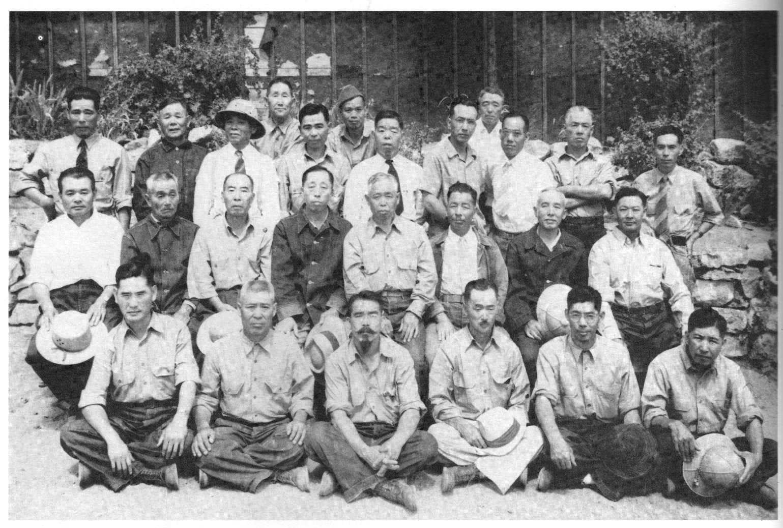
Lordsburg held as many as 1,500 Japanese Americans in a Japanese American internment camp operated by the U.S. Army during World War II. On July 27, 1942, shortly after the Lordsburg Internment Camp was opened, Private First Class Clarence Burleson, a sentry at the facility, allegedly shot two Japanese American internees under questionable circumstances. One of the victims, Hirota Isomura, apparently died instantly. The other, Toshiro Kobata, died before dawn. After a military investigation and court-martial, Burleson was found to have lawfully killed the two men. The camp operated until July 1943. The incident inspired an episode of the new Hawaii 5-0 series, "Ho'oani Makuakane", Episode 4/9 (original air date December 13, 2013).
The camp at Lordsburg also held captured German and Italian soldiers.
Rest stop
For many years, Lordsburg has been a popular rest stop for people traveling to and from the West Coast by car on Interstate 10 and its precursor highway, U.S. Route 80. At 641 mi from downtown Los Angeles, Lordsburg can comfortably be reached by car in less than one day. As Lordsburg had one of the few motels in the Southwest that would accept black guests (El Paso being a notable exception), it was especially popular with black travelers in the mid-20th century during the end of legal segregation.
There are 12 motels and hotels in Lordsburg. Over 300 rooms are available to guests.
Geography
Lordsburg is in northern Hidalgo County, at the intersection of Interstate 10 and U.S. Route 70. I-10 leads east 60 mi to Deming and 120 mi to Las Cruces, while to the west it leads 155 mi to Tucson, Arizona. US 70 follows I-10 to the east out of Lordsburg but leads northwest 153 mi to its terminus at Globe, Arizona.
According to the United States Census Bureau, Lordsburg has a total area of 21.7 km2, all land.
Climate
Lordsburg has a semi-arid climate (Köppen BSk), just avoiding designation as a desert climate (BWk).
Typical for the more southerly and lower elevations of the Intermountain West, summers are extremely hot during the daytime, with maxima above 90 F for over four months on an average of 122 afternoons during a full year. 100 F is exceeded on average during 30 afternoons each year, and the record high of 114 F was set during a notorious southwestern heatwave on June 27, 1994. Humidity in early summer is very low, but increases in late summer due to the monsoon, which, between July and early October brings the majority of the year's limited precipitation. From October temperatures cool off rapidly, and by November most mornings are below 32 F, but afternoons remains comfortable to warm all through the winter, with only 10.1 afternoons failing to reach 50 F and only one afternoon every two years not topping freezing. Minima fall below freezing on an average of 108 mornings, but 0 F has been reached only during two exceptional cold waves in January 1962 and December 1978, when the record low of −14 F was reached on the 9th.
Except for the freakishly wet December 1991 when 4.55 in fell from a series of subtropical cyclones, monthly rainfalls above 4.00 in are restricted to the monsoon season: the wettest month between 1971 and 2000 was July 1981 with 5.34 in. The wettest day has been June 28 of 1981 with 3.00 in. Snowfall is very rare; the median for the year is zero and the mean only 3.5 in; with the heaviest snowfall between 1971 and 2000 being of 11.0 in during Christmas and Boxing Days, 1987. |Jan record high F = 80 |Feb record high F = 85 |Mar record high F = 93 |Apr record high F = 100 |May record high F = 106 |Jun record high F = 114 |Jul record high F = 110 |Aug record high F = 109 |Sep record high F = 104 |Oct record high F = 98 |Nov record high F = 86 |Dec record high F = 76 |year record high F = 114 |Jan record low F = −9 |Feb record low F = 3 |Mar record low F = 11 |Apr record low F = 12 |May record low F = 24 |Jun record low F = 35 |Jul record low F = 49 |Aug record low F = 42 |Sep record low F = 36 |Oct record low F = 19 |Nov record low F = 8 |Dec record low F = −14 |year record low F = −14
Demographics
As of the census of 2000, there were 3,379 people (2,398 est. 2019), 1,220 households, and 854 families residing in the city. The population density was 403.1 PD/sqmi. There were 1,414 housing units at an average density of 168.7 /sqmi. The racial makeup of the city was 80.70% White, 0.56% African American, 0.77% Native American, 0.50% Asian, 13.97% from other races, and 3.49% from two or more races. Hispanic or Latino of any race were 74.43% of the population.
There were 1,220 households, out of which 36.9% had children under the age of 18 living with them, 46.5% were married couples living together, 18.6% had a female householder with no husband present, and 30.0% were non-families. 27.3% of all households were made up of individuals, and 12.4% had someone living alone who was 65 years of age or older. The average household size was 2.70 and the average family size was 3.31.
In the city, the population was spread out, with 31.9% under the age of 18, 8.5% from 18 to 24, 25.6% from 25 to 44, 18.9% from 45 to 64, and 15.0% who were 65 years of age or older. The median age was 33 years. For every 100 females, there were 94.8 males. For every 100 females age 18 and over, there were 89.4 males.
The median income for a household in the city was $21,036, and the median income for a family was $28,026. Males had a median income of $25,952 versus $18,177 for females. The per capita income for the city was $10,877. About 28.6% of families and 32.7% of the population were below the poverty line, including 47.5% of those under age 18 and 19.3% of those age 65 or over.
Cultural reference
Lordsburg is the final destination in Stagecoach, the 9th-greatest Western film of all time according to the American Film Institute, starring John Wayne in his breakthrough role as the Ringo Kid, and directed by John Ford. In 1995, this film was deemed "culturally, historically, or aesthetically significant" by the United States Library of Congress and selected for preservation in their National Film Registry.
In the novel The Last Picture Show, Charlene recounts a run-in with a group of Mexicans in Lordsburg on her way back from Los Angeles.
Education
Lordsburg High School's mascot is the Maverick. Its school colors are orange and black. Students compete in football, volleyball, boys' basketball, girls' basketball, cheer, and boys' and girls' track and field, baseball and softball.
Media
Lordsburg once had two radio stations. During the 1960s KLHS broadcast on 950 kHz AM with 1,000 watts days. This station later moved to Bayard, 55 mi northeast of Lordsburg. The FCC later assigned 97.7 to KXKK in the 1980s, now KPSA-FM; this station has since moved to 98.5.
Transportation
Bus
Greyhound Lines maintains a terminal in Lordsburg.
Airports
- Lordsburg Municipal Airport, private, charter and military (first airport in New Mexico)
- Tucson International Airport, 150 mi west of Lordsburg, is the nearest public airport with scheduled passenger flights.
- El Paso International Airport, 170 mi east of Lordsburg Grant County Airport,(49 miles) northeast of Lordsburg.
Major highways
Rail
- Amtrak's Sunset Limited /Texas Eagle combined train route stops at Lordsburg station three times a week in each direction. Eastbound trains depart at 11:43am on Mondays, Thursdays, and Saturdays, while Westbound trains depart at 4:53pm on Sundays, Tuesdays, and Thursdays.
- The Union Pacific Railroad's mainline and the Arizona Eastern Railway with its branch to Clifton, Arizona, serve Lordsburg.
References
References
- "ArcGIS REST Services Directory". United States Census Bureau.
- {{GNIS. 2410872
- "Find a County". National Association of Counties.
- "Lordsburg-Hidalgo Chamber of Commerce".
- KELLER, TEDDY. (November 26, 1989). "ON THE TRAIL OF BILLY THE KID".
- "New Mexico State Song".
- http://www.airnav.com/airport/KLSB AirNav website
- "Lordsburg :: New Mexico Tourism Department".
- Frontier Airlines timetable: November 1, 1950
- 1978 New Mexico Aeronautical Chart
- "Lordsburg Municipal Airport :: New Mexico Tourism Department".
- "Department of Justice and U.S. Army Facilities".
- "Lordsburg Revisited: A Closer Look at the Lordsburg Court-martial".
- "New Mexico's Prisoner of War Camps".
- Lee, Kurtis. (2020-09-23). "The museum closed first. As in many states, New Mexico's small towns bear the brunt of the pandemic". Los Angeles Times.
- "Geographic Identifiers: 2010 Census Summary File 1 (G001): Lordsburg city, New Mexico". U.S. Census Bureau.
- "Climate Lordsburg - New Mexico and Weather averages Lordsburg". Climate Lordsburg - New Mexico using data from the National Oceanic and Atmospheric Administration (NOAA).
- "Lordsburg 4 SE, New Mexico, USA - Monthly weather forecast and Climate data". NOAA.
- "Census of Population and Housing". Census.gov.
- "Census Population API". United States Census Bureau.
- "U.S. Census website". [[United States Census Bureau]].
- (May 24, 2020). "Population and Housing Unit Estimates". United States Census Bureau.
- [https://www.imdb.com/title/tt0031971/?ref_=fn_al_tt_1 "Stagecoach,"] in the [[Internet Movie Database]], retrieved January 28, 2022
This article was imported from Wikipedia and is available under the Creative Commons Attribution-ShareAlike 4.0 License. Content has been adapted to SurfDoc format. Original contributors can be found on the article history page.
Ask Mako anything about Lordsburg, New Mexico — get instant answers, deeper analysis, and related topics.
Research with MakoFree with your Surf account
Create a free account to save articles, ask Mako questions, and organize your research.
Sign up freeThis content may have been generated or modified by AI. CloudSurf Software LLC is not responsible for the accuracy, completeness, or reliability of AI-generated content. Always verify important information from primary sources.
Report