From Surf Wiki (app.surf) — the open knowledge base
Ligurian Sea
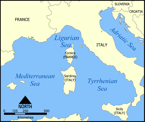
Arm of the Mediterranean Sea north of Corsica
Arm of the Mediterranean Sea north of Corsica

The Ligurian Sea is an arm of the Mediterranean Sea. It lies between the Italian Riviera (Liguria) and the island of Corsica. The sea is thought to have been named after the ancient Ligures people.
Geography
The sea borders Italy as far as its border with France, and the French island of Corsica. In the east, the sea borders the Tyrrhenian Sea, while in the west it borders the Mediterranean Sea proper. Genoa is the most prominent city in the area. The northwest coast is noted for its scenery and climate.
The Gulf of Genoa is its northernmost part. The ports of Genoa and La Spezia are on its rocky coast. It reaches a maximum depth of more than 9,300 ft northwest of Corsica.
According to a 1983 study, since 1977 a series of experimental analyses on sea-level variations at Genoa and Imperia highlighted "the existence of a seiche wave with a mean period of 5.8 hours", whose reasons weren't yet explained at that time. The Ligurian Sea was modeled as a rectangular semi-closed basin with a longitudinal length of 40 km and a transversal one of 10 km, in an average constant depth of 2000 m.{{cite journal | first= Lorenzo |last=Papa | title = A numerical computation of a seiche oscillation of the Ligurian Sea | journal = Geophysical Journal International | volume = 75 | issue = 3 | date = 1 December 1983 | pages = 659–667 | doi = 10.1111/j.1365-246X.1983.tb05004.x | issn = 0956-540X | publisher = Oxford University Press | bibcode = 1983GeoJ...75..659P | oclc = 4640460944 | doi-access = free }}
Extent
The International Hydrographic Organization defines the limits of the Ligurian Sea as follows:
*On the Southwest.* A line joining Cape Corse (Cape Grosso, 9°23′E) the Northern point of Corsica to the frontier between France and Italy (7°31′E). *On the Southeast.* A line joining Cape Corse with Tinetto Island () and thence through Tino and Palmaria Islands to San Pietro Point () on the Coast of Italy. *On the North* The Ligurian Coast of Italy.
Flowings
The Ligurian Sea is traversed by the Modified Atlantic Water (MAW) on its surface and by the Levantine Intermediate Water in depth. It is also brushed by the two main currents which surround the Corsica island: the Western Corsica Current and the Tyrrenian current that reaches the Corsica Channel.
Conservation
In order to provide protection for the numerous cetacean (whales and dolphins; porpoises are not found in this part of the Mediterranean Sea) species in the Ligurian Sea the bordering countries established the sea as a SPAMI in 1999. The International Ligurian Sea Cetacean Sanctuary now covers 84000 km2 covering territorial waters as well as high sea.
Image gallery
File:Corse-04628-Macinaggio-baie.jpg|Rogliano File:Pietracorbara Marine.jpg|Pietracorbara File:Trota Caput.JPG|Portovenere File:Drop the Gulf.JPG|Palmaria File:Panorama di La Spezia 08.jpg|La Spezia File:Vernazza view 2.jpg|Vernazza File:Corniglia FB02.JPG|Corniglia File:Monterosso al Mare-panorama-convento dei cappuccini2-flickr.jpg|Monterosso al Mare File:Liguria 5Terre3 tango7174.jpg|Riomaggiore File:Italy.Cinque.Terre.Manarola.2.jpg|Manarola File:Sori-panorama8.JPG|Sori File:Porto Genova 0038.JPG|Genoa File:Fortezza del Priamar dalle alture Savonesi.JPG|Savona File:Ceriale DSCF4261.JPG|Ceriale File:Alassio from Capo Mele.jpg|Alassio File:Laigueglia05.jpg|Laigueglia File:Imperia Porto Maurizio BMK.jpg|Imperia File:San Remo Harbour in May 2008.JPG|Sanremo File:La piana di latte.jpg|Ventimiglia
References
Notes
Citations
References
- (1953). "Limits of Oceans and Seas, 3rd edition". International Hydrographic Organization.
- (2003). "Comparison between XBT data and TOPEX/Poseidon satellite altimetry in the Ligurian-Tyrrhenian area". European Geosciences Union.
This article was imported from Wikipedia and is available under the Creative Commons Attribution-ShareAlike 4.0 License. Content has been adapted to SurfDoc format. Original contributors can be found on the article history page.
Ask Mako anything about Ligurian Sea — get instant answers, deeper analysis, and related topics.
Research with MakoFree with your Surf account
Create a free account to save articles, ask Mako questions, and organize your research.
Sign up freeThis content may have been generated or modified by AI. CloudSurf Software LLC is not responsible for the accuracy, completeness, or reliability of AI-generated content. Always verify important information from primary sources.
Report