From Surf Wiki (app.surf) — the open knowledge base
Liberty, Missouri
City in and county seat of Clay County, Missouri, United States
City in and county seat of Clay County, Missouri, United States
| Field | Value |
|---|---|
| name | Liberty, Missouri |
| settlement_type | City |
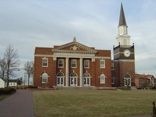
| image_skyline | File:Liberty Courthouse.jpg |
| image_caption | Historic Clay County Courthouse in Liberty, Missouri |
| image_map | Clay_County_Missouri_Incorporated_and_Unincorporated_areas_Liberty_Highlighted.svg |
| mapsize | 250x200px |
| map_caption | Location in the state of Missouri and in Clay County |
| subdivision_type | Country |
| subdivision_type1 | State |
| subdivision_type2 | County |
| subdivision_name | United States |
| subdivision_name1 | Missouri |
| subdivision_name2 | Clay |
| established_title | Incorporated |
| established_date | May 7, 1829 (as a town), 1851 (as a city) |
| government_type | Mayor-Council-Administrator |
| leader_title | Mayor |
| leader_name | Greg Canuteson |
| area_total_sq_mi | 29.16 |
| area_land_sq_mi | 29.03 |
| area_water_sq_mi | 0.13 |
| area_footnotes | |
| area_total_km2 | 75.52 |
| area_land_km2 | 75.19 |
| area_water_km2 | 0.33 |
| elevation_footnotes | |
| elevation_ft | 863 |
| coordinates | |
| population_as_of | [2020](2020-united-states-census) |
| population_total | 30167 |
| population_density_sq_mi | 1039.09 |
| population_density_km2 | 401.19 |
| timezone | CST |
| utc_offset | −6 |
| timezone_DST | CDT |
| utc_offset_DST | −5 |
| postal_code_type | ZIP codes |
| postal_code | 64068, 64069 |
| area_codes | 816, 975 |
| blank_name | FIPS code |
| blank_info | |
| blank1_name | GNIS feature ID |
| blank1_info | 2395700 |
| website | |
| unit_pref | Imperial |
|
Liberty is a city in and the county seat of Clay County, Missouri, United States and is a suburb of Kansas City, located in the Kansas City Metro Area. As of the 2020 United States census the population was 30,167. Liberty is home to William Jewell College and the historic Liberty Jail.
History

Liberty was settled in 1822, and shortly later became the county seat of Clay County. The city was named for the American concept of liberty.
In 1830, David Rice Atchison established a law office in Liberty. He was joined three years later by colleague Alexander William Doniphan. The two argued cases defending the rights of Mormon settlers in Jackson County, served Northwest Missouri in Missouri's General Assembly, and labored for the addition of the Platte Purchase to Missouri's boundaries.
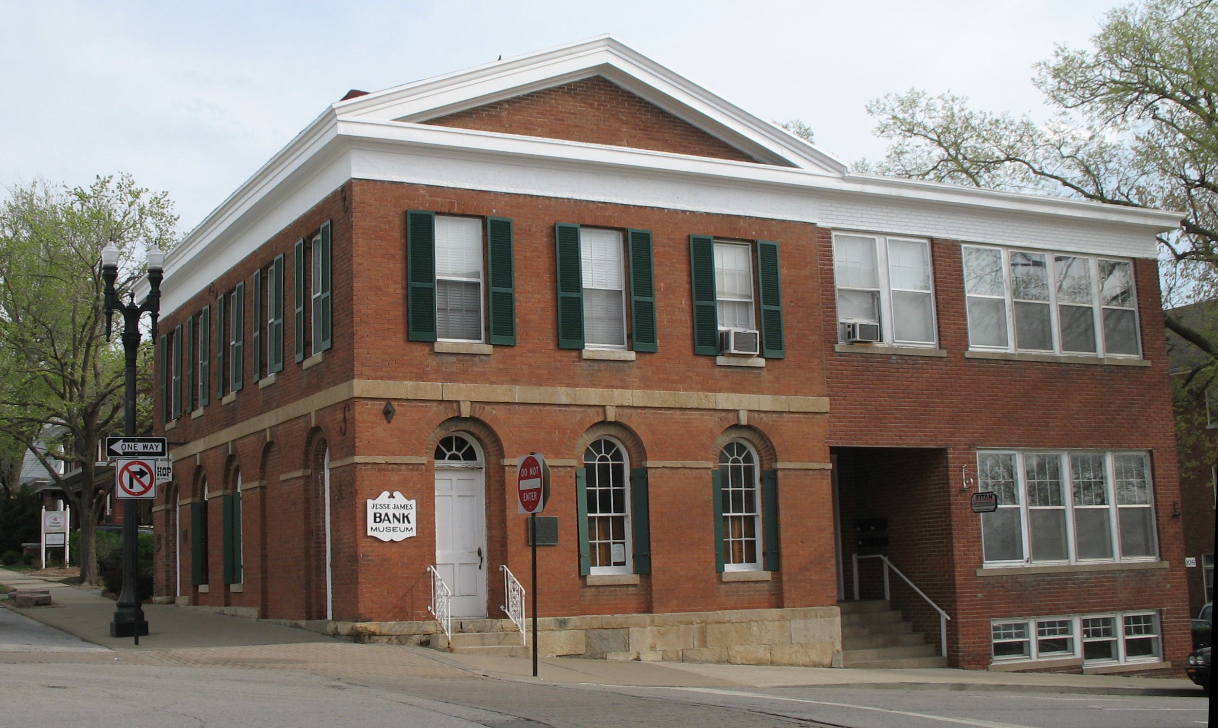
In October 1838, the two were ordered by Governor Lilburn Boggs to arrest Mormon founder Joseph Smith Jr. at the Far West settlement in Caldwell County. Immediately after the conclusion of the Mormon War, Smith and other Mormon leaders were incarcerated at the Liberty Jail for the winter as Doniphan labored for a quicker trial date. Although Doniphan led a force of Missouri volunteers ordered to capture the leaders, he defended Joseph Smith in trial and won him a change in venue. While en route to their new venue, Smith and his followers escaped and left Missouri for the new Mormon settlement in Nauvoo, Illinois.
The Arthur-Leonard Historic District, Clay County Savings Association Building, Clinton House, Dougherty-Prospect Heights Historic District, Garrison School Historic District, Frank Hughes Memorial Library, IOOF Liberty Lodge No. 49, Jewell Hall, Jewell-Lightburne Historic District, Major Hotel, Miller Building, Mt. Memorial Cemetery, Nebo Hill Archeological Site, Odd Fellows Home District, South Liberty Courthouse Square Historic District, and West Liberty Courthouse Square Historic District are listed on the National Register of Historic Places.
Geography
Liberty is located approximately six miles north of the Missouri River along I-35 and Missouri Route 291.
According to the United States Census Bureau, the city has a total area of 29.15 sqmi, of which 29.03 sqmi is land and 0.12 sqmi is water.
Demographics
2020 census
The 2020 United States census counted 30,167 people, 10,816 households, and 7,602 families in Liberty. The population density was 1,039.2 per square mile (401.2/km). There were 11,505 housing units at an average density of 396.3 per square mile (153.0/km). The racial makeup was 84.17% (25,391) white, 4.57% (1,378) black or African-American, 0.46% (139) Native American, 1.0% (303) Asian, 0.15% (46) Pacific Islander, 1.58% (478) from other races, and 8.06% (2,432) from two or more races. Hispanic or Latino of any race was 6.1% (1,932) of the population.
Of the 10,816 households, 32.8% had children under the age of 18; 53.4% were married couples living together; 26.5% had a female householder with no husband present. Of all households, 23.6% consisted of individuals and 8.5% had someone living alone who was 65 years of age or older. The average household size was 2.8 and the average family size was 3.3.
27.7% of the population was under the age of 18, 9.2% from 18 to 24, 29.3% from 25 to 44, 25.7% from 45 to 64, and 13.3% who were 65 years of age or older. The median age was 35.8 years. For every 100 females, the population had 99.4 males. For every 100 females ages 18 and older, there were 92.7 males.
The 2016-2020 5-year American Community Survey estimates show that the median household income was $78,184 (with a margin of error of +/- $5,139) and the median family income was $90,839 (+/- $5,167). Males had a median income of $48,640 (+/- $3,513) versus $32,463 (+/- $1,897) for females. The median income for those above 16 years old was $40,538 (+/- $2,938). Approximately, 3.3% of families and 7.0% of the population were below the poverty line, including 8.0% of those under the age of 18 and 4.8% of those ages 65 or over.
2010 census
As of the census of 2010, there were 29,149 people, 10,582 households, and 7,555 families living in the city. The population density was 1004.1 PD/sqmi. There were 11,284 housing units at an average density of 388.7 /sqmi. The racial makeup of the city was 91.4% White, 3.6% African American, 0.5% Native American, 1.0% Asian, 0.1% Pacific Islander, 0.9% from other races, and 2.6% from two or more races. Hispanic or Latino of any race were 4.1% of the population.
There were 10,582 households, of which 38.2% had children under the age of 18 living with them, 56.4% were married couples living together, 11.0% had a female householder with no husband present, 4.0% had a male householder with no wife present, and 28.6% were non-families. 23.4% of all households were made up of individuals, and 8% had someone living alone who was 65 years of age or older. The average household size was 2.63 and the average family size was 3.11.
The median age in the city was 36.4 years. 26.6% of residents were under the age of 18; 9.8% were between the ages of 18 and 24; 26% were from 25 to 44; 26.5% were from 45 to 64; and 11.1% were 65 years of age or older. The gender makeup of the city was 48.7% male and 51.3% female.
2000 census
As of the census of 2000, there were 26,232 people, 9,511 households, and 6,943 families living in the city. The population density was 973.3 PD/sqmi. There were 9,973 housing units at an average density of 370.0 /sqmi. The racial makeup of the city was 93.75% White, 2.59% African American, 0.40% Native American, 0.61% Asian, 0.06% Pacific Islander, 0.99% from other races, and 1.59% from two or more races. Hispanic or Latino of any race were 2.68% of the population.
There were 9,511 households, out of which 38.9% had children under the age of 18 living with them, 59.2% were married couples living together, 10.9% had a female householder with no husband present, and 27.0% were non-families. 22.4% of all households were made up of individuals, and 7.9% had someone living alone who was 65 years of age or older. The average household size was 2.62 and the average family size was 3.08.
In the city the population was spread out, with 27.6% under the age of 18, 10.4% from 18 to 24, 30.2% from 25 to 44, 21.5% from 45 to 64, and 10.4% who were 65 years of age or older. The median age was 34 years. For every 100 females, there were 91.9 males. For every 100 females age 18 and over, there were 89.6 males.
The median income for a household in the city was $52,745, and the median income for a family was $61,273. Males had a median income of $41,713 versus $28,516 for females. The per capita income for the city was $23,415. About 3.8% of families and 5.0% of the population were below the poverty line, including 5.1% of those under age 18 and 6.1% of those age 65 or over.
Economy
Major employers in Liberty include the Hallmark distribution warehouse. Liberty is also home to the operations headquarters for Ferrellgas, the 2nd largest retail provider of propane in the United States. The B&B Theatres corporate office is located in Liberty, the 5th largest theater chain in the U.S. While technically not in Liberty, the Ford Kansas City Assembly Plant is a major employer in nearby Claycomo.
Top employers
According to the town's 2016 Comprehensive Annual Financial Report, the top employers in the city are:
| # | Employer | # of Employees | |
|---|---|---|---|
| 1 | Liberty Public Schools | 2,109 | |
| 2 | Liberty Hospital | 1,400 | |
| 3 | Hallmark Cards | 820 | |
| 4 | RR Donnelley | 350 | |
| 5 | Clay County | 350 | |
| 6 | City of Liberty | 325 | |
| 7 | Ferrellgas | 263 | |
| 8 | Ford Stamping Plant | 256 | |
| 9 | William Jewell | 235 | |
| 10 | LMV | 185 |
Education
The Liberty 53 School District, which covers almost all of the municipality, operates ten elementary, four middle and two senior high schools.
Metropolitan Community College has the Liberty school district in its taxation area.
Liberty has a public library, a branch of the Mid-Continent Public Library.
Liberty is also home to William Jewell College, a private, four-year liberal arts college of more than 900 undergraduate students that was founded in 1849.
Notable people
- David Allen, former American football running back for the Jacksonville Jaguars and St. Louis Rams
- David Rice Atchison - United States Senator (D) President Pro-tem March 4-5, 1849
- Ken Boyer, former third baseman and manager of the St. Louis Cardinals
- Greg Canuteson, former mayor and state representative
- James Dewees, keyboardist and back-up vocalist of The Get Up Kids, and started Reggie and the Full Effect
- Alexander William Doniphan, Mexican War general Missouri State Rep. 1836, 1840, 1854.
- John Dougherty - United States House of Represenatives 1899-1905
- Hubert Eaton, visionary and developer of the world-famous Forest Lawn cemeteries in California
- Shea Groom, professional soccer player
- Gatewood Lincoln, 1898 Graduate of West Point Military Academy, served in the Spanish American War and in both World Wars and twice governor of American Samoa
- Hunter Mense, Coach for the Toronto Blue Jays
- George Rice, football player for the Houston Oilers and Chicago Bears
- Johnny Ringo - Outlaw, lived in Liberty 1856-1858.
- Nick Robinson, former Stanford University basketball player and 2024 coach at the University of Kentucky.
- Alex Saxon, actor (The Fosters, Finding Carter)
- Bill Snyder - former University of Kansas football coach. William Jewell College graduate.
- Eric Staves, actor Goat (2016 film), Empire (2015 TV series) and American Horror Story: 1984
- Craig Stevens, star of the 1950s television series Peter Gunn
- Bennett Stirtz, college basketball player (Northwest Missouri State, Drake, Iowa)
- Matt Wertz, soft rock singer/songwriter
Cultural references
The Liberty Jail is now an open museum and tourist site. The Clay County Historical Society Museum features period room displays, a historic pharmacy counter, toys and dolls, model trains, tools and more.
Twin towns
- LUX Diekirch, Luxembourg
References
References
- "History of Liberty | the City of Liberty Official Website!".
- "City of Liberty, Missouri: Comprehensive Annual Financial Report For The Year Ended December 31, 2011".
- "ArcGIS REST Services Directory". United States Census Bureau.
- "U.S. Census website". [[United States Census Bureau]].
- {{Cite GNIS. 2395700. Liberty
- "Find a County". National Association of Counties.
- Eaton, David Wolfe. (1916). "How Missouri Counties, Towns and Streams Were Named". The State Historical Society of Missouri.
- "Clay County Place Names, 1928–1945". The State Historical Society of Missouri.
- Muench, James F.. (2006). "Five Stars: Missouri's Most Famous Generals". University of Missouri Press.
- {{NRISref
- (2012-05-04). "National Register of Historic Places Listings". National Park Service.
- ''Missouri Atlas & Gazetteer,'' DeLorme, 1998, First edition, p. 27, {{ISBN. 0-89933-224-2
- "US Gazetteer files 2010". [[United States Census Bureau]].
- "Census of Population and Housing". Census.gov.
- "QuickFacts: Liberty city, Missouri".
- "Explore Census Data".
- "Explore Census Data".
- "U.S. Census website". [[United States Census Bureau]].
- "City of Liberty 2015 Comprehensive Annual Financial Report".
- Geography Division. (January 12, 2021). "2020 CENSUS - SCHOOL DISTRICT REFERENCE MAP: Clay County, MO". [[U.S. Census Bureau]].
- "MCC SERVICE AREAS". [[Metropolitan Community College (Missouri).
- "Locations". Mid-Continent Public Library.
- (2018-02-08). "About". William Jewell College.
- Houx, Kellie. (Aug 31, 2017). "Former mayor receives Civic Leadership Award". Courier-Tribune.
- Lara, Cindy. (2017-09-06). "Shea Groom named Player of the Week". VAVEL.com.
This article was imported from Wikipedia and is available under the Creative Commons Attribution-ShareAlike 4.0 License. Content has been adapted to SurfDoc format. Original contributors can be found on the article history page.
Ask Mako anything about Liberty, Missouri — get instant answers, deeper analysis, and related topics.
Research with MakoFree with your Surf account
Create a free account to save articles, ask Mako questions, and organize your research.
Sign up freeThis content may have been generated or modified by AI. CloudSurf Software LLC is not responsible for the accuracy, completeness, or reliability of AI-generated content. Always verify important information from primary sources.
Report