From Surf Wiki (app.surf) — the open knowledge base
Lane County, Oregon
County in Oregon, United States

County in Oregon, United States
| Field | Value |
|---|---|
| county | Lane County |
| state | Oregon |
| founded date | January 29 |
| founded year | 1851 |
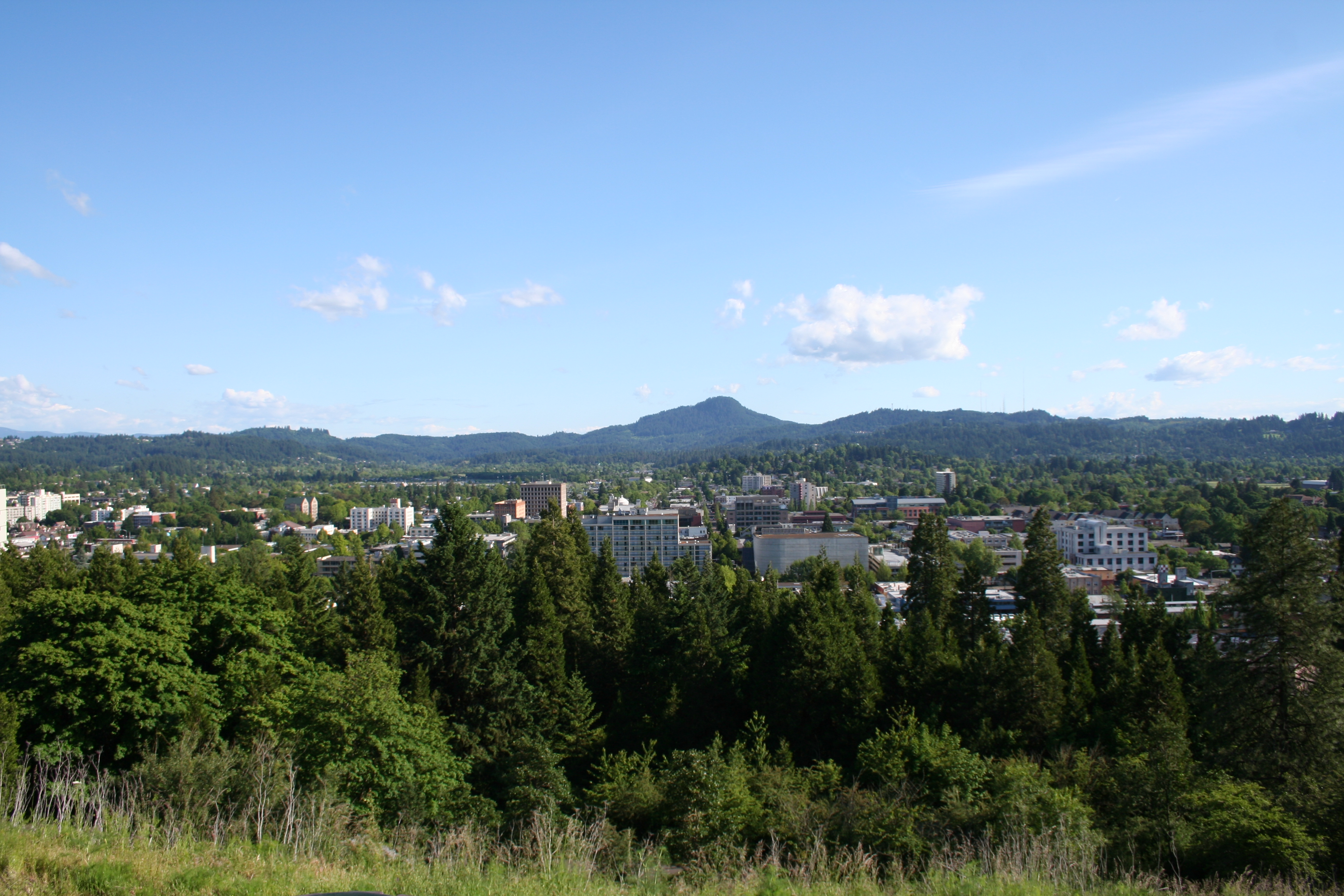
| seat wl | Eugene |
| largest city wl | Eugene |
| area_total_sq_mi | 4722 |
| area_land_sq_mi | 4553 |
| area_water_sq_mi | 169 |
| area percentage | 3.6% |
| population_as_of | 2020 |
| population_total | 382971 |
| pop_est_as_of | 2024 |
| population_est | 382396 |
| density_sq_mi | auto |
| district | 4th |
| web | https://www.lanecounty.org |
| time zone | Pacific |
| ex image | 1898 Lane County Courthouse (Lane County, Oregon scenic images) (lanD0040a).jpg |
| ex image cap | Lane County Courthouse in Eugene, built in 1898 and demolished in 1959 |
| named for | Joseph Lane |
Lane County is one of the 36 counties in the U.S. state of Oregon. As of the 2020 census, the population was 382,971, making it the fourth-most populous county in Oregon. The county seat is Eugene, the state's second most populous city. It is named in honor of Joseph Lane, Oregon's first territorial governor. Lane County comprises the Eugene, OR Metropolitan Statistical Area. It is the third-largest MSA in Oregon, and the 144th-largest in the country.
History
Lane County was established on January 29, 1851. It was created from the southern part of Linn County and the portion of Benton County east of Umpqua County. It was named after the territory's first governor, Joseph Lane. Originally it covered all of southern Oregon east to the Cascade Mountains and south to the California border. When the Territorial Legislature created Lane County, it did not designate a county seat. In the 1853 election, four sites competed for the designation, of which the "Mulligan donation" received a majority vote; however, since it was contiguous to the "Skinner claim" both became part of the new county seat known as Eugene.
In 1846, Elijah Bristow and his wife, the former Susannah Gabbart, had become the first white settlers to build a claim cabin within the present-day boundaries of Lane County, near Pleasant Hill. They had crossed the plains to California in the previous year, and came north with Eugene F. Skinner, Captain Felix Scott, and William Dodson. As their party entered the valley between the Coast Fork and Middle Fork of the Willamette River, Bristow gazed around and exclaimed, "What a pleasant hill! Here is my home!"
In 1852, John Diamond and William Macy led an exploration party to survey a shortcut for the Oregon Trail across the Cascade Range. The shortcut over the Willamette Pass became known as the Free Emigrant Road. Around 250 wagons with 1,027 people left the usual Oregon Trail route at Vale, Oregon, and followed Elijah Elliott through the central Oregon high desert. This became known as the Elliott Cutoff. When they reached what is now Bend, they sent scouts to the south to look for the road. Once settlers in the Willamette Valley discovered the emigrants were coming, a huge rescue effort was launched as the emigrants were out of supplies and in dire condition. The emigrants of this wagon train doubled the population of Lane County in 1853.
The county has been vastly reduced from its original size by several boundary changes. One of the first changes gave it access to the Pacific Ocean, when it acquired the northern part of Umpqua County in 1853. With the creation of Wasco County in 1854, it lost all of its territory east of the Cascade Mountains. Minor boundary changes occurred with Douglas County in 1852, 1885, 1903, 1915, and 1917; with Linn County in 1907 and with Benton County in 1923.
Geography

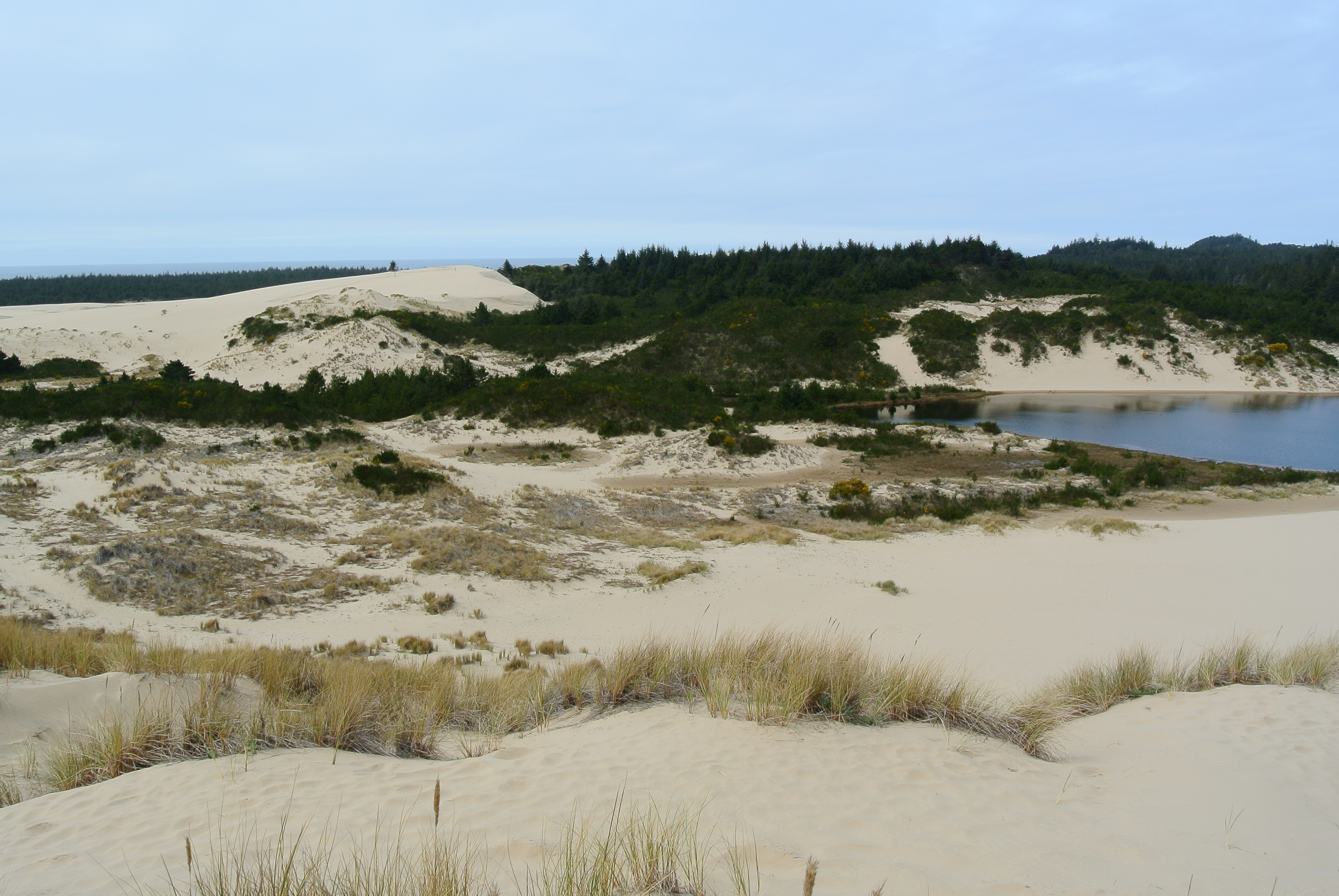
According to the United States Census Bureau, the county has a total area of 4722 sqmi, of which 4553 sqmi is land and 169 sqmi (3.6%) is water. Lane County is one of two Oregon counties that extend from the Pacific Ocean to the Cascades (the other is Douglas County.) A portion of the Umpqua National Forest is in Lane County. Portions of the Willamette, McKenzie, and Siuslaw rivers run through the county.
Adjacent counties
- Lincoln County (northwest)
- Benton County (north)
- Linn County (northeast)
- Deschutes County (east)
- Klamath County (southeast)
- Douglas County (south)
National protected areas
- Oregon Islands National Wildlife Refuge (part)
- Siuslaw National Forest (part)
- Umpqua National Forest (part)
- Willamette National Forest (part)
Demographics
|align-fn=center 1790–1960 1900–1990 1990–2000 2010–2020
2020 census
| Race / Ethnicity (*NH = Non-Hispanic*) | title=1980 Census of Population - General Population Characteristics - Oregon - Table 58 - Persons by Race and Table 59 - Total Persons and Spanish Origin Persons by Type of Spanish Origin and Race (p. 39/24-39/32) | url=https://www2.census.gov/library/publications/decennial/1980/volume-1/oregon/1980a_orabc-05.pdf | website=United States Census Bureau | page=}} | title=1990 Census of Population - General Population Characteristics - Oregon - Table 5 - Race and Hispanic Origin | url=https://www2.census.gov/library/publications/decennial/1990/cp-1/cp-1-39.pdf | website=United States Census Bureau | page=9-30}} | title=P004: Hispanic or Latino, and Not Hispanic or Latino by Race – 2000: DEC Summary File 1 – Lane County, Oregon | url=https://data.census.gov/table?g=050XX00US41039&tid=DECENNIALSF12000.P004 | website=United States Census Bureau | access-date= }} | title=P2: Hispanic or Latino, and Not Hispanic or Latino by Race – 2010: DEC Redistricting Data (PL 94-171) – Lane County, Oregon | url=https://data.census.gov/cedsci/table?q=p2&g=050XX00US41039&tid=DECENNIALPL2010.P2 | website=United States Census Bureau | access-date= }} | Pop 2020 | % 1980 | % 1990 | % 2000 | % 2010 | % 2020 |
|---|---|---|---|---|---|---|---|---|---|---|---|---|---|---|---|---|---|---|---|---|---|---|
| White alone (NH) | 261,505 | 265,391 | 286,075 | 297,808 | 298,507 | 95.01% | 93.81% | 88.58% | 84.67% | 77.95% | ||||||||||||
| Black or African American alone (NH) | 1,566 | 2,040 | 2,391 | 3,102 | 4,352 | 0.57% | 0.72% | 0.74% | 0.88% | 1.14% | ||||||||||||
| Native American or Alaska Native alone (NH) | 2,471 | 3,017 | 3,268 | 3,418 | 3,355 | 0.90% | 1.07% | 1.01% | 0.97% | 0.88% | ||||||||||||
| Asian alone (NH) | 2,919 | 5,419 | 6,390 | 8,169 | 9,404 | 1.06% | 1.92% | 1.98% | 2.32% | 2.46% | ||||||||||||
| Native Hawaiian or Pacific Islander alone (NH) | x | x | 562 | 732 | 947 | x | x | 0.17% | 0.21% | 0.25% | ||||||||||||
| Other race alone (NH) | 1,184 | 193 | 534 | 514 | 2,377 | 0.43% | 0.07% | 0.17% | 0.15% | 0.62% | ||||||||||||
| Mixed race or Multiracial (NH) | x | x | 8,865 | 11,805 | 26,249 | x | x | 2.74% | 3.36% | 6.85% | ||||||||||||
| Hispanic or Latino (any race) | 5,581 | 6,852 | 14,874 | 26,167 | 37,780 | 2.03% | 2.42% | 4.61% | 7.44% | 9.86% | ||||||||||||
| **Total** | **275,226** | **282,912** | **322,959** | **351,715** | **382,971 ** | **100.00%** | **100.00%** | **100.00%** | **100.00%** | **100.00%** |
As of the 2020 census, the county had a population of 382,971. Of the residents, 18.1% were under the age of 18 and 20.9% were 65 years of age or older; the median age was 40.6 years. For every 100 females there were 97.1 males, and for every 100 females age 18 and over there were 95.2 males. 82.0% of residents lived in urban areas and 18.0% lived in rural areas.
As of the 2020 census, the racial makeup of the county was 80.7% White, 1.2% Black or African American, 1.2% American Indian and Alaska Native, 2.5% Asian, 0.3% Native Hawaiian and Pacific Islander, 3.9% from some other race, and 10.1% from two or more races. Hispanic or Latino residents of any race comprised 9.9% of the population.
As of the 2020 census, the non-Hispanic white population accounted for 77.95% of residents, non-Hispanic African Americans 1.14%, non-Hispanic Native Americans 0.88%, non-Hispanic Asians 2.46%, and non-Hispanic individuals reporting two or more races 6.85%.
As of the 2020 census, there were 156,594 households in the county, of which 24.3% had children under the age of 18 living with them and 28.0% had a female householder with no spouse or partner present; 29.4% of all households were made up of individuals and 13.4% had someone living alone who was 65 years of age or older.
As of the 2020 census, there were 166,226 housing units, of which 5.8% were vacant. Among occupied housing units, 59.2% were owner-occupied and 40.8% were renter-occupied; the homeowner vacancy rate was 1.0% and the rental vacancy rate was 4.4%.
2010 census
As of the 2010 census, there were 351,715 people, 145,966 households, and 86,938 families living in the county. The population density was 77.2 PD/sqmi. There were 156,112 housing units at an average density of 34.3 /mi2. The racial makeup of the county was 88.3% white, 2.4% Asian, 1.2% American Indian, 1.0% black or African American, 0.2% Pacific islander, 2.8% from other races, and 4.2% from two or more races. Those of Hispanic or Latino origin made up 7.4% of the population. In terms of ancestry, 21.8% were German, 14.9% were English, 13.8% were Irish, and 5.3% were American.
Of the 145,966 households, 26.3% had children under the age of 18 living with them, 44.3% were married couples living together, 10.6% had a female householder with no husband present, 40.4% were non-families, and 28.9% of all households were made up of individuals. The average household size was 2.35 and the average family size was 2.87. The median age was 39.0 years.

The median income for a household in the county was $42,923 and the median income for a family was $55,817. Males had a median income of $43,383 versus $32,745 for females. The per capita income for the county was $23,869. About 10.0% of families and 16.7% of the population were below the poverty line, including 17.1% of those under age 18 and 8.7% of those age 65 or over.
Lane County is the fourth-most populous county in Oregon. It grew more slowly from 2000 to 2010 than did the three larger counties, Multnomah (the most populous Oregon county), Washington and Clackamas.
2000 census
As of the census of 2000, there were 322,959 people, 130,453 households, and 82,185 families living in the county. The population density was 71 /mi2. There were 138,946 housing units at an average density of 30 /mi2. The racial makeup of the county was 90.64% White, 0.78% Black or African American, 1.13% Native American, 2.00% Asian, 0.19% Pacific Islander, 1.95% from other races, and 3.32% from two or more races. 4.61% of the population were Hispanic or Latino of any race.
There were 130,453 households, out of which 28.50% had children under the age of 18 living with them, 48.90% were married couples living together, 10.00% had a female householder with no husband present, and 37.00% were non-families. 26.60% of all households were made up of individuals, and 9.10% had someone living alone who was 65 years of age or older. The average household size was 2.42 and the average family size was 2.92.
In the county, the population was spread out, with 22.90% under the age of 18, 12.00% from 18 to 24, 27.50% from 25 to 44, 24.40% from 45 to 64, and 13.30% who were 65 years of age or older. The median age was 37 years. For every 100 females there were 96.90 males. For every 100 females age 18 and over, there were 94.70 males.
The median income for a household in the county was $36,942, and the median income for a family was $45,111. Males had a median income of $34,358 versus $25,103 for females. The per capita income for the county was $19,681. About 9.00% of families and 14.40% of the population were below the poverty line, including 16.10% of those under age 18 and 7.50% of those age 65 or over.
Government
Lane County is governed by a County commission. Commissioners are elected officials and serve four-year terms. The current commissioners are:
- David Lovell, Springfield
- Ryan Ceniga, West Lane
- Heather Buch, East Lane
- Laurie Trieger, South Eugene
- Pat Farr, North Eugene
In presidential elections from the 1950s through the 70s, Lane County mostly leaned towards Republican candidates, but returned to a solidly Democratic county in 1984, coming to often back Democratic candidates in statewide elections by broad margins. It is one of many counties dominated by college towns that swung heavily Democratic in this period.
Through much of the mid-1800s and the first half of the 20th century, the region served as a stronghold for the pro-slavery National Democratic Party. In the 1920s the county was considered the state headquarters for the Ku Klux Klan. Major Luther I. Powell, a resident of the county and Klan leader, led early efforts to establish the Klan, first in Eugene and then across Oregon.
Lane County is currently one of 11 counties in Oregon in which therapeutic psilocybin is legal.
Politics
Economy
As of 2022, Lane County has the fifth-largest gross domestic product among Oregon's 36 counties, totaling $17.55 billion.
Tourism has become a key driver of the local economy, with direct visitor spending reaching $1.1 billion in 2023, and total travel spending hitting a record $1.4 billion.
PeaceHealth Medical Group is the largest private employer in Lane County, followed by the University of Oregon, Eugene 4J School District, and U.S. Government.
Growth in the next decades is predicted to shift away from timber and agriculture to services, manufacturing of transportation equipment, printing and publishing, and high technology.
Communities
Incorporated cities
- Coburg
- Cottage Grove
- Creswell
- Dunes City
- Eugene (county seat)
- Florence
- Junction City
- Lowell
- Oakridge
- Springfield
- Veneta
- Westfir
Census-designated places
- Cheshire
- Dexter
- Elmira
- Heceta Beach
- Jasper
- Mapleton
- Marcola
- River Road
- Santa Clara
- Trent
Other unincorporated communities
- Ada
- Alpha
- Alvadore
- Austa
- Belknap Springs
- Blachly
- Blue River
- Camp Creek
- Canary
- Cedar Flat
- Cheshire
- Cloverdale
- Crow
- Culp Creek
- Cushman
- Deadwood
- Deerhorn
- Dexter
- Disston
- Dorena
- Elmira
- Finn Rock
- Glenada
- Glenwood
- Goldson
- Goshen
- Greenleaf
- Heceta
- Horton
- Indiola
- Inlow
- Jasper
- Lancaster
- Latham
- Leaburg
- Linslaw
- London Springs
- Lorane
- Low Pass
- Mabel
- Malabon
- Mapleton
- Marcola
- McKenzie Bridge
- Minerva
- Mohawk
- Nimrod
- North Beach
- Noti
- Pleasant Hill
- Rainbow
- Riverview
- Saginaw
- Santa Clara
- Siltcoos
- Swisshome
- Tide
- Tiernan
- Trent
- Triangle Lake
- Unity
- Vaughn
- Vida
- Walden
- Walker
- Walterville
- Walton
- Wendling
- Westlake
- Wildwood
Former communities
- Alma
- Bethel, now part of Eugene
- Black Butte
- Bohemia City
- Divide
- Irving, now part of Eugene
- Luper
- McCredie Springs
- Natron
- Thurston, now part of Springfield
Education
School districts include:
- Alsea School District 7J
- Bethel School District 52
- Blachly School District 090
- Creswell School District 40
- Crow-Applegate-Lorane School District 66
- Eugene School District 4J
- Fern Ridge School District 28J
- Harrisburg School District 7J
- Junction City School District 69
- Lincoln County School District
- Lowell School District 71
- Mapleton School District 32
- Marcola School District 79J
- McKenzie School District 68
- Monroe School District 1J
- Oakridge School District 76
- Pleasant Hill School District 1
- Siuslaw School District 97J
- South Lane School District 45J
- Springfield School District 19
References
References
- "About Us". Lane County Historical Society.
- "State & County QuickFacts". United States Census Bureau.
- "Find a County". National Association of Counties.
- "Annual Estimates of the Population of Metropolitan and Micropolitan Statistical Areas: April 1, 2000 to July 1, 2008".
- (December 1, 2009). "OMB Bulletin No. 10-02: Update of Statistical Area Definitions and Guidance on Their Uses". [[United States Office of Management and Budget]].
- Gannett, Henry. (1905). "The Origin of Certain Place Names in the United States". [[United States Government Publishing Office.
- Walling, Albert G.. (1884). "Illustrated History of Lane County Oregon". Printing house of A. G. Walling.
- Friedman, Ralph. (1990). "In Search of Western Oregon". Caxton Press.
- Sullivan, William L.. (2002). "Exploring Oregon's Wild Areas". The Mountaineers Books.
- (August 22, 2012). "2010 Census Gazetteer Files". United States Census Bureau.
- "About Lane County". Official Lane County web site.
- "County Population Totals and Components of Change: 2020-2024". United States Census Bureau.
- "U.S. Decennial Census". United States Census Bureau.
- "Historical Census Browser". University of Virginia Library.
- (March 27, 1995). "Population of Counties by Decennial Census: 1900 to 1990". United States Census Bureau.
- (April 2, 2001). "Census 2000 PHC-T-4. Ranking Tables for Counties: 1990 and 2000". United States Census Bureau.
- "1980 Census of Population - General Population Characteristics - Oregon - Table 58 - Persons by Race and Table 59 - Total Persons and Spanish Origin Persons by Type of Spanish Origin and Race (p. 39/24-39/32)".
- "1990 Census of Population - General Population Characteristics - Oregon - Table 5 - Race and Hispanic Origin".
- "P004: Hispanic or Latino, and Not Hispanic or Latino by Race – 2000: DEC Summary File 1 – Lane County, Oregon".
- "P2: Hispanic or Latino, and Not Hispanic or Latino by Race – 2010: DEC Redistricting Data (PL 94-171) – Lane County, Oregon".
- "P2: Hispanic or Latino, and Not Hispanic or Latino by Race – 2020: DEC Redistricting Data (PL 94-171) – Lane County, Oregon".
- included in the Asian category in the 1980 Census
- included in the Asian category in the 1990 Census
- not an option in the 1980 Census
- not an option in the 1990 Census
- (2023). "2020 Decennial Census Demographic and Housing Characteristics (DHC)".
- (2021). "2020 Decennial Census Demographic Profile (DP1)".
- (2021). "2020 Decennial Census Redistricting Data (Public Law 94-171)".
- "DP-1 Profile of General Population and Housing Characteristics: 2010 Demographic Profile Data". [[United States Census Bureau]].
- "Population, Housing Units, Area, and Density: 2010 - County". [[United States Census Bureau]].
- "DP02 SELECTED SOCIAL CHARACTERISTICS IN THE UNITED STATES – 2006-2010 American Community Survey 5-Year Estimates". [[United States Census Bureau]].
- "DP03 SELECTED ECONOMIC CHARACTERISTICS – 2006-2010 American Community Survey 5-Year Estimates". [[United States Census Bureau]].
- Buri McDonald, Sherri. (February 24, 2011). "Low-growth pains". The Register-Guard.
- "U.S. Census website". [[United States Census Bureau]].
- (2004). "The Invisible Empire in the West". University of Illinois Press.
- Leip, David. "Dave Leip's Atlas of U.S. Presidential Elections".
- The leading "other" candidate, [[Progressive Party (United States, 1912). Progressive]] [[Theodore Roosevelt]], received 1,815 votes, while Socialist [[Eugene V. Debs. Eugene Debs]] received 773 votes, [[Prohibition Party. Prohibition]] candidate [[Eugene W. Chafin. Eugene Chafin]] received 343 votes.
- "Gross Domestic Product by County and Metropolitan Area, 2022 | U.S. Bureau of Economic Analysis (BEA)".
- "Travel lane county - Annual report FY2023".
- "Lane County Principal Employers".
- Geography Division. (December 18, 2020). "2020 CENSUS - SCHOOL DISTRICT REFERENCE MAP: Lane County, OR". [[U.S. Census Bureau]].
This article was imported from Wikipedia and is available under the Creative Commons Attribution-ShareAlike 4.0 License. Content has been adapted to SurfDoc format. Original contributors can be found on the article history page.
Ask Mako anything about Lane County, Oregon — get instant answers, deeper analysis, and related topics.
Research with MakoFree with your Surf account
Create a free account to save articles, ask Mako questions, and organize your research.
Sign up freeThis content may have been generated or modified by AI. CloudSurf Software LLC is not responsible for the accuracy, completeness, or reliability of AI-generated content. Always verify important information from primary sources.
Report