From Surf Wiki (app.surf) — the open knowledge base
Khangai Mountains
Mountain range in Mongolia
Mountain range in Mongolia
| Field | Value |
|---|---|
| name | Khangai Mountains |
| native_name | |
| photo | TerkhiinTsagaanNuurPan.jpg |
| photo_caption | Panorama of Lake Terkhiin Tsagaan in the Khangai Mountains |
| country | Mongolia |
| subdivision1_type | Aimags |
| subdivision1 | |
| subdivision2_type | Region |
| settlement_type | Settlements |
| settlement | |
| subdivision4_type | Rivers |
| subdivision4 | |
| highest | Otgontenger |
| elevation_m | 4031 |
| range_coordinates | |
| map | Mongolia |
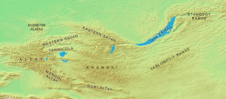
the mountain range
The Khangai Mountains form a range in central Mongolia, some 400 km west of Ulaanbaatar.
Name
Two provinces of Mongolia are named after the Khangai mountains: Arkhangai (North Khangai) and Ovorkhangai (South Khangai). The mild climate area where the two provinces meet (in eastern Khangai) is known as the cradle of Mongolian and nomadic civilization. The plains at the foot of the eastern Khangai host the Orkhon Valley World Heritage Site. The Xiongnu capital Luut Khot (Lungcheng), the Xianbei capital Ordo and the Rouran capital Moomt (Mume) are said to have been located there. Later empires also established their capitals there: e.g. the Uyghur Khaganate (745–840) built their capital Ordu-Baliq in the region.
Features
The tallest mountain is Otgontenger (lit. "Youngest sky"), which is about 4,000 metres high. It is revered by the Mongols and state ceremonies are held there. Otgontenger is considered sacred by ancient Turks.
Suvraga Khairkhan, 3,117 metres tall, is another sacred mountain to the east of Tsetserleg.
Taryatu-Chulutu is an extinct volcanic field on the northern slopes of the Khangai Mountains.
The mountains feed the rivers Orkhon, Selenge, Ider, Zavkhan and the lakes Orog and Böön Tsagaan. In the west, the Khangai mountains transition into the Great Lakes Depression.
The Khangai mountain region is known for its mild microclimates in certain areas. Winters there are not as harsh as in other parts of the country.
Because of strong winter inversions which have become known as a singularity of the mesoclimate of Mongolia (Gavrilova 1974) the Khangai tends to be some 10°C warmer than the surrounding areas. It is likely that even the highest mountain tops are some 5°C warmer than the sub-Khangai basins.
Notes
References
References
- (2018-07-21). "Relict topography within the Hangay Mountains in central Mongolia: Quantifying long-term exhumation and relief change in an old landscape". Tectonics.
- [http://rcin.org.pl/igipz/Content/606/Wa51_5397_r1980-nr136_Prace-Geogr.pdf Vertical Variability of Climatic Conditions in the Khangai Mountains] (1980). Brzezniak, Eligiusz; Niedzwiedz, Tadeusz. p.34.
This article was imported from Wikipedia and is available under the Creative Commons Attribution-ShareAlike 4.0 License. Content has been adapted to SurfDoc format. Original contributors can be found on the article history page.
Ask Mako anything about Khangai Mountains — get instant answers, deeper analysis, and related topics.
Research with MakoFree with your Surf account
Create a free account to save articles, ask Mako questions, and organize your research.
Sign up freeThis content may have been generated or modified by AI. CloudSurf Software LLC is not responsible for the accuracy, completeness, or reliability of AI-generated content. Always verify important information from primary sources.
Report