From Surf Wiki (app.surf) — the open knowledge base
Kent Plateau
Mountain in Ross Dependency, Antarctica
Mountain in Ross Dependency, Antarctica
| Field | Value |
|---|---|
| photo | File:Nicholson Peninsula USGS Satellite Image.jpg |
| photo_caption | Satellite Image Map of Nicholson Peninsula and surroundings. Byrd Glacier to the northeast. Kent Plateau center west. |
| map | Antarctica |
| coordinates | |
| native_name | |
| native_name_lang | |
| location | Antarctica |
| country_type | Continent |
| country | |
| state | |
| region | Ross Dependency |
| district | |
| part | |
| settlement_type | Use settlement_type= instead of city_type= (deprecated). |
| settlement | |
| range | Churchill Mountains |
The Kent Plateau () is an ice-covered plateau in the northern extreme of the Churchill Mountains of Antarctica.
Name
Kent Plateau was named by the Advisory Committee on Antarctic Names for Commander Donald F. Kent, U.S. Navy, logistics officer to Admiral Dufek at the outset of U.S. Navy Operation Deep Freeze I, 1955–56.
Location
The Kent Plateau is an ice-covered plateau, 12 mi long and 4 mi wide, extending northward from Mount Egerton and Kiwi Pass to the vicinity of Mount Hamilton. The plateau is on the west of a ridge of mountains that runs north from Mount Durnford, dips at Kiwi Pass, then continues north from Mount Moa to Mount Hamilton along the east edge of the plateau. To the west of the plateau along the southeast edge of the Byrd Glacier there is a chain of mountains broken by glaciers that flow down from the plateau region to Byrd Glacier.
Glaciers
Several short glaciers run down from the plateau into Byrd Glacier. From southwest to northeast they are:
Zeller Glacier
Main article: Zeller Glacier
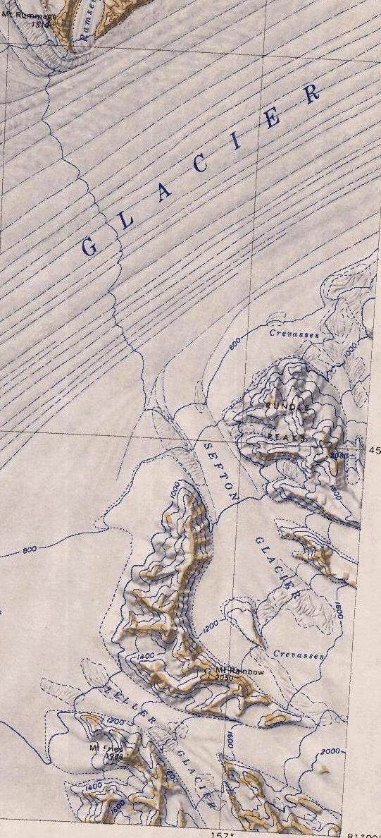
Sefton Glacier
Main article: Sefton Glacier
Twombley Glacier
Main article: Twombley Glacier
A glacier 6 mi long, flowing from the north side of the Kent Plateau into the south side of Byrd Glacier. Named by US-ACAN for C.E. Twombley of the U.S. Weather Bureau, a member of the Little America V winter party, 1956.
Brecher Glacier
Main article: Brecher Glacier
Judith Glacier
Main article: Judith Glacier
Nearby features to the east
Nearby features to the east include, from south to north:
Mount Morse
Kiwi Pass
Mount Moa
Mount Hamilton
Cupcake Peaks
Nearby features to the west and north

Nearby features to the west and north, along the southern edge of the Byrd Glacier, include from southwest to northeast, Keating Massif, Mount Fries, Zeller Glacier, Mount Rainbow, Sefton Glacier, the Rundle Peaks, Brecher Glacier, Mandarich Massif, Twombley Glacier, Blake Massif, Lowry Massif, Mount Tuatara, Judith Glacier, Mount Tadpole, the Miscast Nunataks and Couzens Saddle. Roberts Pike and Carr Crest are isolated features to the east of Lowry Massif.
Keating Massif
Mount Fries
A prominent peak, 1,985 m high, standing just south of the mouth of Zeller Glacier and being one of the westernmost summits along the south wall of Byrd Glacier. Named by US-ACAN for Robert H. Fries, aurora scientist at the South Pole Station, 1963.
Mount Rainbow
Rundle Peaks
Mandarich Massif
Blake Massif
Lowry Massif
Mount Tuatara
Mount Tadpole
Miscast Nunataks
Couzens Saddle
A saddle rising to approximately 500 m, between the Miscast Nunataks and Mount Madison at west and east, and Byrd Glacier and Couzens Bay at north and south. It was named at the suggestion of the US Advisory Committee on Antarctic Names, in association with Couzens Bay, which was named by the New Zealand Geological Survey Antarctic Expedition (1960–61) in honor of Lieutenant Thomas Couzens, Royal New Zealand Air Force, who lost his life in a crevasse accident near Cape Selborne on 19 November 1959.
Roberts Pike
Carr Crest
References
Sources
- {{citation|url=https://pubs.usgs.gov/fedgov/70039167/report.pdf |accessdate=2023-12-03 |edition=2 |editor-last=Alberts |title=Geographic Names of the Antarctic |editor-first=Fred G.
- {{cite gnis2 |type = antarid |id = 18485
- {{cite gnis2 | type = antarid | id = 18253
- {{citation |url=https://commons.wikimedia.org/wiki/File:C80195s1_Ant.Map_Cape_Selborne.jpg |accessdate=2023-12-17 |publisher=USGS United States Geologic Survey
- {{cite gnis2 |type = antarid |id = 18489
- {{cite gnis2 |type = antarid |id =18490
- {{cite gnis2 | type = antarid | id = 18267
- {{cite gnis2 |type = antarid |id = 18290
- {{cite gnis2 |type = antarid |id =18498
- {{cite gnis2 |type = antarid |id =18292
- {{cite web|title=On Yachting; Peter Blake's Legacy Spans the World|url=https://query.nytimes.com/gst/fullpage.html?res=9F03EED9133CF934A35751C1A9679C8B63|first=Herb
- {{cite gnis2 |type = antarid |id = 18295
- {{cite gnis2 |type = antarid |id =18505
- {{cite gnis2 |type = antarid |id = 18525
- {{citation |url=https://commons.wikimedia.org/wiki/File:C80202s5_Ant.Map_Mount_Olympus.jpg |accessdate=2023-12-17 |publisher=USGS United States Geologic Survey
- {{cite gnis2 |type = antarid |id =18308
- {{citation |url=https://en.wikipedia.org/wiki/File:Nicholson_Peninsula_USGS_Satellite_Image.jpg |accessdate=2023-12-20
- {{cite gnis2 |type = antarid |id =18301
This article was imported from Wikipedia and is available under the Creative Commons Attribution-ShareAlike 4.0 License. Content has been adapted to SurfDoc format. Original contributors can be found on the article history page.
Ask Mako anything about Kent Plateau — get instant answers, deeper analysis, and related topics.
Research with MakoFree with your Surf account
Create a free account to save articles, ask Mako questions, and organize your research.
Sign up freeThis content may have been generated or modified by AI. CloudSurf Software LLC is not responsible for the accuracy, completeness, or reliability of AI-generated content. Always verify important information from primary sources.
Report