From Surf Wiki (app.surf) — the open knowledge base
Karakax County
County in Xinjiang, China

County in Xinjiang, China
| Field | Value |
|---|---|
| name | Karakax County |
| native_name | |
| other_name | |
| pushpin_map | China Xinjiang Southern#Xinjiang#China |
| pushpin_label_position | right |
| pushpin_map_caption | Location within Xinjiang |
| pushpin_mapsize | 275 |
| coordinates | |
| settlement_type | County |
| image_skyline | Mazar Tagh BLP471 PHOTO1125 16 479.jpg |
| image_caption | Mazar Tagh |
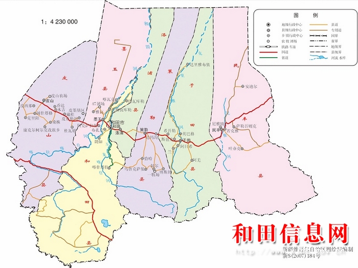
| image_map | Location of Karakash within Xinjiang (China).png |
| map_caption | Location of Karakax County (red) within Hotan Prefecture (yellow) and Xinjiang |
| subdivision_type | Country |
| subdivision_name | China |
| subdivision_type1 | Autonomous region |
| subdivision_name1 | Xinjiang |
| subdivision_type2 | Prefecture |
| subdivision_name2 | Hotan |
| seat_type | County seat |
| seat | Karakax Town |
| area_total_km2 | 25788.86 |
| area_footnotes | |
| population_footnotes | |
| population_total | 571,648 |
| population_as_of | 2020 |
| population_density_km2 | auto |
| population_density_urban_km2 | auto |
| demographics_type2 | Ethnic groups |
| demographics2_title1 | Major ethnic groups |
| demographics2_info1 | Uyghur, Han Chinese |
| timezone | China Standard |
| utc_offset | +8 |
| postal_code_type | Postal code |
| postal_code | 848100 |
| website |
| ibox-order = ug, zh
Karakax County (, also transliterated as Qaraqash; ), also known as Moyu County (), is a county in the Xinjiang Uyghur Autonomous Region and is located in the southern edge of the Tarim Basin, it is under the administration of the Hotan Prefecture. It contains an area of 25667 km2. According to the 2011 census it has a population of 577,000 and 98,1% are Uyghurs. The county is bordered to the north by Awat County in Aksu Prefecture, to the northeast by Lop County, to the southeast by Hotan County, to the northwest by Maralbexi County in Kashgar Prefecture, and to the southwest by Pishan County and Kunyu. Exclaves of Kunyu are located within the county.
History
In the Late Qing dynasty, the area that would become Karakax County was divided into four ming (明) (Mandarin Chinese Hanyu Pinyin-derived names): Hayashi (哈雅什明), Buhua (布華明), Makuiya (馬奎牙明), and Kuiya (奎牙明). On the eve of the creation of the county, the area was divided into six ming (明): Zhawa (扎瓦明), Ying'ai (英愛明) (also known as Tahe (塔合明)), Balamusu (巴拉木蘇明), Kuiya (奎牙明), Makuiya (馬奎牙明), and Ka'ersai (喀爾賽明).
In 1919, the county was split off from Hotan County.
In October 1984, the people's communes in the county were replaced with towns and townships.
In 2012, Zawa (Zhawa) was changed from a township into a town.
In 2013, Kuya (Kuiya) was changed from a township into a town.
On February 13, 2014, Qarasaz (Ka'ersai) was changed from a township into a town.
On the morning of June 20, 2014, five police officers at a security checkpoint in Kayash village in Manglay township were found dead killed by unknown assailants. The security checkpoint, known as a place where women wearing headscarves and men wearing beards would be interrogated, was razed to the ground.
At 3 AM on July 19, 2014, the day after a raid at a local mosque, Zeynep Memtimin, wife of party secretary Rejep Islam, was killed by unknown assailants in an attack at their home. Islam was severely injured and left for dead, but survived.
In December 2016, the Communist Party office in Karakax County was reportedly attacked by assailants using knives and improvised explosive devices, leading to the deaths of two government employees and three assailants.
In 2017, the county was divided between four and later five main district area committees (大片区管委会).
In May 2017, Abduheber Ahmet, the imam of the Dongbagh Mosque in Urchi township, was arrested for bringing his son to an underground religious school on one occasion several years before the arrest. Because Ahmet admitted that the events took place, Ahmet was sentenced to five and a half years in prison instead of seven years.{{cite web |author-link=Shohret Hoshur |archive-url=https://web.archive.org/web/20180510235805/https://www.rfa.org/english/news/uyghur/imam-05102018155405.html |archive-date=May 10, 2018
In February 2020 dissidents leaked the hacked records of 311 detained Uyghurs from a single neighborhood in Karakax County.
Geography
The populated part of Karakax county is located at the northern edge of the Karakoram mountains and southern part of Tarim Basin (Taklamakan Desert). The Karakax river separates the county from Hotan County and the Hotan River separates the county from Lop County. The length from south to north is 320 km and width from east to width is 51 km. Mazartag is a prominent arc-shaped mountain range in the northern desert area of the county.
File:Txu-oclc-6654394-nj-44-3rd-ed.jpg|Map including Karakax (labeled as MO-YÜ (KARAKASH)) and surrounding region (USATC, 1971) File:NJ-44-2 K'O-P'A-CHIA-LO-K'O China.jpg|Map including part of northern Karakax (Moyu) County (ATC, 1971) File:Johnson-journey-ilchi1865-mapa.jpg|Map including Kárakásh (1865)
Climate
|Jan record high C = 21. |Jan record low C = -22.5 |Feb record high C = 22.1 |Feb record low C = -22.3 |Mar record high C = 31.0 |Mar record low C = -8.8 |Apr record high C = 35.5 |Apr record low C = -0.5 |May record high C = 37.5 |May record low C = 2.9 |Jun record high C = 39.9 |Jun record low C = 8.3 |Jul record high C = 40.7 |Jul record low C = 10.5 |Aug record high C = 39.2 |Aug record low C = 7.9 |Sep record high C = 35.3 |Sep record low C = 2.4 |Oct record high C = 29.9 |Oct record low C = -5.9 |Nov record high C = 26.0 |Nov record low C = -13.5 |Dec record high C = 18.8 |Dec record low C = -21.7
Administrative divisions
Karakax county is subdivided into the following 5 towns and 11 townships:
| Name | Simplified Chinese | Hanyu Pinyin | Uyghur (UEY) | Uyghur Latin (ULY) | Administrative division code | Notes | |
|---|---|---|---|---|---|---|---|
| Towns | |||||||
| Karakax Town | 喀拉喀什镇 | zh | قاراقاش بازىرى | ug | 653222100 | ||
| Zawa Town | |||||||
| (Cha-wa) | 扎瓦镇 | zh | زاۋا بازىرى | ug | 653222101 | ||
| Kuya Town | 奎牙镇 | zh | كۇيا بازىرى | ug | 653222102 | ||
| Qarasay Town | 喀尔赛镇 | zh | قاراساي بازىرى | ug | 653222103 | ||
| Purchaqchi Town | 普恰克其镇 | zh | پۇرچاقچى بازىرى | ug | 653222104 | formerly Purchaqchi Township (پۇرچاقچى يېزىسى / 普恰克其乡) | |
| Townships | |||||||
| Aqsaray Township | 阿克萨拉依乡 | zh | ئاقساراي يېزىسى | ug | 653222203 | ||
| Urchi Township | 乌尔其乡 | zh | ئۇرچى يېزىسى | ug | 653222204 | ||
| 32FA8856C1EF3774E0440003BA962ED3 | Tohula (Approved - N)}}, United States National Geospatial-Intelligence Agency | 托胡拉乡 | zh | توخۇلا يېزىسى | ug | 653222205 | |
| 32FA8856C1EA3774E0440003BA962ED3 | Saybagh (Approved - N)}}, United States National Geospatial-Intelligence Agency | 萨依巴格乡 | zh | سايباغ يېزىسى | ug | 653222206 | |
| Jahanbagh Township | 加汗巴格乡 | zh | جاھانباغ يېزىسى | ug | 653222207 | ||
| Manglay Township | 芒来乡 | zh | ماڭلاي يېزىسى | ug | 653222209 | ||
| Qochi Township | 阔依其乡 | zh | قوچى يېزىسى | ug | 653222210 | ||
| Yawa Township | |||||||
| (Ya-wa) | 雅瓦乡 | zh | ياۋا يېزىسى | ug | 653222211 | ||
| 32FA882681C13774E0440003BA962ED3 | Tüwat (Approved - N)}}, United States National Geospatial-Intelligence Agency | 吐外特乡 | zh | تۈۋەت يېزىسى | ug | 653222212 | |
| Yéngiyer Township | 英也尔乡 | zh | يېڭىيەر يېزىسى | ug | 653222213 | ||
| Kawak Township | 喀瓦克乡 | zh | كاۋاك يېزىسى | ug | 653222214 |
Economy
.jpg)
The county produces cotton, corn, wheat, melons, silkworm cocoons, black jade and walnuts. Industries include cotton ginning, food processing, tractors and carpet making.
Demographics
|2000|405634 |2010|500114 |}} As of 2015, Uyghurs made up 97.61% of the population of the county. Han Chinese made up 2.34% of the population.
As of 1999, 98.53% of the population of Karakax (Moyu) County was Uyghur and 1.44% of the population was Han Chinese.
Transportation
Karakax county has daily bus and taxi to Hotan and other counties like Guma, and also has direct luxury buses to Ürümchi, which is the capital city of Xinjiang, Karakax is also served by China National Highway 315 and the Kashgar-Hotan Railway.
A long, straight special-use road (专用道) enters the Taklamakan Desert northwest of Dunkule village (墩库勒村) in Kawak (Kawake) township. The road turns near a ridge and terminates near buildings. The area is near Mazar Tagh (Ma-cha-t'a-ko, Mazartag; مازار تاغ / 麻扎塔格戌堡遗址).
Notes
References
References
- [http://www.citypopulation.de/en/china/xinjiang/admin/ Xinjiang: Prefectures, Cities, Districts and Counties]
- link. (6 January 2011). zh-hans. 和田地区辖县。面积23098.5平方千米,人口37.3万,有维吾尔、汉、回、壮等民族,其中维吾尔族占98.7%,汉族占1.3%,辖1镇15乡。
- Sasha Chavkin. (19 February 2020). "New Leak Shows How China Targets Uighurs in Xinjiang".
- Ben Westcott. (26 February 2020). "Chinese government disputes Xinjiang detention records leaked to CNN".
- (2004). "Records of Xinjiang Ground-jay Podoces biddulphi in Taklimakan Desert, Xinjiang, China".
- link. (13 February 2018). zh-hans. 民国2年(1913)改和阗直隶州为和阗县,今墨玉县属和阗县管辖。民国8年(1919)成立墨玉县。{{Dead link. (August 2025)
- Shohret Hoshur. (22 June 2014). "Five Police Officers Killed in Attack on Xinjiang Security Checkpoint".
- Shohret Hoshur. (30 July 2014). "Wife of Party Official Killed in Xinjiang 'Revenge Attack'".
- Watt, Louise. (December 29, 2016). "China: Police shoot dead 3 who killed 2 in Xinjiang attack". [[The Washington Post]].
- Hernández, Javier C.. (December 29, 2016). "China Says 5 Killed in Attack at Communist Party Office in Xinjiang". [[The New York Times]].
- Ng, Teddy. (December 29, 2016). "Five dead in car bomb terror attack in China's western Xinjiang region, official media reports". [[South China Morning Post]].
- link. (13 February 2018). zh-hans. 1984年,和田地区各县市撤社建乡,政社分开。1984年10月,墨玉县实行社改乡制,撤销人民公社,建立乡镇,成立乡镇人民政府和党委;撤销大队、生产队,建立村民委员会、村民小组。墨玉县下辖1镇16乡。{...}2012~2014年,墨玉县陆续开展撤乡建镇,先后成立扎瓦镇、奎雅镇和喀尔赛镇3个镇。{...}2017年5月,墨玉县新建4个片区管委会,即第一、第二、第三、第四片区管委会(其乃巴格街道、斯孜街道、波斯坦街道以及城区新拆分管委会);同月,新建11个社区(没有编办成立文件)。每个片区管委会下辖8个社区,224团社区单独设立,不隶属于新建的4个片区管委会。 2017年6月,墨玉县委将全县划分为5个大片区管委会,下辖31个乡镇、街道、园区和拆分的小管委会。第一大片区管委会下辖1个乡镇、3个街道和1个管委会。第二片区管委会下辖4个乡镇、4个管委会。第三大片区管委会下辖3个乡镇、2个管委会。第四大片区管委会下辖4个乡镇和3个管委会。第五大片区管委会下辖4个乡镇和2个管委会。 截至2017年7月,墨玉县辖5个大片区管委会,大片区管委会下辖4镇12乡12个管委会362个行政村,4个片区管委会33个社区。
- Ivan Watson. (17 February 2020). "Watched, judged, detained". [[CNN]].
- link. [[China Meteorological Administration]]
- link. XZQH.org. (2 December 2014). zh-hans. 2000年第五次人口普查,墨玉县常住总人口405634人,{...}2003年,全县总面积25788.86平方千米,{...}2010年第六次人口普查,墨玉县常住总人口500114人,其中:喀拉喀什镇31332人,喀尔塞乡40892人,奎牙乡43212人,扎瓦乡52165人,阿克萨拉依乡27352人,乌尔其乡16400人,托胡拉乡18800人,萨依巴格乡32355人,加汗巴格乡24524人,普恰克其乡35142人,芒来乡23408人,阔依其乡26346人,雅瓦乡33949人,吐外特乡24685人,英也尔乡11485人,瓦克乡10992人,其尼巴格街道13810人,波斯坦街道11877人,斯孜街道9522人,兵团四十七团3699人,兵团二二四团8167人。 2012年,自治区政府(新政函[2012]28号)批准同意撤销扎瓦乡,设立扎瓦镇。2013年,自治区政府(新政函[2013]140号)批准同意撤销奎牙乡,设立奎牙镇。 2014年2月13日,喀尔赛乡正式撤乡建镇。调整后,全县辖4个镇、12个乡:喀拉卡什镇、扎瓦镇、奎牙镇、喀尔赛镇、阿克萨拉依乡、乌尔其乡、托胡拉乡、萨依巴格乡、加汗巴格乡、普恰克其乡、芒来乡、阔依其乡、雅瓦乡、吐外特乡、英也尔乡、喀瓦克乡。
- link. [[National Bureau of Statistics of the People's Republic of China]]. (2018). zh-hans. 统计用区划代码 名称 653222100000 喀拉喀什镇 653222101000 扎瓦镇 653222102000 奎牙镇 653222103000 喀尔赛镇 653222104000 普恰克其镇 653222203000 阿克萨拉依乡 653222204000 乌尔其乡 653222205000 托胡拉乡 653222206000 萨依巴格乡 653222207000 加汗巴格乡 653222209000 芒来乡 653222210000 阔依其乡 653222211000 雅瓦乡 653222212000 吐外特乡 653222213000 英也尔乡 653222214000 喀瓦克乡 653222500000 兵团四十七团 653222501000 兵团二二四团
- link. (13 February 2018). zh-hans. 新中国成立前行政区划:清末,墨玉设有4明(千户):哈雅什明、布华明、马奎牙明、奎牙明。建县前夕,由4明扩至6明,即扎瓦明、英爱明(又称塔合明)、巴拉木苏明、奎牙明、马奎牙明、喀尔赛明。{...}2015年7月,全县辖4镇12乡3个街道办事处,即墨玉镇、扎瓦镇、奎牙镇、喀尔赛镇、托胡拉乡、加汗巴格乡、阿克萨拉依乡、萨依巴格乡、乌尔其乡、雅瓦乡、芒来乡、普恰克其乡、阔依其乡、吐外特乡、英也尔乡、喀瓦克乡、其乃巴格街道办事处、波斯坦街道办事处、斯孜街道办事处。
- (1971). "NJ 44 Ho-tien". [[U.S. Army Topographic Command]].
- {{GEOnet2. 32FA8856C1EF3774E0440003BA962ED3. Tohula (Approved - N), [[National Geospatial-Intelligence Agency. United States National Geospatial-Intelligence Agency]]
- {{GEOnet2. 32FA8856C1EA3774E0440003BA962ED3. Saybagh (Approved - N), [[National Geospatial-Intelligence Agency. United States National Geospatial-Intelligence Agency]]
- link. (14 January 2020). ug. قاراقاش ناھىيەسى جاھانباغ يېزىسى. (August 2025)
- {{GEOnet2. 32FA882681C13774E0440003BA962ED3. Tüwat (Approved - N), [[National Geospatial-Intelligence Agency. United States National Geospatial-Intelligence Agency]]
- (September 2009). [[Shanghai Lexicographical Publishing House]]. [[Shanghai Lexicographical Publishing House]].. zh-hans. 面积2.58万平方千米。人口47万(2006年)。{...}1919年由和阗县(今和田县)析置。以产墨玉得名。{...}为南疆重要棉花、玉米、小麦、瓜果产区。盛产蚕茧,特产黑玉石、核桃。工业有轧棉、食品加工、农机、制毯等。
- link. (13 February 2018). zh-hans. 2015年,墨玉县境内(包括47团、224团)有维吾尔族563 606人,占总人口的97.61%;有汉族13 522人,占总人口的2.34%;{{Dead link. (March 2025)
- (2004). "Governing China's Multiethnic Frontiers". [[University of Washington Press]].
- (2012). "20120719105550523.jpg".
- (1971). "NJ 44 Ho-tien [China, India] Series 1301, Edition 3-TPC". [[U.S. Army Topographic Command]].
- {{GEOnet2. F72C9F4257B806CEE04317F7D6A454CC. Mazatagexu Baoyizhi (Approved - N), [[National Geospatial-Intelligence Agency. United States National Geospatial-Intelligence Agency]]
- link. (12 February 2018). 电子政务办公室
This article was imported from Wikipedia and is available under the Creative Commons Attribution-ShareAlike 4.0 License. Content has been adapted to SurfDoc format. Original contributors can be found on the article history page.
Ask Mako anything about Karakax County — get instant answers, deeper analysis, and related topics.
Research with MakoFree with your Surf account
Create a free account to save articles, ask Mako questions, and organize your research.
Sign up freeThis content may have been generated or modified by AI. CloudSurf Software LLC is not responsible for the accuracy, completeness, or reliability of AI-generated content. Always verify important information from primary sources.
Report