From Surf Wiki (app.surf) — the open knowledge base
Jhelum
City in Punjab, Pakistan
City in Punjab, Pakistan
| Field | Value | |||||
|---|---|---|---|---|---|---|
| name | Jhelum | |||||
| native_name | ||||||
| native_name_lang | ur | |||||
| settlement_type | City | |||||
| translit_lang1_info2 | ||||||
| translit_lang2_info2 | ||||||
| <!--images, nickname, motto--> | image_skyline | {{multiple image | total_width=280px | perrow=1/2/2/2 | border=infobox | caption_align = center |
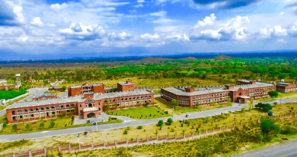
| image1 | PujcAnnotation_2020-05-30_171638.jpg | |||||
| caption1 | University of the Punjab, Jhelum | |||||
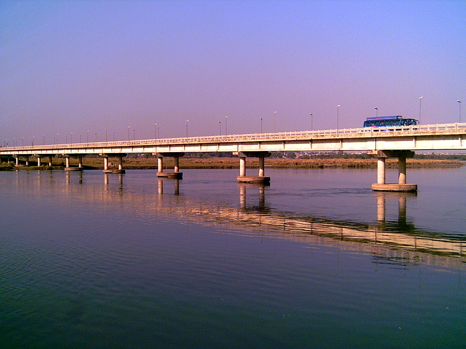
| image2 | Jhelum_River_Bridge.JPG | |||||
| caption2 | Jhelum Bridge | |||||
| image3 | Mosque_in_Jhelum_Cantonment_Pakistan.jpg | |||||
| caption3 | Cantonment Mosque | |||||
| image4 | Railway_Station_Jhelum_Inner_View.jpg | |||||
| caption4 | Jhelum railway station | |||||
| image5 | St._John%27s_Church_Jhelum1.JPG | |||||
| caption5 | St. John's Church | |||||
| image6 | Jhelum_Cricket_Stadium_Panorama.JPG | |||||
| caption6 | Jhelum Cricket Stadium | |||||
| imagesize | 250 | |||||
| nicknames | *City of Soldiers* | |||||
| *Land of Martyrs and Warriors* | ||||||
| image_map | Map of Jhelum.jpg | |||||
| mapsize | 250px | |||||
| map_caption | Map of Jhelum City | |||||
| pushpin_map | Punjab Pakistan#Pakistan | |||||
| pushpin_label_position | left | |||||
| pushpin_mapsize | 250 | |||||
| pushpin_map_caption | Location within Punjab, Pakistan | |||||
| coordinates | ||||||
| coor_pinpoint | ||||||
| coordinates_footnotes | ||||||
| <!--location--> | subdivision_type | Country | ||||
| subdivision_name | Pakistan | |||||
| subdivision_type1 | Province | |||||
| subdivision_name1 | Punjab | |||||
| subdivision_type2 | Division | |||||
| subdivision_name2 | Rawalpindi | |||||
| subdivision_type3 | District | |||||
| subdivision_name3 | Jhelum | |||||
| <!--established--> | established_title | Founded | ||||
| established_date | Before BC | |||||
| established_title1 | ||||||
| established_title2 | ||||||
| demographics_type1 | Languages | |||||
| demographics1_title1 | Official | |||||
| demographics1_info1 | ||||||
| demographics1_title3 | Spoken | |||||
| demographics1_info3 | Punjabi (89%) | |||||
| Urdu (4%) | ||||||
| Pashto (3%) | ||||||
| *others* (4%) | ||||||
| named_for | ||||||
| seat_type | Municipal Corporation | |||||
| parts_type | Union Councils | |||||
| parts_style | ||||||
| parts | 7 | |||||
| p2 | ||||||
| leader_title | Mayor | |||||
| leader_name | None (vacant) | |||||
| leader_title1 | Deputy Commissioner | |||||
| leader_name1 | Samiullah Farooq (PAS) | |||||
| leader_title2 | District Police Officer | |||||
| leader_name2 | Nasir Mehmood Bajwa (PSP) | |||||
| unit_pref | ||||||
| area_magnitude | ||||||
| area_total_km2 | 22.5 | |||||
| area_total_sq_mi | ||||||
| area_total_dunam | ||||||
| area_blank2_sq_mi | ||||||
| elevation_m | 233 | |||||
| elevation_ft | 768 | |||||
| elevation_footnotes | {{cite web | |||||
| url | http://www.weatherbase.com/weather/weather.php3?s=415980&refer=&units=metric | title =Weatherbase: Historical Weather for Jhelum, Pakistan | publisher=Weatherbase website}} | |||
| <!--population--> | population_blank1_title | Demonym | ||||
| population_blank1 | Jhelumi | |||||
| population_footnotes | ||||||
| population_total | 312,426 | |||||
| population_as_of | [2023](2023-pakistani-census) | |||||
| total_type | City | |||||
| population_rank | 31st, Pakistan | |||||
| 21st, Punjab | ||||||
| population_note | ||||||
| demographics1_footnotes | ||||||
| demographics2_info1 | ||||||
| <!--time zone(s)--> | timezone1 | PKT | ||||
| utc_offset1 | +5 | |||||
| utc_offset2_DST | ||||||
| postal_code_type | Postal code | |||||
| postal_code | 49600 | |||||
| postal2_code_type | ||||||
| area_code_type | Dialling code | |||||
| area_code | 0544 |
Land of Martyrs and Warriors Urdu (4%) Pashto (3%) others (4%) 21st, Punjab Jhelum (also known as Jehlum) (; Punjabi / Urdu: {{unq|جہلم}}) is a city on the western bank of the Jhelum River in Punjab, Pakistan. Located in northern Punjab, it is the capital of the Jhelum District. The city is nicknamed the "City of Soldiers" or "Land of Martyrs and Warriors" since many soldiers from the area serving in the British Indian Army and later, the Pakistan Armed Forces. Due to this, Punjabi tribes have been characterized as a 'martial race'.
Jhelum is several miles upstream from the site of the ancient Battle of the Hydaspes between the armies of Alexander III of Macedon and Porus. The location of the modern city of Jhelum could conceivably have been the site of the capital of Paurava. The name of the nearby city Bucephala commemorates the death of Alexander's horse, Bucephalus. Other notable areas nearby include the 16th-century Rohtas Fort, and the Tilla Jogian complex of ancient temples. The 16th-century Grand Trunk Road, passes through the city. According to the 2023 Pakistani census, the population of Jhelum was 312,426. Today, there are a number of industries in Jhelum, including a tobacco factory and wood, marble, glass and flour mills.
Etymology
According to the Concise Dictionary of World-Place Names, the name Jehlum is derived from Jal meaning ‘pure water’ and Ham meaning ‘snow’. This refers to the water flowing through the Jhelum River that originates from the snow-covered Himalayas.Historian Anjum Sultan Shahbaz recorded some theories about the name Jhelum in his book Tareekh-e-Jhelum thus:
However, some writers believe that when "Dara-e-Azam" reached a certain place on the river bank after winning many battles, he fixed his flag at that place and called it "Ja-e-Alam" which means "Place of the Flag". With the passage of time it became Jhelum from "Ja-e-Alam".
According to tradition, Saeed Bin Abi Waqas, brother of Saad Bin Abi Waqas, was sent to China to preach Islam, during his journey he arrived at the city of Jhelum, he saw the reflection of a city in the river and said "هذا جهيلم" (this is Jhelum), which means "City besides the river, in full moonlight".
Ahmed Shah Abdali also used "Jheelum" in place of Jhelum and "Harian" for Kharian in his diary.
History
Ancient
Rajput, Gurjar, Labana, and Arain settlers comprised the earliest inhabitants of Jhelum. The city, established in the Salt Range and its northern plateau, is known historically as the site of the Battle of the Hydaspes between Alexander III of Macedon and the local ruler of the region, Porus the Elder. Abisares (or Abhisara;{{cite encyclopedia | author-link = Hugh Chisholm Oβισαρoς) by Diodorus, was an Indian king of the Abhira tribe. His descent was beyond the river Hydaspes, whose territory lay in the mountains. He sent embassies to Alexander both before and after the conquest of Porus in 326 BC, although he was inclined to espouse the side of the latter. Alexander not only allowed him to retain his kingdom but also expanded it, and upon his death, appointed his son as his successor. Porus' kingdom, Paurava, was on the left bank of the Jhelum River, corresponding to the limits of the present Gujrat District. The Gakhars appear to represent an early wave of conquerors from the west, who still inhabit a large tract in the mountains north of the Tilla range. Gakhars were the dominant race during the early Muslim era, and they continued to retain their independence for a long period, both in Jhelum and in the neighboring district of Rawalpindi.
Medieval
In 997 CE, Sultan Mahmud Ghaznavi took over the Ghaznavid dynasty empire established by his father, Sultan Sebuktegin. In 1005, he conquered the Shahis in Kabul and followed it by conquests of the Punjab region, including Jhelum. The Delhi Sultanate and later the Mughal Empire ruled the area. The Punjab region became predominantly Muslim due to missionary Sufi saints whose dargahs dot the landscape.
The Mughals were Persianized Turks who claimed descent from both Timur and Genghis Khan and strengthened the Persianate culture of Muslim India. Being very few in number, the main families of Mughal Barlas, descendants of Amir Timur, settled in Mong Rasool and afterward scattered to the villages of Chak Nazar, Shamaspur, Aima Afghana, Khardiyala, Chak Sikander, Malhar Muglain, Mota Garbi, and Bhimber. They adopted a policy of converting the local Jats and Gakhars, which was mandatory, as recorded in the Baburnama.{{cite web |access-date = 24 July 2021 |url-status = dead |archive-url = https://web.archive.org/web/20060117163845/http://www.poemhunter.com/abdur-rahim-khankhana/biography/poet-33381/ |archive-date = 17 January 2006
Later periods
After the decline of the Mughal Empire, the region fell to the Durrani Empire. After the Third Battle of Panipat, the newly emerging Sikh Empire invaded and occupied the Jhelum District in 1808 from its Gakhar ruler, Raja Sultan Muqarrab Khan. In 1849, Jhelum passed with the rest of the Sikh territories to the British Raj. The British conquered Jhelum in 1849 with the assistance of the local Gakhars who resented Sikh rule. [[File:A Fort in Jhelum City.jpg|thumb|A [[Sikh Empire|Sikh]]-era fort in Jhelum City]]
British Raj
During British rule, Jhelum was connected by the North-Western Railway to other cities in the Indian Empire: 1,367 miles from Calcutta, 1,413 from Bombay, and 849 from Karachi. According to the 1901 census, the population was 14,951 people.
The Imperial Gazetteer of India described Jhelum:
During the Mutiny of 1857, 35 British soldiers of the Regular 24th Regiment of Foot were killed at the Battle of Jhelum by mutineers from the Honourable East India Company's 14th Bengal Native Infantry (roughly 500 of the soldiers mutinied, with roughly 100 of the Sikh soldiers remaining loyal). Among the dead was Captain Francis Spring, the eldest son of Colonel William Spring. A lectern inside St John's Church shows the names of those 35 soldiers. St John's Church is located beside the river Jhelum and remains a landmark in the city. It was built in 1860 as a Protestant church and was in use throughout the British period. For forty years, it was closed to the public and in poor condition; however, in 2007, it was renovated and reopened and is now maintained.
The British soldier William Connolly won a Victoria Cross for his bravery during this battle. Mirza Dildar Baig, also known as Khaki Shah, took part in the mutiny at Jhelum and was later celebrated by Indian Nationalists. He was captured and arrested with the remaining mutineers by authorities in Kashmir and later hanged near the river Jhelum. His grave is in a shrine in Jhelum Dildarnagar, and a small town in Uttar Pradesh is also named after him.
The railway bridge on the river Jhelum was built in 1873 by the British engineer William St. John Galwey. He also made the great Empress Victoria Bridge over the river Sutlej. During World War I, the Jhelum District "stood first" among districts in recruiting for the British war effort, with greater financial assistance from the British government channeled into the area in return.
Independence
The predominantly Muslim population supported the Muslim League and the Pakistan Movement. After the independence of Pakistan in 1947, the minority Hindus and Sikhs migrated to India, while Muslim refugees from India settled down in the Jhelum District.
Administration
As well as being district capital, Jhelum city is also the headquarters of Jhelum Tehsil. The city of Jhelum is administratively subdivided into seven union councils: Jhelum-I, Jhelum-II, Jhelum-III, Jhelum-IV, Jhelum-V, Jhelum-VI and Jhelum-VII.
Demographics
As of the 2023 census of Pakistan, the population of Jhelum city, including the Jhelum cantonment, was about 312,426 people. It is the 31st-largest city of Pakistan with respect to population. The total area of the city is about 22 km2. The population density is 261 people per sq. km, and the population growth rate is 1.51, which is very low compared to other urban areas of Pakistan. The majority of the population, 98.47%, percent is Muslim. Of the minorities in Jhelum, Christians are the largest, making up 1.36% of the district's population.
The literacy rate of Jhelum is among the highest in Pakistan. At 79%, it is only lower than that of Islamabad and neighbouring Rawalpindi, and is somewhat higher than the average literacy in Punjab province (58%). The literacy rate has increased from 38.9% in 1981. The rate is much higher in the urban areas for both males and females. 84% of the population have electricity and 96% have access to water. The Human Development Index of Jhelum is 0.770, which is the highest in Pakistan after Karachi.
| Religious | ||||||||||||||||||||||||||||||||||
|---|---|---|---|---|---|---|---|---|---|---|---|---|---|---|---|---|---|---|---|---|---|---|---|---|---|---|---|---|---|---|---|---|---|---|
| group | 1881 | 1891 | 1901 | 1911 | 1921 | 1931 | 1941 | 2017 | Pop. | % | Pop. | % | Pop. | % | Pop. | % | Pop. | % | Pop. | % | Pop. | % | Pop. | % | Total population | 21,107 | 12,878 | 14,951 | 19,678 | 18,060 | 23,499 | 33,191 | 190,471 | |
| Islam [[File:Star and Crescent.svg | 15px]] | 11,369 | 7,373 | 8,322 | 10,470 | 10,816 | 13,980 | 19,416 | 185,323 | |||||||||||||||||||||||||
| Hinduism [[File:Om.svg | 15px]] | 7,966 | 4,250 | 4,350 | 5,824 | 5,379 | 6,304 | 8,936 | 50 | |||||||||||||||||||||||||
| Sikhism [[File:Khanda.svg | 15px]] | 1,460 | 1,064 | 2,074 | 3,029 | 1,497 | 2,581 | 3,950 | ||||||||||||||||||||||||||
| Jainism [[File:Jain_Prateek_Chihna.svg | 15px]] | 0 | 28 | 15 | 25 | 33 | 69 | 146 | ||||||||||||||||||||||||||
| Christianity [[File:Christian cross.svg | 15px]] | 153 | 190 | 326 | 334 | 565 | 619 | 4,560 | ||||||||||||||||||||||||||
| Zoroastrianism [[File:Faravahar.svg | 15px]] | 9 | 0 | 3 | 1 | 0 | ||||||||||||||||||||||||||||
| Judaism [[File:Star_of_David.svg | 15px]] | 1 | 0 | 1 | 0 | 0 | ||||||||||||||||||||||||||||
| Buddhism [[File:Dharma_Wheel_(2).svg | 15px]] | 0 | 0 | 0 | 0 | 0 | ||||||||||||||||||||||||||||
| Ahmadiyya [[File:Liwa-e-Ahmadiyya_1-2.svg | 15px]] | 533 | ||||||||||||||||||||||||||||||||
| Others | 312 | 0 | 0 | 0 | 0 | 0 | 124 | 5 |
Language
In the 2023 census, 83.05% of the population identified their mother tongue as Punjabi, 10.74% identified Urdu, 4.37% identified Pashto, while 1.84% spoke other minor languages (mostly Sindhi and Saraiki).
Geography
Lying at 32°56′ North latitude and 73°44′ East longitude, Jhelum is located a 1 hour and 30 minute drive from the capital of Pakistan, Islamabad, and a 3 hour drive from the capital of Punjab, Lahore. Jhelum is linked with these cities through the National Highway N-5. Several cities are within 1 to 2 hours drive including Gujrat (home to fan manufacturing), Gujranwala, Chakwal, and Mirpur.
Climate
Jhelum has a monsoon-influenced humid subtropical climate (Köppen Cwa) and is extremely hot and humid in summer, and pleasant and generally dry in winter. The maximum recorded temperature in the pre-monsoon season of April to June is 49.2 C, whereas in winter the lowest temperature recorded is -0.6 C. The average annual rainfall is about 900 mm, which is much below the required level given the extremely high evaporation levels. Nevertheless, in the rainy season, water torrents flow from the north to the Jhelum River very rapidly and cause damage to the crops, bridges, and roads. This is responsible for the soil erosion in the district.
Over the years, global climate change has affected Jhelum as well as any other place on Earth. Below, comparison charts from Weatherbase and NOAA show the difference in rainfall between 1990 and 2015:
| access-date = September 17, 2016}}
Major floods
The biggest floods in Jhelum in recent years were in 1992. Jhelum city and surrounding areas were almost completely submerged under flood waters.
Transport and tourism

Auto rickshaws are a common mode of transport for short routes within the city. Many of the new rickshaws in the city use compressed natural gas (CNG) instead of the petrol engines, as CNG is environmentally cleaner and cheaper than petrol. Manual rickshaws are another important mode of transportation. Older horse drawn tongas are now defunct, although some can still be privately commissioned. Taxis and privately commissioned small passenger carrying vans are available. Daewoo Express Bus Service and other bus services operate from the city to the entire country.
The Jhelum Railway Station was built in 1928 during British rule before the independence of Pakistan. It was connected by the North-Western Railway to other cities in the Raj. Jhelum is on the main line of Pakistan Railways, and linked to whole country through railway lines across Pakistan. The nearest international airport is the Islamabad International Airport, which is approximately 110 km by road from Jhelum. The Sialkot International Airport is approximately 100 km by road from Jhelum. A small airport called Gurha Salim Airport is situated 13 km (8 mi) from the city centre. It is not being used by any commercial airlines, but only for military purposes.


Rohtas Fort is a garrison fort built by the Afghan king Sher Shah Suri. This fort is about 4 km in circumference and is situated in a gorge approximately 18 km NW of Jhelum and 7 km from Dina.
The old city has a labyrinth of narrow streets and bazaars. Opposite the CMH Jhelum Cantt is the CMH Masjid Jhelum mosque.
Located in the cantonment area is St. John's Church, Jhelum which was built in 1860. There was a local stadium near Gul Afshan Colony, which was changed to a cricket stadium named Zamir Jaffri Cricket Stadium. Altaf Park, which was constructed in 1994–95, is in very close proximity to the cricket stadium. Nearly 100 m from Shandar Chowk, in the center of city, is Major Akram Shaheed Memorial Park. Major Muhammad Akram Memorial Library is located in this park. This is also the site of a parade which takes place every year on 6 September on the occasion of Defence Day.

Lehri Nature Park is located 10 kilometers away from G. T. Road between Jhelum and Islamabad. It is 30 kilometers from Jhelum and 90 kilometers from Islamabad, in the hilly Pothohar region.
The Mangla Dam is located on the Jhelum River about 30 km from Jhelum, and is the sixth largest dam in the world. It was constructed in 1967 across the Jhelum River.
Rasul Barrage is located on the Jhelum River about 30 km downstream from Jhelum. Two major water canals originate at the Rasul barrage: the Rasul-Qadirabad link canal, which is also called the Lower-Jhelum link canal, and the Rasul-Shahpur branch canal. The area around the Rasul barrage lake is also a picnic spot.
Sports


Located within the city is a golf course called the River-View Golf Club, where national golf tournaments are held regularly.
There is a cricket and football stadium, Zamir Jaffri Cricket Stadium, where district level tournaments are held. In October 2008, Pakistan Cricket Board upgraded this stadium for regional events.
Education
Jhelum has six degree colleges for women, 10 degree colleges for men, six co-education colleges, six commerce colleges, one law college, numerous higher secondary schools, and over 150 high schools. It also has a campus of Punjab University, Punjab University Jhelum Campus, near Rathiyan, Kala Gujran, and Satellite Town Jhelum.
The University of the Punjab has established a campus in Jhelum offering programs related to business, commerce, law, and computer science. The literacy rate of Jhelum is high in comparison to other cities of the Punjab. Sixty-five kanals of land was allocated to establish this campus by Government of Punjab. Jhelum also has two sub-campuses of the Virtual University of Pakistan, Virtual University Campus at Civil Lines opposite City Church, and a private virtual campus, Wings Institute of Learning. Virtual University of Pakistan inaugurated its own campus in Jhelum in March 2012, which is located in the middle of the city.
Notable people
Main article: List of people from Jhelum
- Inder Kumar Gujral, thirteenth Prime Minister of India
- Rabia Qari, the first female Muslim barrister in South Asia
Notes
References
References
- "Location of Jhelum – Falling Rain Genomics". Fallingrain.com website.
- "Punjab (Pakistan): Province and Major Cities, Municipalities & Towns – Population Statistics, Maps, Charts, Weather and Web Information".
- (2015). "A History of Greece to the Death of Alexander the Great". Cambridge University Press.
- (2010). "Jhelum". Oxford University Press.
- Syed Shoaib Hasan. (17 June 2009). "Rise of Pakistan's 'quiet man' (Ashfaq Parvez Kayani)". BBC News.
- (10 February 2009). "AAJ TV NEWS Report (City of martyrs and warriors)". Youtube.com.
- "Tehsil Municipal Administration Jhelum – Industries of Jhelum". Tehsil Municipal Administration Jhelum website.
- (2020). "Jhelum". Oxford University Press.
- Shahbaz, Anjum Sultan. (14 September 2012). "Tareekh-e-Jhelum". Book Corner, Main Bazar, Jhelum.
- (2002). "Encyclopaedia of Ancient Indian Geography – Subodh Kapoor". Cosmo Publications.
- Kapoor, Subodh. (16 July 2017). "Encyclopaedia of Ancient Indian Geography". Cosmo Publications.
- [[Arrian]], ''[[Anabasis Alexandri]]'', [http://websfor.org/alexander/arrian/book5a.asp v. 8], [http://websfor.org/alexander/arrian/book5b.asp 20, 29]; [[Quintus Curtius Rufus. Curtius Rufus]], ''Historiae Alexandri Magni'', [http://remacle.org/bloodwolf/historiens/quintecurce/huit.htm viii. 12–14], [http://remacle.org/bloodwolf/historiens/quintecurce/neuf.htm ix. 1], [http://remacle.org/bloodwolf/historiens/quintecurce/dix.htm x. 1]
- "Jhelum District Imperial Gazetteer of India, v. 14, p. 152". Digital South Asia Library website.
- Diodorus, ''Bibliotheca'', [https://www.perseus.tufts.edu/cgi-bin/ptext?lookup=Diod.+17.90.1 xvii. 90]
- (1990). "The Tribes and Castes of Bombay: Ill – Reginald E. Enthoven". Asian Educational Services.
- Shahbaz, Anjum Sultan. (January 1, 2017). "Tareekh-e-Jhelum". Book Corner, Jhelum.
- ^ a b c Robert L. Canfield, Turko-Persia in historical perspective, Cambridge University Press, 1991. pg 20: "The Mughals – Persianized Turks who invaded from Central Asia and claimed descent from both Timur and Genghis – strengthened the Persianate culture of Muslim India."
- "''Imperial Gazetteer of India'', v. 14, p. 159-160". Digital South Asia Library website.
- The London Gazette, 19 May 1858 http://www.london-gazette.co.uk/issues/22141/pages/2492/page.pdf
- [https://www.pakistanembassy.dk/tourism-in-pakistan/what-to-see/history/ "St John's Church, Jhelum] ''Embassy of Pakistan, Copenhagen.'' Retrieved 8 December 2025
- (2003). "The Indian Army and the Making of Punjab". Orient Blackswan.
- "Tehsils & Unions in the District of Jhelum – Government of Pakistan". National Reconstruction Bureau.
- "Population by administrative units 1951-1998". [[Pakistan Bureau of Statistics]].
- "Urban Localities by Population Size and their Population by Sex, Annual Growth Rate and Household Size: Census–2023". [[Pakistan Bureau of Statistics]].
- "Literacy - Population 10 Years And Older".
- "District Profile - Jhelum". Dawn (newspaper).
- (1881). "Census of India, 1881 Report on the Census of the Panjáb Taken on the 17th of February 1881, vol. I.".
- (1881). "Census of India, 1881 Report on the Census of the Panjáb Taken on the 17th of February 1881, vol. II.".
- (1881). "Census of India, 1881 Report on the Census of the Panjáb Taken on the 17th of February 1881, vol. III.".
- (1891). "Census of India, 1891. General tables for British provinces and feudatory states.".
- (1891). "The Punjab and its feudatories, part II--Imperial Tables and Supplementary Returns for the British Territory".
- (1901). "Census of India 1901. Vol. 1A, India. Pt. 2, Tables.".
- (1901). "Census of India 1901. [Vol. 17A]. Imperial tables, I-VIII, X-XV, XVII and XVIII for the Punjab, with the native states under the political control of the Punjab Government, and for the North-west Frontier Province.".
- (1911). "Census of India, 1911. Vol. 1., Pt. 2, Tables.". Calcutta, Supt. Govt. Print., India, 1913..
- (1911). "Census of India 1911. Vol. 14, Punjab. Pt. 2, Tables.".
- (1921). "Census of India 1921. Vol. 1, India. Pt. 2, Tables.".
- (1921). "Census of India 1921. Vol. 15, Punjab and Delhi. Pt. 2, Tables.".
- "CENSUS OF INDIA, 1931 VOLUME XVII PUNJAB PART II TABLES".
- "CENSUS OF INDIA, 1941 VOLUME VI PUNJAB".
- "Final Results (Census-2017)".
- "First Digital Census: Understanding Its Importance and Process - Pakistan Bureau of Statistics population".
- (3 March 2012). "University of Gujrat". University of Gujrat.
- (13 May 2007). "Gujranwala Business Center".
- "Jhelum, Pakistan Travel Weather Averages (Weatherbase)".
- "Jhelum Climate Normals 1991–2020". National Oceanic and Atmospheric Administration.
- "Jhelum city".
- "Air Force Question Thread".
- "(District Cricket Stadium, Jhelum)". The News International (newspaper).
- "School Directory of PUNJAB (Jhelum)".
- "Punjab University NewsLetter - November 2006".
This article was imported from Wikipedia and is available under the Creative Commons Attribution-ShareAlike 4.0 License. Content has been adapted to SurfDoc format. Original contributors can be found on the article history page.
Ask Mako anything about Jhelum — get instant answers, deeper analysis, and related topics.
Research with MakoFree with your Surf account
Create a free account to save articles, ask Mako questions, and organize your research.
Sign up freeThis content may have been generated or modified by AI. CloudSurf Software LLC is not responsible for the accuracy, completeness, or reliability of AI-generated content. Always verify important information from primary sources.
Report