From Surf Wiki (app.surf) — the open knowledge base
Jarvis Island
Coral island in the South Pacific Ocean

Coral island in the South Pacific Ocean
| Field | Value |
|---|---|
| name | Jarvis Island |
| sobriquet | Bunker Island |
| image_name | JarvisISS008-E-14052.PNG |
| image_size | 300 |
| image_caption | NASA satellite photo of Jarvis Island showing the submerged reef beyond the eastern end |
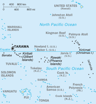
| map | Oceania |
| map_caption | Location of Jarvis Island in the Pacific Ocean |
| location | South Pacific Ocean |
| coordinates | |
| etymology | Edward, Thomas and William Jarvis |
| archipelago | Line Islands |
| area_km2 | 4.5 |
| length_km | 3.26 |
| width_km | 2.22 |
| coastline_km | 8.54 |
| elevation_m | 7 |
| country | United States |
| country_admin_divisions_title | Status |
| country_admin_divisions | unincorporated |
| population | 0 |
| timezone1 | Samoa Time Zone |
| utc_offset1 | -11:00 |
| footnotes | {{Infobox protected area |
| alt_name | **Jarvis Island National Wildlife Refuge** |
| iucn_category | Ia |
| designated | 1974 |
| child | yes |
| website | }} |
Jarvis Island (; formerly known as Bunker Island or Bunker's Shoal) is an uninhabited 4.5 km2 coral island located in the South Pacific Ocean, about halfway between Hawaii and the Cook Islands. It is an unincorporated, unorganized territory of the United States, administered by the United States Fish and Wildlife Service of the United States Department of the Interior as part of the National Wildlife Refuge system. Unlike most coral atolls, the lagoon on Jarvis is wholly dry.
Jarvis is one of the Line Islands and, for statistical purposes, is also grouped as one of the United States Minor Outlying Islands. Jarvis Island is the largest of three U.S. equatorial possessions, which include Baker Island and Howland Island.
The United States claimed it in the 19th century and mined it for guano. In the 20th century, it was the subject of a small settlement. It was attacked during World War II and evacuated, leaving some buildings and a day beacon. In modern times, it is managed as a nature reserve.
Geography and ecology
While a few offshore anchorage spots are marked on maps, Jarvis Island has no ports or harbors, and swift currents are a hazard. There is a boat landing area in the middle of the western shoreline near a crumbling day beacon and another near the island's southwest corner. The center of Jarvis island is a dried lagoon where deep guano deposits accumulated, which were mined for about 20 years during the nineteenth century. The island has a tropical desert climate, with high daytime temperatures, constant wind, and intense sun. Nights, however, are quite cool. The ground is mostly sandy and reaches 23 ft at its highest point. The low-lying coral island has long been noted as hard to sight from small ships and is surrounded by a narrow fringing reef.
Jarvis Island is one of two United States territories that are in the Southern Hemisphere (the other is American Samoa). Located only 25 mi south of the equator, Jarvis has no known natural freshwater lens and scant rainfall. This creates a very bleak, flat landscape without any plants larger than shrubs. There is no evidence that the island has ever supported a self-sustaining human population. Its sparse bunch grass, prostrate vines, and low-growing shrubs are primarily a nesting, roosting, and foraging habitat for seabirds, shorebirds, and marine wildlife.
Jarvis Island was submerged during the latest interglacial period, roughly 125,000 years ago, when sea levels were 5 to higher than today. As the sea level declined, the horseshoe-shaped lagoon formed in Jarvis Island's center.
Topographic isolation
Jarvis Island's highest point has a topographic isolation of 380.57 km, with Joe's Hill on Kiritimati being the nearest higher neighbor.
Time zone
Jarvis Island is located in the Samoa Time Zone (UTC -11:00), the same time zone as American Samoa, Kingman Reef, Midway Atoll, and Palmyra Atoll.
Birds
Jarvis Island once held some of the largest seabird breeding colonies in the tropical ocean. Still, guano mining and the introduction of rodents have ruined much of the island's native wildlife. Eight breeding species were recorded in 1982, compared to thirteen in 1996 and fourteen in 2004. The Polynesian storm petrel had made its return after over 40 years of absence from Jarvis Island, and the number of brown noddies multiplied from just a few birds in 1982 to nearly 10,000. Just twelve spectacled terns were recorded in 1982, but by 2004, over 200 nests were found there. The island, with its surrounding marine waters, has been recognized as an Important Bird Area (IBA) by BirdLife International because it supports colonies of lesser frigatebirds, brown and masked boobies, red-tailed tropicbirds, Polynesian storm petrels, blue noddies and sooty terns, as well as serving as a migratory stopover for bristle-thighed curlews.
History
Prehistory
Jarvis Island is unlikely to have hosted permanent human occupation before its use for guano mining. However, it is possible the island was utilized as a waypoint or stopover island by Polynesian voyagers. The remoteness of the island and a lack of freshwater resources have prevented large-scale archaeological surveys from taking place.
Discovery
The island's first known sighting by the British on August 21, 1821, by the British ship Eliza Francis (or Eliza Frances) owned by Edward, Thomas and William Jarvis and commanded by Captain Brown. The island was visited by whaling vessels until the 1870s.
The U.S. Exploring Expedition surveyed the island in 1841. In March 1857 the island was claimed for the United States under the Guano Islands Act and formally annexed on February 27, 1858.
Nineteenth-century guano mining
The American Guano Company, incorporated in 1857, established claims regarding Baker Island and Jarvis Island, recognized under the U.S. Guano Islands Act of 1856. Beginning in 1858, several support structures were built on Jarvis Island, along with a two-story, eight-room "superintendent's house" featuring an observation cupola and wide verandahs. Tram tracks were laid down to bring mined guano to the western shore. One of the first loads was taken by Samuel Gardner Wilder. Laborers for the mining operations came from around the Pacific, including from Hawaii; the Hawaiian laborers named Baker Island "Paukeaho", meaning 'out of breath' or 'exhausted', which is indicative of the hard work needed.
For the following 21 years, Jarvis was commercially mined for guano sent to the United States as fertilizer. The island was abruptly abandoned in 1879, leaving behind about a dozen buildings and 8,000 t of mined guano.
New Zealand entrepreneurs, including photographer Henry Winkelmann, then made unsuccessful attempts to continue guano extraction on Jarvis, and the two-story house was sporadically inhabited during the early 1880s. Squire Flockton was left alone on the island as caretaker for several months and committed suicide there in 1883, apparently from gin-fueled despair. His wooden grave marker was a carved plank which could be seen in the island's tiny four-grave cemetery for decades.
John T. Arundel & Co. resumed mining guano from 1886 to 1899. The United Kingdom annexed the island on June 3, 1889. Phosphate and copra entrepreneur John T. Arundel visited the island in 1909 on the maiden voyage of the S.S. Ocean Queen, and near the beach landing on the western shore, members of the crew built a pyramidal day beacon made from slats of wood, which was painted white. The beacon was standing in 1935, and remained until at least 1942.
Wreck of barquentine ''Amaranth''
.png)
On August 30, 1913, the barquentine Amaranth (C. W. Nielson, captain) was carrying a cargo of coal from Newcastle, New South Wales, to San Francisco when it wrecked on Jarvis' southern shore. Ruins of ten wooden guano-mining buildings, the two-story house among them, could still be seen by the Amaranth crew, who left Jarvis aboard two lifeboats. One reached Pago Pago, American Samoa, and the other made Apia in Samoa. The ship's scattered remains were noted and scavenged for many years, and rounded fragments of coal from the ''Amaranth'''s hold were still being found on the south beach in the late 1930s.
Millersville (1935–1942)
Main article: American Equatorial Islands Colonization Project
.jpg)
Jarvis Island was reclaimed by the United States government and colonized from March 26, 1935, onwards, under the American Equatorial Islands Colonization Project. President Franklin D. Roosevelt assigned administration of the island to the U.S. Department of the Interior on May 13, 1936. Starting as a cluster of large, open tents pitched next to the still-standing white wooden day beacon, the Millersville settlement on the island's western shore was named after a bureaucrat with the United States Department of Air Commerce. The settlement grew into a group of shacks built mostly with wreckage from the Amaranth (lumber from which was also used by the young Hawaiian colonists to build surfboards), but later, stone and wood dwellings were built and equipped with refrigeration, radio equipment, and a weather station. A crude aircraft landing area was cleared on the island's northeast side, and a T-shaped marker intended to be seen from the air was made from gathered stones, but no airplane is known to have ever landed there. According to the 1940 U.S. census, Jarvis Island had a population of three people.
At the beginning of World War II, an Imperial Japanese Navy submarine surfaced off the west coast of the island. Believing that a U.S. Navy submarine had come to fetch them, the four young colonists rushed down the steep western beach in front of Millersville towards the shore. The submarine answered their waves with fire from its deck gun, but no one was hurt in the attack. On February 7, 1942, the USCGC Taney evacuated the colonists, then shelled and burned the dwellings. The roughly cleared landing area on the island's northeast end was later shelled by the Japanese, leaving crater holes.
International Geophysical Year
Jarvis was visited by scientists during the International Geophysical Year from July 1957 until November 1958. In January 1958, all scattered building ruins from the nineteenth-century guano diggings and the 1935–1942 colonization attempt were swept away without a trace by a severe storm that lasted several days and was witnessed by scientists. When the IGY research project ended, the island was abandoned again. By the early 1960s, a few sheds, a century of accumulated trash, the scientists' house from the late 1950s, and a solid, short lighthouse-like day beacon built two decades before were the only signs of human habitation on Jarvis.
National Wildlife Refuge

.jpg)
On June 27, 1974, Secretary of the Interior Rogers Morton created Jarvis Island National Wildlife Refuge, which was expanded in 2009 to add submerged lands within 12 nmi of the island. The refuge now includes 1273 acre of land and 428580 acre of water. Along with six other islands, the island was administered by the U.S. Fish and Wildlife Service as part of the Pacific Remote Islands National Wildlife Refuge Complex. In January 2009, that entity was upgraded to the Pacific Remote Islands Marine National Monument by President George W. Bush.
A feral cat population, descendants of cats likely brought by colonists in 1937, wrought disruption to the island's wildlife and vegetation. Including the complete removal of rats, but not the mice, which had been introduced to the island previously. These cats were removed through efforts which began in the mid-1960s and lasted until 1990 when they were completely eradicated. Since cats were removed, seabird numbers and diversity have increased. Among the seabirds that returned to Jarvis Island with gray-backed terns rebuilding quickly and petrels taking longer to reestablish themselves on the island.
Nineteenth-century tram track remains can be seen in the dried lagoon bed at the island's center, and the late 1930s-era lighthouse-shaped day beacon still stands on the western shore at the site of Millersville.
Public entry to anyone, including U.S. citizens, on Jarvis Island requires a special-use permit and is generally restricted to scientists and educators. The U.S. Fish and Wildlife Service and the United States Coast Guard periodically visit Jarvis.
Transportation
| mapframe-zoom = 1 There is no airport on the island, nor does the island contain any large terminal or port. A day beacon near the middle of the west coast is in poor condition and no longer painted. Some offshore anchorage is available.
Military
As a U.S. territory, the defense of Jarvis Island is the responsibility of the United States. The laws of the United States apply when applicable.
References
References
- (1897). "The structure and distribution of coral reefs". D. Appleton and Company.
- "Jarvis Island". DOI Office of Insular Affairs.
- Rauzon, Mark J. (2016). ''Isles of Amnesia: The History, Geography, and Restoration of America's Forgotten Pacific Islands''. University of Hawai'i Press, Latitude 20. Page 38. {{ISBN. 9780824846794.
- (2003). "Jarvis Island". [[CIA]].
- Pacific Remote Islands National Wildlife Refuge Complex, ''[https://www.fws.gov/pacific/planning/main/docs/HI-PI/HBJ/Jarvis%20Draft%20CCP.pdf Jarvis Island NWR Draft CCP EA]'', August 2007, retrieved November 25, 2010: "No information is available on the subsurface hydrology of Jarvis Island. However, its small size and prevailing arid rainfall conditions would not likely result in a drinkable groundwater lens formation. During staff visits to Jarvis, potable water is carried in containers to the island for short visits."
- "United States Pacific Island Wildlife Refuges".
- "Jarvis Island – Pacific Biodiversity Information Forum photographs".
- Rauzon, Mark J. (2016). ''Isles of Amnesia: The History, Geography, and Restoration of America's Forgotten Pacific Islands''. University of Hawai'i Press, Latitude 20. Page 48. {{ISBN. 9780824846794.
- "Jarvis High Point, U.S. Minor Pacific Islands".
- "Joes Hill, Kiribati".
- Rauzon, Mark J. (2016). ''Isles of Amnesia: The History, Geography, and Restoration of America's Forgotten Pacific Islands''. University of Hawai'i Press, Latitude 20. Pages 38 and 56. {{ISBN. 9780824846794.
- . (2021). ["Jarvis Island"](http://datazone.birdlife.org/site/factsheet/jarvis-island-iba-united-states-minor-outlying-islands-(to-usa)). *BirdLife International*.
- (24 September 2008). "Jarvis Island National Wildlife Refuge: Comprehensive Conservation Plan". U.S. Fish & Wildlife Service.
- "North Pacific Pilot page 282".
- "R. v. Higgins, Fuller, Anderson, Thomas, Belford and Walsh". legal proceeding.
- (1975). "The Great United States Exploring Expedition". University of California Press.
- (1941). "Sovereignty over Islands in the Pacific". American Journal of International Law.
- (November 7, 1997). "GAO/OGC-98-5 – U.S. Insular Areas: Application of the U.S. Constitution". U.S. Government Printing Office.
- (May 3, 1865). "The Guano Companies in Litigation—A Case of Interest to Stockholders". New York Times.
- O'Donnell, Dan. (1995-01-01). "The nineteenth century Pacific guano trade". The Bulletin of the Australian Institute for Maritime Archaeology.
- (1925). "The Story of Hawaii and Its Builders". [[Honolulu Star Bulletin]].
- (2018). "Early Cultural and Historical Seascape of the Pacific Remote Islands Marine National Monument: Archival and Literary Research Report". NOAA Fisheries Pacific Islands Fisheries Science Center.
- ''Auckland Star'', Volume XIX, Issue 3978, 28 April 1883. [https://paperspast.natlib.govt.nz/newspapers/AS18830428.2.12 p. 2.]
- Gregory T. Cushman. (25 March 2013). "Guano and the Opening of the Pacific World: A Global Ecological History". Cambridge University Press.
- Arundel, Sydney. (1909). "Kodak photographs, Jarvis Island". Steve Higley.
- (1935). "Ocean Island and Nauru; Their Story". Angus and Robertson, limited.
- (1985). "The Phosphateers". Melbourne University Press.
- Edwin H. Bryan, Jr.. (1974). "Panala'au Memoirs". Pacific Scientific Information Center – Bernice P. Bishop Museum, Honolulu, Hawaii.
- Bryan, E.H. [http://www.janeresture.com/jarvis/ "Jarvis Island"] {{Webarchive. link. (May 25, 2017 Retrieved: July 7, 2008.)
- Tengan, Ty P. Kawika. (2004). "Of colonization and Pono in Hawai'i". Peace Review.
- McConnell, D. R.. (2024-04-29). "Prospects for Marine Minerals in the US Pacific OCS and EEZ". OTC.
- Bryan, Edwin H., Jr. [http://www.jarvisisland.info/panalaau_memoirs.html#photos Panala'au Memoirs.] Retrieved: July 7, 2008. Contains several photos of the Millersville settlement and a diary of events in the colony.
- (1940). "Sixteenth Census of the United States: Population, Volume I, Number of Inhabitants, Hawaii (Table 4)".
- "History of Jarvis Island". "World War Two" section of article..
- The IGY station chief was Otto H Homung (d. 1958), who apparently died on the island and may have been buried there.
- White, Susan. (October 26, 2011). "Welcome to Jarvis Island National Wildlife Refuge". U.S. Fish and Wildlife Service.
- Bush, George W.. (January 6, 2009). "Establishment of the Pacific Remote Islands Marine National Monument: A Proclamation by the President of the United States of America". [[White House]].
- (2011). "The history of mammal eradications in Hawai'i and the United States associated islands of the Central Pacific". Proceedings of the International Conference on Island Invasives.
- Rauzon, Mark J.. (1985). "Feral cats on Jarvis Island: their effects and their eradication". Atoll Research Bulletin.
- (1986). "Foods of Feral Cats Felis catus on Jarvis and Howland Islands, Central Pacific Ocean". Biotropica.
- (2017). "Modest increases in densities of burrow-nesting petrels following the removal of cats (Felis catus) from Marion Island". Polar Biology.
- "Jarvis Island National Wildlife Refuge". U.S. Fish and Wildlife Service.
- (2011). "Island Invasives: Eradication and Management".
- {{Cite rowlett. umi
- "The World Factbook — Central Intelligence Agency".
This article was imported from Wikipedia and is available under the Creative Commons Attribution-ShareAlike 4.0 License. Content has been adapted to SurfDoc format. Original contributors can be found on the article history page.
Ask Mako anything about Jarvis Island — get instant answers, deeper analysis, and related topics.
Research with MakoFree with your Surf account
Create a free account to save articles, ask Mako questions, and organize your research.
Sign up freeThis content may have been generated or modified by AI. CloudSurf Software LLC is not responsible for the accuracy, completeness, or reliability of AI-generated content. Always verify important information from primary sources.
Report