From Surf Wiki (app.surf) — the open knowledge base
Jalalabad
City in Nangarhar Province, Afghanistan

City in Nangarhar Province, Afghanistan
| Field | Value |
|---|---|
| official_name | Jalalabad |
| native_name | |
| settlement_type | Provincial capital |
| image_skyline | {{Photomontage |
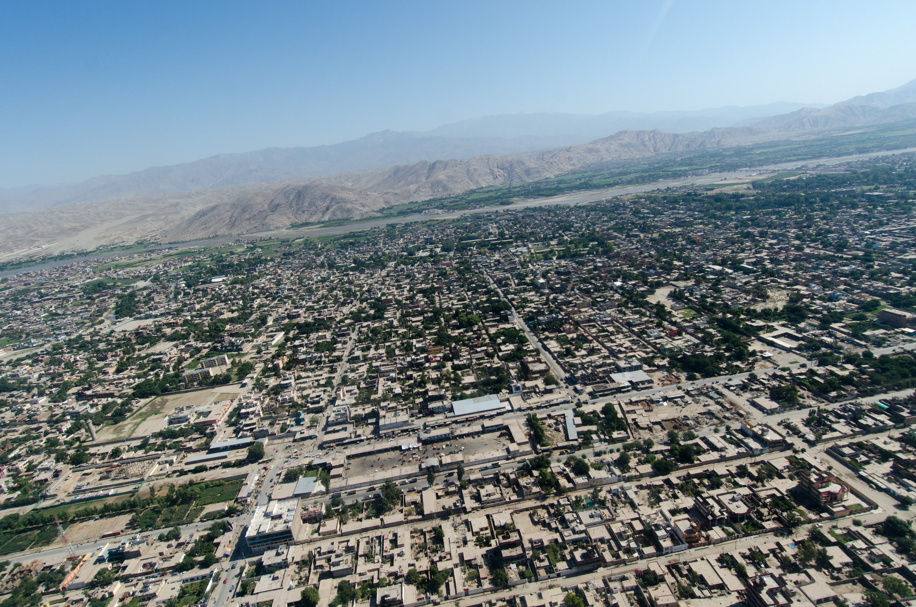
| photo1a | Aerial view of Jalalabad in 2012.jpg |
| photo2a | Irrigation in the fields of Jalalagad, Afghanistan (5774070247).jpg |
| photo2b | Ghousejaa.jpg |
| photo3a | Jalalabad stadium in 2011.jpg |
| photo3b | Bridge in Jalalabad in 2011.jpg |
| photo4a | Jalalabad in January 2011.jpg |
| color | white |
| color_border | white |
| position | center |
| spacing | 2 |
| size | 280 |
| image_caption | From top counter-clockwise: An aerial view of a section of Jalalabad, Irrigation fields in Jalalabad, Jalalabad Cricket Stadium, Jalalabad in January 2011, Jalalabad Bridge, Governor's House in Jalalabad |
| pushpin_map | Afghanistan#Hindu-Kush |
| pushpin_label_position | right |
| pushpin_map_caption | Location in Afghanistan |
| coordinates | |
| subdivision_type | Country |
| subdivision_name | Afghanistan |
| subdivision_type1 | Province |
| subdivision_name1 | Nangarhar |
| subdivision_type2 | District |
| subdivision_name2 | Jalalabad |
| established_title | Founded |
| established_date | 1570 |
| government_footnotes | |
| government_type | Municipality |
| leader_title | Mayor |
| leader_name | Qari Bismellah Bilal |
| leader_title1 | Deputy Mayor |
| leader_name1 | Mohammad Ishaq Saeed |
| area_footnotes | |
| area_total_km2 | |
| area_land_km2 | 122 |
| elevation_footnotes | |
| elevation_m | 575 |
| population_footnotes | |
| population_as_of | 2025 |
| population_total | 318733 |
| population_density_km2 | auto |
| population_urban | 318733 |
| timezone | Afghanistan Time |
| utc_offset | +04:30 |
| postal_code_type | |
| iso_code | AF-JAA |
| blank_name | Climate |
| blank_info | BWh |
| website |
Jalalabad, previously known as Tarunshahr, and historically known as Nagarahara or Adinapur, is a city in eastern Afghanistan, serving as the capital of Nangarhar Province. It has an estimated population of 318,733 people. Qari Bismellah Bilal is the current mayor of the city. Mohammad Ishaq Saeed serves as the current deputy mayor.
Jalalabad is home to Nangarhar University, which is in the northwestern area of the city. The Jalalabad Airport is in the southeastern part of the city. Jalalabad has a number of industrial parks, bazaars, business centers, public parks, banks, hotels, restaurants, mosques, hospitals, universities, and places to play sports or just relax. The city is connected by a road network with Asadabad to the northeast, Torkham to the southeast, and Kabul to the west. It is about 80 mi from the city of Kabul.
Jalalabad is located at the junction of the Kabul River and the Kunar River in a plateau to the south of the Hindu Kush mountains. It is a leading center of social and trade activity because of its proximity with the Torkham border checkpoint and border crossing, 65 km away. Major industries include poultry farming, processing agricultural products such as dried fruits, olives, dates, oranges and sugarcane, and producing household products and various types of snacks. For centuries the city was favored by Afghan kings and it has a cultural significance in Afghan poetry. During Timur Shah's reign of the Durrani Empire, Jalalabad served as the Afghan winter capital.
History
Ancient and medieval
Known at the time by names such as Nagarahara and Adinapur, Jalalabad was a major center of Greco-Buddhist culture during the late 1st millennium BCE, focused on sites such as Ahin Posh.
The first surviving references to the city are in early 1st millennium CE accounts by visiting Chinese Buddhist monks. In or about 400 CE, Faxian visited "Nagarahara" and worshiped at sacred Buddhist sites, such as the "Cave of the Buddha's Shadow” (佛影窟). In 630 CE, Xuan Zang, visited "Adinapur" and other locations nearby.
The Buddhist era began to end after the region was conquered by Muslim forces during the late 1st millennium. However, complete conversions to Islam evidently did not occur quickly. In Hudud-al-Alam, written in 982 CE, there is reference to a village near Jalalabad where a local ruler had Muslim, Buddhist and Hindu wives.
The region became part of the Muslim Ghaznavid Empire in the 10th century. Sabuktigin annexed the land all the way west of the Neelum River in Kashmir. "The Afghans and Khiljies who resided among the mountains having taken the oath of allegiance to Sabuktigin, many of them were enlisted in his army, after which he returned in triumph to Ghazni." The Ghurids succeeded the Ghaznavids and expanded the Islamic culture further into Hindustan. The region around Jalalabad later became part of the Khalji territory, followed by that of the Timurids.
Modern

It is said that the original name of Jalalabad was Adinapur or Nagar(a)hara. Jalalabad was named in the last decade of the sixteenth century in honor of Jalal-uddin Mohammad Akbar, ruler of the Mughal Empire at the time. His grandfather Babur had chosen the site for this city which was built by his grandson.
It remained part of the Mughal Empire until around 1738 when Nader Shah and his Afsharid forces defeated the Mughals. Nader Shah's forces were accompanied by the young Ahmad Shah Durrani and his 4,000-strong Afghan army from southern Afghanistan. In 1747, he founded the Durrani Empire (Afghan Empire) after re-conquering the area. The Afghan army has long used the city while going back and forth during their military campaigns into Hindustan.
In 1834, Dost Mohammad Khan subjugated Jalalabad in his campaign to Jalalabad. The British-Indian forces invaded Jalalabad in 1838, during the First Anglo-Afghan War. In the 1842 Battle of Jellalabad, Akbar Khan besieged the British troops on their way to Jalalabad. In 1878, during the Second Anglo-Afghan War, the British again invaded and set up camps in Jalalabad but withdrew two years later.
Jalalabad was besieged by rebel tribes in November 1928, marking the start of the Afghan Civil War of 1928-1929.
Jalalabad is considered one of the most important cities of the Pashtun culture. Seraj-ul-Emarat, the residence of Amir Habibullah and King Amanullah was destroyed in 1929 when Habibullah Kalakani rose to power; the other sanctuaries however, retain vestiges of the past. The mausoleum of both rulers is enclosed by a garden facing Seraj-ul-Emart. The Sulaimankhels, a Pashtun family famous for their scientific research, is from Jalalabad. Other celebrated Pashtun families originate from the villages near Jalalabad too.
By the early 1970s, construction had started on a new planned community within Jalalabad called Reg-e Shamshad Khan. From 1978 to early 1990s, the city served as a strategic location for the Soviet-backed Democratic Republic of Afghanistan and was temporarily renamed to Tarunshahr, in honour of Daoud Tarun. In March 1989, two mujahideen rebel factions backed by Pakistan and the United States assaulted the city during the Battle of Jalalabad. However, government forces managed to drive them out within two months, which was a major setback to the rebel fighters and Pakistan's ISI. The city was heavily bombarded and hundreds of civilians were killed. Many buildings, such as schools, hospitals and public buildings were destroyed during the 2-month battle.
On April 19, 1992, after then-President Najibullah resigned, Jalalabad fell to mujahideen rebel forces under Yunus Khalis. On September 12, 1996, the Taliban took control of the city until they were toppled by the US-backed Afghan forces in late 2001, which resulted in the Afghan Interim Administration under Hamid Karzai taking control. According to the United States, al-Qaeda had been building military training camps in the area.
In March 2007, US marines murdered 19 unarmed civilians and wounded 50 near Jalalabad, in an incident compared by the New York Times to the Haditha massacre. None of those responsible received any serious punishment. The Jalalabad Airport has long served as a military base for the NATO forces. Many suicide attacks by jihadist insurgents have taken place, including in August 2013, April 2015, January 2018, July 2018, September 2018, October 2019 and August 2020. The groups responsible for the attacks include the Taliban, Haqqani Network, al-Qaeda, and ISIS (Daesh). On August 15, 2021, the Taliban took control of Kabul and Jalalabad.
Geography
Jalalabad is a strategic city in eastern Afghanistan. It connects by a road network with Asadabad to the northeast, Torkham to the southeast, and Kabul to the west. It is at an elevation of 575 m above sea level, next to where the Kunar River merges into the Kabul River. The city is administratively divided into 6 city districts (nahias), covering a land area of 122 km2 or 12796 ha.
Agriculture is the predominant land use at 44%, higher density of dwellings is found in Districts 1–5 and vacant plots are largely clustered in District 6. Districts 1–6 all have a grid network of roads.
Flora and fauna
Jalalabad is home to a large number of fruit. Various types of citrus fruits like orange, tangerine, grapefruit, lemon, lime grow in gardens as well as in orchards. The narindj variety of orange is the most common one which has yellow skin and its taste is a combination of orange and grapefruit. The grapefruits grown here have a diameter of eight or nine inches. Per year 1800 tonnes of pomegranates, 334 tonnes of grapes, and 7750 tonnes of mulberries are produced in Jalalabad. The fruits are sold in local markets and transported to Kabul markets from where they are exported. The second most common crop is local vatani variety of sugarcane. It contains 15% sugar by weight. Jalalabad also has one of the largest date farms in Afghanistan.
Climate
Jalalabad's climate is hot desert (Köppen: BWh), and it is one of the hottest localities in Afghanistan. The city's climate has close resemblance to that of Arizona in the United States. It receives six to eight inches (152 to 203 mm) of rainfall per annum which are limited to winter and the months of spring. Frosts are not common, and during the summer, the temperature can reach a maximum of 120 °F (49 °C).
The north and southwestern parts of the city which has lower elevation are welcoming places to winds from the north and west cooling the parts in summer months. Jalalabad has the highest relative humidity in summer compared to other Afghan cities. However, the moderate temperatures of winter has led to various people down the history establishing their settlements in the city. Because of its warm temperature relative to most of Afghanistan, Jalalabad (alongside Peshawar) was often the "winter capital" of various Afghan rulers of the past centuries, while rich people would relocate to villas in Jalalabad to avoid the freezing temperatures in Kabul.
|Jan record high C = 25.0 |Feb record high C = 28.8 |Mar record high C = 34.5 |Apr record high C = 40.5 |May record high C = 45.4 |Jun record high C = 47.5 |Jul record high C = 44.7 |Aug record high C = 42.4 |Sep record high C = 41.2 |Oct record high C = 38.2 |Nov record high C = 32.4 |Dec record high C = 25.4 |Jan record low C = −14.1 |Feb record low C = -9.5 |Mar record low C = -1.0 |Apr record low C = 6.1 |May record low C = 10.6 |Jun record low C = 13.5 |Jul record low C = 19.0 |Aug record low C = 17.5 |Sep record low C = 11.0 |Oct record low C = 2.7 |Nov record low C = −4.5 |Dec record low C = −5.5 |access-date = December 25, 2012 |archive-date = May 8, 2024 |archive-url = https://web.archive.org/web/20240508114804/https://www.ncei.noaa.gov/pub/data/normals/WMO/1961-1990/RA-II/AH/40954.TXT |url-status = live
Demographics
Jalalabad has an estimated population of 318,733 people. In 2015 there were 39,586 dwelling units in the city.
Nearly all residents of Jalalabad are Muslim, followers of Sunni Islam. The city also has some Sikhs and Hindus, although the community has dwindled since the 1980s.
Economy
Jalalabad has a number of industrial parks. There are at least two steel mills in the city. Major industries in the city include poultry farming, processing agricultural products such as nuts and dried fruits, olive products, dates, oranges, sugarcane, and producing household products and various types of snacks.
Transportation
Jalalabad is connected by a road network with Asadabad to the northeast, Torkham to the southeast, and Kabul to west. The Kabul–Jalalabad Road is heavily used day and night, and still remains dangerous due to many accidents and the occasional rock falling from the high mountains. In January 2026 the city banned all auto rickshaw movements on the main roads in the city's center.
The Jalalabad Airport (also known as Nangarhar Airport) is located roughly 3 mi southeast from the city's center. It is a domestic airport for civilian use. It serves the population of the provinces of Nangarhar, Kunar and Nuristan.
There is a proposal for the establishment of a railway from Mazar-i-Sharif in Balkh Province to Jalalabad and then to Torkham in Momand Dara District.
Education
There are a number of public and private schools in Jalalabad. The following is a list of some of the universities in the city.
- Alfalah University
- Ariana University
- Khurasan University
- Nangarhar University
- Spinghar Higher Education Centre
Sports

Cricket, football, futsal and volleyball are the most popular sports in Afghanistan. Jalalabad is represented in domestic cricket competitions by the Nangarhar province cricket team. National team member Hamid Hasan was born in the province and he currently represents Afghanistan in international cricket. The Ghazi Amanullah International Cricket Stadium is the first international standard cricket stadium in Afghanistan. It is located in the Ghazi Amanullah Town, a modern suburb on the southeastern fringe of Jalalabad in Nangarhar Province. Construction on the stadium began in March 2010 when the foundation stone was laid by Omar Zakhilwal, the then-Minister of Finance and President of the Afghanistan Cricket Board. The project, which was developed on 30 acres of land donated by the developer constructing the Ghazi Amanullah Town, cost up the first phase of construction $1.8 million. The first phase, which took one year to complete, included the completion of the stadium itself. The remainder of the phases will see the construction of a pavilion, accommodation for players and administrative buildings. The stadium, which has a capacity of 14,000, was completed before the national team and under-19 team left for Canada and the Under-19 Cricket World Cup Qualifier in Ireland respectively. The two sides inaugurated the stadium in a Twenty20 match. It is hoped that the stadium will be able to attract international teams to play Afghanistan, who currently have One Day International status until at least 2013.
;Professional sports teams from Jalalabad
| Club | League | Sport | Venue | Established | Nangarhar Leopards | Speenghar Tigers | De Spin Ghar Bazan F.C. |
|---|---|---|---|---|---|---|---|
| Afghanistan Premier League | Cricket | Sharjah Cricket Stadium | 2018 | ||||
| Shpageeza Cricket League | Cricket | Ghazi Amanullah International Cricket Stadium | 2013 | ||||
| Afghan Premier League | Football | Nangarhar Football Stadium | 2012 |
;Stadiums
- Ghazi Amanullah International Cricket Stadium (around 15 mi southeast from Jalalabad, next to Ghazi Amanullah Town)
- Nangarhar Football Stadium (next to Abdul Haq Park and House of Governor)
- Behsud Cricket Stadium (next to Abdul Haq Park and House of Governor)
Places of interest
The Ghazi Amanullah International Cricket Stadium is next to the Ghazi Amanullah Khan Town, which is about 15 mi of driving distance southeast of Jalalabad. Some people of Jalalabad go there for sports purposes while others for leisure and enjoyment purposes. This is especially during holidays or when they receive visitors.

The following are some of the places of interest.
- Hotels
- Spinghar Hotel
- Sultan Hotel and Restaurant
- White House Hotel
- Mosques
- Akhunzada Mosque
- Spin Mosque
- Parks and Gardens
- Abdul Haq Park (located next to the city's main stadiums)
- Amir Habibullah Khan Park (across the street from Siraj-ul-Emarat Park)
- Aryan Park (located in the southwestern section of the city)
- Farm Hada Park (located in southern part of the city)
- Nakamura Park
- Siraj-ul-Emarat Park (located next to House of Governor)
- Mausoleums
- Mausoleum of King Amanullah Khan (Siraj-ul-Emarat Park)
- Mausoleum of Khan Abdul Ghaffar Khan
- Mausoleum of Mohammad Gul Khan Momand
- Hospitals
- Al Shifa Modern Hospital
- Bakhtar Hospital
- Baidara Hospital
- Hassanzai Curative Hospital
- Jalalabad Regional Hospital
- Jalalabad Medical Complex
- Khair-un-Nisa Medical Complex
- Spingha Momand Hospital
- Malalai Curative Hospital
- Nangarhar Teaching Hospital
- Naseri Hospital
- Rokhan Hospital
- Shopping centers
- Hejaz Super Market
- Jada Super Store
- Nakamura Super Store
International sister cities
- San Diego, California, United States
Notable people
- Rashid Khan, Afghan cricketer
- Abdul Baqi Haqqani, former Minister of Higher Education
- Hazrat Ali, politician and former military commander for the Northern Alliance
- Haji Abdul Qadeer, former Vice President of Afghanistan and Northern Alliance leader
- Abdul Haq, leader of a mujahideen faction
- Din Mohammad, former governor of Nangarhar and Kabul provinces
- Zahir Qadeer, former politician and member of the National Assembly
- Hamidullah Enayat Seraj, former civil servant
- Latif Nangarhari, poet and singer
- Ezatullah Zawab, journalist for Pajhwok Afghan News
- Baz Mohammad Abid, poet
- Amanullah Khan, Emir and King of Afghanistan (1919–1929), buried in the city
- Abdul Ghaffar Khan, buried in the city
- Mohammad Gul Khan Momand, buried in the city
- Tetsu Nakamura, died in the city
Notes
References
References
- "Massage from Jalalabad Municipality Mayor". Municipality of Jalalabad.
- (3 March 2025). "Balkh, Nangarhar Municipalities Sign Cooperation Agreement". TOLOnews.
- "Afghan poets dream of peace in Pashtun Jalalabad {{!}} Arts & Ent, Culture {{!}} THE DAILY STAR". The Daily Star.
- "Jalālābād".
- (1989-05-11). "Inside Jalalabad: A Sad, Crumbling Shel". The New York Times.
- Kuwayama, Shoshin. (2012). "India and Central Asia". Permanent Black.
- Vogelsang, Willem. (2002). "The Afghans". Wiley-Blackwell.
- "AMEER NASIR-OOD-DEEN SUBOOKTUGEEN". Packard Humanities Institute.
- "Afghanistan {{!}} Countries {{!}} Collection of Cooper Hewitt, Smithsonian Design Museum".
- Gazetteer of the Peshawar District 1897–98 Page 55
- (2011). "Historical Dictionaries of Asia, Oceania, and the Middle East : Historical Dictionary of Afghanistan". Scarecrow Press.
- Noelle, Christine. (1997). "State and Tribe in Nineteenth Century Afghanistan The Reign of Amir Dost Muhammad Khan (1826-1863)". Psychology Press.
- Ali, Mohammed. (1933). "Progressive Afghanistan". Punjab Educational Electric Press.
- (1932). "Summary of Events--Afghanistan. August 1919 to June 1932". General Staff, India.
- (6 July 2020). "Afghanistan, through a lifetime with Hashmat Ghani: Part 2".
- (1979-11-06). "(u) Current State of the Afghan Insurgency". Department of State.
- Rupert, James. (8 July 1989). "AFGHANISTAN REBELS LOSE KEY BATTLE". The Washington Post.
- "3Afghan".
- "Afghan rebels capture Jalalabad".
- [[Fintan O'Toole]], [https://www.nybooks.com/articles/2022/05/26/our-hypocrisy-on-war-crimes-fintan-otoole/ 'Our Hypocrisy on War Crimes,'] {{Webarchive. link. (2022-08-21 [[New York Review of Books]] 26 May 2022 pp. 10–13, p. 12.)
- (15 August 2021). "Nangarhar capital Jalalabad also collapses". Pajhwok Afghan News.
- (15 August 2021). "Taliban capture Afghanistan's Jalalabad, cut off Kabul from east". Al Jazeera.
- "State of Afghan Cities report 2015 (Volume-I English)". UN-Habitat.
- Michel, p.32
- Michel, p.33
- "Afghanistan – Drainage".
- Michel, p. 29
- Michel, p. 30
- Wright, Colin. "Jellalabad, the bastion where General Elphinstone and others were buried during the seige [sic] 1841–42.".
- Latifi, Ali M.. "Afghanistan halts independence festivities after wedding massacre".
- (September 2025). "Estimated Population of Afghanistan 2025-26". National Statistics and Information Authority.
- "State of Afghan Cities report 2015 (Volume-II)". UN-Habitat.
- (24 August 2025). "Afghan Hindus happy with security, seek lands’ restitution". Pajhwok Afghan News.
- (April 12, 2024). "India welcomes IEA's move to restore Hindus and Sikhs' properties as 'positive development'". Ariana News.
- "'When Are You Going Back?' Afghanistan's Sikhs, Strangers In Their Own Land".
- Kumar, Ruchi. "The decline of Afghanistan's Hindu and Sikh communities".
- Bearak, Barry. (2001-05-23). "Taliban Propose an Identity Label for the 'Protection' of Hindus (Published 2001)". The New York Times.
- {{YouTube. UwpLPnK4PKY. در این فارم در یک روز بیشتر از مصرف افغانستان تخم مرغ تولید می شود
- (30 October 2025). "Nangarhar Sees 45% Surge in Olive Harvest and Oil Production". TOLOnews.
- (5 August 2025). "Nangarhar Orchard Expects Over 20 Tons of Dates as Local Production Rises". TOLOnews.
- (1 December 2025). "Sweet orange yield to exceed 2200MT this year: MoAIL". Pajhwok Afghan News.
- (January 9, 2023). "Nangarhar produces 516 tons of peanuts in this solar year". Ariana News.
- (13 January 2026). "Rickshaws movement banned on key roads in Jalalabad City". Pajhwok Afghan News.
- (15 January 2026). "Rickshaw Movement Restricted in Jalalabad". TOLOnews.
- (June 18, 2022). "Civilian Flights Resume at Nangarhar Airport". TOLOnews.
- (15 January 2026). "Uzbekistan: Afghan-Trans Rail Feasibility Study Underway". TOLOnews.
- (14 January 2026). "Uzbekistan reaches key milestone in the Afghan–Trans Railway project". TOLOnews.
- "San Diego Jalalabad Sister Cities".
This article was imported from Wikipedia and is available under the Creative Commons Attribution-ShareAlike 4.0 License. Content has been adapted to SurfDoc format. Original contributors can be found on the article history page.
Ask Mako anything about Jalalabad — get instant answers, deeper analysis, and related topics.
Research with MakoFree with your Surf account
Create a free account to save articles, ask Mako questions, and organize your research.
Sign up freeThis content may have been generated or modified by AI. CloudSurf Software LLC is not responsible for the accuracy, completeness, or reliability of AI-generated content. Always verify important information from primary sources.
Report