From Surf Wiki (app.surf) — the open knowledge base
Islamabad Capital Territory
Federal territory of Pakistan
Federal territory of Pakistan
| Field | Value | |||
|---|---|---|---|---|
| <!--See the Table at Infobox settlement for all fields and descriptions of usage--> | official_name | Islamabad Capital Territory | ||
| native_name | ||||
| settlement_type | Federal territory | |||
| image_skyline | {{multiple image | |||
| total_width | 280px | perrow=1/2/2/2 | border=infobox | caption_align = center |
| image1 | Faisal Mosque and Margalla Hills.jpg | |||
| caption1 | Islamabad Expressway | |||
| image2 | Nekka Phullai beside Faisal maseet.JPG | |||
| caption2 | Margalla Hills | |||
| image3 | Nust.jpg | |||
| caption3 | Sector H-12 | |||
| image4 | G-13, Islamabad.jpg | |||
| caption4 | Sector G-13 | |||
| image5 | Long Exposure of Blue Area Islamabad.JPG | |||
| caption5 | Blue Area | |||
| image6 | King Faisal Mosque.jpg | |||
| caption6 | Cityscape of Islamabad | |||
| flag_size | 175px | |||
| shield_link | Mushtaq Ahmed | |||
| motto | ||||
| image_map | Islamabad Capital Territory in Pakistan (claims hatched).svg | |||
| map_caption | Location within Pakistan | |||
| coordinates | ||||
| subdivision_type | Country | |||
| subdivision_name | Pakistan | |||
| established_title | Established | |||
| established_date | ||||
| seat_type | Capital | |||
| seat | Islamabad | |||
| blank_name_sec1 | HDI (2022) | |||
| blank_info_sec1 | 0.854 | |||
| very high (1st) | ||||
| blank1_name_sec1 | Literacy rate (2023) | |||
| blank1_info_sec1 | 93.97% | |||
| blank2_name_sec1 | Seats in National Assembly | |||
| blank2_info_sec1 | 3 | |||
| blank_name_sec2 | Zones | |||
| blank_info_sec2 | 5 | |||
| blank3_name_sec2 | Sectors | |||
| blank3_info_sec2 | 81 | |||
| blank4_name_sec2 | Union Councils | |||
| blank4_info_sec2 | 50 | |||
| governing_body | ICT Administration | |||
| leader_title | Chief Commissioner | |||
| leader_name | Imran Khan (PAS) | |||
| leader_title1 | Deputy Commissioner | |||
| leader_name1 | Irfan Nawaz Memon | |||
| leader_title2 | Chairman CDA | |||
| leader_name2 | Amer Ali Ahmed | |||
| leader_title3 | High Court | |||
| leader_name3 | Islamabad High Court | |||
| area_footnotes | ||||
| area_total_km2 | 906.50 | |||
| area_land_km2 | ||||
| area_metro_km2 | ||||
| elevation_min_m | 490 | |||
| <!-- Population -----------------------> | population_total | 2,363,863 | ||
| population_as_of | 2023 | |||
| population_footnotes | ||||
| population_density_km2 | 2609.1 | |||
| population_density_sq_mi | auto | |||
| population_urban | 1108872 (46.91%) | |||
| population_density_urban_sq_mi | ||||
| population_rural | 1,254,991 | |||
| postal_code_type | Postcode | |||
| postal_code | 44000 | |||
| area_code | 051 | |||
| iso_code | PK-IS | |||
| blank5_name_sec1 | Main language(s) | |||
| blank5_info_sec1 | ||||
| blank6_name_sec1 | Notable sports teams | |||
| blank6_info_sec1 | Islamabad United, Islamabad Jinns | |||
| website | ||||
| elevation_max_m | 1500 | |||
| elevation_max_ft | 5000 | |||
| timezone | PKT | |||
| utc_offset | +05:00 | |||
| demographics_type1 | GDP | |||
| demographics1_title1 | Federal territory of Pakistan | |||
| demographics1_info1 | $12.8 billion (2024) | |||
| demographics1_title2 | Per capita | |||
| name | Islamabad Capital Territory | |||
| image_flag | Proposed Flag of Islamabad Capital Territory.svg | |||
| native_name_lang | ur | |||
| pushpin_map | Pakistan Islamabad Capital Territory |
a federal administrative unit of Pakistan
very high (1st)
The Islamabad Capital Territory is a federal territory of Pakistan, centred around Islamabad, the capital of Pakistan. It is located on the northern edge of the Pothohar Plateau, at the foot of the Margalla Hills, in the northwestern Punjab region. The Territory shares borders with the province of Khyber Pakhtunkhwa in the west and the province of Punjab in the remaining directions. It covers an area of 906.5 km2 and, according to 2023 census, has a population of over 2.3 million.
The area was separated from Rawalpindi District in 1967 to form a separate territory administered by the federal government. The territory is represented in the National Assembly by NA-52, NA-53, and NA-54 constituencies and by four seats in the Senate.
History
In 1960, land was transferred from the Rawalpindi District of Punjab province to replace the Karachi Federal Capital Territory and establish Pakistan's new capital. According to the 1960s master plan, the territory included much of what was Rawalpindi, and composed of the following parts:
- Rawalpindi, 259 km2
- Islamabad Urban, 220.15 km2
- Margalla Hills, 220.15 km2
- Islamabad Rural, 466.20 km2
However, Rawalpindi was eventually excluded from the Islamabad master plan in the 1980s.
Geography
The Islamabad Capital Territory is composed of eight types of areas: administrative, commercial, diplomatic, educational, green, industrial, residential, and rural.
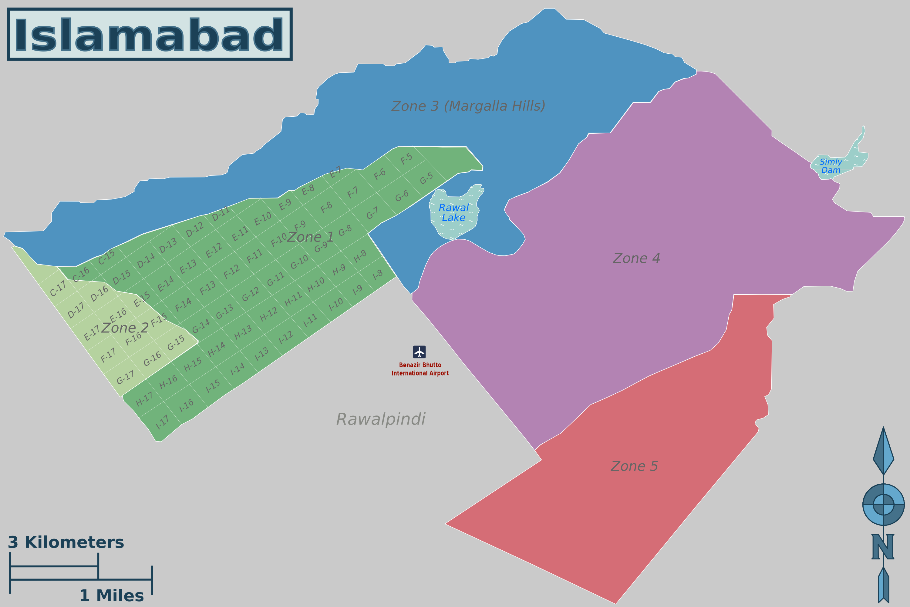
Zones

The territory is divided into five zones in two groups:
- Zone I: for urban development and federal government institutions
- Zone II: for urban development
- Zone III: for rural development
- Zone IV: for rural development
- Zone V: for rural development
Zone I consists mainly of all the developed residential sectors, while Zone II consists of the under-developed residential sectors. Each residential sector is identified by a letter of the alphabet and a number, and covers an area of approximately 4 square kilometres. The sectors are lettered from A to I, and each sector is divided into four numbered sub-sectors. Zone IV is the largest in area.
Sectors
Main article: Sectors of Islamabad
Series A, B, and C are still underdeveloped. The D series has seven sectors (D-11 to D-17), of which only sector D-12 is completely developed. This series is located at the foot of Margalla Hills. The E Sectors are named from E-7 to E-17. Many foreigners and diplomatic personnel are housed in these sectors. In the revised Master Plan of the city, CDA has decided to develop a park on the pattern of Fatima Jinnah Park in sector E-14. Sectors E-8 and E-9 contain the campuses of Bahria University, Air University, and the National Defence University. The F and G series contains the most developed sectors. F series contains sectors F-5 to F-17; some sectors are still under-developed. F-5 is an important sector for the software industry in Islamabad, as the two software technology parks are located here. The entire F-9 sector is covered with Fatima Jinnah Park. The Centaurus complex will be one of the major landmarks of the F-8 sector. G sectors are numbered G-5 through G-17. Some important places include the Jinnah Convention Center and Serena Hotel in G-5, the Red Mosque in G-6, and the Pakistan Institute of Medical Sciences, the largest medical complex in the capital, located in G-8.
The H sectors are numbered H-8 through H-17. The H sectors are mostly dedicated to educational and health institutions. National University of Sciences and Technology covers a major portion of sector H-12. The I sectors are numbered from I-8 to I-18. With the exception of I-8, which is a well-developed residential area, these sectors are primarily part of the industrial zone. Currently two sub-sectors of I-9 and one sub-sector of I-10 are used as industrial areas. CDA is planning to set up Islamabad Railway Station in Sector I-18 and Industrial City in sector I-17. Zone III consists primarily of the Margalla Hills and Margalla Hills National Park. Rawal Lake is in this zone. Zone IV and V consist of Islamabad Park, and rural areas of the city. The Soan River flows into the city through Zone V.
Climate
Main article: Climate of Islamabad
Seasons
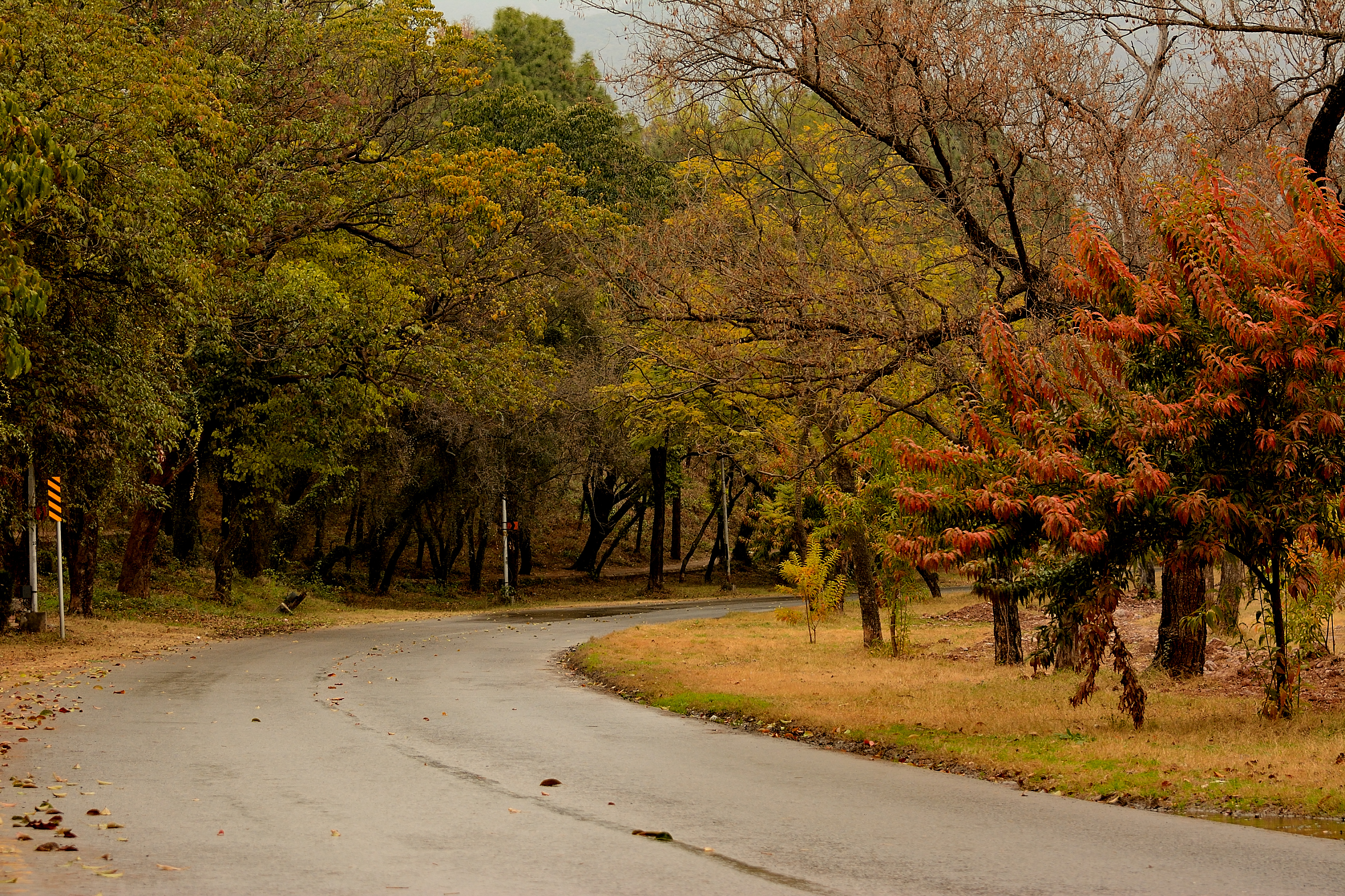
The climate of Islamabad has a humid subtropical climate (Köppen: Cwa), with five seasons: winter (November–February), spring (March and April), summer (May and June), rainy monsoon (July and August), and autumn (September and October).
Temperatures
The temperatures range from 13 C in January to 38 C in June. The hottest month is June, where average highs routinely exceed 38 C, while the coolest month is January. The highest recorded temperature was 46.6 C on 23 June 2005 while the lowest temperature was -6 C on 17 January 1967. Winters generally feature dense fog in the mornings and sunny afternoons. In the city, temperatures stay mild, with snowfall over the higher elevations points on nearby hill stations, notably Murree and Nathia Gali.
Precipitation
The wettest month is July, with heavy rainfalls and evening thunderstorms with the possibility of cloudburst and flooding. Highest monthly rainfall of 743.3 mm was recorded during July 1995. On 23 July 2001, Islamabad received a record breaking 620 mm of rainfall in just 10 hours. It was the heaviest rainfall in Islamabad in the past 100 years and the highest rainfall in 24 hours as well. The city has also experienced snowfall on a number of occasions. Islamabad's micro-climate is regulated by three artificial reservoirs: Rawal, Simli, and Khanpur Dam. The latter is located on the Haro River near the town of Khanpur, about 40 km from Islamabad. Simli Dam is 30 km north of Islamabad.
Vegetation
Around 220 acre of the city consists of the Margalla Hills National Park, while the Loi Bher Forest is situated along the Islamabad Highway, covering an area of 1087 acre.
Government
Main article: Government of the Islamabad Capital Territory
The government of the Islamabad Capital Territory is provided by the federal Government of Pakistan and by a number of territorial bodies. Article 258 of the Constitution of Pakistan stipulates that the President of Pakistan is responsible for establishing the government of the federal capital and the Parliament of Pakistan makes laws for the territory. Although the federal government retains strategic power over the territory, the day to day government is carried out by a number of bodies, which have been established over the years.
The Capital Development Authority (CDA), established on 14 June 1960, was responsible for building the capital and continues to have some government roles. The Islamabad Capital Territory Administration (ICTA) was established in 1980, and is led by a Chief Commissioner, who holds powers similar to a provincial government. The Islamabad High Court, established in 2007 (dissolved in 2008, re-established in 2010) is the senior court of the territory and is equivalent to the four provincial high courts. The Islamabad Metropolitan Corporation (MCI), established in 2015, is the municipal authority and is equivalent to a district government, as the upper tier of the local government in the territory. The CDA has been gradually transferring many of its roles to the MCI.
At the most local level, there are 101 union councils, though this is due to increase to 125 councils.
Union councils
At the most local level, the Territory comprises 101 union councils, though this is due to increase to 125 Union councils.
| UC # | Chief locality | Localities within jurisdiction |
|---|---|---|
| 1 | Saidpur | Said Pur, Gokina, Talhar |
| 2 | Noorpur Shahan | Noorpur Shahan, Ratta Hutar |
| 3 | Mal Pur | Mal Pur, Romali, Nariyas, Phadu, Shahdrah Khurd, Shahdrah Kalan, Mandala, Jang Begial, Subban Syedan, Mangial, Quaid-e-Azam University |
| 4 | Kot Hathial (Shamal) | Kot Hathial, Bhara Kahu, Nayiabadi, Muhallah Alnoor, Muhallah Ban, Muhallah Malkan, Dhok Syedan |
| 5 | Kot Hathial (Janoob) | Kot Hathial, Nainsukh, Barakahu, Behra Syedan, Muhallah Ghousia, Sharak-e-Madina, Dhok Jilani, Muhallah Malikabad |
| 6 | Phulgran | Phulgran, Phul Garan, Dhok Kuch, Abbasiabad, Dhok Badhan, Muhallah Kangar, Mahallah Ranjpuran, Shahpur, Bobry, Karlot Chattar, Mohra Rajpoota, Muhallah Sumbul, Bani Gala |
| 7 | Pind Begwal | Pind Begwal, Bainala, Maira Biguwal, Atthal, Dhok Sajjal, Dhok Nanda Sihali, Jandala, Simli |
| 8 | Tumair | Tumair, Pihont, Chakhtan, Darkalam, Kanjnah |
| 9 | Charah | Charah, Dhok Maira, Dhok Las, Kiani, Dhok Haveli |
| 10 | Kirpa | Kirpa, Ladhiot Syedan, Pind Malikan, Dhok Ban, Bhimbar Tarar, Mahallah Haveli Rajgan, Mehfozabad, Chaniol, Muhallah Chaudrian, Ara, Gora Mast, Dhok Jogian Harnu, Chauntra Sogran |
| 11 | Mughal | Mughal, Hardoghar, Kangota Gujjran Sihala, Hondamial, Nara Syedan, Chuchkal Chakiyan, Chak Kamdar |
| 12 | Rawat | Rawat, Bhangrial Kalan, Banni Saran, Mohra Nagial, Sawan, Bagga Shaikhan |
| 13 | Humak | Humak, Kaniyal, Gora Syedan, Niazian |
| 14 | Sihala | Sihala Khurd, Maira Dakhli, Bhandar Sihala, Jarki Sihala, Gagri Sihala, Jhundla, Kangota Syedan, Gura Mistriyan |
| 15 | Lohi Bhair | Lohi Bhar, Shahrak-e-Korang, Bagh-e-Sawan, Shahrak-e-Pakistan |
| 16 | Darwala | Darwala, Dhaliala, Panwal, Chucha Sheikhiyan, Bhair, Kanghar, Sher Ghamial, Dhok Kavgar, Kathrial, Chucha, Dhok Kashimiriya, Harn maira, Malali, Bun koutha, Pahg Panwal, Farash, Bangiyal |
| 17 | Koral | Koral, Tarlai Khurd, Gangal, Chaklala, Shareefabad, Gohra Sardar, Tarlai |
| 18 | Khana Dak | Khana Dak, Dhok Jabba, Pindorian, Shahrak-e-Bilal, Shahrak-e-Barma, Shahrak-e-Madina, Muhallah Wahid Abad, Shahrak-e-Masih) |
| 19 | Tarlai Kalan | Tarlai Kalan, Irfanabad, Chappar Meer Khanal, Sahana |
| 20 | Ali Pur | Ali Pur, Alipur, Jhang Syedan, Partal, Khadrapar, Farash, |
| 21 | Sohan | Sohan Dehati, Khana Kak, Shakrial, Shakrial (Sharki) |
| 22 | Chak Shahzad | Chak Shahzad, Chak Bihra Shigh, Jaba Teli, Sohana, Pandori, Chhatta Bakhtawar, Bohan, Dhoke Sharaf, Mujuhan |
| 23 | Kuri | Kuri, Malot, Rakh Bani Gala, Rihara, Mohra Jujan |
| 24 | Shahrak-e-Rawal | Shahrak-e-Rawal, Shahrak-e-Margala, Sumbal Korakh, Puna Faqeeran, Mohrian |
| 25 | Sector F-6 | F-6/1, F-6/2, F-6/3, F-6/4, Farooqi Bazar, Madni Masjid, Dhobi Gat |
| 26 | Sector G-6/1 | |
| 27 | Sector G-6 | Sector G-6/2, Sector G-6/3 & Sector G-6/4 |
| 28 | Sector F-7, F-8, F-9 | |
| 29 | Sector F-10, F-11 | |
| 30 | Sector G-7/3, G-7/4 | |
| 31 | Sector G-7/1, G-7/2 | |
| 32 | Sector G-8/3, G-8/4 | |
| 33 | Sector G-8/1, G-8/2 | |
| 34 | Sector G-9 | Sector G-9/1, G-9/3, G-9/4 |
| 35 | Sector G-9/2 | |
| 36 | Sector G-10/3, G-10/4 | |
| 37 | Sector G-10/1, G-10/2 | |
| 38 | Sector G-11 | Sector G-11/1, G-11/2, G-11/3, G-11/4 |
| 39 | Maira Sumbal Jaffar | Maira Sumbal Jaffar, Golra Sharif, Badia Rusmat Khan, Maira Akku, Dhareek Mohri, Shahrak-e-Effaq |
| 40 | G-13 | |
| 40 | Sector I-8 | Sector I-8/1, I8/2, I8/3, I8/4 |
| 41 | Sector I-9 | |
| 42 | Sector I-10/1 | |
| 43 | Sector I-10 | Sector I-10/2, I-10/3, I-10/4 |
| 44 | Bokra | Bokra, Haji Complex, Soria Harboza, Mouza Sorain, Peer Wadhai, Shahrak-e-Iqbal |
| 45 | Jhangi Saydan | |
| 46 | Village Noon | Badhana Kalan, Dhoke Makhan, ETC |
| 47 | Tarnol | |
| 48 | Sarai Kharbooza | |
| 49 | Shah Allah Ditta | |
| 50 | Golra Sharif |
Demographics
Population
According to the 2023 Census, Islamabad Capital Territory had a population of 2,363,863.
Language
According to 2023 Pakistani census, there are 1,154,540 Punjabi, 415,838 Pashto, 358,922 Urdu, 140,780 Hindko, 51,920 Kashmiri, 46,270 Saraiki, 21,362 Sindhi, 10,315 Balti, 7,099 Shina, 5,016 Koshistani, 4,503 Balochi, 1,095 Mewati, 668 Brahvi, 182 Kalasha and 64,734 others, of total 2,283,244 speakers.
After Islamabad's establishment, people from all around Pakistan shifted here which led to a diverse demographics. Punjabis constitute the largest ethnolinguistic population in the territory, with many having settled here from Punjab province as well. Pothwari dialect, which has been regarded by many as the dialect of Punjabi, has historically been the indigenous language of the region; and Punjabi still continues to be the most-widely spoken first language in Islamabad, with Punjabi-speakers forming a majority of the population. Punjabi is spoken in the form of many dialects and varieties, including the Majhi, Dhani, Shahpuri, Jhangvi, and Doabi dialects.
Religion
Hindu population in Islamabad is very small as per census, around 900, but other sources estimates it to be around 3000. The territory also hosts the historic important and sacred Ram mandir.
Islamabad-Rawalpindi metropolitan area
Main article: Islamabad–Rawalpindi metropolitan area
When the master plan for Islamabad was drawn up in 1960, Islamabad and Rawalpindi, along with the adjoining areas, was to be integrated to form a large metropolitan area called Islamabad/Rawalpindi Metropolitan Area. The area would consist of the developing Islamabad, the old colonial cantonment city of Rawalpindi, and Margalla Hills National Park, including surrounding rural areas. However, Islamabad city is part of the Islamabad Capital Territory, while Rawalpindi is part of Rawalpindi District, which is part of province of Punjab.
File:Chaghi Monument.JPG|Chaghi Monument File:Pak Secretariat buildings,Islamabad by Usman Ghani.jpg|Pakistan Secretariat File:Crescent and Star Monument.jpg|Star and Crescent Monument near the start of Shakarparian File:Faisal Masjid From Damn e koh.jpg|Faisal Mosque File:Daman-E-Koh.jpg|Daman-e-Koh Park File:Glorious Sunset in Islamabad.jpg|Sunset over the Lake View Park File:Hassle Bassle Islamabad.jpg|View of Blue Area, the commercial hub of the city. File:CloseupofLalMasjid.png|The Lal Masjid in Islamabad
Economy
Main article: Economy of Islamabad
Islamabad is a net contributor to the Pakistani economy, as whilst having only 0.8% of the country's population, it contributes 1% to the country's GDP. Islamabad Stock Exchange, founded in 1989, is Pakistan's third largest stock exchange after Karachi Stock Exchange and Lahore Stock Exchange. The exchange has 118 members with 104 corporate bodies and 18 individual members. The average daily turnover of the stock exchange is over one million shares. As of 2012, Islamabad LTU (Large Tax Unit) was responsible for Rs 371 billion in tax revenue, which amounts to 20% of all the revenue collected by Federal Board of Revenue.
Islamabad has seen an expansion in information and communications technology with the addition two Software Technology Parks, which house numerous national and foreign technological and information technology companies. The tech parks are located in Evacuee Trust Complex and Awami Markaz. Awami Markaz houses 36 IT companies while Evacuee Trust house 29 companies. Call centres for foreign companies have been targeted as another significant area of growth, with the government making efforts to reduce taxes by as much as 10% to encourage foreign investments in the information technology sector. Most of Pakistan's state-owned companies like PIA, PTV, PTCL, OGDCL, and Zarai Taraqiati Bank Ltd. are based in Islamabad. Headquarters of all major telecommunication operators such as PTCL, Mobilink, Telenor, Ufone, and China Mobile are located in Islamabad. Being an expensive city, the prices of most of fruits, vegetable and poultry items increased in Islamabad during the year 2015-2020
Tourism
Main article: Tourism in Islamabad Capital Territory
Transport
Main article: Transport in Islamabad
Airport
Islamabad is connected to major destinations around the world through the Islamabad International Airport. The airport is the largest in Pakistan, handling 9 million passengers per annum. The airport was built at a cost of $400 million and opened on 3 May 2018, replacing the former Benazir Bhutto International Airport. It is the first greenfield airport in Pakistan with an area of 3600 acre.
Metrobus
The Rawalpindi-Islamabad Metrobus is a 24 km bus rapid transit system that serves the twin cities of Rawalpindi and Islamabad in Pakistan. It uses dedicated bus lanes for all of its route covering 24 bus stations.
Motorways
All major cities and towns are accessible through regular trains and bus services running mostly from the neighbouring city of Rawalpindi. Lahore, Yarik, Dera Ismail Khan and Peshawar are linked to Islamabad through a network of motorways, which has significantly reduced travelling times between these cities. M-2 Motorway is 367 km long and connect Islamabad and Lahore. M-1 Motorway connects Islamabad with Peshawar and is 155 km long. Islamabad is linked to Rawalpindi through the Faizabad Interchange, which has a daily traffic volume of about 48,000 vehicles. M-14 Motorway connects Islamabad to Dera Ismail Khan and Yarik. It is 285 km (177 mi) long.
Education
Islamabad has the highest literacy rate of Pakistan at 95%. Islamabad also has some of Pakistan's major universities, including Quaid-i-Azam University, the International Islamic University, and the National University of Sciences and Technology and Pakistan Institute of Engineering and Applied Sciences
Quaid-e-Azam University has several faculties. The institute is located in a semi-hilly area, east of the Secretariat buildings and near the base of Margalla Hills. This Post-Graduate institute is spread over 1,705 acre. The nucleus of the campus has been designed as an axial spine with a library as its center. Other universities include the following:
- Bahria University
- Air University
- Quaid-e-Azam University
- Allama Iqbal Open University (AIOU)
- Alkauthar Islamic University
- COMSATS Institute of Information Technology (CIIT)
- Capital University of Science & Technology (CUST)
- Federal Urdu University of Arts, Science & Technology (FUUAST)
- National University of Sciences and Technology (NUST)
- National Defense University, Islamabad (NDU)
- National University of Modern Languages (NUML)
- Institute of Space Technology
- International Islamic University
- Institute of Cost and Management Accountants of Pakistan (ICMAP)
- Institute of Chartered Accountants of Pakistan (ICAP)
- Pakistan Institute of Development Economics (PIDE)
- Pakistan Institute of Engineering and Applied Sciences (PIEAS)
- Shifa College of Medicine
- Foundation University Islamabad (FUI)
- National University of Computer & Emerging Sciences (FAST-NUCES)
- Riphah International University
- University of Lahore
- Center for Advanced Studies in Engineering
- Preston University Islamabad Campus
- Iqra University Islamabad Campus
- Shaheed Zulfiqar Ali Bhutto Institute of Science and Technology (ZABIST)
- Hamdard University Islamabad Campus
Sports
Islamabad United became the first ever team to win Pakistan Super League in 2016. And now the federal team Is participating in the Pakistan Cup. In 2025, Islamabad United has won 3 Pakistan Super Leagues and earned 3 titles They won PSL: 1, PSL: 3, PSL: 9 which solidifies their number 1 rank as the team with the most victories.
Notes
References
References
- McGarr, Paul. (2013). "The Cold War in South Asia: Britain, the United States and the Indian Subcontinent, 1945–1965". Cambridge University Press.
- "Facts & Statistics – Islamabad".
- (19 August 2023). "Major shuffle in top bureaucracy on ECP direction". Dawn (newspaper).
- "Board Members – CDA".
- "CDA Facts & Figures".
- link. "Announcement of Results of 7th Population and Housing Census-2023". (5 August 2023)
- link. Google Maps. Google
- (2013). "The Emerging Asian City: Concomitant Urbanities and Urbanisms". Routledge.
- "Federal Territory".
- "Capital Development Authority".
- Matthew S. Hull. (5 June 2012). "Government of Paper: The Materiality of Bureaucracy in Urban Pakistan". University of California Press.
- "The Idea of Islamabad". TheIslamabad.com.
- Bahria University. "Official website".
- Air University. "Official website".
- National Defence University. "Official website".
- (13 June 2010). "Best Housing Societies in Islamabad to Invest in 2022".
- "Average Conditions, Islamabad, Pakistan".
- "Climate Records: Islamabad".
- "Severe Storms on dated 23rd July 2001 Islamabad, Pakistan". Abdul Hameed, Director Pakistan Meteorological Department.
- (6 August 2001). "Weather Log – July 21–31, 2001". National Climatic Data Center.
- "Urban growth monitoring along Islamabad Highway". GIS Development.
- . (28 February 2012). ["The Constitution of the Islamic Republic of Pakistan"](https://na.gov.pk/uploads/documents/1333523681_951.pdf). *[[National Assembly of Pakistan]]*.
- . (31 December 2022). ["N.A. Bill 70 of 2022"](http://pcp.gov.pk/SiteImage/Downloads/14101(22)Ex.Gaz%20III%20(NA).pdf). *Press Corporation of Pakistan*.
- "Population by administrative units 1951-1998". [[Pakistan Bureau of Statistics]].
- "Islamabad (District, Pakistan) - Population Statistics, Charts, Map and Location".
- "TABLE 11 – POPULATION BY MOTHER TONGUE, SEX AND RURAL/ URBAN". Pakistan Bureau of Statistics.
- "Population by Religion".
- Ali, Kalbe. (2020-09-20). "Temple in Islamabad is our requirement, says Hindu Council".
- Yasin, Aamir. (2016-10-09). "'Tourists, restaurants violate sanctity of Saidpur's temple'".
- (2025-05-08). "Interior Design".
- Dulyapak Preecharushh. (6 April 2011). "Engineering Earth: The Impacts of Megaengineering Projects". Springer.
- Muhammad. "Planning of Islamabad and Rawalpindi".
- Sheikh, Iqbal M.. "Environmental Geology of the Islamabad-Rawalpindi Area, Northern Pakistan". U.S. Department of the Interior, U.S. Geological Survey.
- (5 January 2010). "Pakistan | Economics and extremism". Dawn.
- "Pakistan Stock Exchanges".
- ISE-Official website. "About ISE".
- (5 July 2012). "Rs 371bn revenue target: FBR hails LTU Islamabad's performance". Business Recorder.
- Pakistan Software Export Board. "Islamabad".
- "Retail Prices of Vegetables, Fruits and Poultry in Islamabad from 2015-2020".
- CPG Corporation. "New Islamabad International Airport's Passenger Terminal Building".
- National Highway Authority Pakistan. "Motorway's of Pakistan".
- NESPAK. "Faizabad Interchange".
- "LITERACY-POPULATION 10 YEARS AND OLDER".
- [http://www.hec.gov.pk/ourinstitutes/pages/default.aspx HEC recognized Universities] {{webarchive. link. (29 October 2013 . Hec.gov.pk. Retrieved on 12 July 2013.)
- (24 February 2016). "ARY Digital Network President Salman Iqbal congratulates Islamabad United over winning PSL". arynews.tv.
This article was imported from Wikipedia and is available under the Creative Commons Attribution-ShareAlike 4.0 License. Content has been adapted to SurfDoc format. Original contributors can be found on the article history page.
Ask Mako anything about Islamabad Capital Territory — get instant answers, deeper analysis, and related topics.
Research with MakoFree with your Surf account
Create a free account to save articles, ask Mako questions, and organize your research.
Sign up freeThis content may have been generated or modified by AI. CloudSurf Software LLC is not responsible for the accuracy, completeness, or reliability of AI-generated content. Always verify important information from primary sources.
Report