From Surf Wiki (app.surf) — the open knowledge base
Hunza Valley
Valley in Pakistan administered Gilgit-Baltistan disputed Kashmir region

Valley in Pakistan administered Gilgit-Baltistan disputed Kashmir region
| Field | Value |
|---|---|
| name | Hunza Valley |
| native_name | bsk |
| photo | File:Rakaposhi, Nagar GB (Pakistan).jpg |
| photo_caption | The 7788 m tall Rakaposhi mountain towers over Hunza Valley |
| map | Gilgit Baltistan#Pakistan |
| country | Administered by Pakistan in the disputed Kashmir region |
| region | Gilgit-Baltistan |
| district | Hunza |
| coordinates | |
| coordinates_ref | |
| area_km2 | 11,660 |
| river | Hunza |
The Hunza Valley (; ) is a mountainous valley located in the region of Gilgit-Baltistan in Pakistan administered Kashmir.
Geography
The valley stretches along the Hunza River and shares borders with Ishkoman to the northwest, Shigar to the southeast, Afghanistan's Wakhan Corridor to the north, and China's Xinjiang region to the northeast. The valley floor sits at an elevation of 2,438 meters (7,999 feet). Geographically, the Hunza Valley is divided into three parts: Upper Hunza (Gojal), Central Hunza, and Lower Hunza (Shinaki).
History
Main article: State of Hunza
Buddhism and, to a lesser extent, Bön were the primary religions in the area. The region holds several surviving Buddhist archaeological sites, such as the Sacred Rock of Hunza. Hunza Valley was central in the network of trading routes connecting Central Asia to the subcontinent. It also provided protection to Buddhist missionaries and monks visiting the subcontinent, and the region played a significant role in the transmission of Buddhism throughout Asia.
Before the arrival of Islam, the majority of the population in the region practiced Buddhism. Since then, most of the population converted to Islam, predominantly following the Ismaili sect. The region contains numerous rock inscriptions in the ancient Brahmi script, created by Buddhist monks as expressions of worship and culture. With most locals converting to Islam, they had been mainly left ignored, destroyed, or forgotten, but are now being restored.
Hunza was formerly a princely state bordering Xinjiang (autonomous region of China) to the northeast and Pamir to the northwest, which survived until 1974, when it was finally dissolved by Zulfikar Ali Bhutto. The state bordered the Gilgit Agency to the south and the former princely state of Nagar to the east. The state capital was the town of Baltit (also known as Karimabad); another old settlement is Ganish Village which means 'Baba Ganesh village' (a Hindu name, Ganesh being name of a hindu deity). Hunza was an independent principality for more than 900 years and then in the early 1800s, Hunza played a vital role in the British "Great Game". In 1891 Hunza was captured by the British Empire, and the ruler of Hunza, Mir Safdar Ali Khan, fled to Kashgar, China, and the British army installed his brother Mir Nazim Khan (1892–1938) as a puppet ruler of Hunza Valley, but all orders were passed by British officers who were appointed in the capital Gilgit."
Mir of Hunza
Main article: Mir of Hunza
According to an account written by John Biddulph in his book Tribes of the Hindoo Koosh:
2010 landslide
On 4 January 2010, a landslide blocked the river and created Attabad Lake (also called Shishket Lake), resulting in 20 deaths and 8 injuries and effectively blocked about 26 km of the Karakoram Highway. The new lake extends 30 km and rose to a depth of 400 ft when it was formed as the Hunza River backed up. The landslide completely covered sections of the Karakoram Highway.
2018 rescue mission
On 1 July 2018, Pakistan Army pilots rescued 3 foreign mountaineers stuck in a snow avalanche above the height of 19000 ft on Ultar Sar Peak near Hunza. The weather conditions had made it difficult for the Army helicopter to go forth with a rescue operation on the 7388 m high Ultar Sar. Nonetheless, they completed it. Bruce Normand and Timothy Miller from the UK were successfully rescued alive while their companion Christian Huber from Austria had succumbed to the avalanche. Britain's High Commissioner Thomas Drew in Pakistan termed the mission "remarkable and dangerous".
Tourism
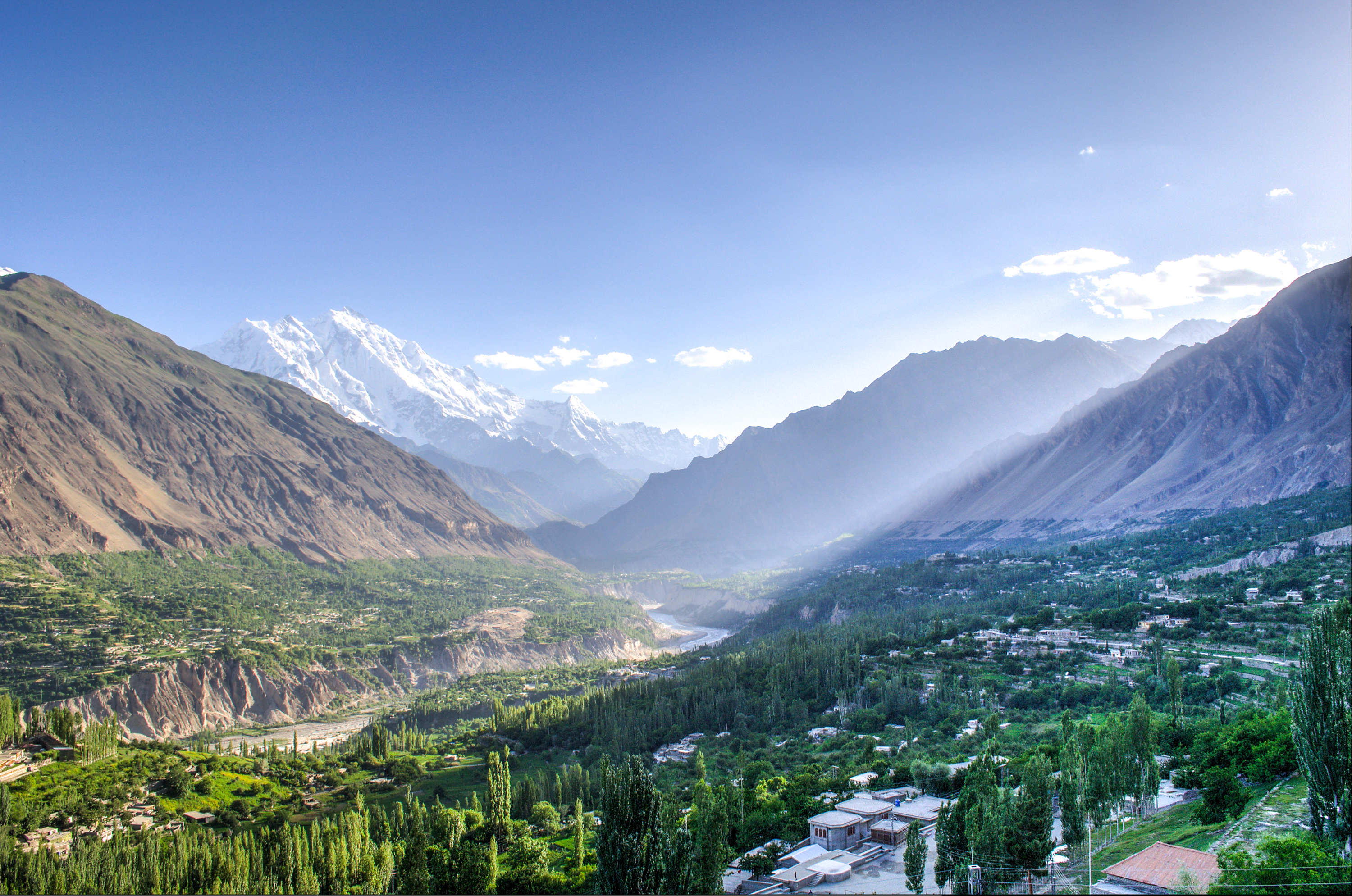

The Hunza Valley is home to several high peaks that rise above 7,000 m in its the surroundings. These include Rakaposhi, Distaghil Sar, Batura, Batura II, Batura III, Muchu Chhish, Kunyang Chhish, Shispare, Passu Sar, Kanjut Sar, Yukshin Gardan Sar, Pumari Chhish, and Momhil Sar.
The valley provides views of several mountains, including Ultar Sar 7,388 m (24,239 ft), Bojahagur Duanasir II 7,329 m (24,045 ft), Ghenta Peak 7,090 m (15,631 ft), Hunza Peak 6,270 m (20,571 ft), Darmyani Peak 6,090 m (19,980 ft), and Bublimating (Ladyfinger Peak) 6,000 m (19,685 ft).
Hunza Valley has a diverse religious history with it being home to several historic religious sites like the ancient watchtowers in Ganish village, Baltit Fort on top of karimabad which was built by the Mirs about 800 years ago , which is a historic landmark for hunza and Altit Fort (at the bottom of the valley).
Hunza also houses several lakes in its vicinity including Attabad Lake, Borith Lake, Shimshal Lakes, Hassanabad Lake. It is also home to the 57 km long Batura Glacier, the fifth-longest glacier in the world outside the polar region**,** is surrounded by Shispare, Batura, and Kumpirdior peaks.
The Khunjerab Pass, standing at a height of 4,693 meters (over 15,000 feet above sea level), is the highest paved international border crossing in the world. Strategically located on Pakistan's northern border and China's southwest border, it connects the two countries via Gilgit-Baltistan, making it a significant landmark of the Hunza Valley. Hiking treks include Ondra Poygah Gulmit and Leopard Trek Shiskhat.
The valley is popularly believed to be one of the inspiration for the mythical valley of Shangri-La in James Hilton's 1933 novel, Lost Horizon.
Demographics
Main article: Burusho people

The local languages spoken include Burushaski, Wakhi and Shina. The literacy rate of the Hunza valley is more than 95%. The establishment of community schools that provide high quality education, and the influence of the Aga Khan Mirs, contributing towards building universities for higher education have directed towards the high literacy rate in Hunza Valley, especially for girls. The historical area of Hunza and present northern Pakistan has had, over the centuries, mass migrations, conflicts and resettling of tribes and ethnicities, of which the Shina people are the most prominent in regional history. People of the region have recounted their historical traditions down the generations. The Hunza Valley is also home to some Wakhi, who migrated there from northeastern Afghanistan beginning in the nineteenth century onwards. The majority of residents in Hunza belong to the Ismaili Shia sect. They believe that Aga Khan V is their religious figurehead and transcendent. He is also believed to be the biggest promotor and contributor towards the literacy success and overall well-being of the people of Hunza and the valley itself.
The longevity of Hunza people has been noted by some, but others refute this as a longevity myth promoted by the lack of birth records. There is no evidence that Hunza life expectancy is significantly above the average of poor, isolated regions of Pakistan. Claims of health and long life were almost always based solely on the statements by the local mir (king). An author who had significant and sustained contact with Burusho people, John Clark, reported that they were overall unhealthy.
However, whether or not their putative longevity is true, it is undoubtable that the Hunza people lead a healthy lifestyle along with a healthy diet. Many researchers have lived with the Hunza people to answer this mystery including Robert McCarrison who did not discover a single person with diseases such as cancer, stomach ulcers or appendicitis. The research shows that high levels of exercise due the landscape and geography allows for them to be active and agile which factors in with their longevity , along with consumption of apricot seeds and oils, and the glacier water which contains minerals.
References
References
- "Rakaposhi Nagar on Google Maps".
- (2020). "Hunza matters: bordering and ordering between ancient and new Silk Roads". Harrassowitz Verlag.
- "Mountainous Valley situated in the northern part of India".
- (2011). "Capillary Routes of the Upper Indus". Brill.
- Behrendt, Kurt. (2003). "The Buddhist Architecture of Gandhāra". BRILL.
- (15 May 2012). "Highways, Byways, and Road Systems in the Pre-Modern World". John Wiley & Sons.
- Zara Khan, [https://pk.mashable.com/culture/3357/vandalized-buddhist-inscriptions-in-gilgit-baltistan-are-now-being-restored?amp=1 Vandalized Buddhist inscriptions in Gilgit-Baltistan are now being restored], Mashable Pakistan, 28 May 2020.
- (12 December 2011). "History of Hunza".
- "Hunza Valley".
- Tribes of the Hindoo Koosh by John Biddulph page 26
- (4 January 2013). "The Attabad Landslide Disaster". Pamir Times.
- Ahmed, Kamran. (23 May 2010). "Pakistan: The water bomb". Dawn.
- "Annual Report 2011". National Disaster Management Authority, Government of Pakistan.
- (27 July 2010}}{{dead link). "SHISHKET LAKE CRISES – 2010 – CHRONOLOGY OF EVENTS". [[National Disaster Management Authority (Pakistan).
- (May 2013). "Needed: a second green revolution in Hunza". HiMaT.
- (July 2018). "Pakistan Army Pilots rescued 3 foreign mountaineers".
- (July 2018). "Mountainers News on Thenews.com.pk".
- (July 2018). "Britain's High Commissioner in Pakistan admired Pak Army Pilots for rescued the two British Climbers". The Telegraph.
- (2 July 2018). "Major General Asif Ghafoor also tweeted about it".
- "Earth from Space: Batura Glacier".
- shahid, ariba. (October 20, 2023). "Khunjerab Pass linking Pakistan, China to stay open all year round".
- admin. (2021-07-12). "Amazing Views of Hunza Valley…".
- Craig, Tim. (2023-04-10). "High up on a Pakistani mountain, a success story for moderate Islam". Washington Post.
- Siddiqui, Shahid. "Hunza disaster and schools". [[Dawn (newspaper).
- Frembgen Wasim, Jurgen. (2017). "The Arts and Crafts of the Hunza Valley in Pakistan: Living traditions in the Karakoram". Oxford University Press.
- Wrench, Guy T., Dr.. (2009). "The Wheel of Health: A study of the Hunza people and the keys to health". Review Press.
- Tierney, John. (29 September 1996). "The optimists are right". The New York Times.
- Clark, John. "Hunza – the truth, myths, and lies about the health and diet of the "long-lived" people of Hunza, Pakistan – Hunza bread and pie recipes".
- (17 February 2024). "People in this remote valley live to 100—they follow 5 distinct diet and lifestyle habits for longevity". CNBC.
This article was imported from Wikipedia and is available under the Creative Commons Attribution-ShareAlike 4.0 License. Content has been adapted to SurfDoc format. Original contributors can be found on the article history page.
Ask Mako anything about Hunza Valley — get instant answers, deeper analysis, and related topics.
Research with MakoFree with your Surf account
Create a free account to save articles, ask Mako questions, and organize your research.
Sign up freeThis content may have been generated or modified by AI. CloudSurf Software LLC is not responsible for the accuracy, completeness, or reliability of AI-generated content. Always verify important information from primary sources.
Report