From Surf Wiki (app.surf) — the open knowledge base
Gulf of Mexico
Marginal sea of the Atlantic Ocean

Marginal sea of the Atlantic Ocean
| Field | Value |
|---|---|
| name | Gulf of Mexico |
| image_bathymetry | Gulf_of_Mexico_ETOPO_2022_(labeled).png |
| caption_bathymetry | Bathymetry of the Gulf of Mexico |
| location | American Mediterranean Sea |
| width | 1500 km |
| area | 1550000 km2 |
| depth | 1615 m |
| max-depth | 3750 to 4384 m |
| coords | |
| rivers | Rio Grande, Mississippi River, Mobile River, Panuco River, Jamapa River, Pascagoula River, Tecolutla River, Usumacinta River, Apalachicola River |
| oceans | Atlantic Ocean, Caribbean Sea |
| countries | |
| settlements | Veracruz, Houston, New Orleans, Corpus Christi, Tampa, Havana, Southwest Florida, Mobile, Gulfport, Matamoros, Brownsville, Tampico, Key West, Cabo Catoche / Cancún, Ciudad del Carmen, Coatzacoalcos, Panama City |
| other_name | *Golfo de México* |
| mapframe | yes |
| mapframe-zoom | 4 |
| mapframe-height | 275 |
| max-depth = 3750 to 4384 m | mapframe-zoom = 4 | mapframe-height = 275
The Gulf of Mexico () is an oceanic basin and a marginal sea of the Atlantic Ocean, mostly surrounded by the North American continent. It is bounded on the northeast, north, and northwest by the Gulf Coast of the United States; on the southwest and south by the Mexican states of Tamaulipas, Veracruz, Tabasco, Campeche, Yucatán, and Quintana Roo; and on the southeast by Cuba.
The Gulf of Mexico basin is roughly oval and is about 810 nmi wide. Its floor consists of sedimentary rocks and recent sediments. It is connected to part of the Atlantic Ocean through the Straits of Florida between the U.S. and Cuba, and with the Caribbean Sea via the Yucatán Channel between Mexico and Cuba. Because of its narrow connection to the Atlantic Ocean, the gulf has very small tidal ranges. Moisture from the Gulf of Mexico also contributes to weather across the United States, including severe weather in Tornado Alley.
The size of the gulf basin is about 1.6 e6km2. Almost half of the basin consists of shallow continental shelf waters. The volume of water in the basin is roughly 642e15 USgal (642e15 USgal). The gulf is one of the most important offshore petroleum production regions in the world, making up 14% of the total production for the United States.
Name

_-_The_fourth_book._Describing_The_West-India_navigation,_from_Hudson's_Bay_to_the_River_Amazones._Particularly_delineating_The_Sea_Coasts,_Capes,_Headlands,_(14780240045).jpg)
As with the name of Mexico, the gulf's name is associated with the ethnonym Mexica, which refers to the Nahuatl-speaking people of the Valley of Mexico better known as the Aztecs. In Aztec religion, the gulf was called Chalchiuhtlicueyecatl, or 'House of Chalchiuhtlicue', after the deity of the seas. Believing that the sea and sky merged beyond the horizon, they called the seas , meaning 'sky water', contrasting them with finite, landlocked bodies of water, such as lakes. The Maya civilization, which used the gulf as a major trade route, likely called the gulf nahá, meaning 'great water'.
Up to 1530, European maps depicted the gulf, though left it unlabeled. Hernán Cortés called it "Sea of the North" () in his dispatches, while other Spanish explorers called it the "Gulf of Florida" (Golfo de Florida) or "Gulf of Cortés" (Golfo de Cortés). A 1584 map by Abraham Ortelius also labeled it as the "Sea of the North" (Mare de Nort). Other early European maps called it the "Gulf of St. Michael" (), "Gulf of Yucatán" (Golfo de Iucatan), "Yucatán Sea" (Mare Iuchatanicum), "Great Antillean Gulf" (Sinus Magnus Antillarum), "Cathayan Sea" (Mare Cathaynum), or "Gulf of New Spain" (). At one point, New Spain encircled the gulf, with the Spanish Main extending into what later became Mexico and the southeastern United States.
The name "Gulf of Mexico" (; , later golfe du Mexique) first appeared on a world map in 1550 and a historical account in 1552. As with other large bodies of water, Europeans named the gulf after Mexico, land of the Mexica, because mariners needed to cross the gulf to reach that destination. This name has been the most common name since the mid-17th century, when it was still considered a Spanish sea. French Jesuits used this name as early as 1672. In the 18th century, Spanish admiralty charts similarly labeled the gulf as "Mexican Cove" or "Mexican Sound" (Ensenada Mexicana or Seno Mexicano). Until the Republic of Texas broke away from Mexico in 1836, Mexico's coastal boundary extended eastward along the gulf to present-day Louisiana.
Among the other languages of Mexico, the gulf is known as in Nahuatl, in Yucatec Maya, and in Tzotzil. Although there is no formal protocol on the general naming of international waters, Gulf of Mexico is officially recognized by the International Hydrographic Organization, which seeks to standardize the names of international maritime features for certain purposes and counts all three countries adjacent to the gulf as member states.
In a January 2025 executive order, United States president Donald Trump directed federal agencies to adopt the name "Gulf of America" for the waters bounded by the U.S. Some major online map platforms and several U.S.-based media outlets voluntarily adopted the change, but it also stoked controversy, with Mexican president Claudia Sheinbaum and others objecting to the declaration. A February 2025 poll by Marquette University found that, among 1,018 respondents across the U.S., 71% opposed renaming the Gulf of Mexico and 29% supported the name change.
Extent
The International Hydrographic Organization publication Limits of Oceans and Seas defines the southeast limit of the Gulf of Mexico as:
A line joining Cape Catoche Light () with the Light on Cape San Antonio in Cuba, through this island to the [meridian of 83°W](83rd-meridian-west) and to the Northward along this meridian to the latitude of the South point of the Dry Tortugas (24°35′N), along this parallel Eastward to Rebecca Shoal (82°35′W) thence through the shoals and Florida Keys to the mainland at the eastern end of Florida Bay and all the narrow waters between the Dry Tortugas and the mainland being considered to be within the Gulf.
Population
The Gulf Coast of the United States, or Gulf Coastal Region, is composed of parts of the five U.S. states facing the Gulf. In 2016, the total population of the region was 15.8 million people. Major cities along the coast include Houston, Texas; New Orleans, Louisiana; Mobile, Alabama; and Pensacola, Florida.
The six Mexican states that face the gulf have a total population of 19.1 million people.
Three provinces of northwest Cuba, including Havana, border on the gulf, have a combined population of 3,211,000.
Geology
The Gulf of Mexico took shape about 300 million years ago as a result of plate tectonics. The consensus among geologists is that before the late Triassic, the Gulf of Mexico did not exist. Before the late Triassic, the area consisted of dry land, which included continental crust that now underlies Yucatán, within the middle of the supercontinent Pangaea. This land lay south of a continuous mountain range that extended from north-central Mexico, through the Marathon Uplift in west Texas and the Ouachita Mountains of Oklahoma, and to Alabama where it linked directly to the Appalachian Mountains. It was created by the collision of continental plates that formed Pangaea. As interpreted by Roy Van Arsdale and Randel T. Cox, this mountain range was breached in the late Cretaceous by the formation of the Mississippi Embayment.

The rifting that created the basin was associated with zones of weakness within Pangaea, including sutures where the Laurentia, South American, and African plates collided to create it. Firstly, there was a late Triassic–early Jurassic phase of rifting during which rift valleys formed and filled with continental red beds. Secondly, the continental crust was stretched and thinned as rifting progressed through the early and middle Jurassic times. This thinning created a broad zone of transitional crust, which displays modest and uneven thinning with block faulting and a broad zone of uniformly thinned transitional crust, which is half the typical 40 km thickness of continental crust. At this time, rifting first created a connection to the Pacific Ocean across central Mexico and later eastwards to the Atlantic Ocean. This flooded the opening basin to create an enclosed marginal sea. The subsiding transitional crust was blanketed by the widespread deposition of Louann Salt and associated anhydrite evaporites. During the late Jurassic, continued rifting widened the basin and progressed to the point that seafloor spreading and formation of oceanic crust occurred. At this point, sufficient circulation with the Atlantic Ocean was established that the deposition of Louann Salt ceased. Seafloor spreading stopped at the end of the Jurassic, about 145–150 million years ago.
During the late Jurassic through early Cretaceous, the basin experienced a period of cooling and subsidence of the crust underlying it. The subsidence resulted from crustal stretching, cooling, and loading. Initially, the crustal stretching and cooling combination caused about 5 – of tectonic subsidence of the central thin transitional and oceanic crust. The basin expanded and deepened because subsidence occurred faster than sediment could fill it.
Later, loading of the crust within the basin and adjacent coastal plain by the accumulation of kilometers of sediments during the rest of the Mesozoic and all of the Cenozoic further depressed the underlying crust to its current position about 10 – below sea level. Particularly during the Cenozoic, a time of relative stability for the coastal zones, thick clastic wedges built out the continental shelf along the northwestern and northern margins of the basin.
To the east, the stable Florida Platform was not covered by the sea until the latest Jurassic or the beginning of Cretaceous time. The Yucatán Platform was emergent until the mid-Cretaceous. After both platforms were submerged, the formation of carbonates and evaporites has delineated the geologic history of these two stable areas. Most of the basin was rimmed during the early Cretaceous by carbonate platforms, and its western flank was involved during the latest Cretaceous and early Paleogene periods in a compressive deformation episode, the Laramide Orogeny, which created the Sierra Madre Oriental of eastern Mexico.
The Gulf of Mexico is 41% continental slope, 32% continental shelf, and 24% abyssal plain, with the greatest depth of 12,467 feet in the Sigsbee Deep.
Seven main areas are given as:
- Gulf of Mexico basin; contains the Sigsbee Deep.
- Northeast Gulf of Mexico; extends from a point east of the Mississippi River Delta near Biloxi to the eastern side of Apalachee Bay.
- South Florida Continental Shelf and Slope; extends along the coast from Apalachee Bay to the Straits of Florida and includes the Florida Keys and Dry Tortugas.
- Campeche Bank; extends from the Yucatán Straits in the east to the Tabasco–Campeche Basin in the west and includes Arrecife Alacran.
- Bay of Campeche; a bight extending from the western edge of Campeche Bank to the offshore regions east of Veracruz.
- Western Gulf of Mexico; located between Veracruz to the south and the Rio Grande to the north.
- Northwest Gulf of Mexico; extends from Alabama to the Rio Grande.
Brine pools
A number of brine pools, sometimes called brine lakes, are known on the seafloor of the northern half of the Gulf of Mexico. Brine pools in the Gulf of Mexico range from just 1 m across to 20 km long. Brine is produced wherever the water of the Gulf comes in contact with the Louann Salt, an evaporite formation from the Jurassic period, along faults or in unconsolidated sediments. The Louann Salt extends under most of the continental shelf around the northern part of the Gulf from west of Florida to Texas. Under the pressure of overlaying sediments, the salt deforms and migrates, a process known as salt tectonics. Masses of salt may rise through overlaying sediments to form salt domes, or may be extruded along the Sigsbee Escarpment where the slope of the continental shelf exposes lower laying stata.
The brines usually exceed 200 parts-per-thousand (ppt) of salt and are 25% or more denser than most seawater (average 35 ppt). The density difference inhibits mixing of the brine with other sea water, and the brine flows downslope and gathers in depressions in the gulf floor. Hydrocarbons and gas hydrates rising from salt diapirs may cause doming of the gulf floor, with the gas sometimes erupting strongly enough to leave a depression in the gulf floor surrounded by a rim, where brine may pool. The East Flower Garden Bank brine pool is in a crater formed by the collapsed cap of a salt dome. The circular pool covers 500 m2 with a maximum depth of 25 cm, and is 70 m beneath the surface of the Gulf. It is anoxic and contain quantities of hydrogen sulfide and methane.
The brine pool known as GB425, which is 600 m deep, is fed by a mud volcano. The temperature at the surface of the pool can vary from 6 to 48 °C, and is on average 20 °C warmer than normal bottom temperatures. The brine pool known as GC233 is at a depth similar to that of GB425, 650 m deep. The pool sits in a depression at the top of a mound and covers about 190 m2. Although GC233 has a lower inflow of brine than GB425 and a temperature about 15 °C below that of GB425, the two pools share some similarities, such as a salinity of about 130 ppt, low sulfides, almost no sulfates, and high concentrations of hydrocarbons.
The Orca Basin is 2100 m deep, and covers about 400 km2 with a maximum depth of 350 m. The large size is the result of the merger of several salt domes. Salinity in the pool increases gradually over a depth of 75 m, and reaches 300 ppt at depth, with zero dissolved oxygen.
A brine pool was discovered in 2014 on the sea floor at a depth of 3300 ft with a circumference of 100 ft and depth of 12 ft, which is four to five times saltier than the surrounding water. The site cannot sustain any kind of life other than bacteria, mussels with a symbiotic relationship, tube worms, and certain kinds of shrimp. It has been called the "Jacuzzi of Despair" because it is warmer at 65 F compared to the surrounding water at 39 F.
Hydrology
Circulation of water in and through the Gulf is part of the larger circulation patterns of the Atlantic Ocean. Water flows into the Gulf from the Caribbean Sea through the Yucatan Channel as the Yucatan Current, and exits to the North Atlanic Ocean through the Florida Straits as the Florida Current, which becomes the Gulf Stream. Movement through the two straits is confined to the upper layers of ocean water, as the Yucatan Strait has a maximum depth of only 1800 m, while the Florida Straits has a maximum depth of only 900 m.
The Yucatan Current fills most of the Yucatan Channel to a depth of up to 800 m, with a maximum flow of 120 cm per second. There are weaker countercurrents along the coasts of Cuba and Yucatan and below the main current. The average volumetric flow rate through the Yucatan Channel varied between 15.8 and 28.1 Sverdrups (hectometers per second) from 1999 to 2013. The Florida Current fills all of the Florida Straits (at approximately 81°W, between the lower Florida Keys and Cuba) to a depth of 800 m, with a maximum flow of 110 cm per second. The average volumetric flow rate through the Florida Straits varied between 27.2 and 27.9 Sverdrups.
The Yucatan Current is connected to the Florida Current by an anti-cyclonic (clockwise) loop of variable size, the Loop Current. The Loop Current may extend into the northeastern part of the Gulf, and may flow over the continental shelf along the west coast of the Florida peninsula. The Loop Current is as strong as the Gulf Stream and dominates the Gulf. Anti-cyclonic and cyclonic (anti-clockwise) rings or eddies are shed from the Loop Current and move into the western Gulf. Cyclonic and anti-cyclonic eddies form pairs, and such pairs of eddies often dominate circulation in the western Gulf.
The Loop Current is up to 300 km in diameter and is surrounded by small cyclonic (anti-clockwise) eddies. Large warm-core rings or eddies are shed off the Loop Current at irregular intervals. The Loop Current can be seen in satellite images using both sea surface temperatures and Sea surface height. On the east side of the Gulf, a weak countercurrent flows north along the continental slope of the Florida peninsula. In the Northeast corner of the Gulf there is a weak cyclonic circulation over the continental shelf. The strength of this circulation is inversely proportional to how far north the Loop Current extends.
The Loop Current is part of the North Atlantic Gyre, an ocean current circulation that includes the Gulf Stream, North Atlantic Current, Canary Current, and North Equatorial Current. The eddies shed by the Loop Current spread though the Gulf, affecting the circulation in almost all parts of the Gulf. The creation of the eddies is a variable and often complex process, influenced in part by how far the Loop Currents has penetrated into the Gulf. Eddies shed by the Loop Current sometimes reattach to the Loop Current. Eddies surrounding the Loop Current react interactively with it, affecting both the penetration of the loop into the Gulf, and the size and number of eddies shed by the loop.
Rings or eddies shed from the Loop Current may be up to 300 km in diameter and 800 to 1000 m deep. The outer currents in the ring may flow at up to 4 kn, while the rings as a whole move westward at about 0.20 kn.
The water flowing into the Gulf from the Caribbean Sea is not homogenous. About 40% is from the South Atlantic Ocean, and is warmer and fresher than the rest of the water. The South Atlantic component is distinguishable in the upper 100 m of the left hand and central parts of the Florida Current. Another component in the deeper part of the current is Antarctic Intermediate Water. The rest of the water carried into the Gulf consists of various masses from the North Atlantic.
History
Pre-Columbian
The earliest known humans to arrive on the coast found an arid landscape. There was some larger game, but archaeologists have found that they hunted mostly rabbits, hare, and rodents to supplement a wide range of foraged plants. After climatic changes around 5,000 BC, a greater number of stable waterways, lakes, shoals, and lagoons increased the viability of fishing, agriculture, and permanent settlements. Local plants were domesticated inland and made their way to the coast along rivers. Barrier islands began to form along the coast by around 1,000 BC, and the sea level rose about a meter to near modern levels.
Native peoples around the gulf were using dugout canoes hollowed and carved from the trunks of felled trees when the first Europeans wrote accounts of the area. Archaeologists have found dugout canoes dating back to 0 AD, and suspect that earlier examples likely existed.
In modern-day Florida, the eastern boundary of the gulf, archaeologists have found human remains dating back to 10,000 BC. At the close of the Ice Age around 9,000 BC, the climate in Florida began a gradual shift from a dry prairie to wetlands. By 3,000 BC, Florida had reached its modern wetland climate. From the Florida Keys to the mangrove islets, the peoples of the Glades culture developed a complex society that relied heavily on fishing, harvesting wild shellfish, and gathering plants. The Deptford culturestretching from Cedar Key north along the Florida panhandledeveloped a distinct kind of fired pottery.
Along the gulf's northern shore, people developed stable lifestyles and villages throughout the first millennium AD. Archaeological research on several pre-agricultural sites showed a reliance on farming and harvesting shellfish like the eastern oyster, likely timing their fishing to the annual cycles of high and low tides (when large quantities of oysters could be harvested in the mornings).
The prehistoric coasts of modern-day Texas and Northern Mexico were primarily inhabited by hunter-gatherers. Their remains show a heavy reliance on shellfish. Maize spread around the Gulf coast, likely as a trade good, as it was often adopted first by peoples who had already domesticated local plants.
On the Gulf's southern coast circa 1200–400 BC, the Olmec civilization flourished. Along the rivers flowing into the Bay of Campeche, they created complex cities at areas like San Lorenzo Tenochtitlán, relying heavily on fishing, turtles, and the resources of the floodplain, while also increasingly farming maize.
Off the coast of present-day Veracruz and the Yucatán Peninsula, the Maya civilization used the Gulf as a major trade route. They paddled in long dugout canoes, each carved from a single hardwood tree trunk, like Mahogany. Staying near the coast, Maya traders could navigate by onshore landmarks and lookout towers. Major ports included islands with natural harbors like Isla Cerritos north of the Yucatan, and Isla Mujeres where the Gulf meets the Caribbean Sea. Mayan ports traded a variety of goods, typically trading coastal goods (such as seafood, salt, cotton, cacao, spices, feathers, and jaguar pelts) for highland goods (such as obsidian, basalt, and jade).
Across the Yucatan Channel from modern-day Mexico, the only significant Gulf coast not connected to mainland North America is northwestern Cuba. As a result it was inhabited millennia later than the other regions. The earliest known site of human habitation is Levisa, dated to 3100 BC. After 2000 BC, there are more sites across a broader range. Concentrated in western Cuba, the Guanahatabey culture and the Cayo Redondo culture centered around employed largely stone and shell tools.
Spanish exploration
The Spanish voyages of Christopher Columbus reached Cuba, but are not recorded entering the Gulf of Mexico. The map of Juan de la Cosa, who saild with Columbus and later Amerigo Vespucci shows a speculative body of water beyond Cuba.
In 1506, Hernán Cortés participated in the conquest of Hispaniola and Cuba, receiving a large estate of land and enslaving Indigenous people for his efforts. In 1510, he accompanied Diego Velázquez de Cuéllar, an aide to the governor of Hispaniola, on his expedition to conquer Cuba. In 1518, Velázquez put him in command of an expedition to explore and secure the interior of Mexico for colonization.
In 1517, Francisco Hernández de Córdoba discovered the Yucatán Peninsula. This was the first European encounter with an advanced civilization in the Americas, with solidly built buildings and complex social structures which they found comparable to those of the Old World. They also had reason to expect that this new land would have gold. All of this encouraged two further expeditions, the first in 1518 under the command of Juan de Grijalva, and the second in 1519 under the command of Hernán Cortés, which led to the Spanish exploration, military invasion, and ultimately settlement and colonization known as the Conquest of Mexico. Hernández did not live to see the continuation of his work: he died in 1517, the year of his expedition, as the result of the injuries and the extreme thirst suffered during the voyage, and disappointed in the knowledge that Velázquez had given precedence to Grijalva as the captain of the next expedition to Yucatán.
In 1523, a treasure ship was wrecked en route at Padre Island, Texas. When word of the disaster reached Mexico City, the viceroy requested a rescue fleet and sent Ángel de Villafañe from Mexico City, marching overland to find the treasure-laden vessels. Villafañe traveled to Pánuco and hired a ship to transport him to the site, which that community had already visited. He arrived in time to greet García de Escalante Alvarado (a nephew of Pedro de Alvarado), commander of the salvage operation, when Alvarado arrived by sea on July 22, 1554. The team labored until September 12 to salvage the Padre Island treasure. This loss, combined with other ship disasters around the Gulf of Mexico, led to a plan for establishing a settlement on the northern Gulf Coast to protect shipping and rescue castaways more quickly. As a result, the expedition of Tristán de Luna y Arellano was sent and landed at Pensacola Bay on August 15, 1559.
On December 11, 1526, Charles V of the Holy Roman Empire granted Pánfilo de Narváez a license to establish colonial settlements along the present-day Gulf Coast of the United States, known as the Narváez expedition. The contract gave him one year to gather an army, leave Spain, be large enough to found at least two towns of 100 people each, and garrison two more fortresses anywhere along the coast. On April 7, 1528, they spotted land north of what is now Tampa Bay. They turned south and traveled for two days, looking for a great harbor the master pilot Miruelo knew of. Sometime during these two days, one of the five remaining ships was lost on the rugged coast, but nothing else is known.
In 1697, French sailor Pierre Le Moyne d'Iberville was chosen by the Minister of Marine to lead an expedition to rediscover the mouth of the Mississippi River and to settle Louisiana, which French explorer Robert Cavelier de La Salle had named. The English coveted this region, however in 1682 it was named to honor King Louis XIV of France. D'Iberville's fleet sailed from Brest on October 24, 1698, reaching Santa Rosa Island near Pensacola; he sailed from there to Mobile Bay and explored Massacre Island. He anchored between Cat Island and Ship Island. On February 13, 1699, he went ashore at what is now Biloxi, with his teenage brother Jean-Baptiste Le Moyne de Bienville, and completed Fort Maurepas on the northeast side of the Bay of Biloxi on May 1. Three days later, d'Iberville sailed for France leaving his brother Jean-Baptiste as second in command.
The first permanent settlement, Fort Maurepas (now Ocean Springs, Mississippi), was founded in 1699 by d'Iberville. By then the French had also built a small fort at the mouth of the Mississippi at a settlement they named La Balize (or La Balize), "seamark" in French.
Geography
The Gulf of Mexico's eastern, northern, and northwestern shores lie along the US states of Florida, Alabama, Mississippi, Louisiana, and Texas. The US portion of the coastline spans 2700 km, receiving water from 33 major rivers that drain 31 states and 2 Canadian provinces, and consisting of the coastline from the southern tip of Florida and the Florida Keys to the U.S.–Mexican border between Brownsville, Texas, and Matamoros, Tamaulipas. The Mexican coastline spans 2200 km, consisting of the coastline from the US border to the Cabo Catoche Light (near Cancún) at the northern tip of the Yucatán Peninsula. Cuba has about 60 - of official gulf coastline, along its northern land boundary. The southwestern and southern shores of the gulf lie along the Mexican states of Tamaulipas, Veracruz, Tabasco, Campeche, Yucatán, and the northernmost tip of Quintana Roo. On its southeast quadrant, the gulf is bordered by Cuba. It supports major American, Mexican, and Cuban fishing industries. The outer margins of the wide continental shelves of Yucatán and Florida receive cooler, nutrient-enriched waters from the deep by a process known as upweling, which stimulates plankton growth in the euphotic zone. This attracts fish, shrimp, and squid. River drainage and atmospheric fallout from industrial coastal cities also provide nutrients to the coastal zone.

The Gulf Stream, a warm Atlantic Ocean current and one of the strongest ocean currents known, originates in the gulf as a continuation of the Caribbean Current–Yucatán Current–Loop Current system. Other circulation features include a permanent cyclonic gyre in the Bay of Campeche and anticyclonic gyres, which are shed by the Loop Current and travel westwards, where they eventually dissipate. The Bay of Campeche constitutes a major arm of the Gulf of Mexico. Numerous bays and smaller inlets fringe the gulf's shoreline. Streams that empty into the gulf include the Mississippi River and the Rio Grande in the northern gulf and the Grijalva and Usumacinta rivers in the southern gulf. The land that forms the gulf's coast, including many long, narrow barrier islands, is almost uniformly low-lying and is defined by marshes, swamps, and stretches of sandy beach.

The Gulf of Mexico is an excellent example of a passive margin. The continental shelf is quite wide at most points along the coast, notably at the Florida and Yucatán Peninsulas. The shelf is exploited for its oil through offshore drilling rigs, most of which are situated in the western gulf and the Bay of Campeche. Another important commercial activity is fishing; major catches include red snapper, amberjack, tilefish, swordfish, and various grouper, as well as shrimp and crabs. Oysters are also harvested on a large scale from many bays and sounds. Other important industries along the coast include shipping, petrochemical processing and storage, military use, paper manufacture, and tourism.
The gulf is considered aseismic; however, mild tremors have been recorded throughout history (usually 5.0 or less on the Richter magnitude scale). Interactions between sediment loading on the sea floor and adjustment by the crust may cause earthquakes.{{cite web |access-date=December 27, 2006 |archive-date=June 29, 2007 |archive-url=https://web.archive.org/web/20070629051638/http://www.clas.ufl.edu/users/russo/florida_eq.html |url-status=live
Maritime boundary delimitation agreements
Cuba and Mexico: Exchange of notes constituting an agreement on the delimitation of the exclusive economic zone of Mexico in the sector adjacent to Cuban maritime areas (with map), of July 1976.
Cuba and United States: Maritime boundary agreement between the United States of America and the Republic of Cuba, of December 1977.
Mexico and United States: Treaty to resolve pending boundary differences and maintain the Rio Grande and Colorado River as the international boundary, of November 1970; Treaty on maritime boundaries between the United States of America and the United Mexican States (Caribbean Sea and Pacific Ocean), of May 1978, and treaty on the delimitation of the continental shelf in the western Gulf of Mexico beyond 200 nmi, of June 2000.
In December 2007, Mexico submitted information to the Commission on the Limits of the Continental Shelf (CLCS) regarding the extension of Mexico's continental shelf beyond 200 nautical miles. Mexico sought an extension of its continental shelf in the Western Polygon based on international law, UNCLOS, and bilateral treaties with the United States, in accordance with Mexico's domestic legislation. In March 2009, the CLCS accepted Mexico's arguments for extending its continental shelf up to 350 nmi into the Western Polygon. Since this would extend Mexico's continental shelf well into territory claimed by the United States, Mexico and the United States would need to enter a bilateral agreement based on international law that delimits their respective claims.
Shipwrecks

A ship now called the Mardi Gras sank around the early 19th century about 56 km off the coast of Louisiana in 1200 m of water. The ship, whose real identity remains a mystery, is believed to have been a privateer or trader. The shipwreck lay forgotten at the bottom of the sea until it was discovered in 2002 by an oilfield inspection crew working for the Okeanos Gas Gathering Company (OGGC). In 2007, an expedition led by Texas A&M University and funded by OGGC under an agreement with the Minerals Management Service (now BOEM) was launched to undertake the deepest scientific archaeological excavation to that date to study the site on the seafloor and recover artifacts for public display in the Louisiana State Museum. Videos and a documentary about the project, Mystery Mardi Gras Shipwreck, was made by Nautilus Productions with help from BOEM, Texas A&M University, the Florida Public Archaeology Network and Veolia Environmental about the project, short videos and video updates during the expedition. Video footage from the ROV was used in the documentary.
On July 30, 1942, , captained by William C. Heath, was torpedoed by . The steamship was en route to New Orleans, sailing southeast of the entrance to the Mississippi River; she was being escorted by USS PC-566, captained by Lieutenant Commander Herbert G. Claudius. The explosion destroyed the No. 3 hold; vented through the B and C decks; and damaged the engines, the radio compartment, and the steering gear. PC-566 dropped depth charges on a sonar contact, sinking U-166. The badly damaged Robert E. Lee first listed to port, then to starboard, and finally sank within about 15 minutes of the attack. One officer, nine crew members, and 15 passengers were lost. The passengers aboard Robert E. Lee were primarily survivors of previous torpedo attacks by German U-boats.{{cite web |access-date=August 1, 2015 |archive-date=January 26, 2016 |archive-url=https://web.archive.org/web/20160126152704/http://www.uboat.net/allies/merchants/1981.html |url-status=live
Biota
Various biota include chemosynthetic communities near cold seeps and nonchemosynthetic communities such as bacteria and other micro-benthos, meiofauna, macrofauna, and megafauna (larger organisms such as crabs, sea pens, crinoids, demersal fish, cetaceans, and the extinct Caribbean monk seal) are living in the Gulf of Mexico. Recently, resident Bryde's whales within the gulf were classified as an endemic, unique subspecies and making them as one of the most endangered whales in the world. The Gulf of Mexico yields more fish, shrimp, and shellfish annually than the south and mid-Atlantic, Chesapeake, and New England areas combined.
The Smithsonian Institution Gulf of Mexico holdings are expected to provide an important baseline of understanding for future scientific studies on the impact of the Deepwater Horizon oil spill. In Congressional testimony, Jonathan Coddington, associate director of Research and Collections at the Smithsonian's National Museum of Natural History, provides a detailed overview of the Gulf collections and their sources which Museum staff have made available on an online map. The samples were collected for years by the former Minerals Management Service (renamed the Bureau of Ocean Energy Management, Regulation and Enforcement) to help predict the potential impacts of future oil/gas explorations. Since 1979, the specimens have been deposited in the national collections of the National Museum of Natural History.
Pollution
The major environmental threats to the gulf are agricultural runoff and oil drilling. There are 27,000 abandoned oil and gas wells beneath the gulf. These have generally not been checked for potential environmental problems. In 1973, the United States Environmental Protection Agency prohibited the dumping of undiluted chemical waste by manufacturing sediment interests into the gulf, and the military confessed to similar behavior in waters off Horn Island. Microplastics within semi-enclosed seas like the gulf have been reported in high concentrations and the gulf's first such study, initiated in 2015, estimated concentrations that rival the highest globally reported.
There are frequent "red tide" algae blooms{{cite web |access-date=December 27, 2006 |archive-date=May 7, 2015 |archive-url=https://web.archive.org/web/20150507132040/http://www.tulane.edu/~bfleury/envirobio/enviroweb/DeadZone.htm |url-status=live
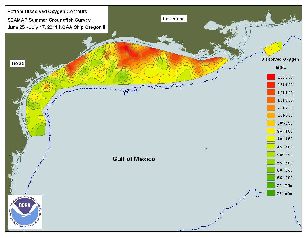
The gulf contains a hypoxic dead zone that runs east–west along the Texas–Louisiana coastline. In July 2008, researchers reported that between 1985 and 2008, the area roughly doubled in size. It was 22730 km2 in 2017, the largest ever recorded. Poor agricultural practices in the northern portion of the Gulf of Mexico have led to a tremendous increase of nitrogen and phosphorus in neighboring marine ecosystems, which has resulted in algae blooms and a lack of available oxygen. Occurrences of virilization and estrogen suppression were observed as a result. A 2007 study of the Atlantic croaker found a disproportioned sex ratio of 61% males to 39% females in hypoxic sites. This was compared with a 52% to 48% male-female ratio found in reference sites, showing impaired reproductive output for fish populations inhabiting hypoxic coastal zones.
Oil spills
According to the National Response Center, the oil industry has thousands of minor accidents annually in the Gulf of Mexico. The gulf's largest oil spill to date began in June 1979, when the Ixtoc I oil platform in the Bay of Campeche suffered a blowout and a catastrophic explosion, and lasted until the well was finally capped in April 1980.
On April 20, 2010, the Deepwater Horizon oil platform, located in the Mississippi Canyon about 64 km off the Louisiana coast and operated by the British multinational company BP, suffered a catastrophic explosion and later sank. Oil flowed from the wellhead, about 1.5 km below the surface on the ocean floor, creating a slick that covered hundreds of square kilometers of ocean surface, threatening marine life, adjacent coastal wetlands, and the livelihoods of Gulf Coast shrimpers and fishermen. Estimates of the daily flow jumped several times—on April 24, it was 160 m3 by BP's estimate; on April 28, a NOAA scientist increased the estimate to 5000 oilbbl; and on May 27, the USGS put the rate at 12000 –. Final estimates suggested a leak of 62000 oilbbl/d, a scale that had been suggested by both independent observers and federal scientists early on, but official attempts to release modeling data had been suppressed by the White House Office of Management and Budget, according to a report by the government commission investigating the response. On July 15, BP announced that the leak had stopped. In July, BP agreed to pay $18.7 billion to the U.S. government, the states of Alabama, Florida, Louisiana, Mississippi, and Texas, as well as 400 local authorities. , BP had spent $54 billion on cleanup, penalties, and to repair environmental and economic damage.
Brutus oil spillOn May 12, 2016, oil from subsea infrastructure on Shell's Brutus oil rig released 2,100 barrels of oil. This leak created a 5 to 34 km oil slick in the sea about 156 km south of Port Fourchon, Louisiana, according to the U.S. Bureau of Safety and Environmental Enforcement.
Meteorological significance
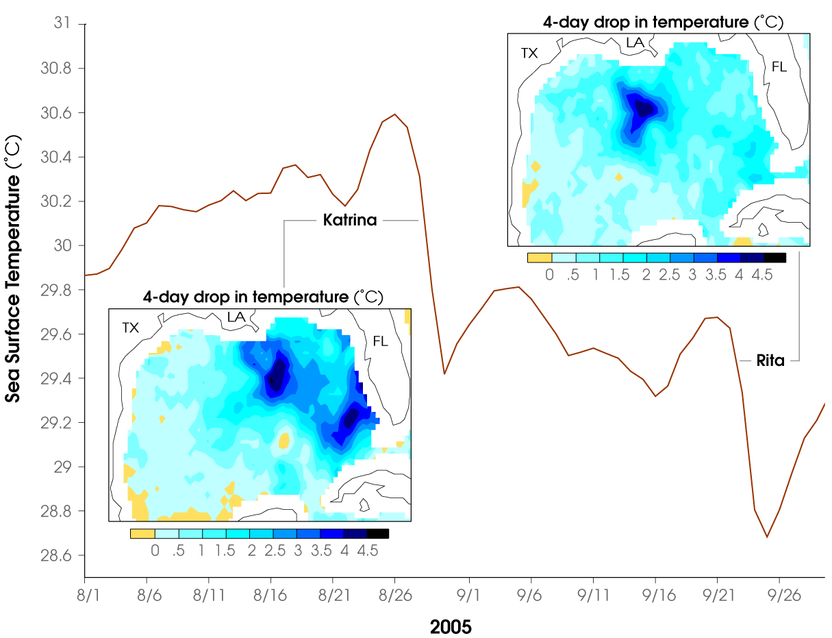
The gulf's warm sea surface temperatures can feed powerful, deadly, and destructive Atlantic hurricanes such as Hurricane Katrina in 2005. In the open Atlantic, a hurricane will draw up cool water from the depths, making it less likely that further hurricanes will follow (warm water being one of the preconditions necessary for their formation). However, the gulf is shallower; when a hurricane passes over, the water temperature may drop, but it soon rebounds enough to support another tropical cyclone. From 1970 to 2020, surface temperatures warmed at about twice the rate observed for the global ocean surface.
Moisture from the Gulf of Mexico is a primary factor for the development of tornadoes and other severe weather in Tornado Alley, a term used to describe an area of the United States that is one of the most tornado-prone areas in the world. Dry air from the Rocky Mountains converges with Gulf moisture in the area, which produces storms and supercells that produce some of the most violent tornadoes in the world. A study published in the Journal of Climate by Dongmin Kim, Sang-Ki Lee, and Hosmay Lopez, found that the Madden–Julian oscillation strengthens the North American low-level jet, which increases the flow of Gulf moisture and atmospheric instability into the Central United States, furthering tornadogenesis in the region.
Notes
References
References
- "General Facts about the Gulf of Mexico". GulfBase.org.
- {{lang. es. México in {{lang. es. [[Diccionario panhispánico de dudas]] by [[Royal Spanish Academy]] and [[Association of Academies of the Spanish Language]], Madrid: Santillana. 2005. ISBN 978-8-429-40623-8.
- "Gulf of Mexico Region".
- (January 1, 2000). "Gulf of Mexico". [[Geographic Names Information System]].
- "General Facts about the Gulf of Mexico". [[United States Environmental Protection Agency]].
- (September 4, 2024). "Gulf of Mexico Fact Sheet". [[United States Energy Information Administration]].
- Dvorak, Petula. (January 15, 2025). "The Gulf of Mexico's long history of colonization and varying names". [[The Washington Post]].
- Fernández, Adela. (1992). "Dioses prehispánicos de México: mitos y deidades del panteón náhuatl". Panorama Editorial.
- Schwaller, John Frederick. (January 2006). "The Ilhuica of the Nahua: Is Heaven Just a Place?". [[The Americas (journal).
- Davis, Jack E.. (January 15, 2025). "No One Owns the Gulf of Mexico". The Marjorie.
- Galtsoff, Paul Simon. (1954). "Historical sketch of the explorations in the Gulf of Mexico". [[National Oceanic and Atmospheric Administration]].
- Parker, Susan R.. (February 11, 2012). "Nation's Oldest City: A new name for the Gulf of Mexico?". [[The St. Augustine Record]].
- Siebold, Jim. (January 22, 2017). "Nova et integra universi orbis descripsio [Paris Gilt or De Bure Globe]". Cartographic Images.
- Maggiolo, Vesconte. (1531). "Planisphere".
- Agnese, Battista. (1544). "[Atlas de Battista Agnese]".
- Frum, David. (February 13, 2025). "The 'Gulf of America' Is an Admission of Defeat". [[The Atlantic]].
- Sledge, John S.. (November 13, 2019). "The Gulf of Mexico: A Maritime History". [[University of South Carolina Press]].
- Wagner, James. (January 28, 2025). "'The Gulf of America'? Here's What Mexicans and Cubans Think.". [[The New York Times]].
- Foster, William C.. (January 1, 2010). "Spanish Expeditions into Texas, 1689–1768". [[University of Texas Press]].
- "Map of the New Discovery Made by the Jesuit Fathers in 1672 and Continued by Father Jacques Marquette, from the Same Group, Accompanied by a Few Frenchmen in the Year 1673, Named "Manitounie".". Library of Congress.
- (January 22, 2025). "Along Gulf Coast, Donald Trump's plan for 'Gulf of America' touches residents' pride; some wonder what difference will it make". [[WUFT-FM]].
- (1953). "26.—Gulf of Mexico: Limits of Oceans and Seas: Special Publication No. 23".
- Huet, Michel. (August 6–10, 2001). "Standardisation of Maritime Geographical Names: The Role of the International Hydrographic Organization". [[International Cartographic Association]].
- (January 22, 2025). "Yearbook – Annuaire – Anuario". International Hydrographic Organization.
- Rohrlich, Justin. (January 20, 2025). "Trump to make good on Gulf of America promise with bonkers executive order".
- Rogero, Tiago. (January 20, 2025). "Can Trump really rename the Gulf of Mexico the Gulf of America?". [[The Guardian]].
- Frazin, Rachel. (January 24, 2025). "Feds implement 'Gulf of America,' 'Mount McKinley' name changes". [[The Hill (newspaper).
- (January 31, 2025). "Restoring Names That Honor American Greatness". Federal Register.
- {{GNIS. 558730. Gulf of America
- {{GEOnet3. -1506402. Gulf of America
- Rogers, Reece. (February 11, 2025). "Here's How All Online Maps Are Handling the 'Gulf of Mexico' Name Change".
- Benton, Joshua. "Trump wants news outlets to get on board with 'Gulf of America' — or else. Will they?".
- (February 15, 2025). "Axios to use 'Gulf of America' in compliance with Trump administration". The Hill.
- (February 17, 2025). "Mexico's President Sheinbaum threatens to take legal action over the Gulf name change". [[NPR]].
- Wolf, Zachary B.. (2025-02-13). "Americans voted for Trump. Did they vote for this? {{!}} CNN Politics".
- Franklin, Charles. (2023-10-04). "New Marquette Law School Poll national survey finds public strongly favors some Trump policies, strongly opposes others – Marquette Law School Poll".
- (June 2019). "COASTLINE AMERICA".
- [https://www.census.gov/content/dam/Census/library/visualizations/2019/demo/coastline-america.pdf. U.S. Census Bureau, "Coastline America", (2020)]
- "Censo de Población y Vivienda 2020 – SCITEL" (in Spanish). Retrieved January 26, 2025.
- "Cuba".
- "Population in Administrative Area 1 Places of Cuba".
- (2012). "Wilson cycles, tectonic inheritance, and rifting of the North American Gulf of Mexico continental margin". [[Geosphere (journal).
- (1991). "The Gulf of Mexico Basin: The Geology of North America". Geological Society of America.
- (2010). "The Gulf of Mexico is a Jurassic backarc basin". [[Geosphere (journal).
- Van Arsdale, Roy B.. (2009). "Adventures Through Deep Time: The Central Mississippi River Valley and Its Earthquakes". [[Geological Society of America]].
- (2002). "The Mississippi Embayment, North America: a first order continental structure generated by the Cretaceous superplume mantle event". [[Journal of Geodynamics]].
- (1991). "Introduction to Central Gulf Coast Geology". New Orleans Geological Society.
- Galloway, William E.. (2008). "The Sedimentary Basins of the United States and Canada, Sedimentary Basins". Elsevier.
- (1991). "The Gulf of Mexico Basin: The Geology of North America". [[Geological Society of America]].
- (December 2001). "Cenozoic evolution of sediment accumulation in deltaic and shore-zone depositional systems, Northern Gulf of Mexico Basin". [[Marine and Petroleum Geology]].
- (2017). "Habitats and Biota of the Gulf of Mexico: Before the Deepwater Horizon Oil Spill". Springer.
- (July 6, 2025). "Gulf of Mexico / Gulf of America {{!}} Map, Name, Origin, Ecosystem, & Economic Importance {{!}} Britannica".
- Clarke, Allan. (April 5–7, 1994). "Northeastern Gulf of Mexico Physical Oceanography Workshop Proceedings of a Workshop Held in Tallahassee, Florida".
- Carney, Bob. "Lakes within Oceans".
- "Louann Salt Layer (map)".
- MacDonald, Ian R.. (1992). "Sea-Floor Brine Pools Affect Behavior, Mortality, and Preservation of Fishes in the Gulf of Mexico: Lagerstätten in the Making?". PALAIOS.
- (2005). "Geophysical and geochemical signatures of Gulf of Mexico seafloor brines". Biogeosciences.
- Niiler, Eric. (May 5, 2016). "Deep-Sea Brine Lake Dubbed 'Jacuzzi of Despair'". seeker.com.
- Barker, Graeme. (5 October 2006). "The Agricultural Revolution in Prehistory: Why did Foragers become Farmers?". Oxford University Press.
- Story, Dee Ann. (1985). "Prehistoric Food Production in North America". University of Michigan.
- (September 2022). "Temporality of fishery taskscapes on the north-central Gulf of Mexico coast (USA) during the Middle/Late Woodland period (AD 325–1040)". Journal of Anthropological Archaeology.
- (2000). "Fisherfolk, Farmers and Frenchmen Archaeological Explorations on the Mississippi Gulf Coast". Mississippi Department of Archives and History.
- Milanich, Jerald T.. (2018). "The History of Florida". University of Florida.
- (2018). "Food production in native North America: an archaeological perspective". Society for American Archaeology.
- (December 2009). "Settlement and subsistence among the Early Formative Gulf Olmec". Journal of Anthropological Archaeology.
- (October 2013). "Nonagricultural Cultivation and Social Complexity: The Olmec, Their Ancestors, and Mexico’s Southern Gulf Coast Lowlands". Current Anthropology.
- Andrews, Anthony P.. (October 1991). "America's Ancient Mariners". Natural History.
- Allaire, Louis. (28 March 2008). "The Cambridge History of the Native Peoples of the Americas". Cambridge University Press.
- "Christopher Columbus – The second and third voyages".
- Johnson, Willis Fletcher. (1920). "The History of Cuba". B. F. Buck & Company.
- Knight, Kevin. (2009). "Pierre Le Moyne, Sieur d'Iberville". newadvent.org.
- Roth, David. (2003). "Louisiana Hurricane History: 18th century (1722–1800)". Tropical Weather—National Weather Service—Lake Charles, Louisiana.
- "Gulf of Mexico Watershed". [[United States Environmental Protection Agency]].
- "National Water Program Guidance: FY 2005". [[United States Environmental Protection Agency]].
- "Project Title: Implementation of the Strategic Action Program of the Gulf of Mexico Large Marine Ecosystem: Annex 1: Environmental and Social Management Plan (ESMP)". [[United Nations Environment Programme]].
- "Three Nations, One Gulf: United States, Mexico and Cuba collaborate on marine life issues". Texas Parks and Wildlife Department.
- (June 15, 2010). "Gulf of Mexico". Texas State Historical Association.
- "Central Florida Feels Quake".
- "6.0 Magnitude Earthquake in Gulf of Mexico Shakes Southeast".
- "United States Geological Survey, September 11, 2006".
- (January 2013). "Mexico's Attempt to Extend its Continental Shelf Beyond 200 Nautical Miles Serves as a Model for the International Community, Mexican Law Review, Volume V, Number 2, Jan.– June 2013". Mexican Law Review.
- "FPAN Home".
- "Mystery Mardi Gras Shipwreck".
- (2007). "Mystery Mardi Gras Shipwreck Documentary". The Museum of Underwater Archaeology.
- "The Discovery of U – 166 : Rewriting History with New Technology". Offshore Technology Conference.
- [[Minerals Management Service]] Gulf of Mexico OCS Region (November 2006). "Gulf of Mexico OCS Oil and Gas Lease Sales: 2007–2012. Western Planning Area Sales 204, 207, 210, 215, and 218. Central Planning Area Sales 205, 206, 208, 213, 216, and 222. Draft Environmental Impact Statement. Volume I: Chapters 1–8 and Appendices". U.S. Department of the Interior, Minerals Management Service, Gulf of Mexico OCS Region, New Orleans. page 3-27–3-34 [http://www.gomr.mms.gov/PDFs/2006/2006-062-Vol1.pdf PDF] {{webarchive. link. (March 26, 2009)
- Rosel, E. P.; Corkeron, P.; Engleby, L.; Epperson, D.; Mullin, D. K.; Soldevilla, S. M.; Taylor, L. B. 2016. [http://www.cio.noaa.gov/services_programs/prplans/pdfs/ID337_BrydesWhale_FinalProduct.pdf STATUS REVIEW OF BRYDE'S WHALES (BALAENOPTERA EDENI) IN THE GULF OF MEXICO UNDER THE ENDANGERED SPECIES ACT]. {{Webarchive. link. (August 7, 2020. NOAA Technical Memorandum NMFS-SEFSC-692.)
- Zongker, Brett. (July 21, 2010). "Smithsonian Holdings to Aid Researchers in the Gulf".
- Coddington, Jonathan. (June 15, 2010). "Testimony to the Subcommittee on Insular Affairs, Oceans and Wildlife; Committee on Natural Resources; U.S. House of Representatives". [Smithsonian Ocean Portal].
- Donn, Jeff. (July 7, 2010). "Gulf home to 27,000 abandoned wells". Burlington Free Press.
- Davis, Jack E. (2018). The Gulf: the Making of an American Sea. New York: Liveright Publishing Corp. p. 416. {{ISBN. 978-1-63149-402-4.
- (November 2017). "Abundant plankton-sized microplastic particles in shelf waters of the northern Gulf of Mexico". Environmental Pollution.
- link. (May 3, 2017, ''Washington Post'', July 31, 2008.)
- (August 2, 2017). "New Jersey-Size 'Dead Zone' Is Largest Ever in Gulf of Mexico". National Geographic.
- (2012). "Extensive Reproductive Disruption, Ovarian Masculinization and Aromatase Suppression in Atlantic Croaker in the Northern Gulf of Mexico Hypoxic Zone". Proceedings of the Royal Society B: Biological Sciences.
- (May 13, 2016). "Shell Oil Spill Dumps Nearly 90,000 Gallons of Crude into Gulf".
- [http://www.boston.com/news/nation/articles/2010/04/23/burning_oil_rig_sinks_setting_stage_for_spill_11_still_missing "Burning oil rig sinks, setting stage for spill; 11 still missing"] {{Webarchive. link. (September 6, 2015 , by Kevin McGill and Holbrook Mohr ([[Associated Press]]), ''[[Boston Globe]]'', April 23, 2010)
- Avery, Heidi. (May 5, 2010). "The Ongoing Administration-Wide Response to the Deepwater BP Oil Spill".
- National Commission on the BP Deepwater Horizon Oil Spill and Offshore Drilling. (October 6, 2010). "The Amount and Fate of the Oil".
- [http://www.boston.com/lifestyle/green/articles/2010/04/25/well_from_sunken_rig_leaking_oil "Well from sunken rig leaking oil"] {{Webarchive. link. (June 8, 2015, by Cain Burdeau ([[Associated Press]]), ''[[Boston Globe]]'', April 25, 2010)
- [http://www.boston.com/lifestyle/green/articles/2010/04/27/race_to_plug_leaking_oil_well_off_la_spurs_new_tactics "Race to plug leaking oil well off La. spurs new tactics"] {{Webarchive. link. (June 8, 2015, by Cain Burdeau ([[Associated Press]]), ''[[Boston Globe]]'', April 27, 2010)
- (April 28, 2010). "Size of Spill in Gulf of Mexico Is Larger Than Thought". The New York Times.
- Winerman, Lea. (October 6, 2010). "Report: Government Underestimated, Underreported Oil Spill Size".
- [http://news.nationalgeographic.com/news/2010/05/100527-energy-nation-gulf-oil-spill-top-kill-obama/ "Gulf Oil Spill Worst in U.S. History; Drilling Postponed"] {{Webarchive. link. (January 29, 2019 , by Marianne Lavelle, ''[[National Geographic Society). National Geographic]]'', May 27, 2010
- (July 9, 2015). "BP: Into uncharted waters". Financial Times.
- "Shell's Brutus production platform spills oil into Gulf of Mexico". Washington Post.
- "Warm Waters Provide Fuel for Potential Storms". [[NASA Earth Observatory]].
- (January 30, 2023). "The Gulf of Mexico Is Getting Warmer". [[National Centers for Environmental Information]].
- (July 8, 2019). "Story map: Inside Tornado Alley". [[National Oceanic and Atmospheric Administration]].
- (April 2, 2020). "Is There a Connection Between MJO and Tornadoes in the United States?". Climate Program Office ([[NOAA]]).
- National Geophysical Data Center, 1999. Global Land One-kilometer Base Elevation (GLOBE) v.1. Hastings, D. and P.K. Dunbar. [http://www.ngdc.noaa.gov/mgg/topo/gltiles.html National Geophysical Data Center, NOAA] {{Webarchive. link. (February 10, 2011 . doi:10.7289/V52R3PMS [access date: March 16, 2015])
- (2009). "ETOPO1 1 Arc-Minute Global Relief Model: Procedures, Data Sources and Analysis". NOAA.
- (1986). "An investigation of the circulation of the Gulf of Mexico". Journal of Geophysical Research: Oceans.
- (June 2019). "The Flow through the Gulf of Mexico". Journal of Physical Oceanography.
- (2005). "Circulation in the Gulf of Mexico: Observations and Models". [[American Geophysical Union]].
- (2005). "Circulation in the Gulf of Mexico: Observations and Models". [[American Geophysical Union]].
This article was imported from Wikipedia and is available under the Creative Commons Attribution-ShareAlike 4.0 License. Content has been adapted to SurfDoc format. Original contributors can be found on the article history page.
Ask Mako anything about Gulf of Mexico — get instant answers, deeper analysis, and related topics.
Research with MakoFree with your Surf account
Create a free account to save articles, ask Mako questions, and organize your research.
Sign up freeThis content may have been generated or modified by AI. CloudSurf Software LLC is not responsible for the accuracy, completeness, or reliability of AI-generated content. Always verify important information from primary sources.
Report