From Surf Wiki (app.surf) — the open knowledge base
Gilgit-Baltistan
Region administered by Pakistan

Region administered by Pakistan
| Field | Value |
|---|---|
| name | Gilgit-Baltistan |
| native_name_lang | ur |
| settlement_type | Region administered by Pakistan as an administrative territory |
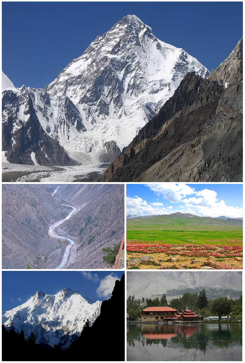
| image_skyline | {{Photomontage |
| photo1a | Trekkers along with porters towards Snow Lake, over Biafo Glacier 61Km.jpg |
| photo2a | Nanga Parbat The Killer Mountain.jpg |
| size | 250 |
| position | center |
| spacing | Number indicating width of spacing between the images (default: 1) |
| color | Color of spacing between the images (default: black) |
| border | Number indicating width of border surrounding the montage (default: 1) |
| color_border | Color of border surrounding the montage (default: black) |
| text_background | Color of background behind text (default: #F8F8FF) |
| foot_montage | Top: Biafo Glacier |
| Bottom: Nanga Parbat Mountain | |
| image_map | File:Kashmir region. LOC 2003626427 - showing sub-regions administered by different countries.jpg |
| map_alt | Map of the disputed Kashmir region showing areas of control by India, Pakistan, and China |
| map_caption | A map of the disputed Kashmir region with the two Pakistan-administered areas shaded in sage-green. |
| mapframe | yes |
| mapframe-zoom | 4 |
| mapframe-marker | city |
| coordinates | |
| subdivision_type | Administering country |
| subdivision_name | Pakistan |
| established_title | Gilgit Rebellion |
| established_date | 1 November 1947 (Gilgit-Baltistan Independence Day) |
| established_title1 | Formation of Northern Areas |
| established_date1 | August 1972 |
| established_title2 | Self-government status granted |
| established_date2 | 29 August 2009 |
| seat_type | Capital |
| seat | Gilgit |
| government_type | Administrative territory |
| government_footnotes | |
| governing_body | Government of Gilgit-Baltistan |
| leader_title | Governor |
| leader_name | Syed Mehdi Shah |
| leader_title1 | Chief Minister |
| leader_name1 | Yar Muhammad (caretaker) |
| leader_title2 | Chief Secretary |
| leader_name2 | Ahmed Ali Mirza (BPS 21-PAS) |
| leader_title3 | Legislature |
| leader_name3 | Gilgit-Baltistan Assembly |
| leader_title4 | High Court |
| leader_name4 | Supreme Appellate Court Gilgit-Baltistan |
| unit_pref | Metric |
| area_total_km2 | 72496 |
| area_note | |
| population_footnotes | |
| population_total | 1,492,924 |
| population_as_of | 2017 |
| population_density_km2 | auto |
| timezone1 | PKT |
| utc_offset1 | +05:00 |
| iso_code | PK-GB |
| blank_name_sec1 | Languages |
| blank_info_sec1 | Balti, Shina, Wakhi, Burushaski, Khowar, Domaki, Purgi, Changthang, Brokskat, Ladakhi, Urdu (administrative) |
| blank_name_sec2 | Assembly seats |
| blank_info_sec2 | 33 |
| blank1_name_sec2 | Divisions |
| blank1_info_sec2 | 3 |
| blank2_name_sec2 | Districts |
| blank2_info_sec2 | 14 |
| blank3_name_sec2 | Tehsils |
| blank3_info_sec2 | 31 |
| blank4_name_sec2 | Union Councils |
| blank4_info_sec2 | 113 |
| blank5_name_sec1 | HDI (2019) |
| blank5_info_sec1 | 0.592 |
| website | |
| native_name |
Bottom: Nanga Parbat Mountain | mapframe-zoom = 4 | mapframe-marker = city
Gilgit-Baltistan (; ), formerly known as the Northern Areas, is a region administered by Pakistan as an administrative territory and consists of the northern portion of the larger Kashmir region, which has been the subject of a dispute between India and Pakistan since 1947 and between India and China since 1959.The application of the term "administered" to the various regions of Kashmir and a mention of the Kashmir dispute is supported by the tertiary sources (a) through (e), reflecting due weight in the coverage. Although "controlled" and "held" are also applied neutrally to the names of the disputants or to the regions administered by them, as evidenced in sources (h) through (i) below, "held" is also considered politicised usage, as is the term "occupied," (see (j) below).
(a) (subscription required) Quote: "Kashmir, region of the northwestern Indian subcontinent ... has been the subject of dispute between India and Pakistan since the partition of the Indian subcontinent in 1947. The northern and western portions are administered by Pakistan and comprise three areas: Azad Kashmir, Gilgit, and Baltistan, the last two being part of a territory called the Northern Areas. Administered by India are the southern and southeastern portions, which constitute the state of Jammu and Kashmir but are slated to be split into two union territories.";
(b) (subscription required) Quote: "Aksai Chin, Chinese (Pinyin) Aksayqin, portion of the Kashmir region, at the northernmost extent of the Indian subcontinent in south-central Asia. It constitutes nearly all the territory of the Chinese-administered sector of Kashmir that is claimed by India to be part of the Ladakh area of Jammu and Kashmir state.";
(c) C. E Bosworth, University of Manchester Quote: "KASHMIR, kash'mer, the northernmost region of the Indian subcontinent, administered partly by India, partly by Pakistan, and partly by China. The region has been the subject of a bitter dispute between India and Pakistan since they became independent in 1947";
(d) Quote: "Jammu and Kashmir: Territory in northwestern India, subject to a dispute between India and Pakistan. It has borders with Pakistan and China."
(e) Quote: "We move from a disputed international border to a dotted line on the map that represents a military border not recognized in international law. The line of control separates the Indian and Pakistani administered areas of the former Princely State of Jammu and Kashmir.";
(f)
(g)
(h) Quote: "J&K: Jammu and Kashmir. The former princely state that is the subject of the Kashmir dispute. Besides IJK (Indian-controlled Jammu and Kashmir. The larger and more populous part of the former princely state. It has a population of slightly over 10 million, and comprises three regions: Kashmir Valley, Jammu, and Ladakh.) and AJK ('Azad" (Free) Jammu and Kashmir. The more populous part of Pakistani-controlled J&K, with a population of approximately 2.5 million.), it includes the sparsely populated "Northern Areas" of Gilgit and Baltistan, remote mountainous regions which are directly administered, unlike AJK, by the Pakistani central authorities, and some high-altitude uninhabitable tracts under Chinese control."
(i) Quote: "Kashmir's identity remains hotly disputed with a UN-supervised "Line of Control" still separating Pakistani-held Azad ("Free") Kashmir from Indian-held Kashmir.";
(j) Quote:"Some politicised terms also are used to describe parts of J&K. These terms include the words 'occupied' and 'held'." It borders Azad Kashmir to the south, the province of Khyber Pakhtunkhwa to the west, the Wakhan corridor of Afghanistan to the north, the Xinjiang region of China to the east and northeast, and the Indian-administered union territories of Jammu and Kashmir and Ladakh to the southeast.
According to UNSC Resolution of 1947 the territory is part of the disputed Kashmir region along with Azad Kashmir, Aksai Chin, the Shaksgam Valley, and Jammu, Ladakh, and the Valley of Kashmir.-- The region, together with Azad Kashmir in the southwest, is grouped and referred to by the United Nations and other international organisations as "Pakistan-administered Kashmir".{{refn|group=note| The Indian government and Indian sources refer to Azad Kashmir and Gilgit-Baltistan as "Pakistan-occupied Kashmir" ("PoK") or "Pakistan-held Kashmir" ("PhK"). Sometimes Azad Kashmir alone is meant by these terms. "Pakistan-administered Kashmir" and "Pakistan-controlled Kashmir" are used by neutral sources. Conversely, Pakistani sources refer to the territories under Indian control as "Indian-occupied Kashmir" ("IoK") or "Indian-held Kashmir" ("IhK"). Gilgit-Baltistan is six times larger than Azad Kashmir in terms of geographical area.
The territory of present-day Gilgit-Baltistan became a separate administrative unit in 1972 under the name "Federally Administered Northern Areas". It was formed by the amalgamation of Gilgit and Baltistan Agencies. In 2009, the region was renamed "Gilgit-Baltistan" and granted limited autonomy through the Self-Governance Order signed by then Pakistani president Asif Ali Zardari, a move that was reportedly intended to also empower the territory's people; however, scholars state that the real power rests with the governor and not with the chief minister or elected assembly. Much of the population of Gilgit-Baltistan reportedly wants the territory to become integrated with Pakistan proper as a fifth province, and opposes integration with the rest of the Kashmir region. The Pakistani government has rejected calls from the territory for provincial status on the grounds that granting such a request would jeopardise Pakistan's demands for the entire Kashmir conflict to be resolved according to all related United Nations resolutions.
Gilgit-Baltistan covers an area of over 72,496 km2 (27,911 sq mi) and is highly mountainous. Its capital and largest city is Gilgit, while Skardu is the second largest city. It had a population of 1.492 million people according to the 2017 national census (estimated to be 1.7 million in 2022). The economy is dominated by agriculture and the tourism industry. The region is home to five of the 14 eight-thousanders, including K2, and has more than fifty mountain peaks above 7,000 metres (23,000 ft). Three of the world's longest glaciers outside of Earth's polar regions are found in Gilgit-Baltistan. The main tourism activities are trekking and mountaineering, and this industry has been growing in importance throughout the region.
History
Main article: History of Gilgit-Baltistan
Early history
The rock carvings found in various places in Gilgit-Baltistan, especially in the Passu village of Hunza, suggest a human presence since 2000 BC.{{cite book |archive-date=8 April 2022 |access-date=5 February 2021 |archive-url=https://web.archive.org/web/20220408151136/https://books.google.com/books?id=6SsBCwAAQBAJ&pg=PT141 |url-status=dead
Between 399 and 414, the Chinese Buddhist pilgrim Faxian visited Gilgit-Baltistan.{{cite book
According to Chinese records from the Tang dynasty, between the 600s and the 700s, the region was governed by a Buddhist dynasty referred to as Bolü (), also transliterated as Palola, Patola, Balur.{{cite book | access-date = 19 February 2017 | access-date = 23 January 2018 | access-date = 19 February 2017
In mid-600s, Gilgit came under Chinese suzerainty after the fall of the Western Turkic Khaganate to Tang military campaigns in the region. In the late 600s CE, the rising Tibetan Empire wrestled control of the region from the Chinese. However, faced with growing influence of the Umayyad Caliphate and then the Abbasid Caliphate to the west, the Tibetans were forced to ally themselves with the Islamic caliphates. The region was then contested by Chinese and Tibetan forces, and their respective vassal states, until the mid-700s.{{Cite book | author-link = Aurel Stein
Between 644 and 655, Navasurendrāditya-nandin became king of the Palola Sāhi dynasty in Gilgit. Numerous Sanskrit inscriptions, including the Danyor Rock Inscriptions, were discovered to be from his reign.
According to Chinese court records, in 717 and 719 respectively, delegations of a ruler of Great Palola (Baltistan) named Su-fu-she-li-ji-li-ni () reached the Chinese imperial court. |trans-title=Complete collection of Tang prose
In 720, the delegation of Surendrāditya () reached the Chinese imperial court. He was referred to in Chinese records as the king of Great Palola; however, it is unknown if Baltistan was under Gilgit rule at the time. |trans-title=New Book of Tang |volume=221
In 721–722, the Tibetan army attempted but failed to capture Gilgit or Bruzha (Yasin Valley). By this time, according to Chinese records, the king of Little Palola was Mo-ching-mang (). He had visited the Tang court requesting military assistance against the Tibetans. Between 723 and 728, the Korean Buddhist pilgrim Hyecho passed through this area. In 737/738, Tibetan troops under the leadership of Minister Bel Kyesang Dongtsab of Emperor Me Agtsom took control of Little Palola. By 747, the Chinese army under the leadership of the ethnic-Korean commander Gao Xianzhi had recaptured Little Palola. | access-date = 22 January 2018 | archive-date = 8 August 2017 | archive-url = https://web.archive.org/web/20170808091432/http://himalaya.socanth.cam.ac.uk/collections/journals/ret/pdf/ret_27_01.pdf | url-status = live
Turkic tribes practising Zoroastrianism arrived in Gilgit during the 7th century, and founded the Trakhan dynasty in Gilgit.
Medieval history
In the 14th century, Sufi Muslim preachers from Persia and Central Asia introduced Islam in Baltistan. Famous among them was Mir Sayyid Ali Hamadani, who came through Kashmir while in the Gilgit region Islam entered in the same century through Turkic Tarkhan rulers. Gilgit-Baltistan was ruled by many local rulers, among whom the Maqpon dynasty of Skardu and the Rajas of Hunza were famous. The Maqpons of Skardu unified Gilgit-Baltistan with Chitral and Ladakh, especially in the era of Ali Sher Khan Anchan
Before the demise of Shribadat, a group of Shina people migrated from Gilgit Dardistan and settled in the Dras and Kharmang areas. The descendants of those Dardic people can be still found today, and are believed to have maintained their Dardic culture and Shina language up to the present time.
Under Princely State of Jammu and Kashmir
.jpg)
In November 1839, Dogra commander Zorawar Singh, whose allegiance was to Gulab Singh, started his campaign against Baltistan.{{cite book
In 1842, Dogra Commander Wasir Lakhpat, with the active support of Ali Sher Khan (III) from Kartaksho, conquered Baltistan for the second time. There was a violent capture of the fortress of Kharphocho. Haidar Khan from Shigar, one of the leaders of the uprising against the Dogras,{{cite book
After the defeat of the Sikhs in the First Anglo-Sikh War, the region became a part of the Jammu and Kashmir princely state, which since 1846 had remained under the rule of the Dogras. The population in Gilgit perceived itself as ethnically different from Kashmiris and disliked being ruled by the Kashmir state. The region remained with the princely state, with temporary leases of some areas assigned to the British, until 1 November 1947.
First Kashmir War
After Pakistan's independence, Jammu and Kashmir initially remained an independent state. Later on 22 October 1947, tribal militias backed by Pakistan crossed the border into Jammu and Kashmir after Poonch rebellion and Jammu Muslim massacre. Hari Singh made a plea to India for assistance and signed the Instrument of Accession, making his state a part of India. India air-lifted troops to defend the Kashmir Valley and the invaders were pushed back behind Uri.
Gilgit's population did not favour the State's accession to India. The Muslims of the frontier ilaqas (Gilgit and the adjoining hill states) had wanted to join Pakistan. Sensing their discontent, Major William Brown, the Maharaja's commander of the Gilgit Scouts, mutinied on 1 November 1947, overthrowing the governor Ghansara Singh. The bloodless coup d'état was planned by Brown to the last detail under the code name "Datta Khel", which was also joined by a rebellious section of the Jammu and Kashmir State Forces under Mirza Hassan Khan. Brown ensured that the treasury was secured and minorities were protected. A provisional government (Aburi Hakoomat) was established by the Gilgit locals with Raja Shah Rais Khan as the president and Mirza Hassan Khan as the commander-in-chief. However, Major Brown had already telegraphed Khan Abdul Qayyum Khan asking Pakistan to take over. Pakistan's political agent, Khan Mohammad Alam Khan, arrived on 16 November and took over the administration of Gilgit. Brown outmaneuvered the pro-Independence group and secured the approval of the mirs and rajas for accession to Pakistan. According to Brown,
The provisional government lasted 16 days. According to scholar Yaqub Khan Bangash, it lacked sway over the population. The Gilgit rebellion did not have civilian involvement and was solely the work of military leaders, not all of whom had been in favour of joining Pakistan, at least in the short term. Historian Ahmed Hasan Dani says that although there had been a lack of public participation in the rebellion, pro-Pakistan sentiments were intense in the civilian population and their anti-Kashmiri sentiments were also clear. According to various scholars, the people of Gilgit as well as those of Chilas, Koh Ghizr, Ishkoman, Yasin, Punial, Hunza and Nagar joined Pakistan by choice.{{cite book|first=Chitralekha|last=Zutshi|title=Languages of Belonging: Islam, Regional Identity, and the Making of Kashmir
After taking control of Gilgit, the Gilgit Scouts along with Azad irregulars moved towards Baltistan and Ladakh and captured Skardu by May 1948. They successfully blocked Indian reinforcements sent to relieve Skardu, and proceeded towards Kargil and Leh. Indian forces mounted an offensive in the autumn of 1948 to push them back from Ladakh, but Baltistan came into the rebels' territory.{{citation
On 1 January 1948, India took the issue of Jammu and Kashmir to the United Nations Security Council. In April 1948, the Council passed a resolution calling for Pakistan to withdraw from all of Jammu and Kashmir and for India to reduce its forces to the minimum level, following which a plebiscite would be held to ascertain the people's wishes. |author-link=Ashutosh Varshney |chapter=Three Compromised Nationalisms: Why Kashmir has been a Problem |chapter-url=https://apps.cndls.georgetown.edu/courses/rudolph/g238/files/Varshney-_1992-Why-Kashmir.pdf |page=212
Inside Pakistan
While the residents of Gilgit-Baltistan expressed a desire to join Pakistan after gaining independence from Maharaja Hari Singh, Pakistan declined to merge the region into itself because of the territory's link to Jammu and Kashmir. For a short period after joining Pakistan, Gilgit-Baltistan was governed by Azad Kashmir if only "theoretically, but not practically" through its claim of being an alternative government for Jammu and Kashmir. In 1949, the Government of Azad Kashmir handed over the administration of Gilgit-Baltistan to the federal government under the Karachi Agreement. According to Indian journalist Paul Sahni, this is seen as an effort by Pakistan to legitimise its rule over Gilgit-Baltistan.
According to Pakistani analyst Ershad Mahmud, there were two reasons why administration was transferred from Azad Kashmir to Pakistan:
- the region was inaccessible from Azad Kashmir, and
- because both the governments of Azad Kashmir and Pakistan knew that the people of the region were in favour of joining Pakistan in a potential referendum over Kashmir's final status.
According to the International Crisis Group, the Karachi Agreement is highly unpopular in Gilgit-Baltistan because Gilgit-Baltistan was not a party to it even while it was its own fate was being decided.
From then until the 1990s, Gilgit-Baltistan was governed through the colonial-era Frontier Crimes Regulations, which were originally created for the northwest tribal regions. They treated tribal people as "barbaric and uncivilised," levying collective fines and punishments. People had no right to legal representation or appeal. Members of tribes had to obtain prior permission from the police to travel anywhere, and had to keep the police informed about their movements. There was no democratic set-up during this period. All political and judicial powers remained in the hands of the Ministry of Kashmir Affairs and Northern Areas (KANA). The people of Gilgit-Baltistan were deprived of rights enjoyed by citizens of Pakistan and Azad Kashmir.
A primary reason for this state of affairs was the remoteness of Gilgit-Baltistan. Another factor was that the whole of Pakistan itself was deficient in democratic norms and principles, therefore the federal government did not prioritise democratic development in the region. There was also a lack of public pressure as an active civil society was absent in the region, with young educated residents usually opting to live in Pakistan's urban centers instead of staying in the region.
Northern Areas
The Shaksgam tract was ceded by Pakistan to China following the signing of the Sino-Pakistani Frontier Agreement in 1963. In 1969, a Northern Areas Advisory Council (NAAC) was created, later renamed to Northern Areas Council (NAC) in 1974 and Northern Areas Legislative Council (NALC) in 1994. But it was devoid of legislative powers. All law-making was concentrated in the KANA Ministry of Pakistan. In August 1972 the two parts of the territory, viz., the Gilgit Agency and Baltistan Agency, along with Nagar state, were merged into a single administrative unit, and given the name "Northern Areas" and two districts, Gilgit and Baltistan, were formed. In September 1974, in a visit to Northern Areas the Pakistani prime minister Zulfiqar Ali Bhutto announced the abolition of Hunza state. Same year the former State Subject law was abolished in Gilgit Baltistan, and Pakistanis from other areas could buy land and settle.
In 1984 the territory's importance shot up within Pakistan with the opening of the Karakoram Highway and the region's population became more connected to mainland Pakistan. The improved connectivity facilitated the local population to avail itself of educational opportunities in the rest of Pakistan. It also allowed the political parties of Pakistan and Azad Kashmir to set up local branches, raise political awareness in the region. According to Ershad Mahmud, these Pakistani political parties have played a 'laudable role' in organising a movement for democratic rights among the residents of Gilgit-Baltistan. In the 1988 Gilgit Massacre, groups of Islamist Sunnis, supported by Osama bin Laden, Pervez Musharraf, General Zia-ul Haq and Mirza Aslam Beg killed hundreds of local Shias. In 1994, a Legal Framework Order (LFO) was created by the KANA Ministry to serve as the de facto constitution for the region.
Present structure
In the late 1990s, the President of Al-Jihad Trust filed a petition in the Supreme Court of Pakistan to determine the legal status of Gilgit-Baltistan. In its judgement of 28 May 1999, the Court directed the Government of Pakistan to ensure the provision of equal rights to the people of Gilgit-Baltistan, and gave it six months to do so. Following the Supreme Court decision, the government took several steps to devolve power to the local level. However, in several policy circles, the point was raised that the Pakistani government was helpless to comply with the court verdict because of the strong political and sectarian divisions in Gilgit-Baltistan and also because of the territory's historical connection with the still disputed Kashmir region, and that this prevented the determination of Gilgit-Baltistan's real status.
A position of 'Deputy Chief Executive' was created to act as the local administrator, but the real powers still rested with the 'Chief Executive', who was the Federal Minister of KANA. "The secretaries were more powerful than the concerned advisors," in the words of one commentator. In spite of various reforms packages over the years, the situation is essentially unchanged. Meanwhile, public rage in Gilgit-Baltistan "[grew] alarmingly." Prominent "antagonist groups" have mushroomed protesting the absence of civic rights and democracy. The Pakistani government has debated granting provincial status to Gilgit-Baltistan.{{cite news |url-status=dead |access-date=24 January 2019 |archive-date=23 October 2019 |archive-url=https://web.archive.org/web/20191023193246/https://unpo.org/members/8727 |url-status=live According to Antia Mato Bouzas, the PPP-led Pakistani government has attempted a compromise through its 2009 reforms between its traditional stand on the Kashmir dispute and the demands of locals, most of whom may have pro-Pakistan sentiments. While the 2009 reforms have added to the self-identification of the region, they have not resolved the constitutional status of the region within Pakistan.
According to 2010 news reports, the people of Gilgit-Baltistan want to merge into Pakistan as a separate fifth province.{{Cite news |access-date=27 December 2016 |archive-date=20 March 2017 |archive-url=https://web.archive.org/web/20170320001447/http://archive.indianexpress.com/news/gilgitbaltistan-a-question-of-autonomy/519428/2 |url-status=live |access-date=27 December 2016 |archive-date=28 June 2021 |archive-url=https://web.archive.org/web/20210628005734/https://www.reuters.com/article/us-pakistan-election-idUSTRE5AB1ZE20091112 |url-status=live |access-date=27 December 2016 |archive-date=13 February 2017 |archive-url=https://web.archive.org/web/20170213194253/http://www.dawn.com/news/1193315 |url-status=live
In 2016, for the first time in the country's constitution, Gilgit-Baltistan was mentioned by name. In 2020, the then Pakistani prime minister Imran Khan announced that Gilgit-Baltistan would attain provisional provincial status after the 2020 Gilgit-Baltistan Assembly election.
In September 2020, it was reported that Pakistan decided to elevate Gilgit-Baltistan's status to that of a full-fledged province.{{cite web |access-date=1 October 2020 |archive-date=3 October 2020 |archive-url=https://web.archive.org/web/20201003021145/https://www.thehindu.com/news/international/pak-to-make-gilgit-baltistan-a-full-fledged-province-report/article32633442.ece |url-status=live
Government
Main article: Government of Gilgit-Baltistan

The territory of present-day Gilgit-Baltistan became a separate administrative unit in 1970 under the name "Northern Areas". It was formed by the amalgamation of the Gilgit Agency, the tribal areas of Darel and Tangir and the Baltistan District (later agency) of the Ladakh Wazarat of the former princely state. It presently consists of fourteen districts, has a population of 1.492 million and an area of approximately 28000 sqmi, and shares borders with Pakistan, China, Afghanistan, and India.
While under the Pakistani administrative jurisdiction since the First Kashmir War, Gilgit-Baltistan has never been formally integrated into the state and does not participate in the country's constitutional political affairs. The Government of Pakistan abolished State Subject Rule in Gilgit-Baltistan in 1974, allowing people from outside Gilgit Baltistan to buy land in the territory. In 1993, an attempt was made by the High Court of Azad Jammu and Kashmir to annexe Gilgit-Baltistan but was quashed by the Supreme Court of Pakistan after protests by the locals of Gilgit-Baltistan, who feared domination by the Kashmiris. On 29 August 2009, the Gilgit-Baltistan Empowerment and Self-Governance Order 2009, was passed by the Pakistani cabinet and later signed by the then President of Pakistan Asif Ali Zardari. The order granted self-rule to the people of Gilgit-Baltistan, by creating, among other things, an elected Gilgit-Baltistan Legislative Assembly and Gilgit-Baltistan Council. Gilgit-Baltistan thus gained a de facto province-like status without constitutionally becoming part of Pakistan. In 2020 Imran Khan Government announced that it would be granted provisional provincial status, and the Pakistani political parties agreed to pass constitutional amendment to propose Gilgit-Baltistan as a province.
Currently, Gilgit-Baltistan is neither a province nor a state. It has a semi-provincial status. Traditionally, the Pakistani government had rejected Gilgit-Baltistani calls for integration with Pakistan on the grounds that it would jeopardise its demands for the whole Kashmir issue to be resolved according to UN resolutions. Some Kashmiri nationalist groups, such as the Jammu and Kashmir Liberation Front, claim Gilgit-Baltistan as part of a future independent state to match what existed in 1947. India, on the other hand, maintains that Gilgit-Baltistan is a part of the former princely state of Jammu and Kashmir that is "an integral part of the country [India]."{{cite news |url=https://timesofindia.indiatimes.com/india/Gilgit-Baltistan-part-of-Jammu-and-Kashmir-India/articleshow/1445666.cms |archive-url=https://web.archive.org/web/20131004213500/http://articles.timesofindia.indiatimes.com/2006-03-10/india/27816766_1_gilgit-baltistan-jammu-and-kashmir-new-map |url-status=live |archive-date=4 October 2013 |newspaper=The Times of India |title=Gilgit-Baltistan part of Jammu and Kashmir: India
Administrative subdivisions
Main article: List of districts in Gilgit-Baltistan


Gilgit-Baltistan is administratively divided into three divisions: Baltistan, Diamer and Gilgit, which, in turn, are divided into fourteen districts. consisting of five Baltistan districts of Skardu, Roundu, Shigar, Kharmang, and Ghanche, and the four Gilgit districts of Gilgit, Ghizer, Hunza and Nagar while four districts of Diamer, Darel, Tangir and Astore are part of Diamer Division. -- The principal administrative centers are the towns of Gilgit and Skardu.
| Division | District | title=Gilgit Baltistan at a Glance 2022. Published in 2023 | url=http://src.pnd.gog.pk/GBatGlance/GBatGlance2023.pdf | access-date=6 April 2025 | website=Planning & Development Department Statistical & Research Cell (SRC), Government of Gilgit-Baltistan.}} | Capital | Population (2022) | Divisional Capital |
|---|---|---|---|---|---|---|---|---|
| **Baltistan** | Ghanche | 8,531 | Khaplu | 181,610 | **Skardu** | |||
| Shigar | 4,173 | Shigar | 84,662 | |||||
| Kharmang | 6,144 | Kharmang | 58,303 | |||||
| Skardu | 10,168 | Skardu | 312,875 | |||||
| Roundu | NA (Incl. in Skardu District.) | Dambudas | NA (Incl. in Skardu District.) | |||||
| **Gilgit** | Gilgit | 4,208 | Gilgit | 338,968 | **Gilgit** | |||
| Ghizer | 12,381 | Gahkuch | 189,530 | |||||
| Hunza | 10,109 | Aliabad | 52,652 | |||||
| Nagar | 4,137 | Nagar | 78,114 | |||||
| Gupis–Yasin | NA (Incl. in Ghizer District.) | Phander | NA (Incl. in Ghizer District.) | |||||
| **Diamer** | Diamer | 7,234 | Chilas | 323,643 | **Chilas** | |||
| Astore | 5,411 | Eidghah | 102,738 | |||||
| Darel | NA (Incl. in Diamer District.) | Darel | NA (Incl. in Diamer District.) | |||||
| Tangir | NA (Incl. in Diamer District.) | Tangir | NA (Incl. in Diamer District.) |
The population of Gilgit-Baltistan was estimated to be 1,713,778 in 2022 by the Government of Gilgit Baltistan. The overall population growth rate between 1998 and 2011 was 63.1% making it 4.85% annually.
Security
Security in Gilgit-Baltistan is provided by the Gilgit-Baltistan Police, the Gilgit Baltistan Scouts (a paramilitary force), and the Northern Light Infantry (part of the Pakistani Army).
The Gilgit-Baltistan Police (GBP) is responsible for law enforcement in Gilgit-Baltistan. The mission of the force is the prevention and detection of crime, maintenance of law and order and enforcement of the Constitution of Pakistan.
Geography and climate
Main article: Geography of Gilgit-Baltistan
Gilgit-Baltistan borders Pakistan's Khyber Pukhtunkhwa province to the west, a small portion of the Wakhan corridor of Afghanistan to the north, China's Xinjiang Uyghur Autonomous Region to the northeast, the Indian-administered Jammu and Kashmir to the southeast, and the Pakistani-administered state of Azad Jammu and Kashmir to the south.
Gilgit-Baltistan is home to all five of Pakistan's "eight-thousanders" and to more than fifty peaks above 7000 m. Gilgit and Skardu are the two main hubs for expeditions to those mountains. The region is home to some of the world's highest mountain ranges. The main ranges are the Karakoram and the western Himalayas. The Pamir Mountains are to the north, and the Hindu Kush lies to the west. Among the highest mountains are K2 (Mount Godwin-Austen) and Nanga Parbat, the latter being one of the most feared mountains in the world.
Three of the world's longest glaciers outside the polar regions are found in Gilgit-Baltistan: the Biafo Glacier, the Baltoro Glacier, and the Batura Glacier. There are, in addition, several high-altitude lakes in Gilgit-Baltistan:
- Sheosar Lake in the Deosai Plains, Skardu
- Naltar lakes in the Naltar Valley, Gilgit
- Satpara Tso Lake in Skardu, Baltistan
- Katzura Tso Lake in Skardu, Baltistan
- Zharba Tso Lake in Shigar, Baltistan
- Phoroq Tso Lake in Skardu, Baltistan
- Lake Kharfak in Gangche, Baltistan
- Byarsa Tso Lake in Gultari, Astore
- Borith Lake in Gojal, upper Hunza, Gilgit
- Rama Lake near Astore
- Rush Lake near Nagar, Gilgit
- Kromber Lake at Kromber Pass, Ishkoman Valley, Ghizer District
- Barodaroksh Lake in Bar Valley, Nagar
- Ghorashi Lake in Ghandus Valley, Kharmang
The Deosai Plains are located above the tree line and constitute the second-highest plateau in the world after Tibet, at 4115 m. The plateau lies east of Astore, south of Skardu and west of Ladakh. The area was declared as a national park in 1993. The Deosai Plains cover an area of almost 5000 km2. For over half the year (between September and May), Deosai is snow-bound and cut off from rest of Astore and Baltistan in winters. The village of Deosai lies close to Chilum chokki and is connected with the Kargil district of Ladakh through an all-weather road.
File:Lake Sudpara.JPG|Satpara Lake, Skardu, in 2002 File:Beauty - Uppaer Kachura Lake Sakardu.jpg|Upper Kachura Lake File:Shangri-La, Skardu.jpg|Shangrila Lake, Skardu File:Mantoka Waterfall Skardu.jpg|Manthokha Waterfall
Rock art and petroglyphs
There are more than 50,000 pieces of rock art (petroglyphs) and inscriptions all along the Karakoram Highway in Gilgit-Baltistan, concentrated at ten major sites between Hunza and Shatial. The carvings were left by invaders, traders, and pilgrims who passed along the trade route, as well as by locals. The earliest date back to between 5000 and 1000 BCE, showing single animals, triangular men and hunting scenes in which the animals are larger than the hunters. These carvings were pecked into the rock with stone tools and are covered with a thick patina that proves their age.
The ethnologist has pieced together the history of the area from inscriptions and recorded his findings in Rock Carvings and Inscriptions in the Northern Areas of Pakistan and the later-released Between Gandhara and the Silk Roads — Rock Carvings Along the Karakoram Highway. Many of these carvings and inscriptions will be inundated and/or destroyed when the planned Basha-Diamir dam is built and the Karakoram Highway is widened.
Climate


The climate of Gilgit-Baltistan varies from region to region, since the surrounding mountain ranges create sharp variations in weather. The eastern part has the moist zone of the western Himalayas, but going toward Karakoram and Hindu Kush, the climate gets considerably drier.{{cite web |access-date = 11 June 2009 |archive-url = https://web.archive.org/web/20090904044602/http://www.wwfpak.org/nap/dnap_climatechange.php |archive-date = 4 September 2009 |url-status = dead
There are towns like Gilgit and Chilas that are very hot during the day in summer yet cold at night and valleys like Astore, Khaplu, Yasin, Hunza, and Nagar, where the temperatures are cold even in summer.
Climate Change Effects
Main article: 2022 Gilgit-Baltistan floods
Climate change has adversely effected this region with more rains every year. On 26 August 2022, most villages in Ghizer district and Hunza were severely effected by the ongoing flooding displacing many people.
Economy and resources
The economy of the region is primarily based on a traditional trade route, the historic Silk Road. The China Trade Organization forum led the people of the area to actively invest and learn modern trade know-how from their Chinese neighbour, Xinjiang. Later, the establishment of a chamber of commerce and the Sust dry port in Gojal Hunza are milestones. The rest of the economy is shouldered by mainly agriculture and tourism. Agricultural products are wheat, corn (maize), barley, and fruits. Tourism is mostly in trekking and mountaineering, and this industry is growing in importance. , the gross state product (GSP) nominal of Gilgit-Baltistan was $2.5 billion and GSP (nominal) per capita of Gilgit-Baltistan was $1,748. GSP purchasing power parity (PPP) of Gilgit-Baltistan was $10 billion and GSP (PPP) per capita of GB was $6,028.
In early September 2009, Pakistan signed an agreement with the People's Republic of China for a major energy project in Gilgit-Baltistan which includes the construction of a 7,000-megawatt dam at Bunji in the Astore District.
Mountaineering

Gilgit-Baltistan is home to more than 20 peaks of over 20000 ft, including K-2 the second highest mountain on Earth. Other well known peaks include Masherbrum (also known as K1), Broad Peak, Hidden Peak, Gasherbrum II, Gasherbrum IV, and Chogolisa, situated in Khaplu Valley. The following peaks have so far been scaled by various expeditions:
| Name of Peak | Photos | Height | First known ascent | Location | ||
|---|---|---|---|---|---|---|
| 1.K-2 | [[File:K2 2006b.jpg | 100px]] | (28,250 ft) | 31 July 1954 | Karakoram | |
| 2. Nanga Parbat | [[File:Nanga Parbat The Killer Mountain.jpg | 100px]] | (26,660 ft) | 3 July 1953 | Himalaya | |
| 3. Gasherbrum I | [[File:Gasherbrum2.jpg | 100px]] | (26,360 ft) | 7 July 1956 | Karakoram | |
| 4. Broad Peak | [[File:7 15 BroadPeak.jpg | 100px]] | (26,550 ft) | 9 June 1957 | Karakoram | |
| 5. Muztagh Tower | [[File:MuztaghTower.jpg | 100px]] | (23,800 ft) | 6 August 1956 | Karakoram | |
| 6. Gasherbrum II | [[File:Gasherbrum2.jpg | 100px]] | (26,120 ft) | 4 July 1958 | Karakoram | |
| 7. Hidden Peak | [[File:HiddenPeak.jpg | 100px]] | (26,470 ft) | 4 July 1957 | Karakoram | |
| 8. Khunyang Chhish | [[File:Kunyang Pumari Chhish.JPG | 100px]] | (25,761 ft) | 4 July 1971 | Karakoram | |
| 9. Masherbrum | [[File:Masherbrum.jpg | 100px]] | (25,659 ft) | 4 August 1960 | Karakoram | |
| 10. Saltoro Kangri | [[File:Saltoro Kangri.jpg | 100px]] | (25,400 ft) | 4 June 1962 | Karakoram | |
| 11. Chogolisa | [[File:Chogolisa.jpg | 100px]] | (25,148 ft) | 4 August 1963 | Karakoram |
Basic facilities

Gilgit has not received a gas pipeline infrastructure since Pakistan's independence, unlike other cities. Through the importation of gas cylinders from other provinces, many private gas contractors offer gas cylinders. The LPG (Liquefied Petroleum Gas) Air Mix Plant project by Sui Northern Gas Pipelines Limited was unveiled in 2020 with the goal of bringing the gas facility to Gilgit. This will significantly reduce deforestation as public uses wood from trees for heating and lighting purpose. The first head office has been built in Gilgit City.
Tourism
Main article: Tourism in Gilgit-Baltistan
Gilgit Baltistan is the capital of tourism in Pakistan. Gilgit Baltistan is home to some of the highest peaks in the world, including K2 the second highest peak in the world. Gilgit Baltistan's landscape includes mountains, lakes, glaciers and valleys. Gilgit Baltistan is not only known for its mountains — it is also visited for its landmarks, culture, history and people. K2 Basecamp, Deosai, Naltar, Fairy Meadows Bagrot Valley and Hushe valley are common places to visit in Gilgit Baltistan.
Transport
Main article: Provincial Highways of Gilgit-Baltistan


Before 1978, Gilgit-Baltistan was cut off from the rest of the Pakistan and the world due to the harsh terrain and the lack of accessible roads. All of the roads to the south opened toward the Pakistan-administered state of Azad Kashmir and to the southeast toward the present-day Indian-administered Jammu and Kashmir. During the summer, people could walk across the mountain passes to travel to Rawalpindi. The fastest way to travel was by air, but air travel was accessible only to a few privileged local people and to Pakistani military and civilian officials. Then, with the assistance of the Chinese government, Pakistan began construction of the Karakoram Highway (KKH), which was completed in 1978. The journey from Rawalpindi / Islamabad to Gilgit takes approximately 20 to 24 hours.
The Karakoram Highway connects Islamabad to Gilgit and Skardu, which are the two major hubs for mountaineering expeditions in Gilgit-Baltistan. Northern Areas Transport Corporation (NATCO) offers bus and jeep transport service to the two hubs and several other popular destinations, lakes, and glaciers in the area. Landslides on the Karakoram Highway are very common. The Karakoram Highway connects Gilgit to Tashkurgan Town, Kashgar, China via Sust, the customs and health-inspection post on the Gilgit-Baltistan side, and the Khunjerab Pass, the highest paved international border crossing in the world at 4693 m.
In March 2006, the respective governments announced that, commencing on 1 June 2006, a thrice-weekly bus service would begin across the boundary from Gilgit to Kashgar and road-widening work would begin at 600 km of the Karakoram Highway. There would also be one daily bus in each direction between the Sust and Taxkorgan border areas of the two political entities.

Pakistan International Airlines used to fly a Fokker F27 Friendship daily between Gilgit Airport and Benazir Bhutto International Airport. The flying time was approximately 50 minutes, and the flight was one of the most scenic in the world, as its route passed over Nanga Parbat, a mountain whose peak is higher than the aircraft's cruising altitude. However, the Fokker F27 was retired after a crash at Multan in 2006. Currently, flights are being operated by PIA to Gilgit on the brand-new ATR 42–500, which was purchased in 2006. With the new plane, the cancellation of flights is much less frequent. Pakistan International Airlines also offers regular flights of a Boeing 737 between Skardu and Islamabad. All flights are subject to weather clearance; in winter, flights are often delayed by several days.
A railway through the region has been proposed; see Khunjerab Railway for details.
Demographics
Population
The population of Gilgit Baltistan is 1,492,924 as of 2017, up from 873,000 in 1998. It was estimated to be 1.7 million in 2022. Around 20% of population is based in the cities of Gilgit and Skardu. Approximately 16.5% of the population was urban in 2017. The fertility rate is 4.7 children per woman, which is the highest in Pakistan.
The population of Gilgit-Baltistan consists of many diverse linguistic, ethnic, and religious sects, due in part to the many isolated valleys separated by some of the world's highest mountains. The ethnic groups include Shins, Yashkuns, Kashmiris, Kashgaris, Pamiris, Pathans, and Kohistanis. A significant number of people from Gilgit-Baltistan are residing in other parts of Pakistan, mainly in Punjab and Karachi. The literacy rate of Gilgit-Baltistan is approximately 72%.
In 2017 census, Gilgit District has the highest population of 330,000 and Hunza District the lowest of 50,000.
Languages
Gilgit-Baltistan is a multilingual region where Urdu being a national and official language serves as the lingua franca for inter ethnic communications. English is co-official and also used in education, while Arabic is used for religious purposes. The table below shows a break-up of Gilgit-Baltistan first-language speakers.
| Rank | Language | Detail | Shina | Balti | Burushaski | Khowar | Wakhi | Others | |||
|---|---|---|---|---|---|---|---|---|---|---|---|
| 1 | It is a Dardic language spoken by the majority in six *tehsils* (Gilgit, Diamir/Chilas, Darel/Tangir, Astore, Puniyal/Gahkuch and Rondu). | ||||||||||
| 2 | It is spoken by the majority in five *tehsils* (Skardu/Shigar, Kharmang, Gultari, Khaplu and Mashabrum). It is from the Tibetan language family and has Urdu borrowings. | ||||||||||
| 3 | It is spoken by the majority in four *tehsils* (Nagar 1, Hunza/Aliabad, Nagar II, and Yasin). It is a language isolate that has borrowed considerable Urdu vocabulary. | ||||||||||
| 4 | It is spoken by the majority in two *tehsils* (Gupis and Ishkomen) but also spoken in Yasin and Puniyal/Gahkuch Tehsils. Like Shina, it is a Dardic language. | ||||||||||
| 5 | It is spoken by the majority of people in Gojal Tehsil of Hunza. But it is also spoken in the Yasin and Ishkomen tehsils of Gupis-Yasin and Ghizer districts. It is classified as eastern Iranian/ Pamiri language. | ||||||||||
| Unranked | Pashto, Kashmiri, Domaaki (spoken by musician clans in the region) and Gojri languages are also spoken by a significant population of the region. |
Religion

The population of Gilgit-Baltistan is entirely Muslim and is denominationally the most diverse in the country. The region is also the only Shia-plurality area in an otherwise Sunni-dominant Pakistan. People in the Skardu district are mostly Shia, while Diamir and Astore districts have Sunni majorities. Ghanche has a Noorbakhshi population, and Ghizar has an Ismaili majority. The populations in Gilgit, Hunza and Nagar districts are composed of a mix of all of these sects. Recent surveys show that Shia Ismaili women, both rural and urban, have high rates of contraceptives usage and low fertility rates; by contrast Sunni women, especially in rural areas, have low rates of contraceptive usage and high fertility rates.
| Religious | |||||||||||||||||||||||||||||||||||||||||||
|---|---|---|---|---|---|---|---|---|---|---|---|---|---|---|---|---|---|---|---|---|---|---|---|---|---|---|---|---|---|---|---|---|---|---|---|---|---|---|---|---|---|---|---|
| group | 1891 | 1901 | 1911 | 1921 | 1931 | 1941 | Pop. | % | Pop. | % | Pop. | % | Pop. | % | Pop. | % | Pop. | % | Islam [[File:Star and Crescent.svg | 15px]] | Tribal | Buddhism [[File:Dharma_Wheel_(2).svg | 15px]] | Hinduism [[File:Om.svg | 15px]] | Christianity [[File:Christian cross.svg | 15px]] | Sikhism [[File:Khanda.svg | 15px]] | Jainism [[File:Jain_Prateek_Chihna.svg | 15px]] | Zoroastrianism [[File:Faravahar.svg | 15px]] | Judaism [[File:Star_of_David.svg | 15px]] | Others | Total population | 127,094 | 60,885 | 78,404 | 89,697 | 96,446 | 116,047 |
| 110,161 | 58,779 | 77,189 | 88,643 | 94,940 | 115,601 | ||||||||||||||||||||||||||||||||||||||
| 16,615 | 0 | 2 | |||||||||||||||||||||||||||||||||||||||||
| 239 | 0 | 0 | 0 | 0 | 0 | ||||||||||||||||||||||||||||||||||||||
| 77 | 2,001 | 1,112 | 948 | 1,361 | 295 | ||||||||||||||||||||||||||||||||||||||
| 2 | 28 | 22 | 16 | 49 | 28 | ||||||||||||||||||||||||||||||||||||||
| 0 | 74 | 81 | 90 | 93 | 121 | ||||||||||||||||||||||||||||||||||||||
| 0 | 1 | 0 | 0 | 3 | 0 | ||||||||||||||||||||||||||||||||||||||
| 0 | 0 | 0 | 0 | 0 | 0 | ||||||||||||||||||||||||||||||||||||||
| 0 | |||||||||||||||||||||||||||||||||||||||||||
| 0 | 2 | 0 | 0 | 0 | 0 | ||||||||||||||||||||||||||||||||||||||
| Note1: 1891 figure taken from census data using the total population of Skardu District and Gilgit District in the Princely State of Jammu and Kashmir that ultimately would be administered by Pakistan, in the contemporary administrative territory of Gilgit–Baltistan. | |||||||||||||||||||||||||||||||||||||||||||
| Note2: 1901 figure taken from census data using the total population of Gilgit District in the Princely State of Jammu and Kashmir that ultimately would be administered by Pakistan, in the contemporary administrative territory of Gilgit–Baltistan. | |||||||||||||||||||||||||||||||||||||||||||
| Note3: 1911–1931 figures taken from census data by combining the total population of Gilgit District and the *Frontier Ilaqas* in the Princely State of Jammu and Kashmir that ultimately would be administered by Pakistan, in the contemporary administrative territory of Gilgit–Baltistan. | |||||||||||||||||||||||||||||||||||||||||||
| Note4: 1941 figure taken from census data by combining the total population of one district (Astore) and one agency (Gilgit) in the Princely State of Jammu and Kashmir that ultimately would be administered by Pakistan, in the contemporary administrative territory of Gilgit–Baltistan. |
Culture
Main article: Culture of Gilgit-Baltistan

Gilgit-Baltistan is home to diversified cultures, ethnic groups, languages and backgrounds. Major cultural events include the Shandoor Polo Festival, Babusar Polo Festival and Jashn-e-Baharan or the Harvest Time Festival (Navroz). Traditional dances include: Old Man Dance in which more than one person wears old-style dresses; Cow Boy Dance (Payaloo) in which a person wears old style dress, long leather shoes and holds a stick in hand and the Sword Dance in which the participants show taking one sword in right and shield in left. One to six participants can dance in pairs.
A Gilgit-Baltistan dish is rdoong balay, a stew made of ground wheat, potatoes, peas, and spices. It is eaten on the holiday of Eid al-Fitr.
Sports
Many types of sports are in currency, throughout the region, but most popular of them is Polo. Almost every bigger valley has a polo ground, polo matches in such grounds attract locals as well as foreigners visitors during summer season. One of such polo tournament is held in Shandur each year and polo teams of Gilgit with Chitral participates. Though very internationally unlikely, but even for some local historians like Hassan Hasrat from Skardu and for some national writers like Ahmed Hasan Dani it was originated in same region. For testimonies, they present the Epic of King Gesar of balti version where king gesar started polo by killing his step son and hit head of cadaver with a stick thus started the game they also held that the very simple rules of local polo game also testifies its primitiveness. The English word Polo has Balti origin, that is spoken in same region, dates back to the 19th century which means ball.
Other popular sports are football, cricket, volleyball (mostly play in winters) and other minor local sports. with growing facilities and particular local geography Climbing, trekking and other similar sports are also getting popularity. Samina Baig from Hunza valley is the only Pakistani woman and the third Pakistani to climb Mount Everest and also the youngest Muslim woman to climb Everest, having done so at the age of 21 while Hassan Sadpara from Skardu valley is the first Pakistani to have climbed six eight-thousanders including the world's highest peak Everest (8848 m) besides K2 (8611 m), Gasherbrum I (8080 m), Gasherbrum II (8034 m), Nanga Parbat (8126 m), Broad Peak (8051 m).
Notes
References
Bibliography
- First published as
References
- Sökefeld, Martin. (2015). "Pakistan's Political Labyrinths: Military, Society and Terror". Routledge.
- (26 October 2023). "Gilgit-Baltistan gets new chief secretary". Dawn.
- "Supreme Appellate Court GB".
- (2 November 2009). "UNPO: Gilgit Baltistan: Impact Of Climate Change On Biodiversity". unpo.org.
- Legislative Assembly will have directly elected 24 members, besides six women and three technocrats. "[http://www.unpo.org/content/view/10003/236/ Gilgit Baltistan: New Pakistani Package or Governor Rule] {{Webarchive. link. (25 December 2014 " 3 September 2009, The Unrepresented Nations and Peoples Organization (UNPO))
- "Gilgit-Baltistan at a Glance, 2020".
- "Sub-national HDI - Area Database - Global Data Lab".
- Kreutzmann, Hermann. (2024). "Pamirian Crossroads and Beyond: Human Geography and Geopolitics". Brill.
- "An introduction to the disputed territory of Gilgit Baltistan: The Himalayan flashpoint".
- Dani, Ahmad Hasan. (1991). "History of Northern Areas of Pakistan". National Institute of Historical and Cultural Research, Quaid-i-Azam University.
- [https://www.csmonitor.com/World/Asia-South-Central/2011/1128/In-Pakistan-controlled-Kashmir-residents-see-experiment-with-autonomy-as-illusion In Pakistan-controlled Kashmir, residents see experiment with autonomy as 'illusion'] {{Webarchive. link. (20 September 2017 , Christian Science Monitor, 28 November 2011)
- Sering, Senge H.. (2010). "Constitutional Impasse in Gilgit-Baltistan (Jammu and Kashmir): The Fallout". Strategic Analysis.
- Paracha, Nadeem F.. (22 December 2016). "Here is why Pakistan is more diverse than you thought". Dawn.
- (4 July 1997). "Episode 1: A Window to Gilgit-Baltistan".
- Neelis, Jason. (2011). "Early Buddhist Transmission and Trade Networks". [[Brill Publishers.
- "Baltistan".
- Sökefeld, Martin. (2023). "Locating Gilgit-Baltistan". Springer International Publishing.
- Francke, August Hermann. (1995). "A History of Western Tibet: One of the Unknown Empires". Asian Educational Services.
- (29 June 2006). "Quick guide: Kashmir dispute". BBC News.
- (14 August 2005). "Who changed the face of '47 war?". [[The Times of India]].
- Schofield, Victoria. (2000). "Kashmir in Conflict: India, Pakistan and the Unending War". I.B.Tauris.
- Bangash, Yaqoob Khan. (9 January 2016). "Gilgit-Baltistan—part of Pakistan by choice". The Express Tribune.
- Sokefeld, Martin. (November 2005). "From Colonialism to Postcolonial Colonialism: Changing Modes of Domination in the Northern Areas of Pakistan". The Journal of Asian Studies.
- (1 May 2013). "From the fringes: Gilgit-Baltistanis silently observe elections". Dawn.
- Chellaney, Brahma. (2011). "Water: Asia's New Battleground". Georgetown University Press.
- (10 October 2013). "China's Interests in Shaksgam Valley". Sharnoff's Global Views.
- "An introduction to the disputed territory of Gilgit Baltistan: The Himalayan flashpoint".
- (17 April 2004). "Northern Areas of Pakistan-Facts, Problems and Recommendations".
- (16 June 2015). "GB's aspirations".
- {{harvp. Levy & Scott-Clark, Deception. 2010
- "Pak desire to integrate Gilgit-Baltistan may help solve Kashmir Tangle; NDT submission".
- (2 November 2020). "Fifth province". The Express Tribune.
- (1 November 2020). "Pakistani PM says he will upgrade status of part of Kashmir, angering India". Reuters.
- (2 November 2020). "Gilgit-Baltistan to get provisional provincial status post-election: PM Imran". The News International.
- Mukhopadhyaya, Ankita. (13 November 2020). "Pakistan's Gilgit-Baltistan 'province': Will it make the Kashmir dispute irrelevant?". Deutsche Welle.
- (17 June 2019). "GB notifies four more districts, total number of districts now 14". Pakistan Today.
- (5 February 2017). "Dividing governance: Three new districts notified in G-B". The Express Tribune.
- (21 September 2009). "Gilgit-Baltistan: A question of autonomy". Indian Express.
- Shigri, Manzar. (12 November 2009). "Pakistan's disputed Northern Areas go to polls". Reuters.
- (11 May 2015). "Those Troubled Peaks". Indian Express.
- Mehdi, Tahir. (16 June 2015). "GB's aspirations". Dawn.
- Schofield, Victoria. (2000). "Kashmir in Conflict: India, Pakistan, and the Unending War". I.B. Tauris.
- (7 September 2009). "Pakistani president signs Gilgit-Baltistan autonomy order". Xinhuanet.
- (9 September 2009). "Gilgit-Baltistan autonomy". Dawn.
- Abbas, Ghulam. (21 February 2022). "Govt accelerates move to grant GB provincial status".
- (16 March 2022). "Plan finalised to give G-B provisional status of province".
- (1 February 2012). "Gilgit-Baltistan divided into three divisions". The Express Tribune.
- "Mehdi Shah announces formation of 2 Divisions, 2 sub-divisions and 4 Tehsils in Gilgit – Baltistan – PAMIR TIMES – Voices of the Mountain Communities". pamirtimes.net.
- (1 August 2005). "Wrangling over new Astore district headquarters". Dawn.
- "Gilgit Baltistan at a Glance 2022. Published in 2023".
- (29 March 2012). "Pak population increased by 46.9% between 1998 and 2011". The Times of India.
- "Statistical Booklet on Gilgit-Baltistan". Government of Gilgit-Baltistan, 2014.
- "Rock Carvings and Inscriptions along the Karakorum Highway (Pakistan) –- a brief introduction".
- "Between gandhara and the silk roads".
- "Weather of Gilgit, Skardu, Chitral, Chilas, Islamabad {{pipe}} Gilgit Baltistan - promoting culture and tourism". Gilgit Baltistan.
- "Baltistan (region, Northern Areas, Kashmir, Pakistan)".
- "Gilgit (Kashmir region, Indian subcontinent)".
- Khyber Pakhtunkhwa, Bureau of Statistics. (August 2021). "GDP OF KHYBER PUKHTUNKHWA'S DISTRICTS MEASURING ECONOMIC ACTIVITY USING NIGHTLIGHTS".
- Yusra, Khan. "The Economic Benefits of CPEC for Gilgit Baltistan". Centre For Peace, Security and Developmental Studies.
- "Welcome to PAKISTANALPINE.COM". pakistanalpine.com.
- Baltistan in History, Banat Gul Afridi
- (November 2020). "The Pride - Official Newsletter of SNGPL". Sui Northern Gas Pipelines Limited.
- "Top 10 Most beautiful plces to visit in Pakistan".
- "5 Most Beautiful Places To Visit in Gilgit Baltistan". www.skardu.pk.
- (23 March 2006). "Kashgar-Gilgit bus service planned". Dawn.
- "Gilgit-Baltistan".
- (21 September 2017). "Census shows patterns the same across LoC".
- "Gilgit Baltistan at a Glance 2022. Published in 2023".
- "Climate Change Adaptation Strategy and Action Plan for Gilgit-Baltistan Province".
- ""Exploring the potential for fertility change: A ranking of districts based on socio-demographic conduciveness to family planning"". [[United Nations Population Fund]].
- (12 March 2009). "Pakistan's Fragile Foundations". [[Council on Foreign Relations]].
- "International Programs".
- (12 June 2014). "Khowar – South Asia Blog".
- Katy, Gardner. (1999). "Muslim diversity: local Islam in global contexts". Routledge.
- (22 January 2010). "Election : Gilgit-Baltistan – 8 Languages, 10 Ethnic Groups, 6 Districts, 4 Religious sects – 24 National Assembly Seats ! – GILGIT BALTISTAN (GB)".
- Masica, Colin P.. (1993). "The Indo-Aryan Languages". Cambridge University Press.
- Munshi, S.. (2008). "Concise encyclopedia of languages of the world". Elsevier.
- Malik, Amar Nath. (1995). "The phonology and morphology of Panjabi". Munshiram Manoharlal Publishers.
- electricpulp.com. "DARDESTĀN".
- (May 2011). "Sectarian conflict in Gilgit-Baltistan". pildat.
- (5 February 2016). "Reproduction and Biopolitics: Ethnographies of Governance, Rationality and Resistance". [[Taylor & Francis]].
- (1891). "Census of India, 1891. Volume XXVIII, The Kashmir state : the report on the census and imperial and supplementary tables".
- (1901). "Census of India 1901. Vol. 23A, Kashmir. Pt. 2, Tables.".
- (1911). "Census of India 1911. Vol. 20, Kashmir. Pt. 2, Tables.".
- (1921). "Census of India 1921. Vol. 22, Kashmir. Pt. 2, Tables.".
- (1931). "Census of India 1931. Vol. 24, Jammu & Kashmir State. Pt. 2, Imperial & state tables.".
- (1941). "Census of India, 1941. Vol. 22, Jammu & Kashmir".
- "Culture and Heritage of Gilgit". Gov.Pk.
- (5 May 2022). "Eid Al-Fitr with a centuries-old stew". Arab News.
- (1999). "Gilgit Baltistan, a disputed territory or a fossil of intrigues?".
- (2002). "The story of Gilgit, Baltistan and Chitral: a short history of two millenniums AD 7-1999".
- (2005). "Subaltern Sports: Politics and Sport in South Asia". Anthem.
- (1912). "Karakoram and Western Himalaya 1909". Dutton.
- (1893). "Transactions of the Ninth International Congress of Orientalists ..., Volume 2".
- (2008). "Proceedings of the Third International Hindu Kush Cultural Conference". Oxford University Press.
- (1988). "Baltistan in History".
This article was imported from Wikipedia and is available under the Creative Commons Attribution-ShareAlike 4.0 License. Content has been adapted to SurfDoc format. Original contributors can be found on the article history page.
Ask Mako anything about Gilgit-Baltistan — get instant answers, deeper analysis, and related topics.
Research with MakoFree with your Surf account
Create a free account to save articles, ask Mako questions, and organize your research.
Sign up freeThis content may have been generated or modified by AI. CloudSurf Software LLC is not responsible for the accuracy, completeness, or reliability of AI-generated content. Always verify important information from primary sources.
Report