From Surf Wiki (app.surf) — the open knowledge base
Gilcrux
Village and civil parish in Cumbria, England
Village and civil parish in Cumbria, England
| Field | Value |
|---|---|
| official_name | Gilcrux |
| civil_parish | Gilcrux |
| unitary_england | Cumberland |
| lieutenancy_england | Cumbria |
| region | North West England |
| country | England |
| static_image | St Mary's Church, Gilcrux - geograph.org.uk - 1805343.jpg |
| static_image_caption | St. Mary's Church, Gilcrux |
| coordinates | |
| population | 299 |
| population_ref | (2011 Census) |
| constituency_westminster | Penrith and Solway |
| post_town | WIGTON |
| postcode_area | CA |
| postcode_district | CA7 |
| dial_code | 01697 |
| os_grid_reference | NY115381 |
| pushpin_map | United Kingdom Allerdale |
| pushpin_map_caption | Location in Allerdale, Cumbria |
Gilcrux is a small village and civil parish in the ceremonial county of Cumbria, England, and historically part of Cumberland. It is situated just outside the Lake District National Park.
The village is on the south bank of the River Ellen around 5 mi north of Cockermouth and around 37 km southwest of Carlisle, the county town of Cumbria. An early record of the village is shown on a map of the Cumbria area by Christopher Saxton in 1567, in which the village is known as Gilcrosse.
Toponymy
The name Gilcrux may be derived from the Brittonic elements *cīl meaning "a nook/retreat", and -crṻg meaning "an isolated or abrupt hill", and may have originally meant "hill retreat". Also possible is derivation from Gaelic *cil-cruaich, "a church with a cross". The present form of the name has been influenced by Old Norse gil, "a ravine" and Latin crux, "a cross".
History
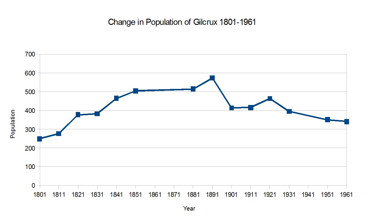
Census data shows the changes in the population of the parish over time. Censuses are recorded at 10-year intervals in the United Kingdom with the earliest records for population coming from the 1801 UK census. The graph in Figure 1 shows that the population increased steadily until 1891, after which it decreased slowly to its current figure.
]]
The increase in population is explained by John Marius Wilson in his Imperial Gazetteer of England and Wales, the increase in residents was due to the extensions of coal mines in the area.

Census data also reflects the social structure of the parish in 1831. The pie chart in Figure 2 shows the proportion of Gilcrux's workforce in very broad categories. Half of the total population worked as labourers and servants on the parish farms, and were most likely employed by those in the 'Employers and Professionals' group, which make up almost a quarter of the total population.
Governance
Gilcrux is part of the Penrith and Solway constituency of the UK parliament.
For Local Government purposes it is administered as part of the Cumberland unitary authority. Between 1974 and 2023 it was governed by Allerdale Borough Council and Cumbria County Council. Before 1974 it was part of Cockermouth Rural District.
The village also has its own Parish Council together with part of Bullgill; Gilcrux Parish Council.
Landmarks
The village contains St Mary's Church, which sits atop of a mound in the centre of the village. The church dates back to Norman times and was renovated in the late 13th century. The church has an Anglo-Danish Norse cross on its roof, and contains a glass altar screen of Leonardo da Vinci's painting of The Last Supper.
Building work started on the village hall in January 2010, and was completed in March 2012, costing £580,000, much of which came from National Lottery funding. The refurbishments included a glass entrance lobby, more meeting rooms, a bar area and improved toilet facilities.
The village also contains the Beeches Caravan Park; the village’s close proximity to the Lake District make it an attractive location for tourists, with the caravan park being open all year round.
Transport
By road, Gilcrux is close to two major roads, the A596 which is around 2 mi north of the village, and the A595 which is around 3.7 mi to the south. These two roads link the village with the town of Carlisle which is around 23 mi away.
A bus service is the only form of Public Transport in Gilcrux. The 39 bus is active on Tuesdays and Fridays and completes its route from Bothel to Carlisle once on these days
The nearest train station is Aspatria railway station which is roughly 3.4 mi away from Gilcrux. The station runs trains everyday northbound towards and southbound towards .
Demographics
According to the United Kingdom Census 2001 the population of the parish was 303, with the parish containing 119 households in total. reducing at the 2011 Census to a population of 299 in 132 households.
There are 145 people between the ages of 16 and 74 that are economically active, with 9 people in that age bracket unemployed and a further 66 economically inactive. Employment within the parish is split between the extractive and manufacturing industries, in which 41% of the population are employed, and the service industry, which employs the remaining 59% of the economically active employed population of Gilcrux. The census data also allows us to see the mean distance that the residents of Gilcrux have to travel to their place of employment, the figure given is 14.55 mi; this could suggest that few people remain in the parish to work and instead commute to large settlements each day for work.
Climate
Notable people
- Dr William Perry Briggs, Medical Officer of Health to Aspatria Urban District Council (1892–1928)
References
References
- "GEOnet Names Server (GNS)".
- "GENUKI:Gilcrux,Cumberland".
- "Bing Maps Directions".
- "Old Cumbria Gazetteer".
- "A Guide to the Place-Name Evidence".
- "Institute for Name-Studies Website".
- "A Vision of Britain Through Time".
- (May 2019). "A Vision of Britain Through Time".
- "A Vision of Britain through time, Gilcrux".
- "A Vision of Britain Through time, Gilcrux".
- "Gilcrux Parish Council".
- "The Cumbria Directory, Gilcrux".
- "Visit Cumbria".
- "Cumberland News, Gilcrux Village Hall".
- "News and Star, Gilcrux Village Hall".
- "Beeches Caravan Park".
- "Bing Maps".
- "Bing Maps".
- "Service 39".
- "Carlisle-Barrow Timetable".
- "Office for National Statistics Website".
- "Office for National Statistics Website".
- "Parish population 2011".
- "Office for National Statistics Website".
- (October 2017). "Weather in Gilcrux, wigton".
This article was imported from Wikipedia and is available under the Creative Commons Attribution-ShareAlike 4.0 License. Content has been adapted to SurfDoc format. Original contributors can be found on the article history page.
Ask Mako anything about Gilcrux — get instant answers, deeper analysis, and related topics.
Research with MakoFree with your Surf account
Create a free account to save articles, ask Mako questions, and organize your research.
Sign up freeThis content may have been generated or modified by AI. CloudSurf Software LLC is not responsible for the accuracy, completeness, or reliability of AI-generated content. Always verify important information from primary sources.
Report