From Surf Wiki (app.surf) — the open knowledge base
Fischer Nunatak
Nunatak in Mac. Robertson Land, Antarctica
Nunatak in Mac. Robertson Land, Antarctica
| Field | Value |
|---|---|
| map | Antarctica |
| elevation_m | 750 |
| coordinates | |
| coordinates_ref | |
| native_name | |
| native_name_lang | |
| location | Antarctica |
| country_type | Continent |
| country | |
| state_type | Region |
| state | Mac. Robertson Land |
| region | |
| district | |
| part | |
| settlement_type | Use settlement_type= instead of city_type= (deprecated). |
| settlement |
| volcanic_arc/belt =
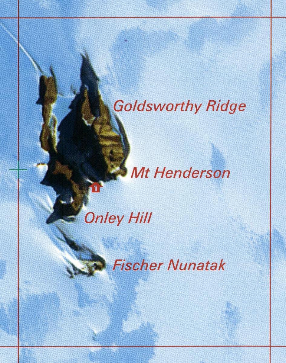
Fischer Nunatak () is a nunatak, 750 m high, standing 2 nmi south of Mount Henderson in the northeast part of the Framnes Mountains, Mac. Robertson Land, Antarctica.
Discovery
Fischer Nunatak was mapped by Norwegian cartographers from air photos taken by the Lars Christensen Expedition, 1936–37, and named "Sornuten" (the south peak). It was renamed by the Australian National Antarctic Research Expeditions (ANARE) for H.J.L. Fischer, cook at Mawson Station in 1958. In 1954 a barge caravan was used as a remote weather station on the nunatak. It was removed in 1989.
Appearance
Fischer Nunatak is about 1.5 km south of Mount Henderson, and has similar geology to Mount Henderson. It is about 750 m high, with an area of exposed rock that covers about 1 km2. There is a broad valley to the south of the nunatak. As of 1998 the ice surrounding the nunatak had many crevasses. The nunatak has a long, smooth slope that is ideal for downhill skiing during the rare periods when there is enough snow cover.
Plant life
A botanical survey of Fischer Nunatak Fischer Nunatak in 1962 by ANARE based at Mawson Station found eight species of lichen and one species of moss, Grimmia lawiana. The nunatak has very different lichen fauna from Mount Henderson. On the south side there is plentiful Biatorella antarctica. The west side has abundant Buellia lignoides and Rhizocarpon flavum, neither of which is found on Mount Henderson. A specimen of Umbilicaria decussata collected on the nunatak is preserved in the Royal Botanic Gardens Victoria.
References
Sources
- {{citation|url=https://pubs.usgs.gov/fedgov/70039167/report.pdf |accessdate=2023-11-07 |edition=2 |editor-last=Alberts |title=Geographic Names of the Antarctic |editor-first=Fred G.
- {{citation |url=https://www.antarctica.gov.au/site/assets/files/64898/ar_82.pdf |accessdate=2023-11-28
- {{citation |url=https://www.abc.net.au/science/antarctica/ingrid/diaries/981010.htm |accessdate=2023-11-28
- {{citation |url=https://www.anareclub.org/recipient-of-the-phillip-law-medal-2017-dave-mccormack/ |accessdate=2023-11-28
- {{citation |url=https://www.xnatmap.org/daat/docs/manningj/Anniversary.htm |accessdate=2023-11-28
- {{citation |url=https://avh.ala.org.au/occurrences/eff13508-8872-4bfc-b248-feef32559e4c |accessdate=2023-11-28 |ref=
This article was imported from Wikipedia and is available under the Creative Commons Attribution-ShareAlike 4.0 License. Content has been adapted to SurfDoc format. Original contributors can be found on the article history page.
Ask Mako anything about Fischer Nunatak — get instant answers, deeper analysis, and related topics.
Research with MakoFree with your Surf account
Create a free account to save articles, ask Mako questions, and organize your research.
Sign up freeThis content may have been generated or modified by AI. CloudSurf Software LLC is not responsible for the accuracy, completeness, or reliability of AI-generated content. Always verify important information from primary sources.
Report