From Surf Wiki (app.surf) — the open knowledge base
Falkland Sound
Sound between the Falkland Islands
Sound between the Falkland Islands
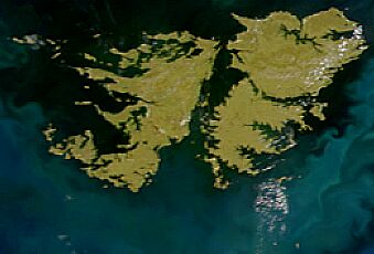
The Falkland Sound () is a sea strait in the Falkland Islands. Running southwest-northeast, it separates West and East Falkland.
Name
The sound was named by John Strong in 1690 for Viscount Falkland, the name only later being applied to the archipelago and its two largest islands. The Spanish name "Estrecho de San Carlos" refers to the ship San Carlos which visited in 1768; confusingly the English name "San Carlos Water" is a much smaller inlet on East Falkland - and gives its name to San Carlos, Port San Carlos and the San Carlos River.
Captain John Strong of the Welfare made the first recorded landing on either of the main islands (West and East Falkland) on 29 January 1690, at Bold Cove (near Port Howard) just off Falkland Sound.
Geography
The sound cuts between the two main islands in a northeast-southwest alignment, though minor islands within the body of water include Narrows Island, Great Island, the Tyssen Islands and the Swan Islands. Eddystone Rock is at the northern end of the Sound; the Arch Islands are at the southern end.
Settlements on it include Ajax Bay, New Haven, Port San Carlos, San Carlos on East Falkland and Port Howard and Fox Bay on West Falkland. A car ferry goes between Port Howard and New Haven.
Inlets and bays on the Sound include: Fox Bay, Port Howard (West Falkland); Grantham Sound, San Carlos Water, Ruggles Bay (East Falkland). On West Falkland, the Hornby Hills run parallel to the sound.
Geology


About 400 million years ago the land that became the Falkland Islands and Antarctica's Ellsworth Mountains, which had been part of Gondwana, broke from what is now Africa and drifted westwards relative to Africa.{{cite web |access-date=2010-06-05 |url-status=dead |archive-url=https://web.archive.org/web/20110720195504/http://www.epd.gov.fk/wp-content/uploads/Falkland%20Islands%20State%20of%20the%20Environment%20Report%202008_final_sm.pdf |archive-date=2011-07-20
It is believed that at times during the Pleistocene era, the seabed was some 46 m lower than the present time–sufficient for the sound to be bridged.{{cite report |access-date=17 May 2013 |url-status=dead |archive-url=https://web.archive.org/web/20130517213439/http://www.antarctica.ac.uk/documents/scientific_reports/rep009.zip |archive-date=17 May 2013
Records
On 21 January 2025, Esther Bertram of Stanley and Nuala Knight of Fox Bay swam across Falkland Sound, beginning from Fanning Head, East Falkland. The swimmers reached Jersey Point on West Falkland after 2 hours 37 minutes.
References
- Southby-Tailyour, Ewen - Falkland Island Shores
This article was imported from Wikipedia and is available under the Creative Commons Attribution-ShareAlike 4.0 License. Content has been adapted to SurfDoc format. Original contributors can be found on the article history page.
Ask Mako anything about Falkland Sound — get instant answers, deeper analysis, and related topics.
Research with MakoFree with your Surf account
Create a free account to save articles, ask Mako questions, and organize your research.
Sign up freeThis content may have been generated or modified by AI. CloudSurf Software LLC is not responsible for the accuracy, completeness, or reliability of AI-generated content. Always verify important information from primary sources.
Report