From Surf Wiki (app.surf) — the open knowledge base
Exclusive economic zone
Adjacent sea zone in which a state has special rights

Adjacent sea zone in which a state has special rights
An exclusive economic zone (EEZ), as prescribed by the 1982 United Nations Convention on the Law of the Sea, is an area of the sea in which a sovereign state has exclusive rights regarding the exploration and use of marine resources, including energy production from water and wind.
It stretches from the outer limit of the territorial sea (22.224 kilometres or 12 nautical miles from the baseline) out 370.4 kilometres (or 200 nautical miles) from the coast of the state in question. It is also referred to as a maritime continental margin and, in colloquial usage, may include the continental shelf. The term does not include either the territorial sea or the continental shelf beyond the 200 nautical mile limit. The difference between the territorial sea and the exclusive economic zone is that the first confers full sovereignty over the waters, whereas the second is merely a "sovereign right" which refers to the coastal state's rights below the surface of the sea. The surface waters are international waters.
Definition

Generally, a state's exclusive economic zone is an area beyond and adjacent to the territorial sea, extending seaward to a distance of no more than 200 nmi out from its coastal baseline. The exception to this rule occurs when exclusive economic zones would overlap; that is, state coastal baselines are less than 400 nmi apart. When an overlap occurs, it is up to the states to delineate the actual maritime boundary. Generally, any point within an overlapping area defaults to the nearest state.
The exclusive economic zone stretches much further into sea than the territorial waters, which end at 12 nmi from the coastal baseline (if following the rules set out in the United Nations Convention on the Law of the Sea). Thus, the exclusive economic zones includes the contiguous zone.
States also have rights to the seabed of what is called the extended continental shelf up to 350 nmi from the coastal baseline, beyond the exclusive economic zones, but such areas are not part of their exclusive economic zones.
The legal definition of the continental shelf does not correspond exactly to the geological meaning of the term, as it also includes the continental rise and slope, and the entire seabed within the exclusive economic zone.
Origin and history
The idea of allotting nations' EEZs to give them more control of maritime affairs outside territorial limits gained acceptance in the late 20th century.
Initially, a country's sovereign territorial waters extended 3 nmi (range of cannon shot) beyond the shore. In modern times, a country's sovereign territorial waters extend to 12 nmi beyond the shore. One of the first assertions of exclusive jurisdiction beyond the traditional territorial seas was made by the United States in the Truman Proclamation of 28 September 1945. However, it was Chile and Peru respectively that first claimed maritime zones of 200 nautical miles with the Presidential Declaration Concerning Continental Shelf signed by Chilean President Gabriel Gonzalez Videla on 23 June 1947 and by Peruvian President Jose Luis Bustamante y Rivero through Presidential Decree No. 781 of 1 August 1947
It was not until 1982 with the UN Convention on the Law of the Sea that the 200 nautical mile exclusive economic zone was formally adopted.
Disputes
The exact extent of exclusive economic zones is a common source of conflicts between states over marine waters.
Unresolved
Arctic Ocean
- A wedge-shaped section of the Beaufort Sea, an area that reportedly contains substantial oil reserves, is disputed between Canada and the United States.
Atlantic Ocean
- Several countries (Denmark, Iceland, Ireland, and the United Kingdom) have competing claims to the continental shelf near Rockall, an uninhabitable rock located in the EEZ of the United Kingdom. In addition, since Brexit the United Kingdom has claimed a 12 nmi exclusion zone around Rockall, which Ireland does not recognise.
Caribbean Sea
- In 1996, the Dominican Republic and United Kingdom signed an agreement establishing a simplified equidistance boundary between the British Overseas Territory of Turks and Caicos and the Dominican Republic. Mouchoir Bank fell on the Turks and Caicos side of the boundary, and Silver and Navidad Banks on the Dominican Republic side. However, the agreement was not subsequently ratified by either party. Instead, the Dominican Republic declared itself an archipelagic state in 2007, claiming sovereignty over Mouchoir Bank and extending its EEZ beyond the boundary agreement with the United Kingdom. The United Kingdom does not accept the archipelagic status and maritime boundaries claimed by the Dominican Republic.
- Since 2007, the Dominican Republic in Hispaniola considers itself an archipelagic state, encroaching the long-established median or equidistance line dividing the EEZ of the Dominican Republic and Puerto Rico, and claiming portion of the EEZ claimed by the United States in relation to the archipelago of Puerto Rico, itself an unincorporated U.S. territory. The United States does not accept the archipelagic status and maritime boundaries claimed by the Dominican Republic. Victor Prescott, an authority in the field of maritime boundaries, argued that, as the coasts of both states are short coastlines with few offshore islands, an equidistance line is appropriate.
Indian Ocean
- Mauritius claims an EEZ for Tromelin Island from France and an EEZ in respect of the British Indian Ocean Territory from the UK. An Exclusive Economic Zone covering 2.3 million square kilometres is claimed by Mauritius.
Mediterranean Sea
- Croatia's ZERP (Ecological and Fisheries Protection Zone) in the Adriatic Sea caused friction with Italy and Slovenia, and caused problems during the accession of Croatia to the European Union.
- Turkey claims a portion of Cyprus's claimed EEZ based on Turkey's definition that no islands, including Cyprus, can have a full EEZ and should only be entitled to 12 nautical miles. Furthermore, the Turkish Republic of Northern Cyprus (TRNC), only recognized by Turkey, also claims portions of Cyprus's claimed EEZ. Turkey also disputes Greece's EEZ for the same reason in regards to its islands in the Aegean Sea. Turkey is one of few countries to not have signed UNCLOS.
- Greece claims that the maritime deal between the internationally recognized GNA government of Libya and Turkey is illegal and it signed a counter agreement with Egypt.
- Lebanon claims that the agreement between Cyprus and Israel overlapped its own EEZ.
Pacific Ocean
- The South China Sea is the setting for several ongoing disputes between regional powers including China, Taiwan, Vietnam, the Philippines, Indonesia, Malaysia and Brunei.
- Japan claims an EEZ around Okinotorishima, but this is disputed by China, Taiwan, and South Korea, who claim it is an islet which is incapable of generating an EEZ.
- China and South Korea debates over the boundaries of EEZs in the East China Sea and Yellow Sea, including Socotra Rock, a source for territorial dispute.
Potential
Regions where a permanent ice shelf extends beyond the coastline are also a source of potential dispute.
Resolved
- The Cod Wars between the United Kingdom and Iceland occurred periodically over many decades until they were resolved with a final agreement in 1976.
- In 1992, the Canada–France Maritime Boundary Case, which centred on the EEZ around the French islands of Saint Pierre and Miquelon, was decided by an arbitral tribunal that concurred on the whole with the arguments put forth by Canada. France was awarded 18% of the area it had originally claimed.
- In 1999, following the Hanish Islands conflict, the Permanent Court of Arbitration ruled that the EEZs of Yemen and Eritrea should be demarcated equidistantly between the mainlands of the two nations, without taking account of sovereignty over the islands.
- In 2009, in a dispute between Romania and Ukraine over Snake Island, the UN International Court of Justice decided that Snake Island has no EEZ beyond 12 nautical miles of its own land.
- In 2010, a dispute between Norway and Russia about both territorial waters and EEZ with regard to the Svalbard archipelago as it affects Russia's EEZ due to its unique treaty status was resolved. A treaty was agreed in principle in April 2010 between the two states and subsequently officially ratified, resolving this demarcation dispute. The agreement was signed in Murmansk on 15 September 2010.
- In 2014, the Netherlands and Germany resolved an old border dispute regarding the exact location of the border in the Dollart Bay.
Transboundary stocks
Fisheries management, usually adhering to guidelines set by the Food and Agriculture Organization (FAO), provides significant practical mechanisms for the control of EEZs. Transboundary fish stocks are an important concept in this control. Transboundary stocks are fish stocks that range in the EEZs of at least two countries. Straddling stocks, on the other hand, range both within an EEZ as well as in the high seas, outside any EEZ. A stock can be both transboundary and straddling.
By region or country
Region
Caribbean Sea

Atlantic and Indian Oceans
Pacific Ocean

Country
Algeria
Algeria on 17 April 2018 established an exclusive economic zone (EEZ) off its coasts by Presidential Decree No. 18-96 of 2 Rajab 1439 corresponding to 20 March 2018. The permanent mission of Spain to the United Nations on 27 July 2018 declared its disagreement with the EEZ announced by Algeria and that the government of Spain indicated its willingness to enter into negotiations with the government of Algeria with a view to reaching a mutually acceptable agreement on the outer limits of their respective exclusive economic zones, The same was done by the Italian mission on 28 November 2018. The two countries indicated that the Algerian measure had been taken unilaterally and without consulting them.
On 25 November 2018, the Algerian Ministry of Foreign Affairs sent an oral note in response to the Spanish protest, explaining that the Algerian government does not recognize the largely exorbitant coordinates contained in Royal Decree 236/2013, which overlap with the coordinates of Presidential Decree n° 18–96 establishing an exclusive economic zone off the coast of Algeria. The Algerian government wished to emphasize that the unilateral delimitation carried out by Spain is not in conformity with the letter of the United Nations Convention on the Law of the Sea and has not taken into consideration the configuration, the specific characteristics, and the special circumstances of the Mediterranean Sea, in particular for the case of the two countries whose coasts are located face to face, as well as the objective rules and relevant principles of international law to govern the equitable delimitation of the maritime areas between Algeria and Spain, in accordance with article 74 of the United Nations Convention on the Law of the Sea. Algeria expressed its willingness to negotiate for a just solution.
On 20 June 2019, a communication from Algeria was sent. It was addressed to the Italian embassy and the Spanish embassy in Algiers to show their eligibility in Algeria's exclusive economic zone.
Argentina
Considering the maritime areas claimed, the total area of Argentina reaches 3,849,756 km2. The recognized Argentine EEZ area is 1,159,063 km2.
Australia
Main article: Exclusive economic zone of Australia

Australia's exclusive economic zone was declared on 1 August 1994, and extends from 12 to 200 nautical miles from the coastline of Australia and its external territories, except where a maritime delimitation agreement exists with another state. To the 12 nautical miles boundary is Australia's territorial waters. Australia has the third largest exclusive economic zone, behind France and the United States, but ahead of Russia, with a total area of 8,148,250 square kilometres, which actually exceeds its land territory.
The United Nations Commission on the Limits of the Continental Shelf (CLCS) confirmed, in April 2008, Australia's rights over an additional 2.5 million square kilometres of seabed beyond the limits of Australia's EEZ. Australia also claimed, in its submission to the UN Commission on the Limits of the Continental Shelf, additional Continental Shelf past its EEZ from the Australian Antarctic Territory, but these claims were deferred on Australia's request. However, Australia's EEZ from its Antarctic Territory is approximately 2 million square kilometres.
| Region | website=Geoscience Australia | url=http://www.ga.gov.au/scientific-topics/national-location-information/dimensions/oceans-and-seas | title=Oceans and Seas | date=15 May 2014 | publisher=Australian Government | access-date=22 May 2020}} |
|---|---|---|---|---|---|---|
| Mainland Australia (5 States and 3 Territories of the Australian Federation), Tasmania, and other minor islands | 6,048,681 | |||||
| Macquarie Island | 471,837 | |||||
| Christmas Island | 463,371 | |||||
| Norfolk Island | 428,618 | |||||
| Heard Island and McDonald Islands | 410,722 | |||||
| Cocos Islands | 325,021 | |||||
| *Australian Antarctic Territory* | *2,000,000* | |||||
| **Total** | **8,148,250** |
Brazil
Main article: Exclusive economic zone of Brazil

Brazil's EEZ includes areas around the Fernando de Noronha Islands, Saint Peter and Saint Paul Archipelago, and the Trindade and Martim Vaz Islands.
| Region | EEZ Area (km2) | |
|---|---|---|
| Brazil Mainland Brazil (9 States of the Brazilian Federation) | 2,570,917 | |
| Espírito Santo Trindade and Martim Vaz Islands | 468,599 | |
| Pernambuco Saint Peter and Saint Paul Archipelago | 413,636 | |
| [[File:Flag of Fernando de Noronha.svg | 22px]] Fernando de Noronha Islands | 363,362 |
| **Total** | **3,830,955 ** |
Canada
Main article: Exclusive economic zone of Canada

Canada is unusual in that its exclusive economic zone, covering 5,599,077 km2, is slightly smaller than its territorial waters. The latter generally extend only 12 nautical miles from the shore but also include inland marine waters such as Hudson Bay (about 300 nmi across), the Gulf of Saint Lawrence and the internal waters of the Arctic Archipelago.
Chile

Chile's EEZ includes areas around the Desventuradas Islands, Easter Island, and the Juan Fernández Islands.
| Region | EEZ Area (km2) | Land Area (km2) | Total |
|---|---|---|---|
| Mainland Chile | 1,987,371 | 755,757 | 2,743,128 |
| Easter Island | 720,412 | 164 | 720,576 |
| Juan Fernández Islands | 502,524 | 100 | 502,624 |
| Desventuradas Islands | 449,836 | 5 | 449,841 |
| **Total** | **3,660,143** | **756,102.4** | **4,416,245.4** |
In 2020 and 2022, Chile submitted its partial claims to the United Nations Commission on the Limits of the Continental Shelf (CLCS) to extend its maritime continental margin.
China

Total: 2,236,430 km2]]
The first figure excludes all disputed waters, while the last figure indicates China's claimed boundaries, and does not take into account adjacent powers' claims.
Croatia
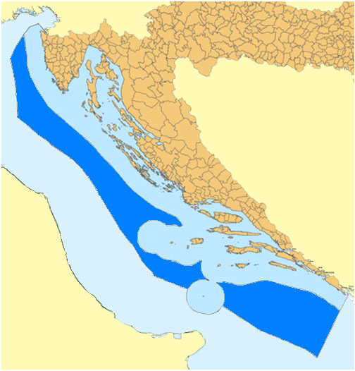
Croatia proclaimed Ecological and Fisheries Protection Zone in 2003, but it was not enforced toward other European Union states especially Italy and Slovenia. The zone was upgraded to EEZ in 2021 together with Italy and Slovenia. Territorial waters has 18,981 km2, while internal waters located within the baseline cover an additional 12,498 km2, and EEZ covers 24,482 km2 for a total of 55,961 km2.
Cyprus
Cyprus EEZ covers 98,707 square km (38,100 square miles). Cyprus' EEZ borders those of Greece, Turkey, Syria, Lebanon, Israel and Egypt.
Denmark

The Kingdom of Denmark includes the constituent country (selvstyre) of Greenland and the constituent country (hjemmestyre) of the Faroe Islands.
| Region | EEZ & TW Area (km2) | Land area | Total |
|---|---|---|---|
| Denmark | 105 989 | 42 506 | 149 083 |
| Faroe Islands | 260 995 | 1 399 | 262 394 |
| Greenland | 2,184,254 | 2,166,086 | 4,350,340 |
| **Total** | **2,551,238** | **2,210,579** | **4,761,817** |
Ecuador

Area: 1,077,231 km2
France
Main article: Exclusive economic zone of France

Due to its numerous overseas departments and territories scattered on all oceans of the planet, France possesses the largest EEZ in the world, covering 11,691,000 km2. The EEZ of France covers approximately 7% of the total surface of all the EEZs of the world, whereas the land area of the French Republic is only 0.45% of the total land area of Earth.
Germany
Main article: Exclusive economic zone of Germany
Germany declared the establishment of its exclusive economic zone in the North and Baltic Seas on 1 January 1995. The relevant German legal provisions that are applicable within the EEZ include the Maritime Task Act (Seeaufgabengesetz) from 1965, the Maritime Facilities Act (Seeanlagengesetz) from 2017, and prior to that the Sea Facilities Ordinance (Seeanlagenverordnung) from 1997, the Federal Mining Act (Bundesberggesetz) and the Regional Planning Act (Raumordnungsgesetz).
The German EEZ has an area of 32,982 km2. About 70% of the EEZ covers Germany's entire North Sea area, while some 29% encompasses the Baltic Sea area.
Greece
Main article: Exclusive economic zone of Greece
thumb|upright=1.35|Exclusive Economic Zone of Greece
Greece forms the southernmost part of the Balkan peninsula in the Mediterranean Sea. It includes many small islands which vary between 1,200 and 6,000 in the Aegean Sea and the Ionian Sea. The largest islands are Crete, Euboea, Lesbos, Rhodes and Chios.
Greece's EEZ is bordered to the west by Albania and Italy, to the south by Libya and Egypt, and to the east by Cyprus and Turkey.
| Territory | km2 | sq mi | Notes | Total | 505,572 | 195,202 |
|---|
India
Main article: Exclusive economic zone of India
| EEZ | Area (km2) |
|---|---|
| Mainland India (9 states and 2 union territories) and Lakshadweep union territory | 1,641,514 km2 |
| Andaman and Nicobar Islands union territory | 663,629 km2 |
| Total | 2,305,143 km2 |
India is currently seeking to extend its EEZ to 350 miles.
Indonesia
Main article: Exclusive economic zone of Indonesia
Indonesia has the 6th largest exclusive economic zone in the world. The total size is 6159032 km2. It claims an EEZ of 200 nautical miles from its shores. This is due to the 13,466 islands of the Indonesian Archipelago. It has the 2nd largest coastline of 54,720 km (34,000 mi). The five main islands are: Sumatra, Java, Borneo, Sulawesi, and Western New Guinea. There are two major island groups (Nusa Tenggara and the Maluku Islands) and sixty smaller island groups.
Ireland
Since independence, Ireland's territorial waters were limited to 3 nmi. In 1964, her territorial waters were extended to 12 nmi from the baseline covering an area of 41000 km2, although several European countries retained fishing rights between 6 -. In 1976, Ireland's exclusive economic zone was extended out to 200 nmi, increasing her maritime area to 450000 km2. In 1996, Ireland ratified the United Nations Convention on the Law of the Sea (UNCLOS) which allows her to claim the continental shelf out to 350 nmi from the baseline. Ireland has made claims under UNCLOS for the Porcupine Abyssal Plain in 2005, the seabed of the Celtic Sea and Bay of Biscay in 2006, and also the Hatton Rockall area in 2009. She was awarded the Porcupine Abyssal claim in 2007 adding 39000 km2 of seabed to the State's continental shelf. The other two claims are still under discussion with neighbouring states; the Celtic Sea and Bay of Biscay with France, Spain and the United Kingdom; and the Hatton Rockall area with Denmark, Iceland and the United Kingdom. In 2006, Ireland claimed her contiguous zone out to 24 nmi from the baseline.
Israel
In 2010, an agreement was signed with Cyprus concerning the limit of territorial waters between Israel and Cyprus at the maritime halfway point, a clarification essential for safeguarding Israel's rights to oil and underwater gas reservoirs. The agreement was signed in Nicosia by Israeli Infrastructure Minister Uzi Landau and the Cypriot Foreign Minister Markos Kyprianou. The two countries agreed to cooperate in the development of any cross-border resources discovered and to negotiate an agreement on dividing joint resources.
Italy
Main article: Exclusive economic zone of Italy
.png)
Italy has an EEZ of 541915 km2. The country claims an EEZ of 200 nautical miles from its shores, and its three coastlines are the Tyrrhenian Sea to the west, the Ionian Sea to the south and the Adriatic Sea to the east. Italy's EEZ is limited by maritime boundaries with neighboring countries to the northwest, east and southeast.
Italy's western sea territory stretches from the west coast of Italy on the Tyrrhenian Sea, including the island of Sardinia. The island of Sicily is in the southernmost area. Lampedusa, a tiny island in the Mediterranean Sea, is the country's southernmost point. Italy shares treaty-defined maritime boundaries with France, Spain, Algeria, Tunisia, Libya, Malta, Greece, Albania, Montenegro, Croatia and Slovenia.
Japan
Main article: Exclusive economic zone of Japan
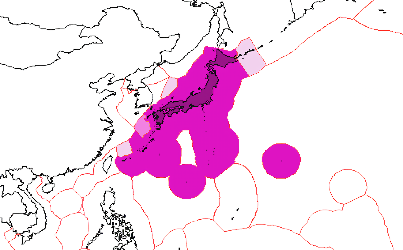
Japan has the world's eighth-largest exclusive economic zone, covering 4,479,674 km2. It claims an EEZ of 200 nautical miles from its shores.
| Region | EEZ Area (km2) | EEZ Area (sq mi) | Total | 4,479,674 | 1,729,612 |
|---|---|---|---|---|---|
| Ryukyu Islands | 1,394,676 sqkm | ||||
| Pacific Ocean (Japan) | 1,162,334 sqkm | ||||
| Nanpō Islands | 862,782 sqkm | ||||
| Sea of Japan | 630,721 sqkm | ||||
| Minami-Tori-shima | 428,875 sqkm | ||||
| Sea of Okhotsk | 235 sqkm | ||||
| Daitō Islands | 44 sqkm | ||||
| *Senkaku Islands* | 7 sqkm |
Japan has disputes over its EEZ boundaries with all its Asian neighbors (China, Russia, South Korea, and Taiwan). The above, and relevant maps at the Sea Around Us Project both indicate Japan's claimed boundaries, and do not take into account the claims of adjacent jurisdictions.
Japan also refers to various categories of "shipping area" – Smooth Water Area, Coasting Area, Major or Greater Coasting Area, Ocean Going Area – but it is unclear whether these are intended to have any territorial or economic implications.
Malaysia
Main article: Exclusive economic zone of Malaysia
Mexico
Main article: Exclusive economic zone of Mexico

Mexico's exclusive economic zones cover a total surface area of 3,269,386 km2, and places Mexico among the countries with the largest areas in the world.
Myanmar
Main article: Exclusive economic zone of Myanmar
New Zealand
Main article: Exclusive economic zone of New Zealand
New Zealand's EEZ covers 4,083,744 km2, which is approximately fifteen times the land area of the country. Sources vary significantly on the size of New Zealand's EEZ; for example, a recent government publication gave the area as roughly 4,300,000 km2. These figures are for the EEZ of New Zealand proper, and do not include the EEZs of other territories in the Realm of New Zealand (the Cook Islands, Niue, Tokelau, and the Ross Dependency).
North Korea
Main article: Exclusive economic zone of North Korea

The exclusive economic zone of North Korea stretches 200 nautical miles from its basepoints in both the West Sea (Yellow Sea) and the Sea of Japan. The EEZ was declared in 1977 after North Korea had contested the validity of the Northern Limit Lines (NLL) set up after the Korean War as maritime borders. The EEZ has not been codified in law and North Korea has never specified its coordinates, making it difficult to determine its specific scope.
In the West Sea, the EEZ remains unspecified in the Korea Bay because China has not determined its own EEZ in the area. The border between the North Korean and South Korean EEZs in the West Sea cannot be determined because of potential overlap and disputes over certain islands.
In the Sea of Japan, the North Korean EEZ can be approximated to be trapezoidal-shaped. The border between North Korea and Russia's respective EEZs is the only such border that has been determined in East Asia. Here, the EEZ does not cause many problems, even with regards to South Korea, because the sea is not thought to be rich in resources.
Norway
The Kingdom of Norway has a large exclusive economic zone of 819,620 km2 around its coast. The country has a fishing zone of 1,878,953 km2, including fishing zones around Svalbard and Jan Mayen.
In April 2009, the United Nations Commission for the Limits of the Continental Shelf approved Norway's claim to an additional 235,000 square kilometres of continental shelf. The commission found that Norway and Russia both had valid claims over a portion of the shelf in the Barents Sea.
| Region | EEZ and Territorial | ||
|---|---|---|---|
| Waters Area (km2) | Land Area (km2) | Total (km2) | |
| Mainland Norway | 1,273,482 | 323,802 | 1,597,284 |
| Svalbard | 402,574 | 61,002 | 463,576 |
| Jan Mayen | 273,118 | 373 | 273,491 |
| Bouvet Island | 436,004 | 49 | 436,053 |
| **Total** | **2,385,178** | **385,226** | **2,770,404** |
Pakistan
Main article: Exclusive economic zone of Pakistan
Area: 290000 sqkm
The coast of Pakistan is 1046 km long, extending from Sir Creek in the east to Gwatar Bay in the west and the EEZ extends up to 290000 sqkm which is equivalent to more than 30% of its land area and ranks sixty-sixth in the world by area.
Pakistan had an EEZ of 240000 sqkm before their case was accepted by UNCLCS. Pakistan Navy with the help of the National Oceanographic Organization (NIO) initiated the continental shelf case at ministerial level in 1995.
On 26 Aug 2013, a seven-member sub-commission with members from Japan, China, Mozambique, Kenya, Denmark, Georgia and Argentina was formulated at UNCLCS to evaluate the technical details of Pakistan's case and after a year accepted Pakistan's claim.
On 13 March 2015, UN Commission on the Limits of Continental Shelf (UNCLCS) accepted recommendations for extension of the outer limits of the continental shelf on Pakistan's case so far 80 countries had submitted claims to UNCLCS out of which recommendations of 22 countries including Pakistan had been finalised.
It was a historic event in the country's history when Pakistan became the first country in the region to have its continental shelf extended to 350 nm.
Some of the claimed territories overlapped the Omani claim. It is believed that the verdict in favour of Pakistan was announced after successful negotiation with Oman.
Peru

Area: 857,000 km2
Philippines
Main article: Exclusive economic zone of the Philippines
The Philippines' EEZ covers 2,263,816 km2.
Poland
Main article: Exclusive economic zone of Poland
The Polish EEZ covers the area of 30533 km2 within the Baltic Sea.
Portugal
Main article: Exclusive economic zone of Portugal
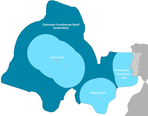
Portugal has the 20th largest EEZ in the world. Presently, it is divided in three non-contiguous sub-zones:
- Continental Portugal 327,667 km2
- Azores 953,633 km2
- Madeira 446,108 km2
- Total : 1,727,408 km2 Portugal submitted a claim to extend its jurisdiction over an additional 2.15 million square kilometres of the adjacent continental shelf in May 2009, resulting in an area with a total of more than 3,877,408 km2. The submission, as well as a detailed map, can be found in the Task Group for the extension of the Continental Shelf website.
Spain previously objected to the EEZ's southern border, maintaining that it should be drawn halfway between Madeira and the Canary Islands. But Portugal exercises sovereignty over the Savage Islands, a small archipelago north of the Canaries, claiming an EEZ border further south. Spain has no longer disputed the Portuguese claim since 2015.
Romania
Area: 23,627 km2
Russia

Main article: Exclusive economic zone of Russia
Russia's exclusive economic zone, the world's fourth largest, is composed of:
- Kaliningrad (Baltic Sea) – 11,634 km2
- Saint Petersburg (Baltic Sea) – 12,759 km2
- Barents Sea – 1,308,140 km2
- Black Sea (without the Crimean EEZ) – 66,854 km2
- Pacific – 3,419,202 km2
- Siberia – 3,277,292 km2
- Total – 8,095,881 km2
Senegal
Area: 158,861 km2
Somalia
Main article: Exclusive economic zone of Somalia
Area: 825,052 km2
South Africa

South Africa's EEZ includes both that next to the African mainland and that around the Prince Edward Islands, totalling 1,535,538 km2.
- Mainland – 1,068,659 km2
- Prince Edward islands – 466,879 km2
South Korea

Area: 300,851 (225,214) km2
Spain
Main article: Exclusive economic zone of Spain

Area: 1,039,233 km2
Sri Lanka
Main article: Exclusive economic zone of Sri Lanka
Thailand
Main article: Exclusive economic zone of Thailand

Area: 299,397 km2
Turkey
Turkey's EEZ is bordered by Georgia, Russia, Ukraine, Romania and Bulgaria in the Black Sea to the north, Greece in the Aegean Sea to the west, and Cyprus and Syria in the Mediterranean Sea to the south. Turkey is one of the few countries to not have signed UNCLOS and disputes Greece's and Cyprus' EEZ.
United Kingdom
Main article: Exclusive economic zone of the United Kingdom


The United Kingdom has the world's fifth-largest exclusive economic zone of 6805586 km2 square km. It comprises the EEZs surrounding the United Kingdom, the Crown Dependencies, and the British Overseas Territories. The figure does not include the EEZ of the British Antarctic Territory.
The EEZ associated with the Falkland Islands and South Georgia are disputed by Argentina. The EEZ of the Chagos Archipelago, also known as the British Indian Ocean Territory, is also disputed with Mauritius which considers the archipelago as a part of its territory. And the EEZ around Gibraltar is disputed by Spain, which claims the territory.
| Territory | EEZ Area (km2) | EEZ Area (sq mi) | Notes | Total | 6,805,586 | 2,627,651 |
|---|---|---|---|---|---|---|
| South Georgia and the South Sandwich Islands | 1449532 sqkm | Disputed with Argentina. | ||||
| Pitcairn Islands | 836108 sqkm | |||||
| United Kingdom | 773676 sqkm | Including the Isle of Man. | ||||
| Tristan da Cunha† | 754720 sqkm | Including Tristan da Cunha Gough Island. | ||||
| British Indian Ocean Territory | 638568 sqkm | Disputed with Mauritius. | ||||
| Falkland Islands | 550872 sqkm | Disputed with Argentina. | ||||
| Bermuda | 450370 sqkm | |||||
| Saint Helena† | 444916 sqkm | |||||
| Ascension Island† | 441658 sqkm | |||||
| Turks and Caicos Islands | 154068 sqkm | |||||
| Cayman Islands | 119137 sqkm | |||||
| Anguilla | 92178 sqkm | |||||
| British Virgin Islands | 80117 sqkm | |||||
| United Kingdom Channel Islands | 11658 sqkm | Including Bailiwick of Guernsey and Jersey. | ||||
| Montserrat | 7582 sqkm | |||||
| Gibraltar | 426 sqkm | Disputed with Spain. | ||||
| Akrotiri and Dhekelia | 0 sqkm | No EEZ area. The relevant EEZ areas around Cyprus Island are claimed by the Cyprus and Northern Cyprus. |
† A part of the overseas territory of Saint Helena, Ascension and Tristan da Cunha, which together has an EEZ of 1,641,294 square km.
United States
Main article: Exclusive economic zone of the United States

The United States' exclusive economic zone is the second-largest in the world, covering 11,351,000 km2. Areas of its EEZ are located in three oceans as well as the Gulf of Mexico, and the Caribbean Sea. Only France, with its widespread administrative departments and overseas territories in the North Atlantic, the Caribbean, the Indian Ocean, and in extensive island chains of the Pacific, has a larger EEZ than the United States.
| Territory | EEZ Area (km2) | EEZ Area (sq mi) | Notes | Total | 11,351,000 | 4,383,000 |
|---|---|---|---|---|---|---|
| Alaska | 3770021 sqkm | A non-contiguous state in the northwest extremity of the North American continent. | ||||
| Hawaii – Northwestern Islands | 1579538 sqkm | Including Midway Atoll, these islands form the Leeward Islands of the Hawaiian island chain. | ||||
| United States U.S. East Coast | 915763 sqkm | The mainland coastal states of the Eastern United States. As a region, this term most often refers to the coastal states of Maine, New Hampshire, Massachusetts, Rhode Island, Connecticut, New York, New Jersey, Delaware, Maryland, Virginia, North Carolina, South Carolina, Georgia, and the Atlantic Coast of Florida. | ||||
| Hawaii – Southeastern Islands | 895346 sqkm | These islands form the Windward Islands of the Hawaiian island chain. | ||||
| United States U.S. West Coast | 825549 sqkm | The mainland coastal states of the Western United States. As a region, this term most often refers to the coastal states of California, Oregon, Washington. | ||||
| Northern Mariana Islands | 749268 sqkm | An organized, unincorporated, Commonwealth of the United States. | ||||
| United States U.S. Gulf Coast | 707832 sqkm | The mainland coastal states of the Southern United States. As a region, this term most often refers to the coastal states of Texas, Louisiana, Mississippi, Alabama, and the Gulf Coast of Florida | ||||
| Johnston Atoll | 442635 sqkm | A National Wildlife Refuge in the U.S. Minor Outlying Islands. | ||||
| United States Howland and Baker Islands | 434921 sqkm | Both territories are National Wildlife Refuges in the U.S. Minor Outlying Islands. | ||||
| Wake Island | 407241 sqkm | A National Wildlife Refuge in the U.S. Minor Outlying Islands. | ||||
| American Samoa | 404391 sqkm | The only inhabited, unorganized, unincorporated, territory of the United States. | ||||
| Palmyra Atoll and Kingman Reef | 352300 sqkm | Both territories are National Wildlife Refuges in the U.S. Minor Outlying Islands. | ||||
| Jarvis Island | 316665 sqkm | A National Wildlife Refuge in the U.S. Minor Outlying Islands. | ||||
| Guam | 221504 sqkm | An organized, unincorporated, territory of the United States. | ||||
| Puerto Rico | 177685 sqkm | An organized, unincorporated, Commonwealth of the United States. | ||||
| U.S. Virgin Islands | 33744 sqkm | An organized, unincorporated, territory of the United States. | ||||
| Navassa Island | N/A | N/A | A National Wildlife Refuge in the U.S. Minor Outlying Islands. |
Note, the totals in the table actually add up to 12,234,403 square km and 4,723,705 square miles.
Vietnam
Main article: Exclusive economic zone of Vietnam, Territorial disputes in the South China Sea
Vietnam claims an exclusive economic zone (EEZ) of 1,395,096 km² with 200 nautical miles from its shores. These figures do not include the claimed EEZ areas of the Paracel Islands and the Spratly Islands. Vietnam has disputes mainly with the People's Republic of China due to the nine-dash line.
Countries with the most distant EEZs
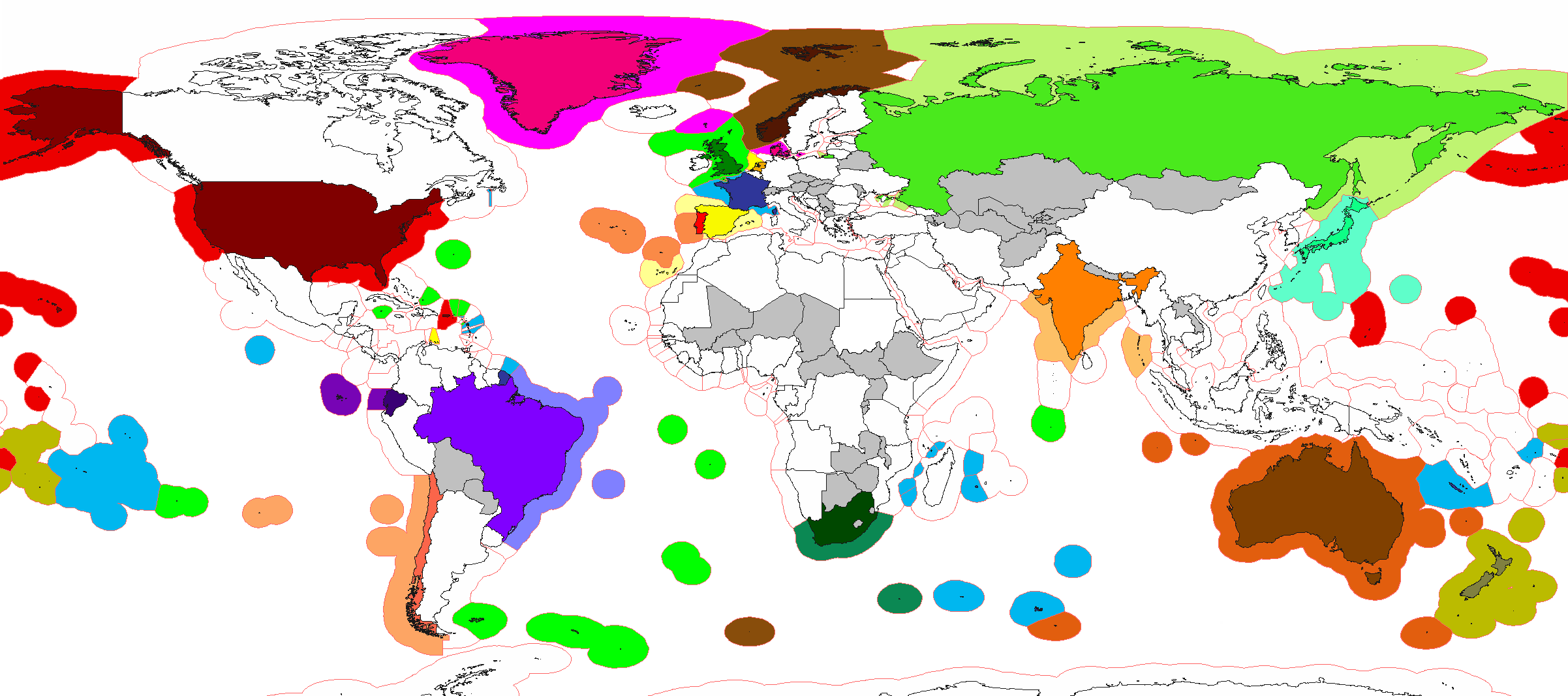
Rankings by area
Rankings by area
| Rank | Country | EEZ (km2) | Shelf (km2) | EEZ+TIA (km2) |
|---|---|---|---|---|
| 1 | France | 11,691,000 | 579,422 | 12,366,417 |
| 2 | United States | 11,351,000 | 2,193,526 | 21,814,306 |
| 3 | Australia | 8,505,348 | 2,194,008 | 16,197,464 |
| 4 | Russia | 7,566,673 | 3,817,843 | 24,664,915 |
| 5 | United Kingdom | 6,805,586 | 872,891 | 7,048,486 |
| 6 | Indonesia | 6,159,032 | 2,039,381 | 8,063,601 |
| 7 | Canada | 5,599,077 | 2,644,795 | 15,607,077 |
| 8 | Japan | 4,479,388 | 400,000 | 4,879,388 |
| 9 | New Zealand | 4,420,565 | 272,898 | 4,688,285 |
| 10 | Brazil | 3,830,955 | 2,005,179 | 12,346,722 |
| 11 | Chile | 3,681,989 | 252,947 | 4,431,381 |
| 12 | Kiribati | 3,441,810 | 7,523 | 3,442,536 |
| 13 | Mexico | 3,269,386 | 419,102 | 5,141,968 |
| 14 | Micronesia | 2,996,419 | 19,403 | 2,997,121 |
| 15 | Denmark | 2,551,238 | 495,657 | 4,761,811 |
| 16 | Papua New Guinea | 2,402,288 | 191,256 | 2,865,128 |
| 17 | Norway | 2,385,178 | 434,020 | 2,770,404 |
| 18 | India | 2,305,143 | 402,996 | 5,592,406 |
| 19 | Marshall Islands | 1,990,530 | 18,411 | 1,990,711 |
| 20 | *Cook Islands* | 1,960,027 | 1,213 | 1,960,267 |
| 21 | Portugal | 1,727,408 | 28,000 | 1,819,498 |
| 22 | Philippines | 1,590,780 | 272,921 | 1,890,780 |
| 23 | Solomon Islands | 1,589,477 | 36,282 | 1,618,373 |
| 24 | South Africa | 1,535,538 | 156,337 | 2,756,575 |
| 25 | Seychelles | 1,336,559 | 39,063 | 1,337,014 |
| 26 | Mauritius | 1,284,997 | 29,061 | 1,287,037 |
| 27 | Fiji | 1,282,978 | 47,705 | 1,301,250 |
| 28 | Madagascar | 1,225,259 | 101,505 | 1,812,300 |
| 29 | Argentina | 1,159,063 | 856,346 | 3,939,463 |
| 30 | Ecuador | 1,077,231 | 41,034 | 1,333,600 |
| 31 | Spain | 1,039,233 | 77,920 | 1,545,225 |
| 32 | Maldives | 923,322 | 34,538 | 923,622 |
| 33 | Peru | 906,454 | 82,000 | 2,191,670 |
| 34 | China | 877,019 | 231,340 | 10,473,979 |
| 35 | Somalia | 825,052 | 55,895 | 1,462,709 |
| 36 | Colombia | 808,158 | 53,691 | 1,949,906 |
| 37 | Cape Verde | 800,561 | 5,591 | 804,594 |
| 38 | Iceland | 751,345 | 108,015 | 854,345 |
| 39 | Tuvalu | 749,790 | 3,575 | 749,816 |
| 40 | Vanuatu | 663,251 | 11,483 | 675,440 |
| 41 | Tonga | 659,558 | 8,517 | 660,305 |
| 42 | The Bahamas | 654,715 | 106,323 | 668,658 |
| 43 | Palau | 603,978 | 2,837 | 604,437 |
| 44 | Mozambique | 578,986 | 94,212 | 1,380,576 |
| 45 | Morocco | 575,230 | 115,157 | 1,287,780 |
| 46 | Costa Rica | 574,725 | 19,585 | 625,825 |
| 47 | Namibia | 564,748 | 86,698 | 1,388,864 |
| 48 | Yemen | 552,669 | 59,229 | 1,080,637 |
| 49 | Italy | 541,915 | 116,834 | 843,251 |
| 50 | Oman | 533,180 | 59,071 | 842,680 |
| 51 | Myanmar | 532,775 | 220,332 | 1,209,353 |
| 52 | Sri Lanka | 532,619 | 32,453 | 598,229 |
| 53 | Angola | 518,433 | 48,092 | 1,765,133 |
| 54 | Greece | 505,572 | 81,451 | 637,529 |
| 55 | South Korea | 475,469 | 342,522 | 575,469 |
| 56 | Venezuela | 471,507 | 98,500 | 1,387,950 |
| 57 | Vietnam | 417,663 | 365,198 | 748,875 |
| 58 | Ireland | 410,310 | 139,935 | 480,583 |
| 59 | Libya | 351,589 | 64,763 | 2,111,129 |
| 60 | Cuba | 350,751 | 61,525 | 460,637 |
| 61 | Panama | 335,646 | 53,404 | 411,163 |
| 62 | Malaysia | 334,671 | 323,412 | 665,474 |
| 63 | *Niue* | 316,584 | 284 | 316,844 |
| 64 | Nauru | 308,480 | 41 | 308,501 |
| 65 | Equatorial Guinea | 303,509 | 7,820 | 331,560 |
| 66 | Thailand | 299,397 | 230,063 | 812,517 |
| 67 | Pakistan | 290,000 | 51,383 | 1,117,911 |
| 68 | Egypt | 263,451 | 61,591 | 1,265,451 |
| 69 | Turkey | 261,654 | 56,093 | 1,045,216 |
| 70 | Jamaica | 258,137 | 9,802 | 269,128 |
| 71 | Dominican Republic | 255,898 | 10,738 | 304,569 |
| 72 | Liberia | 249,734 | 17,715 | 361,103 |
| 73 | Honduras | 249,542 | 68,718 | 362,034 |
| 74 | Tanzania | 241,888 | 25,611 | 1,186,975 |
| 75 | Ghana | 235,349 | 22,502 | 473,888 |
| 76 | Saudi Arabia | 228,633 | 107,249 | 2,378,323 |
| 77 | Nigeria | 217,313 | 42,285 | 1,141,081 |
| 78 | Sierra Leone | 215,611 | 28,625 | 287,351 |
| 79 | Gabon | 202,790 | 35,020 | 470,458 |
| 80 | Barbados | 186,898 | 426 | 187,328 |
| 81 | Ivory Coast | 176,254 | 10,175 | 498,717 |
| 82 | Iran | 168,718 | 118,693 | 1,797,468 |
| 83 | Mauritania | 165,338 | 31,662 | 1,190,858 |
| 84 | Comoros | 163,752 | 1,526 | 165,987 |
| 85 | Sweden | 160,885 | 154,604 | 602,255 |
| 86 | Senegal | 158,861 | 23,092 | 355,583 |
| 87 | Netherlands | 154,011 | 77,246 | 192,345 |
| 88 | Ukraine | 147,318 | 79,142 | 750,818 |
| 89 | Uruguay | 142,166 | 75,327 | 318,381 |
| 90 | Guyana | 137,765 | 50,578 | 352,734 |
| 91 | São Tomé and Principe | 131,397 | 1,902 | 132,361 |
| 92 | Samoa | 127,950 | 2,087 | 130,781 |
| 93 | Suriname | 127,772 | 53,631 | 291,592 |
| 94 | Haiti | 126,760 | 6,683 | 154,510 |
| 95 | Algeria | 126,353 | 9,985 | 2,508,094 |
| 96 | Nicaragua | 123,881 | 70,874 | 254,254 |
| 97 | Guinea-Bissau | 123,725 | 39,339 | 159,850 |
| 98 | Bangladesh | 118,813 | 66,438 | 230,390 |
| 99 | Kenya | 116,942 | 11,073 | 697,309 |
| 100 | Guatemala | 114,170 | 14,422 | 223,059 |
| 101 | North Korea | 113,888 | 50,337 | 234,428 |
| 102 | Antigua and Barbuda | 110,089 | 4,128 | 110,531 |
| 103 | Tunisia | 101,857 | 67,126 | 265,467 |
| 104 | Cyprus | 98,707 | 4,042 | 107,958 |
| 105 | El Salvador | 90,962 | 16,852 | 112,003 |
| 106 | Finland | 87,171 | 85,109 | 425,590 |
| 107 | *Taiwan* | 83,231 | 43,016 | 119,419 |
| 108 | Eritrea | 77,728 | 61,817 | 195,328 |
| 109 | Trinidad and Tobago | 74,199 | 25,284 | 79,329 |
| 110 | Timor-Leste | 70,326 | 25,648 | 85,200 |
| 111 | Sudan | 68,148 | 19,827 | 1,954,216 |
| 112 | Cambodia | 62,515 | 62,515 | 243,550 |
| 113 | Guinea | 59,426 | 44,755 | 305,283 |
| 114 | Croatia | 59,032 | 50,277 | 115,626 |
| 115 | United Arab Emirates | 58,218 | 57,474 | 141,818 |
| 116 | Germany | 57,485 | 57,485 | 414,599 |
| 117 | Malta | 54,823 | 5,301 | 55,139 |
| 118 | Estonia | 36,992 | 36,992 | 82,219 |
| 119 | Saint Vincent and the Grenadines | 36,302 | 1,561 | 36,691 |
| 120 | Belize | 35,351 | 13,178 | 58,317 |
| 121 | Bulgaria | 34,307 | 10,426 | 145,186 |
| 122 | Benin | 33,221 | 2,721 | 145,843 |
| 123 | Qatar | 31,590 | 31,590 | 43,176 |
| 124 | Republic of the Congo | 31,017 | 7,982 | 373,017 |
| 125 | Poland | 29,797 | 29,797 | 342,482 |
| 126 | Dominica | 28,985 | 659 | 29,736 |
| 127 | Latvia | 28,452 | 27,772 | 93,011 |
| 128 | Grenada | 27,426 | 2,237 | 27,770 |
| 129 | Israel | 26,352 | 3,745 | 48,424 |
| 130 | Romania | 23,627 | 19,303 | 262,018 |
| 131 | The Gambia | 23,112 | 5,581 | 34,407 |
| 132 | Georgia | 21,946 | 3,243 | 91,646 |
| 133 | Lebanon | 19,516 | 1,067 | 29,968 |
| 134 | Cameroon | 16,547 | 11,420 | 491,989 |
| 135 | Saint Lucia | 15,617 | 544 | 16,156 |
| 136 | Albania | 13,691 | 6,979 | 42,439 |
| 137 | Togo | 12,045 | 1,265 | 68,830 |
| 138 | Kuwait | 11,026 | 11,026 | 28,844 |
| 139 | Syria | 10,503 | 1,085 | 195,683 |
| 140 | Bahrain | 10,225 | 10,225 | 10,975 |
| 141 | Brunei | 10,090 | 8,509 | 15,855 |
| 142 | Saint Kitts and Nevis | 9,974 | 653 | 10,235 |
| 143 | Montenegro | 7,745 | 3,896 | 21,557 |
| 144 | Djibouti | 7,459 | 3,187 | 30,659 |
| 145 | Lithuania | 7,031 | 7,031 | 72,331 |
| 146 | Belgium | 3,447 | 3,447 | 33,975 |
| 147 | Democratic Republic of the Congo | 1,606 | 1,593 | 2,346,464 |
| 148 | Singapore | 1,067 | 1,067 | 1,772 |
| 149 | Iraq | 771 | 771 | 439,088 |
| 150 | Monaco | 288 | 2 | 290 |
| 151 | Palestine | 256 | 256 | 6,276 |
| 152 | Slovenia | 220 | 220 | 20,493 |
| 153 | Jordan | 166 | 59 | 89,508 |
| 154 | Bosnia and Herzegovina | 50 | 50 | 51,259 |
| 155 | Kazakhstan | 2,724,900 | ||
| 156 | Mongolia | 1,564,100 | ||
| 157 | Chad | 1,284,000 | ||
| 158 | Niger | 1,267,000 | ||
| 159 | Mali | 1,240,192 | ||
| 160 | Ethiopia | 1,104,300 | ||
| 161 | Bolivia | 1,098,581 | ||
| 162 | Zambia | 752,612 | ||
| 163 | Afghanistan | 652,090 | ||
| 164 | Central African Republic | 622,984 | ||
| 165 | South Sudan | 619,745 | ||
| 166 | Botswana | 582,000 | ||
| 167 | Turkmenistan | 488,100 | ||
| 168 | Uzbekistan | 447,400 | ||
| 169 | Paraguay | 406,752 | ||
| 170 | Zimbabwe | 390,757 | ||
| 171 | Burkina Faso | 274,222 | ||
| 172 | Uganda | 241,038 | ||
| 173 | Laos | 236,800 | ||
| 174 | Belarus | 207,600 | ||
| 175 | Kyrgyzstan | 199,951 | ||
| 176 | Nepal | 147,181 | ||
| 177 | Tajikistan | 143,100 | ||
| 178 | Malawi | 118,484 | ||
| 179 | Hungary | 93,028 | ||
| 180 | Azerbaijan | 86,600 | ||
| 181 | Austria | 83,871 | ||
| 182 | *Western Sahara* | 82,500 | ||
| 183 | Czech Republic | 78,867 | ||
| 184 | Serbia | 77,474 | ||
| 185 | Slovakia | 49,035 | ||
| 186 | Switzerland | 41,284 | ||
| 187 | Bhutan | 38,394 | ||
| 188 | Moldova | 33,846 | ||
| 189 | Lesotho | 30,355 | ||
| 190 | Armenia | 29,743 | ||
| 191 | Burundi | 27,834 | ||
| 192 | Rwanda | 26,338 | ||
| 193 | North Macedonia | 25,713 | ||
| 194 | Eswatini | 17,364 | ||
| 195 | *Kosovo* | 10,887 | ||
| 196 | Luxembourg | 2,586 | ||
| 197 | Andorra | 468 | ||
| 198 | Liechtenstein | 160 | ||
| 199 | San Marino | 61 | ||
| 200 | *Vatican City* | 0.44 |
Notes
References
Works cited:
References
- "Part V – Exclusive Economic Zone, Article 56". United Nations.
- "Part V – Exclusive Economic Zone, Articles 55, 56". United Nations.
- (17 February 2016). "Palau v. The Poachers.". The New York Times.
- William R. Slomanson, 2006. Fundamental Perspectives on International Law, 5th ed. Belmont, CA: Thomson-Wadsworth, 294.
- "Part II: Territorial Sea and Contiguous Zone". 1982 UN Convention on the Law of The Sea.
- El Mercurio, Santiago de Chile, 29 June 1947
- El Peruano: Diario {{Not a typo. Oficial. Vol. 107, No. 1983, 11 August 1947)
- [http://www.fao.org/docrep/s5280T/s5280t0p.htm The Exclusive Economic Zone: A Historical Perspective]. Fao.org. Retrieved 23 July 2013.
- (14 December 2023). "Priority Questions - Fishery Limits. (Dáil Éireann Debate – Thursday, 14 December 2023)". Dáil Éireann Hansard.
- (5 January 2021). "Donegal vessel blocked from fishing around Rockall by Scottish patrol boat".
- (8 June 2019). "Ireland 'unwise' to pick a fight over fishing in Scottish waters".
- (28 February 2019). "The Situation at Mouchoir Bank".
- "Sea Around Us {{!}} Fisheries, Ecosystems and Biodiversity".
- "Marine Regions".
- "Limits in the Seas No. 130 Dominican Republic: Archipelagic and other Maritime Claims and Boundaries". United States Department of State Bureau of Oceans and International Environmental and Scientific Affairs.
- (15 December 2018). "ANALYSIS ON THE LEGITIMACY OF THE DECLARATION OF THE DOMINICAN REPUBLIC AS AN ARCHIPELAGIC STATE AND ITS LEGALITY UNDER THE UNITED NATIONS CONVENTION ON THE LAW OF THE SEA (UNCLOS) AND THE INTERNATIONAL LAW". DIVISION FOR OCEAN AFFAIRS AND THE LAW OF THE SEA, OFFICE OF LEGAL AFFAIRS, THE UNITED NATIONS, NEW YORK, 2018.
- (23 June 2019). "Turkey sends non-paper to EU, warning to stay away from Cyprus EEZ". KeepTalkingGreece.
- (13 June 2019). "Greece's maritime claims 'maximalist,' violate international boundaries law". Daily Sabah.
- (5 September 2020). "Turkey threatens Greece over disputed Mediterranean territorial claims". DW.com.
- "The Legal Status of Ice in the Antarctic Region".
- "AWARD OF THE ARBITRAL TRIBUNAL IN THE SECOND STAGE OF THE PROCEEDINGS (MARITIME DELIMITATION)". Permanent Court of Arbitration.
- (January 2001). "The Eritrea-Yemen Arbitration: Landmark Progress in the Acquisition of Territorial Sovereignty and Equitable Maritime Boundary Delimitation". Ocean Development and International Law.
- [http://www.icj-cij.org/docket/files/132/14987.pdf United Nations International Court of Justice] {{Webarchive. link. (16 April 2015 Decision year: 2009)
- [https://www.nytimes.com/2010/04/28/world/europe/28norway.html Russia and Norway Reach Accord on Barents Sea], ''The New York Times'', 28 April 2010. Retrieved 28 April 2010
- [https://www.theguardian.com/world/2010/sep/15/russia-norway-arctic-border-dispute Russia and Norway resolve Arctic border dispute], ''The Guardian'', 15 September 2010. Retrieved 21 September 2010
- Elizabeth Schumacher. (2014-10-24). "Germany and the Netherlands end centuries-old border dispute".
- (6 November 2014). "Germany and the Netherlands end Ems River border dispute". Durham University.
- [[FAO]]: The State of the World Fisheries and Aquaculture 2006 [http://www.fao.org/docrep/009/a0699e/A0699E07.htm ''Part3: highlights of Special studies''] {{Webarchive. link. (29 December 2010 Rome. {{ISBN). 978-92-5-105568-7
- (2008). "Report of the FAO workshop on vulnerable ecosystems and destructive fishing in deep sea fisheries: Rome, 26-29 June 2007". [[Food and Agriculture Organization]] of the Unite Nations.
- "Deposit by Algeria of a list of geographical coordinates of points, pursuant to article 75, paragraph 2, of the Convention".
- "Presidential Decree No. 18-96 of 2 Rajab 1439 corresponding to March 20, 2018 establishing an exclusive economic zone off the Algerian coast.".
- "Letter from Spain to the Secretary-General of 27 July 2018".
- "Letter from Italy to the Secretary-General of November 28, 2018".
- "'''oral note''' of the Algerian Ministry of Foreign Affairs response to the Spanish protest".
- "Communication from Algeria addressed to Italy dated 20 June 2019".
- "Communication from Algeria addressed to Spain dated 20 June 2019".
- "The Australian Fishing Zone". Department of Agriculture.
- "Maritime Boundary Definitions". Australian Government.
- (25 October 2009 }} Minister for Resources and Energy, The Hon Martin Ferguson AM MP, Media Release, 21 April 2008.{{cite web). "Minister for Resources and Energy, Minister for Tourism".
- Division for Ocean Affairs and the Law of the Sea. Commission on the Limits of the Continental Shelf, [https://www.un.org/Depts/los/clcs_new/submissions_files/submission_aus.htm Submission by Australia]
- (15 May 2014). "Oceans and Seas". Australian Government.
- See Around Us Project. (n.d.). "Exclusive Economic Zones (EEZ)".
- "Canada's Marine Waters: Integrating the Boundaries of Politics and Nature". Wildlife Habitat Canada.
- See Around Us Project. (n.d.). "Exclusive Economic Zones (EEZ)".
- "China · MRGID 8486".
- [http://www.seaaroundus.org/data/#/eez/157?chart=catch-chart&dimension=taxon&measure=tonnage&limit=10 EEZ and shelf areas of Taiwan] – Sea Around Us Project – Fisheries, Ecosystems & Biodiversity – Data and Visualization.
- [http://www.seaaroundus.org/data/#/eez/156?chart=catch-chart&dimension=taxon&measure=tonnage&limit=10 EEZ and shelf areas of China] – Sea Around Us Project – Fisheries, Ecosystems & Biodiversity – Data and Visualization.
- (5 February 2021). "Hrvatska proglasila svoj Isključivi gospodarski pojas u Jadranskom moru: Zastupnici jednoglasno podržali odluku".
- (25 May 2022). "Hrvatska i Italija potpisale Ugovor o razgraničenju isključivih gospodarskih pojaseva. U odnosu na ZERP donosi dva nova prava.".
- "Danish foreign ministry".
- (2023-01-26). "Espaces maritimes français {{!}} Limites maritimes".
- "Bundesgesetzblatt BGBL. Online-Archiv 1949 - 2022 | Bundesanzeiger Verlag".
- "Nationale Meeresschutzgebiete | BFN".
- (2010). "Frommer's Greece". Wiley.
- "Sea Around Us – Fisheries, Ecosystems and Biodiversity".
- Sunderarajan, P.. (12 June 2011). "India hopes to double its EEZ". The Hindu.
- (8 February 2012). "Hanya ada 13.466 Pulau di Indonesia". National Geographic Indonesia.
- "Maritime Jurisdiction Act, 1959, Section 3". [[Attorney General of Ireland]].
- "Maritime Jurisdiction (Amendment) Act, 1964, Section 2". [[Attorney General of Ireland]].
- (16 November 1971). "Questions. Oral Answers. - Fishery Zones. (Dáil Éireann Debate – Tuesday, 16 November 1971)". Dáil Éireann Hansard.
- "Atlas of the Commercial Fisheries Around Ireland".
- "S.I. No. 320/1976 - Maritime Jurisdiction (Exclusive Fishery Limits) Order, 1976.". [[Attorney General of Ireland]].
- (1 December 1976). "Questions. Oral Answers. - Fishery Limits. (Dáil Éireann Debate – Tuesday, 1 December 1976)". Dáil Éireann Hansard.
- "Marine Strengths".
- (25 September 1996). "Written Answers. - UN Convention on the Law of the Sea. (Dáil Éireann Debate – Wednesday, 25 September 1996)". Dáil Éireann Hansard.
- (18 November 2024). "Law of the Sea".
- "S.I. No. 163/2009 - Continental Shelf (Designated Areas) Order 2009". [[Attorney General of Ireland]].
- "Sea-Fisheries and Maritime Jurisdiction Act 2006, Section 84". [[Attorney General of Ireland]].
- "海洋白書 2004". Nippon Foundation.
- [http://www.seaaroundus.org/data/#/eez/390?chart=catch-chart&dimension=taxon&measure=tonnage&limit=10 EEZ and shelf areas of Japan (main islands)] – Sea Around Us Project – Fisheries, Ecosystems & Biodiversity – Data and Visualization.
- [http://www.seaaroundus.org/data/#/eez/393?chart=catch-chart&dimension=taxon&measure=tonnage&limit=10 EEZ and shelf areas of Japan (Daitō Islands)] – Sea Around Us Project – Fisheries, Ecosystems & Biodiversity – Data and Visualization.
- [http://www.seaaroundus.org/data/#/eez/971?chart=catch-chart&dimension=taxon&measure=tonnage&limit=10 EEZ and shelf areas of Japan (Ogasawara Islands)] – Sea Around Us Project – Fisheries, Ecosystems & Biodiversity – Data and Visualization.
- [http://www.seaaroundus.org/data/#/eez/554?chart=catch-chart&dimension=taxon&measure=tonnage&limit=10 EEZ and shelf areas of New Zealand (mainland)] – Sea Around Us Project – Fisheries, Ecosystems & Biodiversity – Data and Visualization.
- [http://www.seaaroundus.org/data/#/eez/555?chart=catch-chart&dimension=taxon&measure=tonnage&limit=10 EEZ and shelf areas of New Zealand (Kermadec Islands)] – Sea Around Us Project – Fisheries, Ecosystems & Biodiversity – Data and Visualization.
- New Zealand Ministry for the Environment. (August 2007). "Improving Regulation of Environmental Effects in New Zealand's Exclusive Economic Zone: Discussion Paper".
- [http://www.ssb.no/aarbok/kart/i.html Statistisk årbok 2007] Accessed January 2008
- link. (11 December 2009 , Canwest News Service, 15 April 2009. Retrieved 13 May 2009.)
- (2021-03-31). "Updating to 2018 the 1950- 2010 marine catch reconstructions of the Sea Around Us. Part II: The Americas and Asia-Pacific". Fisheries Centre Research Reports.
- [http://www.seaaroundus.org/eez/summaryInfo.aspx?eez=608# EEZ and shelf areas of the Philippines] – Sea Around Us Project – Fisheries, Ecosystems & Biodiversity – Data and Visualization.
- "Exploration and Extraction of Sand and Gravel Resources in the Polish Exclusive Economical Zone of the Baltic Sea". Advanced Solutions International Inc..
- "Task Group for the Extension of the Portuguese Continental Shelf".
- [https://www.un.org/Depts/los/clcs_new/submissions_files/prt44_09/prt2009executivesummary.pdf Portugal applies to UN to Extend Its Continental Shelf Zone]. Retrieved 3 July 2011
- "Continental Shelf - submission to the Commission by Portugal".
- "Communications received with regard to the submission made by Portugal to the Commission on the Limits of the Continental Shelf".
- "Sea Around Us Project – Data and Visualization".
- "Countries within a country". [[10 Downing Street]].
- [http://www.legislation.gov.uk/uksi/2013/3161/contents/made "The Exclusive Economic Zone Order 2013"] at Legislation.gov.uk. Retrieved 20 July 2014.
- [http://www.seaaroundus.org/data/#/eez/198?chart=catch-chart&dimension=taxon&measure=tonnage&limit=10 EEZ and shelf areas of the Republic of Cyprus] – Sea Around Us Project – Fisheries, Ecosystems & Biodiversity – Data and Visualization.
- [http://www.seaaroundus.org/data/#/eez/197?chart=catch-chart&dimension=taxon&measure=tonnage&limit=10 EEZ and shelf areas of Northern Cyprus] – Sea Around Us Project – Fisheries, Ecosystems & Biodiversity – Data and Visualization.
- "Exclusive Economic Zones (EEZ)".
- "Catches by Taxon in the waters of Haiti".
- "Catches by Taxon in the waters of Jamaica".
- "Field Listing :: Maritime claims — The World Factbook".
- [http://www.seaaroundus.org/data/#/eez/704?chart=catch-chart&dimension=taxon&measure=tonnage&limit=10 EEZ and shelf areas of Vietnam] – Sea Around Us Project – Fisheries, Ecosystems & Biodiversity – Data and Visualization.
- "Vietnam · MRGID 8484".
- Alex. (2017-04-17). "Maps of every country's Exclusive Economic Zone".
This article was imported from Wikipedia and is available under the Creative Commons Attribution-ShareAlike 4.0 License. Content has been adapted to SurfDoc format. Original contributors can be found on the article history page.
Ask Mako anything about Exclusive economic zone — get instant answers, deeper analysis, and related topics.
Research with MakoFree with your Surf account
Create a free account to save articles, ask Mako questions, and organize your research.
Sign up freeThis content may have been generated or modified by AI. CloudSurf Software LLC is not responsible for the accuracy, completeness, or reliability of AI-generated content. Always verify important information from primary sources.
Report