From Surf Wiki (app.surf) — the open knowledge base
Enniscrone
Seaside town in County Sligo, Ireland

Seaside town in County Sligo, Ireland
| Field | Value |
|---|---|
| name | Enniscrone |
| other_name | Inishcrone |
| native_name | Inis Crabhann |
| native_name_lang | ga |
| settlement_type | Town |
| image_skyline | Bathing_Terrace_at_Inishcrone_-_geograph.org.uk_-_1054939.jpg |
| image_caption | Bathing terrace at Enniscrone |
| pushpin_map | Ireland |
| pushpin_label_position | right |
| pushpin_map_caption | Location in Ireland |
| subdivision_type | Country |
| subdivision_name | Ireland |
| subdivision_type1 | Province |
| subdivision_name1 | Connacht |
| subdivision_type3 | County |
| subdivision_name3 | County Sligo |
| unit_pref | Metric |
| population_as_of | [2022](2022-census-of-ireland) |
| population_footnotes | |
| population_total | 1,291 |
| population_density_km2 | auto |
| timezone1 | WET |
| utc_offset1 | +0 |
| timezone1_DST | IST (WEST) |
| utc_offset1_DST | -1 |
| coordinates | |
| blank_name | Irish Grid Reference |
| blank_info |
Enniscrone – also spelt Inniscrone and officially named Inishcrone () – is a small seaside town in County Sligo, Ireland. Its sandy beach, tourist campsite, and golf course all attract visitors. As of the 2022 census, the town had a population of 1,291 people.
Name
The majority of the local population know this village as Enniscrone, though some local school teachers and historians use the official name of "Inishcrone". Sligo County Council has neglected the official version in favour of "Enniscrone" which appears on their website, and at least one local newspaper does not use the official name. Locally, the road signs are one of the few places "Inniscrone" can be seen.
Up until the late 1970s the name "Enniscrone" was used by local teachers. It was taught as being a derivative of the Irish Inis Eascar Abhann, meaning "the island on the sandbank in the river". An entry in the Placenames Database of Ireland suggests that there is no evidence for this derivation, and notes that the name may derive from Eiscir Abhann, meaning "esker of the river".
Geography
Enniscrone is in County Sligo on Ireland's Atlantic coast, overlooking Killala Bay, 12 km north of Ballina. The R297 regional road passes through the town.
The area around Enniscrone includes the townlands of Muckduff, Lacken, Lacknaslevia, Frankford, Carrowhubbock North and Carrowhubbock South. Carrowhubbock South townland () is approximately 2.3 km2 in area and spans much of the centre and north of the town. Residential development plans in this part of Enniscrone met community opposition in 2007.
History
Evidence of ancient settlement in the area includes a number of ringfort sites in the townlands of Muckduff, Frankford, and Carrowhubbock North and South. The ruins of a fortified house, known as Inishcrone Castle and built c.1650, lie just north of the town centre. The local Church of Ireland church was built c.1829, and a Roman Catholic church followed in 1892. The latter remained in use by the local Catholic congregation until a new church was built in 1965.
In A Topographical Dictionary of Ireland, published by Samuel Lewis in 1837, Enniscrone is described as having "a coast-guard station [..and..] constabulary police station". This coast-guard station was destroyed in August 1920 following an IRA attack during the Irish War of Independence. There were no casualties in the attack, in which a small garrison of British Royal Marines were forced to surrender the building, arms and ammunition.
Reflecting the town's development as a seaside resort, a number of bathhouses were built in the town in the late 19th century and early 20th century.
Amenities
Amenities in the area include a number of shops, pubs, restaurants, holiday accommodation and a pitch and putt course. The local primary school is a co-educational Catholic national school, which had an enrollment of over 120 pupils as of 2020. The local Kilglass/Enniscrone Soccer Club play their home games at Michael McGowan Park.
As of 2018, local man David McGowan had begun construction of a "glamping" village, with the main focus being the Boeing 767 he bought to convert into accommodation.
Beach
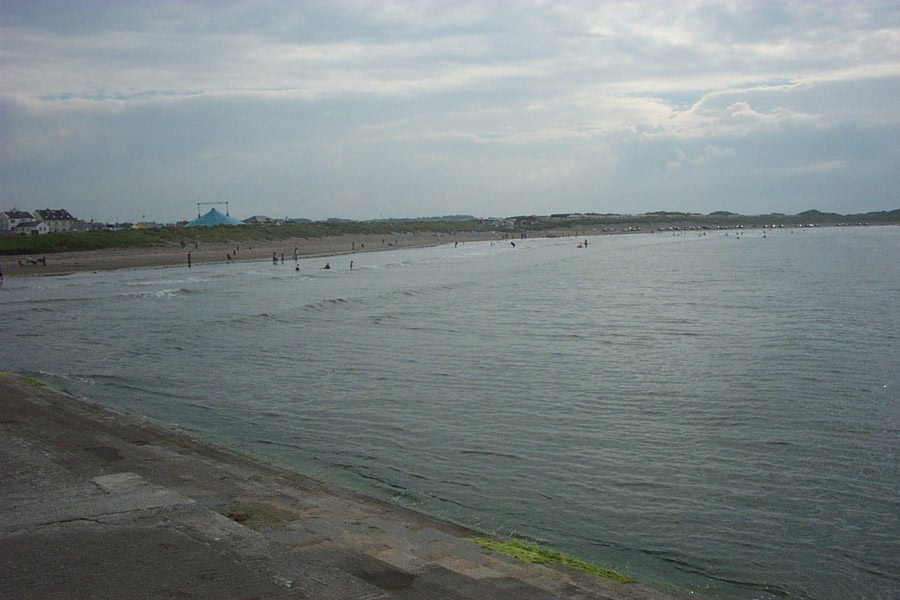
Enniscrone's public sandy beach stretches over a long area of shoreline, and is split near the lower part of the village by a small crossable river. Part of the beach is overseen by lifeguards in the summer period.
The "Valley of Diamonds" is one of the hidden features along the beach, and is the largest of the "volcano-like" compositions among the long-grassed sand dunes. Sligo County Council fenced off the sand dunes as part of their "Dune Restoration Works Programme". Other county council restrictions include limiting road access to the beach, a measure taken to maintain Enniscrone's Blue Flag beach status.
References
References
- "Enniscrone (Ireland) Census Town".
- "Inishcrone/Inis Crabhann". Placenames Database of Ireland.
- "Enniscrone or Inishcrone? Campaign intensifies to end confusion over name".
- (October 2014). "Enniscrone Local Area Plan 2014–2020". Sligo County Council.
- "Carrowhubbuck South Townland, Co. Sligo - Bordering townlands". Townlands Ireland.
- "Ceathrú Hobac Theas / Carrowhubbuck South". Irish Placenames Commission.
- (15 August 2007). "Green light for major Enniscrone development". [[Western People]].
- (1995). "Record of Monuments and Places as established under Section 12 of the National Monuments (Amendment) Act 1994". National Monuments and Historic Properties Service.
- "Inishcrone Castle, Carrowhubbock South, Sligo". National Inventory of Architectural Heritage.
- "Kilglass Church of Ireland, Kilglass, Sligo". National Inventory of Architectural Heritage.
- "Carrowhubbuck South, Inishcrone, Sligo". National Inventory of Architectural Heritage.
- "Church of the Assumption".
- Lewis, Samuel. (1837). "[[A Topographical Dictionary of Ireland]]". Lewis.
- (15 August 2020). "Recalling a forgotten attack a century ago". Independent News & Media.
- "IRA capture of Inishcrone Coastguard Station". Irish Defence Forces - Military Archives.
- "Cliff Baths, Carrowhubbuck South, Inishcrone, Sligo". National Inventory of Architectural Heritage.
- "Kilcullen's Seaweed Baths, Carrowhubbuck South, Inishcrone, Sligo". National Inventory of Architectural Heritage.
- "Enniscrone County Sligo".
- "Enniscrone National School (Scoil Chríost Rí, Enniscrone)". Department of Education.
- (9 August 2006). "Local Notes - Enniscrone". [[The Sligo Champion]].
- "Quirky Glamping Village - Unique glamping experience".
- (7 May 2017). "A year after hauling a 767 up the Shannon, Sligo's glamping project has hit a funding snag". Journal Media Limited.
- (5 August 2018). "Happy Glamper: You'll find planes, trains and even a tank in Enniscrone's new glamping village". Independent News & Media.
- "Enniscrone Beach".
- "Bathing Water Profile: Enniscrone".
This article was imported from Wikipedia and is available under the Creative Commons Attribution-ShareAlike 4.0 License. Content has been adapted to SurfDoc format. Original contributors can be found on the article history page.
Ask Mako anything about Enniscrone — get instant answers, deeper analysis, and related topics.
Research with MakoFree with your Surf account
Create a free account to save articles, ask Mako questions, and organize your research.
Sign up freeThis content may have been generated or modified by AI. CloudSurf Software LLC is not responsible for the accuracy, completeness, or reliability of AI-generated content. Always verify important information from primary sources.
Report