From Surf Wiki (app.surf) — the open knowledge base
Eastern Samar
| Field | Value | |||
|---|---|---|---|---|
| name | Eastern Samar | |||
| native_name | fil | |||
| settlement_type | ||||
| image_skyline | {{Photomontage | |||
| photo1a | View of the Leyte Gulf and Manicani Island from the Guiuan Terminal in April 2022 (1).jpg | |||
| photo2a | Baybay seafront.jpg | |||
| photo3a | Church of San Julian, Eastern Samar.jpg | |||
| photo3b | Homonhon quincentennial historical marker - NHCP - 1.jpg | |||
| photo4a | BARANGAY BOLUSAO Olot White Beach.jpg | |||
| size | 250 | |||
| spacing | 2 | |||
| color | transparent | |||
| border | 0 | |||
| image_caption | (from top: left to right) Port section of the Guiuan Integrated Transport Terminal, Baybay Boulevard in Borongan, Balangiga Church, Church of San Julian, Homonhon and Olot Beach. | |||
| image_flag | ||||
| flag_size | 120x80px | |||
| image_seal | Eastern Samar seal.svg | |||
| seal_size | 100x80px | |||
| image_map | ||||
| map_caption | Location in the Philippines | |||
| coordinates | ||||
| subdivision_type | Country | |||
| subdivision_name | ||||
| subdivision_type1 | Region | |||
| subdivision_name1 | ||||
| established_title | Founded | |||
| established_date | June 19, 1965 | |||
| seat_type | Capital | |||
| and largest city | ||||
| seat | ||||
| leader_title | Governor | |||
| leader_name | Ralph Vincent M. Evardone (PFP) | |||
| leader_title1 | Vice Governor | |||
| leader_name1 | Maria Caridad S. Goteesan (PFP) | |||
| leader_title2 | Legislature | |||
| leader_name2 | Eastern Samar Provincial Board | |||
| area_footnotes | ||||
| area_total_km2 | ||||
| area_rank | 24th out of 82 | |||
| elevation_max_m | 673 | |||
| elevation_max_point | Mount Mactaon | |||
| population_footnotes | ||||
| population_total | ||||
| population_as_of | ||||
| population_rank | 60th out of 82 | |||
| population_density_km2 | auto | |||
| population_density_rank | 69th out of 82 | |||
| demographics_type1 | Divisions | |||
| demographics1_title1 | Independent cities | |||
| demographics1_info1 | 0 | |||
| demographics1_title2 | Component cities | |||
| demographics1_info2 | {{Collapsible list | |||
| titlestyle | font-weight:normal;text-align:left;background-color:WhiteSmoke; | |||
| title | 1 | |||
| demographics1_title3 | Municipalities | |||
| demographics1_info3 | {{Collapsible list | |||
| titlestyle | font-weight:normal;text-align:left;background-color:WhiteSmoke; | |||
| title | 22 | |||
| demographics1_title4 | Barangays | |||
| demographics1_info4 | 597 | |||
| demographics1_title5 | Districts | |||
| demographics1_info5 | Legislative districts of Eastern Samar | |||
| timezone | PHT | |||
| utc_offset | +8 | |||
| postal_code_type | ZIP code | |||
| postal_code | ||||
| area_code_type | ||||
| area_code | ||||
| iso_code | ||||
| blank_name_sec1 | Spoken languages | |||
| blank_info_sec1 | ||||
| blank_name_sec2 | Highway routes | |||
| blank_info_sec2 | [[File:N670 (Philippines).svg | 21px]] [[File:N674 (Philippines).svg | 21px]] [[File:N676 (Philippines).svg | 21px]] |
| website | ||||
| mapframe | yes | |||
| mapframe-zoom | 8 |
Balangiga Church at night.JPG and largest city | Borongan | Arteche | Balangiga | Balangkayan | Can-avid | Dolores | General MacArthur | Giporlos | Guiuan | Hernani | Jipapad | Lawaan | Llorente | Maslog | Maydolong | Mercedes | Oras | Quinapondan | Salcedo | San Julian | San Policarpo | Sulat | Taft | mapframe-zoom = 8
Eastern Samar (Waray-Waray: Sinirangan Samar; ), officially the Province of Eastern Samar, is a province in the Philippines located in the Eastern Visayas region. Its capital is the city of Borongan, which is the most populous. Eastern Samar occupies the eastern portion of the island of Samar. Bordering the province to the north is the province of Northern Samar and to the west is Samar province. To the east lies the Philippine Sea, part of the vast Pacific Ocean, while to the south lies Leyte Gulf.
History
Spanish colonial era
During his circumnavigation of the globe, Ferdinand Magellan had set foot on the tiny island of Homonhon in the southern part of the province. On March 16, 1521, the area of what is now Eastern Samar is said to be the first Philippine landmass spotted by Magellan and his crew.
In 1596, many names, such as Samal, Ibabao, and Tandaya, were given to Samar Island prior to the coming of the Spaniards in 1596. During the early days of Spanish occupation, Samar was under the jurisdiction of Cebu. Samar and Leyte were later separated from Cebu in 1735. They were split in 1747 but was reversed in 1762 with the approval of the King of Spain, following complaints from the Jesuits. The province of Samar was later established as a distinct province in 1768 after it got separated from the province of Leyte. In 1777, Samar and Leyte split for the last time when it was approved in Madrid in 1786 and had been effective in 1799.
American colonial era
Philippine-American War
Maj. Eugenio Daza Area Commander of General Lukbán's forces for Southeastern Samar
Balangiga Massacre
Main article: Balangiga massacre
Pacification of Samar
Main article: Pacification of Samar
Japanese occupation
In 1944, combined Filipino-American troops involved in the liberation of the Philippines from Japan built in the town of Guiuan the largest military base in the Pacific. In the same town in 1949, approximately 5,000 Russian refugees escaping from communist China temporarily settled on Tubabao Island until 1951, when they were transferred to Australia and the United States.
Philippine independence
Foundation
Eastern Samar, as a province, was created from Samar province through Republic Act No. 4221 on June 19, 1965. Approved by Congress in 1963, it was authored by Samar congressmen Eladio T. Balite (1st district), Fernando R. Veloso (2nd district), and Felipe J. Abrigo (3rd district). The law, ratified in a plebiscite on June 19, 1965, divided Samar into three: Northern Samar, Eastern Samar and (Western) Samar. The first provincial officials of Eastern Samar, aside from the lone district representative, were elected on November 14, 1967, and on January 1, 1968, they officially assumed office.
Contemporary
The capital town of Borongan became a component city by virtue of Republic Act No. 9394 which sought to convert the municipality into a city. The law was ratified on June 21, 2007. However, the cityhood status was lost twice in the years 2008 and 2010 after the LCP questioned the validity of the cityhood law. The cityhood status was reaffirmed after the court finalized its ruling on February 15, 2011, declaring the cityhood law constitutional.
Typhoon Haiyan (Yolanda), one of the strongest typhoons ever recorded, made its first landfall in the coastal town of Guiuan in November 2013.
Geography
Eastern Samar covers a total area of 4,660.47 km2 occupying the eastern section and majority of southern Samar's coast of Samar Island in the Eastern Visayas region. The province is bordered to the north by Northern Samar and to the west by Samar. To the east lies the Philippine Sea, part of the vast Pacific Ocean, while to the south lies Leyte Gulf.
Because it faces the Philippine Sea of the Pacific Ocean, Eastern Samar suffers heavily from powerful typhoons.
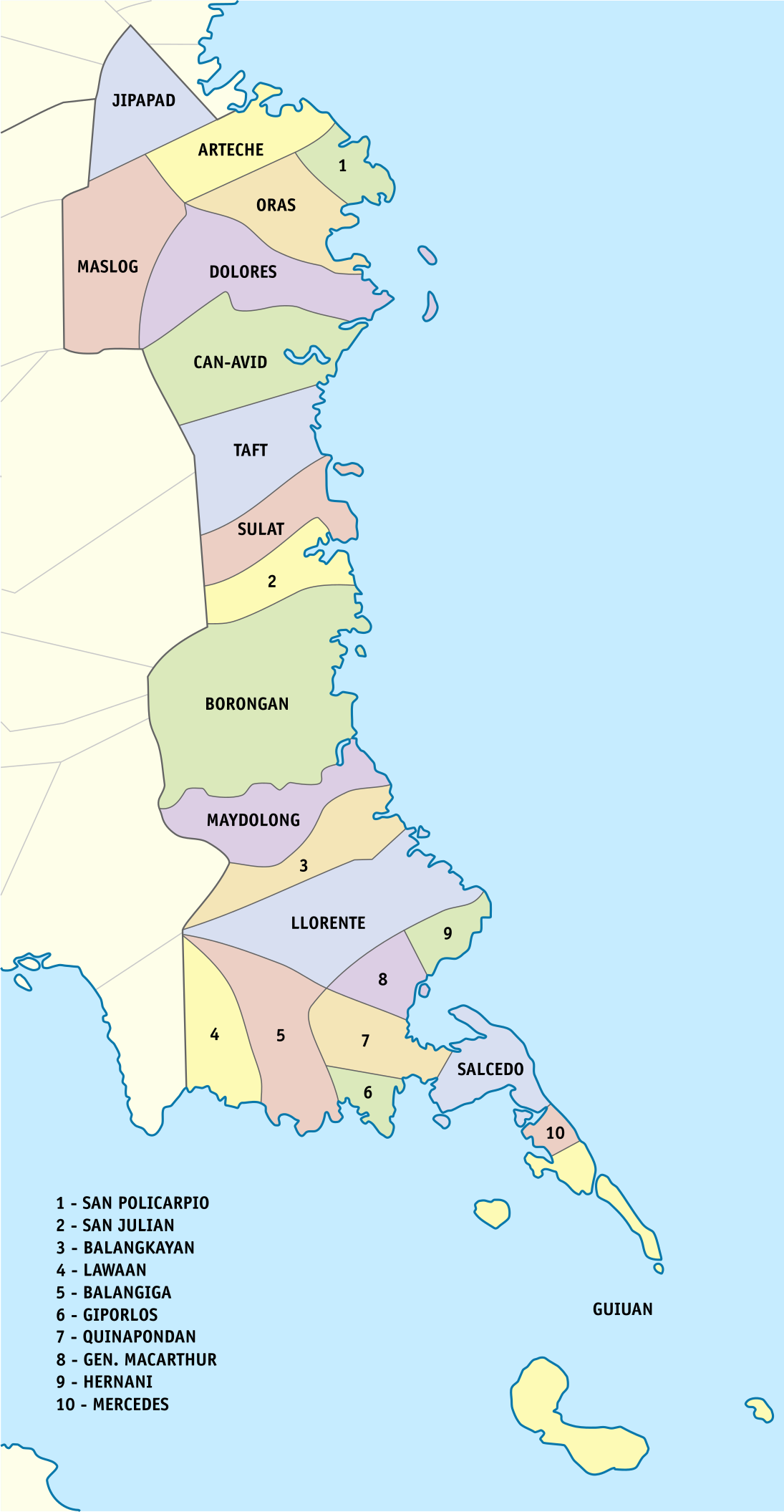
Administrative divisions
Eastern Samar comprises 22 municipalities and one city, all encompassed by an lone congressional district and two provincial districts that elect a representative and provincial board members, respectively.
| City or municipality | Population | Area | Density | Barangay | (2020) | (2015) | km2 | sqmi | /km2 | /sqmi | Total | 477,168 | 467,160 | 4,617.16 | 4,617.16 km2 | {{sigfig | 477,168/4,617.16 | 2}} PD/km2 | 597 |
|---|---|---|---|---|---|---|---|---|---|---|---|---|---|---|---|---|---|---|---|
| Arteche | 16,026 | 138.81 km2 | {{sigfig | 16,360/138.81 | 2}} PD/km2 | 20 | |||||||||||||
| Balangiga | 14,085 | 190.05 km2 | {{sigfig | 14,341/190.05 | 2}} PD/km2 | 13 | |||||||||||||
| Balangkayan | 10,125 | 207.05 km2 | {{sigfig | 10,185/207.05 | 2}} PD/km2 | 15 | |||||||||||||
| Borongan City | † | 69,297 | 475.00 km2 | {{sigfig | 71,961/475.00 | 2}} PD/km2 | 61 | ||||||||||||
| Can-avid | 21,015 | 288.70 km2 | {{sigfig | 21,682/288.70 | 2}} PD/km2 | 28 | |||||||||||||
| Dolores | 42,866 | 308.58 km2 | {{sigfig | 44,626/308.58 | 2}} PD/km2 | 46 | |||||||||||||
| General MacArthur | 14,550 | 117.29 km2 | {{sigfig | 14,411/117.29 | 2}} PD/km2 | 30 | |||||||||||||
| Giporlos | 13,308 | 97.51 km2 | {{sigfig | 13,117/97.51 | 2}} PD/km2 | 18 | |||||||||||||
| Guiuan | 52,991 | 175.49 km2 | {{sigfig | 53,361/175.49 | 2}} PD/km2 | 60 | |||||||||||||
| Hernani | 8,573 | 49.42 km2 | {{sigfig | 8,531/49.42 | 2}} PD/km2 | 13 | |||||||||||||
| Jipapad | 7,885 | 234.80 km2 | {{sigfig | 8,439/234.80 | 2}} PD/km2 | 13 | |||||||||||||
| Lawaan | 12,742 | 162.56 km2 | {{sigfig | 13,003/162.56 | 2}} PD/km2 | 16 | |||||||||||||
| Llorente | 20,149 | 496.07 km2 | {{sigfig | 21,459/496.07 | 2}} PD/km2 | 33 | |||||||||||||
| Maslog | 5,407 | 249.80 km2 | {{sigfig | 5,463/249.80 | 2}} PD/km2 | 12 | |||||||||||||
| Maydolong | 14,743 | 399.63 km2 | {{sigfig | 15,314/399.63 | 2}} PD/km2 | 20 | |||||||||||||
| Mercedes | 6,070 | 23.32 km2 | {{sigfig | 6,112/23.32 | 2}} PD/km2 | 16 | |||||||||||||
| Oras | 36,540 | 188.70 km2 | {{sigfig | 37,451/188.70 | 2}} PD/km2 | 42 | |||||||||||||
| Quinapondan | 14,779 | 83.24 km2 | {{sigfig | 14,507/83.24 | 2}} PD/km2 | 25 | |||||||||||||
| Salcedo | 22,532 | 113.80 km2 | {{sigfig | 22,136/113.80 | 2}} PD/km2 | 41 | |||||||||||||
| San Julian | 14,498 | 150.62 km2 | {{sigfig | 14,800/150.62 | 2}} PD/km2 | 16 | |||||||||||||
| San Policarpo | 14,687 | 65.70 km2 | {{sigfig | 15,365/65.70 | 2}} PD/km2 | 17 | |||||||||||||
| Sulat | 15,377 | 169.75 km2 | {{sigfig | 15,758/169.75 | 2}} PD/km2 | 18 | |||||||||||||
| Taft | 18,915 | 231.27 km2 | {{sigfig | 18,786/231.27 | 2}} PD/km2 | 24 | |||||||||||||
| Provincial capital and component city | Municipality |
Demographics
The population of Eastern Samar in the 2024 census was 472,683 people, with a density of {{sigfig|472,683/4,660.47|2}} PD/km2. The predominant language is Waray and it is the main lingua franca of the entire island of Samar.
In the 2000 Census, Warays comprised of the total provincial population of 375,124 at that time. Kapampangan came second at , Bisaya/Binisaya , Cebuano at , and Tagalog at .
Religion
Main article: Religion in the Philippines
Catholicism
The people of the province are devoted Catholics where a majority adhere to Roman Catholicism. The dominant Catholic faith influences the events of the provincial education, politics and social functions of the people.
Others
Other Christians usually form the remaining groups of believers such as the Born-again Christians, Protestants, Iglesia Filipina Independiente or Aglipayan church, Jehovah's Witnesses, Iglesia ni Cristo, Baptists, Methodists, The Church of Jesus Christ of Latter-day Saints, and Seventh-day Adventists. Non Christians (mostly Muslims) are also found.
Transportation
The province has one operational airport; Borongan Airport located in the capital city. Currently, only Leascor operates out of Borongan Airport with flights weekly to serve locals and tourists to and from Cebu.
By land, mini buses and vans ply from the regional center in Tacloban, Catbalogan, and Calbayog in Samar province and to some towns in Eastern Samar. From Borongan, buses ply to Metro Manila. Motorized boats plies through Leyte Gulf ferrying passengers going to Tacloban City seaport.
Economy
Commercial activities in the province are centered on the provincial capital of Borongan while tourism activities are centered in Guiuan town where Calicoan Island and the historical Homonhon Island are located. Generally, the province's major economic resource is fishery and agriculture which include production of coconut, copra, corn, rice, sugar, and vegetables. Tourism potential is untapped on the northern part of the province.
Notable people
- Boy Abunda - television host, publicist, talent manager and celebrity endorser.
- Maria Fe Abunda - politician; Eastern Samar's representative in the House of Representatives of the Philippines. 8th and 19th Congress.
- Aster Amoyo - entertainment writer, television host, and talent manager.
- Gabrielle Camille Basiano - model and beauty pageant titleholder, Binibining Pilipinas Intercontinental 2022.
- K Brosas - actress, comedienne and singer.
- Eugenio Daza - Area Commander Southeastern Samar during the Philippine-American War. Organizer of the Balangiga Encounter. Rep. of Samar's 3rd District to the First Philippine Legislature.
- Gabriel Daza - Knight Commander with Star of the Order of St. Sylvester, knighted by Pope Pius XII. Co-founder Boy Scouts of the Philippines.
- R-Ji Lim - singer, actor and model; member of P-pop group Alamat.
- Jewel Ponferada - PBA professional basketball player, currently playing for Rain or Shine Elasto Painters.
- Art Ramasasa - singer, songwriter and musician in the Waray-Waray language.
- Mastermind - dance group, made popular in their performance in Pilipinas Got Talent season 5. They finally settled for 4th place in the Grand Finals.
- Freddie Abuda - retired professional basketball player, currently serving as an assistant coach to the San Beda Red Lions (NCAA).
- Lutgardo Barbo - Former governor of Eastern Samar, Candidate for the 2022 Senate Elections.
- Marcelino Libanan - Filipino politician. Minority Leader 19th and 20th Congress. 4P's Partylist Representative
- Ben Evardone - Congressman of Eastern Samar and 6th Governor of Eastern Samar.
- RV Evardone - Governor, Province of Eastern Samar. Former President of the Eastern Samar chapter of the Philippine Councilors League,
- Sheen Gonzales - Two-term mayor of Guiuan, Representative, Lone District of Eastern Samar. Assistant Minority Leader of the 2oth Congress.
- Andres Pagaran - poet and songwriter
References
References
- "List of Provinces". National Statistical Coordination Board.
- "Mapa ng mga Wika (Rehiyon) - Rehiyon VIII". [[Commission on the Filipino Language]].
- (1995). "Fast Facts about Philippine Provinces". Tahanan Books.
- (11 June 2011). "Guiuan's treasure chest of history, natural wonders". [[Philippine Daily Inquirer]].
- "The Province of Eastern Samar".
- "Samar History and Information".
- (June 19, 1965). "An Act Creating the Provinces of Northern Samar, Eastern Samar and Western Samar".
- (March 16, 2007). "An Act Converting the Municipality of Borongan in the Province of Eastern Samar Into a Component City to Be Known as the City of Borongan".
- Punay, Edu. (April 13, 2011). "SC affirms cityhood ruling".
- (22 November 2013). "How One Philippine Town Avoided Calamity". The Wall Street Journal.
- (7 June 2002). "Eastern Samar: Home of the Warays; Table 4. Household Population by Ethnicity and Sex: Eastern Samar, 2000".
- (1995). "Tinipigan: An Anthology of Waray Literature". National Commission for Culture and the Arts.
This article was imported from Wikipedia and is available under the Creative Commons Attribution-ShareAlike 4.0 License. Content has been adapted to SurfDoc format. Original contributors can be found on the article history page.
Ask Mako anything about Eastern Samar — get instant answers, deeper analysis, and related topics.
Research with MakoFree with your Surf account
Create a free account to save articles, ask Mako questions, and organize your research.
Sign up freeThis content may have been generated or modified by AI. CloudSurf Software LLC is not responsible for the accuracy, completeness, or reliability of AI-generated content. Always verify important information from primary sources.
Report