From Surf Wiki (app.surf) — the open knowledge base
East Norwich, New York
| Field | Value | |
|---|---|---|
| official_name | East Norwich, New York | |
| settlement_type | Hamlet and census-designated place | |
| motto | ||
| image_skyline | East Norwich Inn; NW Corner of NY 25A-106.jpg | |
| image_caption | East Norwich's downtown area in 2019 | |
| image_seal | ||
| pushpin_map | USA New York Long Island#New York | |
| pushpin_label_position | top | |
| pushpin_map_caption | Location on Long Island##Location within the state of New York | |
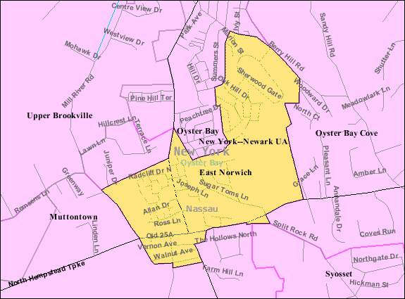
| image_map | Nassau County New York incorporated and unincorporated areas East Norwich highlighted.svg | |
| mapsize | 260px | |
| map_caption | Location in Nassau County and the state of New York. | |
| <!-- Location --> | subdivision_type | Country |
| subdivision_name | United States | |
| subdivision_type1 | State | |
| subdivision_name1 | New York | |
| subdivision_type2 | County | |
| subdivision_name2 | Nassau | |
| established_date | ||
| area_footnotes | ||
| area_total_km2 | 2.72 | |
| area_land_km2 | 2.72 | |
| area_water_km2 | 0.00 | |
| area_total_sq_mi | 1.05 | |
| area_land_sq_mi | 1.05 | |
| area_water_sq_mi | 0.00 | |
| <!-- Population --> | population_as_of | [2020](2020-united-states-census) |
| population_total | 2792 | |
| population_density_km2 | 1024.63 | |
| population_density_sq_mi | 2653.99 | |
| <!-- General information --> | timezone | Eastern (EST) |
| utc_offset | -5 | |
| timezone_DST | EDT | |
| utc_offset_DST | -4 | |
| elevation_m | 61 | |
| elevation_ft | 200 | |
| coordinates | ||
| postal_code_type | ZIP code | |
| postal_code | 11732 | |
| area_code | 516, 363 | |
| blank_name | FIPS code | |
| blank_info | 36-22623 | |
| blank1_name | GNIS feature ID | |
| blank1_info | 0949190 | |
| pushpin_label | East Norwich, New York | |
| unit_pref | Imperial | |
| subdivision_name3 | Oyster Bay | |
| subdivision_type3 | Town | |
| area_code_type | Area codes |
East Norwich (formerly known as Norwich) is a hamlet and census-designated place (CDP) located within the Town of Oyster Bay in Nassau County, on the North Shore of Long Island, in New York, United States. The population was 2,792 at the time of the 2020 census.
History
East Norwich was originally named Norwich, until the postal service requested the name change to eliminate confusion from the other Norwich, in Chenango County.
Geography
According to the United States Census Bureau, the CDP has a total area of 1.0 sqmi, all land.
Topography
Like the rest of Long Island's North Shore, East Norwich is situated on a terminal moraine, which is named the Harbor Hill Moraine. This moraine was formed by glaciers during the Wisconsin Glacial Episode, and is named for Harbor Hill in Roslyn; Harbor Hill is the highest geographic point in Nassau County.
Climate
Under the Köppen climate classification, East Norwich lies in the transition zone between a humid subtropical climate (Cfa) and a hot-summer humid continental climate (Dfa). As such, summers are usually hot and humid with occasional thunderstorms, winters are usually cool with snow and rain, and the spring and fall typically feature mild weather.
Demographics
As of the census of 2010, there were 2,709 people, 966 households, and 772 families residing in the CDP. The population density was 2,554.5 PD/sqmi. There were 950 housing units at an average density of 907.2 /sqmi. The racial makeup of the CDP was 93.50% White, 0.80% African American, 3.50% Asian, 1.10% from other races, and 1.10% from two or more races. Hispanic or Latino of any race were 4.40% of the population.
There were 943 households, out of which 35.5% had children under the age of 18 living with them, 69.4% were married couples living together, 9.8% had a female householder with no husband present, and 18.1% were non-families. 15.1% of all households were made up of individuals, and 7.8% had someone living alone who was 65 years of age or older. The average household size was 2.85 and the average family size was 3.19.
In the CDP, the population was spread out, with 26.6% under the age of 19, 4.1% from 20 to 24, 21.3% from 25 to 44, 31.9% from 45 to 64, and 16.0% who were 65 years of age or older. The median age was 43.5 years. For every 100 females, there were 91.57 males. For every 100 females age 18 and over, there were 88.0 males.
The median income for a household in the CDP was $134,309, and the median income for a family was $159,890. Males had a median income of $114,934 versus $86,250 for females. The per capita income for the CDP was $62,052. About 4.0% of families and 4.0% of the population were below the poverty line, including 5.8% of those under age 18 and 1.1% of those age 65 or over.
Education
School district
East Norwich, in its entirety, is served by the Oyster Bay–East Norwich Central School District. As such, all children who reside within the village and attend public schools go to Oyster Bay–East Norwich's schools.
Library district
East Norwich is located entirely within the service area of the Oyster Bay–East Norwich Library District, which is served by the Oyster Bay–East Norwich Public Library.
Infrastructure
Transportation
Road
Two state routes pass through and serve East Norwich: New York State Route 25A and New York State Route 106. Other major roads located either partially or wholly within the village include Highwood Road and Sugar Toms Lane.
Rail
No rail lines or train stations exist within East Norwich. The nearest Long Island Rail Road stations to the hamlet are Oyster Bay on the Oyster Bay Branch, and Syosset on the Port Jefferson Branch.
Bus
No bus routes pass through or serve East Norwich.
Utilities
Natural gas
National Grid USA provides natural gas to homes and businesses that are hooked up to natural gas lines in East Norwich.
Power
PSEG Long Island provides power to all homes and businesses within East Norwich.
Water
East Norwich is located within the boundaries of – and is thus served by – the Jericho Water District and the Oyster Bay Water District.
Sewage
The majority of East Norwich is not connected to a sanitary sewer system, instead relying on cesspools and other septic systems. The portion of East Norwich which is connected to sanitary sewers is served located within the boundaries of – and is thus served by – the Oyster Bay Sewer District.
Notable people
- Thomas Pynchon – Author.
- Consuelo Vanderbilt – Socialite; member of the Vanderbilt family.
References
References
- "ArcGIS REST Services Directory". United States Census Bureau.
- Winsche, Richard. (October 1, 1999). "The History of Nassau County Community Place-Names". Empire State Books.
- (2011-02-12). "US Gazetteer files: 2010, 2000, and 1990". [[United States Census Bureau]].
- "Garvies Point Museum and Preserve - Geology of Long Island". Garvies Point Museum.
- (July 2025). "Geology – Friends of the Bay". Friends of the Bay }}{{Dead link.
- (February 29, 2012). "Updated world map of the Köppen–Geiger climate classification". Hydrol. Earth Syst. Sci..
- "PRISM Climate Group at Oregon State University".
- "Census of Population and Housing". Census.gov.
- "U.S. Census website". [[United States Census Bureau]].
- "East Norwich Data".
- "Long Island Index: Interactive Map". Long Island Index.
- "Nassau Inter-County Express - Maps and Schedules".
- "Long Island Utility Information - LIPA, Nat Grid, & Local Water Authorities.".
- "Natural Gas & Electricity {{!}} National Grid".
- "Home Page - PSEG Long Island".
- "Public Works {{!}} Roslyn, NY".
- "Wastewater Management Program {{!}} Nassau County, NY - Official Website".
- "Sewerage Map – Nassau County".
- Forgeron, Harry V.. (1977-10-09). "Conversion of Millionaire Estates on L.I. to Country Clubs Pleases Both Owners and Village Neighbors". The New York Times.
This article was imported from Wikipedia and is available under the Creative Commons Attribution-ShareAlike 4.0 License. Content has been adapted to SurfDoc format. Original contributors can be found on the article history page.
Ask Mako anything about East Norwich, New York — get instant answers, deeper analysis, and related topics.
Research with MakoFree with your Surf account
Create a free account to save articles, ask Mako questions, and organize your research.
Sign up freeThis content may have been generated or modified by AI. CloudSurf Software LLC is not responsible for the accuracy, completeness, or reliability of AI-generated content. Always verify important information from primary sources.
Report